Integrated Information Management
System, Development of Web Interface,
a.k.a. Online Data Portal (ODP)
USBR Science and Technology Project ID 3625
Eric Peterson, May 2014.
Duration: Fiscal Year 2010 through Fiscal Year 2011
Project Abstract
We regard the development of IIMS prior to this proposal as highly successful, yet several limitations were identified that endangered the purpose of IIMS as information repository for intergovernmental restoration partnerships.
Proposed Solution. Implementing full IIMS capabilities through the web would solve the limitations identified AND would improve data stewardship.
The completed project, now called the Online Data Portal (ODP) has been implemented as a “cloud server”, with a replicable server image that can be implemented by other programs on demand. The ODP continues to grow beyond the original S&T proposal with added funding from the Trinity River Restoration Program. TRRP's ODP implementation is publicly accessible at http://odp.trrp.net.
Research Question
Starting in 2006, the Science and Technology (S&T) Program provided a 3-year grant to develop IIMS (Proposal No. 165 IIMS--an Information and Data Management System for Science Based River Management, 2009). Combined with additional funds from partners, this produced a system for data maintenance and access that has improved river management. However, limitations were identified that this project sought to overcome.
Original IIMS highlights:
Centralized database
o Modular data structure for multiple data types
o Automated import of select data types
Desktop application with access to centralized database
o Data query and extraction for external analysis
o Time series analyst (TSA) to graphically view data
o Document library
o Preliminary data management tools including upload capabilities
ArcGIS extension for spatial query of data
Realty module for land access agreements
Web portal with simplified versions of:
o Document Library
o A geospatial viewer Limitations identified included:
Maintaining links between desktop software and centralized databases was IT-intensive
Deployment to additional area offices required customized SMS packaging
These limits endangered the utility of IIMS for river management by making it difficult to deploy! Proposed solution. Implementing full IIMS capabilities through the Web would solve the limitations identified AND would improve data stewardship (data management and documentation) by:
Simplifying interface-database connections by restructuring to a single dedicated link.
Eliminating need for desktop installs.
Equilibrating data access for river restoration partnerships.
Leveraging Web access for more robust data stewardship.
Lessons Learned
Database technologies have expanded considerably over the years in parallel with the Trinity River Restoration Program's (TRRP's) efforts with the Integrated Information Management System (IIMS), now called the Online Data Portal (ODP). If the project were to begin completely anew today, there might be several off-the-shelf options to consider.
However, we began the endeavor in 2006, with this proposal in 2010 being another major point of
advancement, when alternatives were still weak, if they existed at all. Development of the IIMS / ODP has thus provided additional years of collaborative information resources for the Trinity River Restoration Program than would have otherwise been possible!
The result is an online information database system very well tuned to the needs of multiagency restoration programs, and which is available as needed for other collaborative programs.
Conclusion
TRRP's implementation of ODP is at http://odp.trrp.net. See figures below for examples. The implementation includes:
An Amazon-based Cloud Server
Modular data structure
Extensive data importation and management features
Libraries for:
o Documents
o Data Packages
o Meeting Materials
Data visualization with the Time Series Analyst
o Locations over time such as streamgages, reservoir data, temperature monitoring
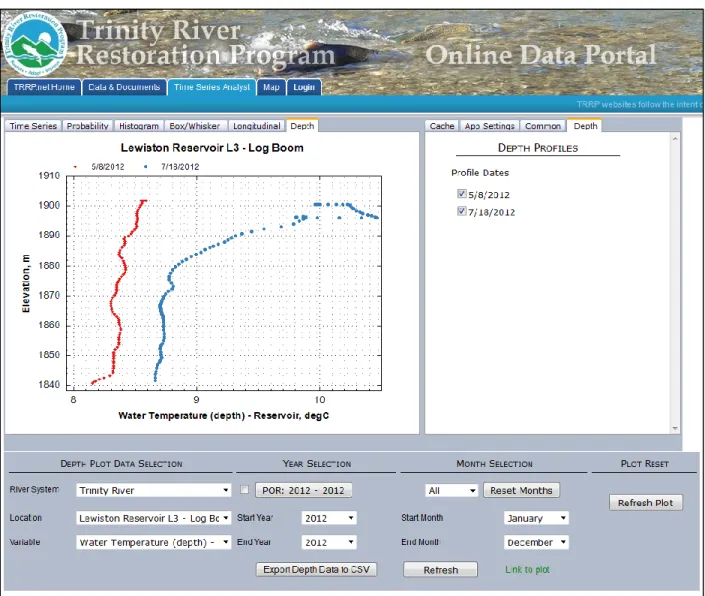
o Depth profiles for data such as temperature at various depths in reservoirs
o Longitudinal profiling of data along stream networks, including tributaries
Geospatial viewer for exploration of both raster and vector data services from ArcServer
A separately funded Project proposal and management system
An image of the ODP cloud server suitable for standing up within the Amazon Cloud services is available upon request to the TRRP Data Steward: Eric Peterson.
Future
The TRRP is continuing development of the ODP. The current focus is on refinement of an Investigation Planning module and enhancements of the ODP Map.
Figure 2: Results from a search at the home page, showing (A) time series data, (B) a “Data Package” from the Data Package Library, (C) a document from the Document Library, and (D) a meeting from the separately funded meeting management module.
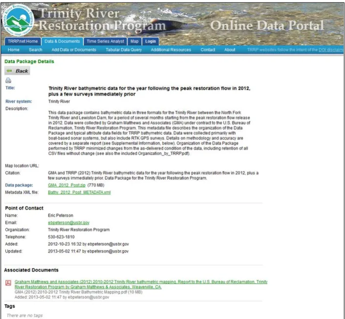
Figure 4: Details page for data in the Data Package Library. Note inclusion of a metadata file, which is
included in the search on the ODP home page.
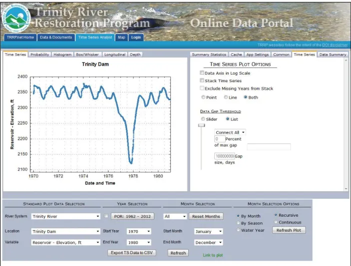
Figure 6: Time Series Analyst demonstrated showing data for the surface elevation of Trinity Reservoir, 1970-1980.
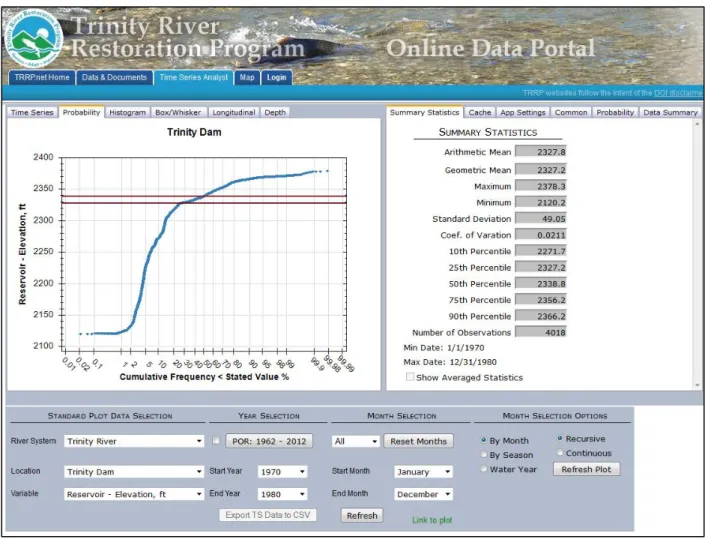
Figure 7: Time Series Analyst showing the same data as Figure 6, but as a probability plot, and with control lines interactively added for the mean (red) and median values (orange).
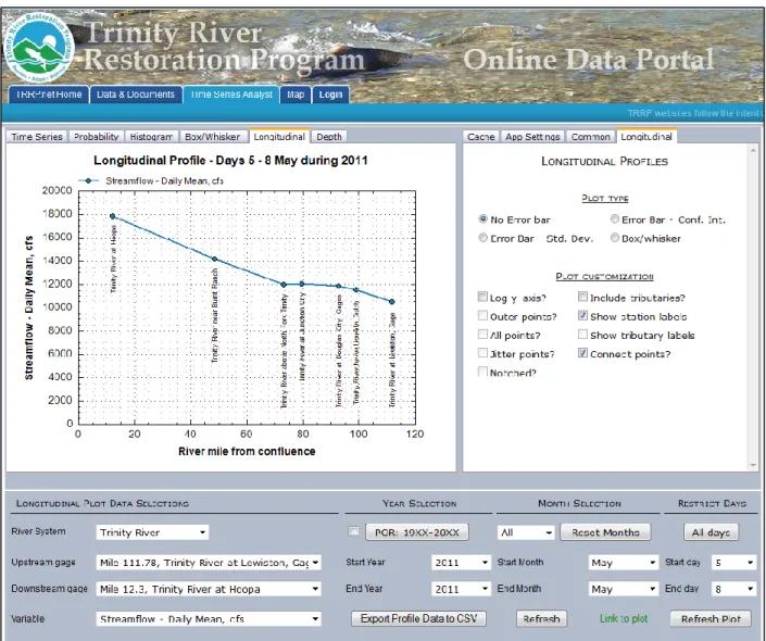
Figure 8: Time Series Analyst showing a longitudinal plot of seven streamgages during a restoration flow release in 2011.
Figure 10: The ODP interactive map displaying default layers (streamgages and TRRP restoration sites) with the call-out box displayed for one streamgage. Note the hyperlinks within the call-out that link to the streamgage data values both within the ODP and from the USGS NWIS database (The ODP includes streamgage data from other sources not available in NWIS).
Figure 11: The ODP interactive map zoomed to a 2013 restoration site, displaying site boundaries and restoration features within the site, overlaying high resolution aerial photography from 2011. Note layer controls on right, a description of the most recently clicked on layer, and a link to download the data from the ODP Data Package Library.
Figure 12: The ODP interactive map showing 1944 aerial photography overlain by the 2011 wetted channel and the modeled maximum restoration flow. Note display of map legend in this figure.
Figure 14: Administrative Control Panel.
Figure 17: Map layers management page. Note arrows providing controls to move layers up or down in the drawing order.
Figure 19: TRRP’s primary website with a reference citation list built dynamically from the ODP Document Library. All documents given the “outmigration” tag will be identified by a custom query (Figure 18) for display on this page, with links to take end users to the documents themselves.