Expansion Project
Construction Environme
n
tal Management Document
AHEPDRAAPP0001 Rev 6 21 October 2019
Contents
Chapter 1 Introduction
Chapter 2 Roles and Responsibilities of Staff Chapter 3 Construction Method Statement Chapter 4 Archaeology Plan
Chapter 5 Construction Lighting Management Plan Chapter 6 Construction Traffic Management Plan
Chapter 7 Dredging and Dredge Spoil Disposal Management and Monitoring Plan
Chapter 8 Fish Species Protection Plan
Chapter 9 Habitat Management Plan and Otter Protection Plan Chapter 10 Landscape Mitigation Compensation Plan
Chapter 11 Marine Mammal Mitigation Plan
Chapter 12 Marine Non-Native Species and Biosecurity Management Plan
Chapter 13 Noise and Vibration Management Plan Chapter 14 Piling Management Plan
Chapter 15 Pollution Prevention Plan
Chapter 16 Nigg Bay Site of Special Scientific Interest
Management Plan Chapter 17 Vessel Management Plan Chapter 18 Waste Management Plan
Chapter 19 Existing Abstractions and Discharges
Chapter 20 Ground Gas and Groundwater Report: Phase II Site Investigation Risk Assessment
Chapter
1
7
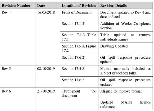
Revision Log
Revision Number Date Location of Revision Revision Details
Rev 4 16/05/2018 Front of Document Document updated to Rev 4 and date updated
Section 17.1.2 Addition of Works Completed Section
Section 17.1.3, Table 17.1
Table updated to remove individuals names
Section 17.5.3, Figure 17.2
Drawing Updated
Section 17.6.2 Oil spill response procedure updated
Rev 5 08/10/2019 Section 17.4.8 Marine mammals included as subject of toolbox talks.
Section 17.6.2 Oil spill response procedure updated
Rev 6 21/10/2019 Throughout the document
Aligned to improve format
Updated Marine licence reference
Contents
Page
17 Vessel Management Plan 1
17.1 Introduction 1
17.2 Contacts and Emergency Information 4 17.3 Guidelines for Dragados 8 17.4 Guidelines for Vessels 10
17.5 Vessel Movement 13
17.6 Incident and Pollution Response 18
Appendices
Appendix A
Vessel Activity Register
Appendix B
Aberdeen Harbour Published Guidance
Appendix C
17
Vessel Management Plan
17.1
Introduction
17.1.1
Objective
This document was developed to provide information on the vessel management requirements and procedures associated with the proposed construction stage of the Aberdeen Harbour Expansion Project (AHEP). Dragados acknowledges the need to manage and monitor construction vessel movements during throughout the life cycle of the construction process. A Vessel Management Plan (VMP) provides a formal means through which such management and monitoring can be implemented in a structured, organised manner.
This VMP should be treated as a ‘live’ document and will be updated throughout all stages of the construction process in accordance with changes to the construction works. It provides a framework for managing the implementation of all construction vessel activity resulting from the construction process, and identifying a range of mitigation measures to help minimise any potential environmental and marine impacts on the surrounding area.
Dragados will ensure that all vessels associated with the dredging and deposit activities adhere to the approved VMP. The route to and from the deposit site is at the vessel master, Harbour Master and Aberdeen Vessel Traffic Services (VTS)’s discretion, subject to the port operations and environmental conditions.
VMP must include details on vessels, their expected speeds, anticipated routes and frequency of trips during the licensed activities, creations of high and low disturbance areas, a vessel free buffer zone around Girdleness and Greyhope Bay, and details of how vessel management will be coordinated.
Relative to the operation of the harbour, the VMP must include a code of practice to guide the behaviour of vessels in and in the vicinity of the harbour around marine mammals and rafts of birds and avoidance of the area around Girdleness and Greyhope Bay. An Operational Environmental Management Plan will be produced at a later date to cover operational vessel requirements.
17.1.2
Work Completed
The following works have been carried out:
Establishment of the dedicated project communication channels as outlined in Section 17.2.4; and
The notices to Marine Scotland, Her Majesty’s Coastguard (HMCG) and Mariners were provided as per Section 17.3 prior to 2017 dredging activities commencing.
For 2019 the contractor Van Oord have dredged 737,285 m3 of material as of 27/08.
17.1.3
Roles, Responsibilities and Cross-Referencing
Table 17.1 details the responsibilities that selected members of staff have relating to the management of project vessels.
Table 17.1: Roles and Responsibility Table
Job Title Responsibilities
Construction Marine Coordinator VTS procedures
Emergency coordination and management
Incident and pollution response coordination with Aberdeen Harbour
Ensure general compliance with regulations Marine licencing conditions
Managing the vessel movement log Coordination with dredging contractors Enforcement of exclusion zones Adverse weather protocol Force majeure response
Automatic Identification Systems (AIS) monitoring and management
Deputy Coordinator Assisting the Construction Marine Coordinator
17.1.3.1
Cross-Referencing
The VMP should be read in conjunction with the following CEMD’s:
Construction Method Statement;
Pollution Prevention Plan;
Marine Mammal Management Plan;
Fish Species Protection Plan;
Piling Management Plan;
Marine Invasive Non-Native Species and Biosecurity Management Plan;
Habitat Management Plan; and
17.2
Contacts and Emergency Information
The Dragados Health and Safety Plan will be available from the project Health and Safety Manager, and should be consulted and the emergency procedure it provides should be followed.
17.2.1
Emergency Contact Details
Emergency Services
In the event of an emergency occurring in or adjacent to the site, contact the emergency services including Police Scotland, Scottish Ambulance Service, HM Coastguard and Scottish Fire & Rescue Service on:
999
or HM Coastguard on VHF Channel 16
17.2.2
Emergency Services - Non Emergency Numbers
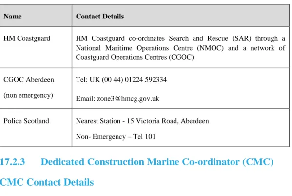
The non emergency contact number (Table 17.2) should be used when the issue does not require immediate attention. In the event of an emergency both on and off-site that does require immediate attention, the offshore CMC and off-site-based Health and Safety Officer must be informed immediately. They will assist any emergency services on site as required with regards to accessing the site and moving site equipment and personnel to allow uninterrupted access.
Table 17.2: Emergency Contact Numbers
Name Contact Details
HM Coastguard HM Coastguard co-ordinates Search and Rescue (SAR) through a National Maritime Operations Centre (NMOC) and a network of Coastguard Operations Centres (CGOC).
CGOC Aberdeen (non emergency)
Tel: UK (00 44) 01224 592334 Email: [email protected]
Police Scotland Nearest Station - 15 Victoria Road, Aberdeen Non- Emergency – Tel 101
17.2.3
Dedicated Construction Marine Co-ordinator (CMC)
CMC Contact Details
In accordance with the mitigation measures of the Environmental Statement (ES), Dragados have appointed a dedicated Construction Marine Co-ordinator (CMC). The primary function of this role is to maintain a complete overview of current and
planned marine construction activities, to liaise daily with VTS and AHB Marine Department on the construction plans and ensure compliance by construction works vessels with the standards set by AHB.
The name and contact details of the appointed CMC are listed in Table 17.3.
Table 17.3: Appointed Dragados Staff
Name of CMC Contact Details
Primary Construction Marine Co-ordinator 01224 063600 Deputy Construction Marine Co-ordinator 01224 063600
CMC Responsibilities
The appointed Construction Marine Coordinator is responsible for the following aspects of marine activity for the project.
VTS procedures (17.2.3);
Emergency coordination and management (17.2.4);
Incident and pollution response coordination with Aberdeen Harbour (17.6);
Ensure general compliance with regulations and practices listed in (17.3.1);
Ensuring marine licencing conditions are adhered to (17.3);
Ensuing that the vessel movement log is accurate, kept up to date and is available for inspection (17.5.1);
Coordination with dredging contractors over their compliance with marine licencing conditions and the completion of the material movement log (17.5.2);
Enforcement of exclusion zones during marine activities (17.4.9);
The correct protocol regarding adverse weather limits for all vessels (17.5.8);
The response in the event of a force majeure (17.5.9);
The correct installation and operation of Automatic Identification Systems (AIS) on all vessels (17.4.5);
17.2.4
Communication Channels
All radio communication between vessels relating to the project will be carried out on channel 13. Communication with other vessels in Aberdeen Harbour not relating to construction activities and with Aberdeen Harbour VTS is carried out on channel 12. In the event of emergencies communication will be carried out on channel 16. All vessels must communicate on these specific channels and must not use other channels for communication without prior permission from the CMC and Aberdeen Harbour Board (AHB). The Coastguard (HMCG) will be made aware of the use of channel 13 for project communications.
No communication is to be carried out on channel 11.
17.2.5
Vessel Traffic Service (VTS)
Contact Information
Vessel Traffic Services (Source: Aberdeen Harbour Website)
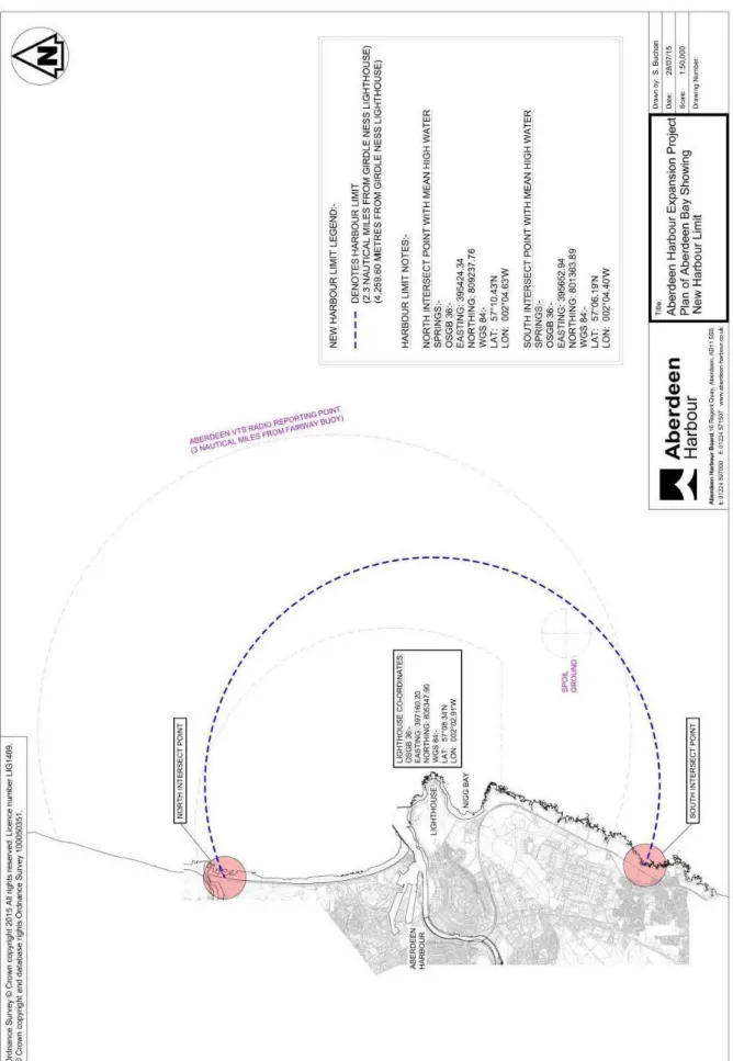
All shipping movements within the Aberdeen VTS area (that area below the level of high water within a radius of 2.3 nautical miles from Girdle
Ness Lighthouse at Aberdeen) are monitored and organised by Aberdeen VTS. Aberdeen VTS provide the following services
Traffic Organisation Services Information Service.
Call: Aberdeen VTS
VHF Frequency Ch 12; 16
Telephone +44(0)1224 597000
Email [email protected]
Participation with VTS is mandatory.
For Additional information on VTS see MGN 401 (M+F) Vessel Traffic Services and Local Port Services in the UK; and MSN 1796 (M+F) Amendment 2: Vessel Traffic Services – Designation of Vessel Traffic Services in the UK
More information can be found online at:
http://www.aberdeen-harbour.co.uk/operations/information-for-port-users/
Appendix A contains the VTS procedure information for all vessels wishing to enter Port Limits as shown in Figure 17.1. It is advised that all masters read this information before working within the project area.
VTS Procedure
All marine contractors operating vessels throughout the duration of the project will establish direct communication between the Vessel Traffic Service (VTS) at Aberdeen Harbour. VTS will be informed of all vessel activity information (including Notice to Mariners and/or radio warnings);
VTS guidance is available on the Aberdeen Harbour website and contained within Appendix B. These guidelines must be followed by all vessels working on the project:
The CMC should ensure that all vessels are aware of VTS and adhere to all their instructions.
17.3
Guidelines for Dragados
17.3.1
Notice to Marine Scotland
Dragados will provide the name of any agent, contractor or sub-contractor appointed to undertake the licensed activities and their role to the Marine Scotland Licencing Operations Team (MS LOT) 72 hours prior to the licensed activities commencing.
The following Marine Licences have been granted for the duration of the project works:
05965/16/0 (Licence to construct, alter or improve works and to deposit or use explosive substances or articles within the Scottish marine area)
05964/19/0 (Licence to carry out dredging and to deposit dredged spoil substances or objects within the Scottish marine area)
If there are changes to any of the details provided, Dragados will notify MS LOT, in writing, prior to any agent, contractor or sub-contractor undertaking any licensed activity.
Dragados will ensure that only those agents, contractors or sub-contractors notified to the MS LOT are permitted to undertake the licensed activities.
Dragados will provide a copy of the Licence and any subsequent variations that have been made to this Licence in accordance with section 30 of the Marine Scotland Act 2010 to any agent, contractor or sub-contractor appointed to carry out any part, or all, of the licensed activities. Dragados will ensure that any such agent, contractor or sub-contractor is aware of and understands the extent of the works for which this Licence has been granted, the activity which is licensed and the terms of the conditions attached to the Licence before allowing work to commence.
In the event that the licensee wishes to update or amend the VMP, the licensee must submit, in writing, details of the proposed updates or amendments to the licensing authority for their written approval, no later than one month or at such a time as agreed with the licensing authority, prior to the planned implementation of the proposed updates or amendments. It is not permissible for any activities associated
with the proposed updates or amendments to proceed prior to the granting of such approval.
Changes to the VMP will be undertaken in line with any change management procedures as outlined in the Environmental Management System (EMS) (Section 7.1).
If any information that was provided to MS LOT to obtain a Licence changes over time, Dragados will disclose these changes to the authority in writing as soon as possible.
In accordance with the Marine Licence, all marine licenses and marine works will be available for inspection by enforcement officers. Licences must be on board all vessels carrying out licenced activities in addition to the contractor’s office. Dragados will be given 72 hours’ notice of any inspections and will provide transport to and from the licenced site.
It is the responsibility of the Construction Marine Coordinator that all marine licencing compliance requirements are met and adhered to throughout the duration of the project.
17.3.2
Notice to HMCG
Dragados will submit a report to HMCG detailing planned activities and a list of all operating vessels on a monthly basis.
17.3.3
Notice to Mariners
In accordance with the Marine Licence, prior to commencement of any marine activity, the marine contractor will provide a detailed Notice to Mariners. These notices will be in the following forms:
All notices will be distributed via AHB who will submit to the Admiralty for distribution;
A marine activity post will be placed in the listed marinas/yacht clubs detailing the project and will be revised every 6 months to provide update information as the project progresses;
• Aberdeen Boat Club;
• Aberdeen University Boat Club; and • Aberdeen and Stonehaven Yacht Club.
Radio broadcasts will be made by vessels on a daily basis in agreement with VTS at scheduled time. This information broadcast will highlight hazard presence, detail the construction vessel proposed transit routes and warn of any operations or exclusion zones in force.
It is the responsibility of the CMC to ensure that these notices are made and the timing listed above is adhered to.
17.4
Guidelines for Vessels
17.4.1
General Guidelines for Vessels
In accordance with the Marine Licence and mitigation measures in the project’s Environmental Statement (ES), the following guidelines have been agreed among all parties and must be adhered to at all times by marine contractors during vessel activity. It is the responsibility of the CMC to ensure all guidelines are followed by all vessels associated with the project:
All vessels will adhere to instructions and guidance from the Aberdeen VTS and Harbour Master;
All vessels involved with the project will comply Maritime and Coastguard Agency (MCA) codes including guidelines for the prevention of oil pollution;
All vessels involved with the project will comply with applicable international conventions (SOLAS/COLREGS etc.) regarding the general operation and maintenance of vessels;
The CMC should be aware of the Port Marine Safety Code and Guidance with regards to marine safety, environmental duty, pilotage and safe port operations;
All vessels will follow advice from the Environmental Clerk of Works (ECoW)/Marine Mammal Observers (MMO) with regard to marine mammal activity during sensitive operations;
All vessels that work outwith UK waters are encouraged to conform to the IMO Ballast Water Management (BWM) Convention 2004;
Vessels must comply with the protocols outlined in the Marine Non-Native Species and Biosecurity Management Plan (MNNS and BsM Plan) and Marine Mammal Mitigation Plan (MMMP) (CEMD Chapters 12 and 11 respectively);
Vessel users will report any instances of salmon or other diadromous fish breaching to the ECoW.
Vessel users will report all observations of dead or injured fish to the ECoW. This will be in lines with the Fish Species Protection Plan Section 8.5.5
Vessels will follow the Scottish Marine Wildlife Watching Code: A Guide to Best Practice for Watching Marine Wildlife (SMWWC), when manoeuvring around marine mammals and birds including:
• Keeping a watch for marine mammals during vessel movements; • Small craft will avoid directly approaching marine mammals/birds
where it is safe and practicable to do so;
• Small craft will reduce speed to 5 knots if marine mammals are within 300m, unless vessel is enroute to an incident response;
• Small craft will avoid rapid changes of direction if marine mammals are within 300m, providing it is safe to do so;
• Avoid directly approaching the animals (as per the Aberdeen harbour dolphin code);
• Avoid turning engines on and off if dolphins are present (as per the Aberdeen harbour dolphin code);
• If dolphins or other marine mammals choose to come in close to the vessel maintain a steady course and slow speed (as per the Aberdeen harbour dolphin code and the Scottish Marine Wildlife Watching Code (SMMWC). The code can be found at the following website: http://www.marinecode.org/documents/Scottish-Marine-Code-web.pdf. Larger, less manoeuvrable craft will limited in their ability to avoid marine mammals, but will instead hold a steady course and speed if marine mammals are within 300m.
Additional guidelines that vessels should be aware of are listed in Table 17.4
Table 17.4: Additional guidelines for vessels
Maritime and Coastguard Agency (MCA) guidance and regulation
https://www.gov.uk/government/organisations/maritime-and-coastguard-agency
Port Marine Operations: Good Practice Guide
https://www.gov.uk/government/publications/a-guide-to-good-practice-on-port-marine-operations
Port Marine Safety Code and guidance: https://www.gov.uk/government/publications/port-marine-safety-code
International Association of Lighthouse Authorities guidelines and regulations http://www.iala-aism.org/
Health & Safety Executive Compliance
http://www.hse.gov.uk/Construction/cdm/2015/index.htmCompliance with international conventions
http://www.imo.org/en/About/Conventions/ListOfConventions/Pages/International-Convention-for-the-Safety-of-Life-at-Sea-(SOLAS),-1974.aspx
http://www.imo.org/en/About/conventions/listofconventions/pages/colreg.aspx
SMWWC guidance:
http://www.marinecode.org/documents/Guide-web.pdf
IMO Standard Marine Communications Phrases
Government National Contingency Plan (NCP)
https://www.gov.uk/government/publications/national-contingency-planncp
17.4.2
Operational Language
Throughout the duration of the project and associated works, all vessels must communicate in English.
Under no circumstances are vessels permitted to communicate over
radio channels in any language other than English
17.4.3
Speed Limits
The speed limit in the existing harbour and within the project boundary is 5 knots. This limit must be adhered to at all times.
17.4.4
Vessel Limits
The following vessel limits have been determined by Aberdeen Harbour for vessels wishing to enter the harbour. Vessels exceeding any of the following limits may be granted access to the harbour after an extensive risk assessment.
Table 17.5: Vessel Limits for Existing Harbour
Dimension of vessel Harbour limit (m)
Maximum Length 165
Maximum Beam 30
Maximum Draft 8.5
17.4.5
Automatic Identification System (AIS)
All vessels involved in construction activities are required to have Automatic Identification System (AIS) installed, regardless of carriage requirements or size. It is the responsibility of the CMC to ensure that all vessel’s operating on the project have a working AIS. (The carriage of class B AIS is acceptable)
17.4.6
Refuelling
Refuelling is only permitted to take place in the existing harbour with permission from Aberdeen Harbour Board and an agreed contract with a fuel company within the harbour.
Under no circumstances is ship to ship refuelling permitted by any
vessels within the Aberdeen Port limits or while in territorial
waters (12nm).
17.4.7
Marine Mammal Guidelines
When marine mammals are observed, all vessels must follow the guidelines provided in Section 17.4.1. The recommendations apply to all marine mammals including dolphins and harbour seals. It is the responsibility of the CMC to ensure that all vessels follow the guidelines listed in Section 17.4.1.
The guidelines must be followed by all vessels at all times and not limited to times when moving within the project marine boundary.
Appendix B2 contains the Aberdeen Harbour Dolphin Code leaflet. It is also available on the Aberdeen Harbour website.
17.4.8
Rafting Seabirds
All vessels must stay vigilant for seabird rafts in the existing harbour limits and in the surrounding area. Vessels must keep a distance of at least 50m when travelling
past rafts (if it is safe to do so) and maintain a speed limit of no greater than 5 knots in order to reduce the effect of a wake. It is the responsibility of the masters to ensure their vessels are being vigilant for seabird rafts and is the responsibility of the CMC to ensure that masters are aware of this duty. The ECoW will provide regular toolbox talks regarding marine mammals and seabirds.
17.4.9
Exclusion Zones
In accordance with the requirements outlined in the Harbour Revision Order, the following exclusion zones have been established in the project site in the interest of Eider conservation:
1) 57-08.275N 002-02.84W 2) 57-08.20N 002-02.74W 3) 57-08.20N 002-02.40W 4) 57-08.42N 002-02.40W
5) 57-08.68N 002-03.34W (point of South breakwater)
This vessel free buffer zone of around Girdle Ness and Greyhope Bay applies to all vessels. All marine contractors must adhere to the exclusion zones established throughout the duration of works and shown in Figure 17.2. No vessels are to be west of the coordinates listed above.
17.5
Vessel Movement
17.5.1
Vessels Activity Register
In accordance with the Marine Licence, Dragados will notify the licencing authority MS LOT, in writing, of any vessel being used to carry out any licensed activity under this Licence on behalf of Dragados. Such notification must be received by the licensing authority no less than 72 hours before the commencement of the activities. The notification will contain the following information:
Master’s name;
Vessel type;
Vessel IMO number; and
Vessel owner or operating company.
Appendix A contains the Vessel Activity Register that is to be reproduced and used by every project vessel.
17.5.2
Materials Movement and Deposit Log
Dragados will, no later than 1 month prior to commencement of the dredging and other marine activity, notify the licensing authority of the names and addresses of
the marine contractors undertaking dredging and deposit activities and the names of specific vessels to be used.
All vessels associated with the dredging and deposit activities must adhere to the approved VMP. The route to and from the deposit site is at the Master and Harbour Master's discretion, subject to Port operations and environmental conditions. A log of operations will be maintained on each vessel employed to undertake the marine works and deposit operations. The log(s) will be kept on board the vessels throughout the operations and will be available for inspection by any authorised Enforcement Officer.
The details of these movement logs can be found in the Dredging and Dredge Spoil Disposal Management Plan (DDSDMP) that will be implemented by the dredging specialists working on the project. The dredging contractor will be responsible for ensuring that the materials movement log will be keep up to date and available for inspection at all times.
17.5.3
Project Marine Site Movement
Project Boundary
Figure 17.2 shows the limits of the project site relating to marine activity. These limits will be communicated to vessels by Aberdeen VTS as agreed with Aberdeen Harbour.
Construction vessels are free to move within the designated project site without seeking permission from VTS however are still within the VTS and may be given instructions inside the designated works area. Any movements to leave the project site must be approved by VTS before the movement takes place and the vessel master must contact VTS prior to beginning any movement operations.
Navigational Marking
The project site boundary will not be identifiable with markers. It is the responsible of the master of each vessel to learn the project site marine boundary and construction vessel exclusion zone using this plan and by discussing any issues with Dragados.
17.5.4
Movement to Existing Harbour
Project vessels wishing to enter the existing harbour must adhere to all instructions given by Aberdeen VTS. It is the responsibility of the CMC to ensure that all vessels follow Aberdeen VTS instructions for moving to the existing harbour.
All vessel movement outside of the project boundary will be directed by VTS. Dragados will communicate with VTS to ensure that where practical, all construction vessel activity to and from the existing harbour will follow a standard route.
17.5.5
Anchoring
Anchoring within the port limits is prohibited as per Aberdeen Harbour by-laws unless operations are sanctioned by the harbour master or in emergency situations.
17.5.6
Anchorage
There are no set anchorage points for vessels within the existing port limits. Vessel are only allowed to anchor outside of the port limits.
17.5.7
Pilotage
A pilot will be required for all vessels greater than 75m wishing to enter the existing harbour. A Pilot Exemption Certificate (PEC) can be obtained for vessels once they have been properly assessed by Aberdeen Harbour.
Table 17.6 shows the requirements for obtaining a PEC
Table 17.6: Pilot Exemption Certificate Requirements
Length of vessel PEC Requirements
60m to 74.99m with operational bow thruster No Pilotage required
75 to 84.99m Minimum of 6 inwards voyages and minimum of 6 outwards voyages and an oral exam, Above 85m Minimum of 12 inwards voyages and minimum
Aberdeen Harbour Board can provide pilotage training simulations at the Marine Operations Centre however this must be discussed and agreed with AHB.
17.5.8
Adverse Weather
All masters working on the project must provide vessels specifications to the Aberdeen marine department prior to commencing work. The weather limits for the vessel will be established (wave heights, wind speed etc) and the master of the vessel must ensure these limits are respected throughout the duration of the project. In the event that weather conditions exceed the designated limits of the vessel, work must stop immediately and the vessel must make provision to wait out the weather. The CMC is responsible for ensuring this protocol is followed each vessel is responsible for determining when the limits of their vessels have been exceeded. A Waverider DWR-MKIII monitoring buoy has been installed at the location shown in Figure 17.3. This buoy will measure wave heights in the project and is to be used as a reference for vessel master’s deciding whether to continue operations or to cease activities and come into Aberdeen harbour for shelter. Details of the buoy can be found in Appendix C.
Figure 17.3: Location of Waverider MkIII Buoy (57ᴼ 07’ 59.9”N, 2ᴼ 01’ 59.9” W)
In the event of a vessel wishing to seek shelter in the existing harbour. The harbour must be contacted and a berth must be requested. Aberdeen Harbour cannot guarantee that a suitable berth will be available every time. It is strongly advised that all vessels that believe they may require berthing should contact the harbour at the earliest opportunity.
17.5.9
Marine Licences - Unforeseen Circumstances (Force
Majeure)
As per condition 3.1.4 of the Dredging Marine Licence (05964/19/0) and Construction Marine Licence (05965/16/0)
If by any reason of force majeure any substance or object is deposited other than at the site which is described in the Marine Licences then Dragados must notify the licensing authority of the full details of the circumstances of the deposit within 48 hours of the incident occurring (failing which as soon as reasonably practicable after that period of 48 hours has elapsed). Force majeure may be deemed to apply when, due to stress of weather or any other cause, the master of a vessel, vehicle or marine structure determines that it is necessary to deposit the substance or object other than at the specified site because the safety of human life or, as the case may be, the vessel, vehicle or marine structure is threatened. Under Annex II, Article 7 of the Convention for the Protection of the Marine Environment of the North-east Atlantic, the licensing authority is obliged to immediately report force majeure
incidents to the Convention Commission.
17.5.10
Guard Vessel
The use of a works vessel as guard vessel may occur during construction activities to ensure compliance with any exclusion zone. The presence of a guard vessel is not guaranteed at all times.
17.6
Incident and Pollution Response
17.6.1
Emergency Response
The existing Aberdeen Harbour has an emergency response plan in place that covers the project site. In the event of an emergency this response plan should be followed. It is the responsibility of the CMC to ensure that each vessel is aware of the content of the plan and that all masters have read and understood the protocol to follow in the event of an emergency.
Aberdeen Harbour Board has a planned and exercised capability to assist in the event of an incident.
The harbour authority is responsible for managing the overall response to any incident within the harbour limits. The responsibilities are noted within the Marine Safety Management System. HM Coastguard may still manage the Search and Rescue phase of the incident, as they do outside the harbour limits, but will coordinate with Aberdeen VTS.
17.6.2
Oil Spill Contingency Plan
The Aberdeen Harbour Board Oil Spill Contingency Plan (AHBOSCP) covers harbour limits and is approved by the MCA. An addendum to the AHBOSCP will be agreed with the MCA to cover the construction period of AHEP. AHB have an
accredited Tier 2 response contingency as required by the Oil Pollution Preparedness Response and Cooperation Convention.
The procedures and commitments within the AHBOSCP addendum will be managed by the AHEP Construction Marine Co-ordinator (CMC) and AHEP Environmental Manager (EM). The site office will have a copy of both the main AHOSCP and the AHEP focussed Addendum. It is the responsibility of the CMC to ensure that each vessel working on AHEP is aware of the content of the AHBOSCP Addendum and that all masters have read and understood the protocol to follow in the event of a spillage. The EM will ensure exercises and audits of the OSCP Addendum are completed on a regular basis.
The following spill response equipment will be held at AHEP Quayside Resources:
1 Sorbent Boom (14m)
100 Sorbent Pads (2’ x 2’)
1 Coil Polypropylene Rope
There are three tiered oil spill response levels, determined by the quantity of the spill and whether it will require a local, regional or national level of response.
Tier 1 1600 Litres Marine Gas Oil (MGO) or 1600 Litres Light Fuel Oil (LFO)
Operational spills where events can be controlled by onsite resources. A Tier 1 spill is not likely to require recourse to intervention by resources outwith the port, an external incident response organisation or external authorities, except for purposes of notification.
Tier 2 100 Tonnes MGO Medium sized spills that will be handled by Harbour Personnel and a nominated contractor or other external assistance as nominated within this plan.
Tier 3 3000 Tonnes MGO Larger spills or a loss of containment incident that will require full involvement of other authorities and possible mobilisation of Tier 3 and national stockpiles.
In the event of a spill, regardless of the spill tier, the following process should be followed:
HM Coastguard must be verbally advised of any oil pollution in the marine environment. This should be backed up in writing as soon as practicably possible.Information regarding the Aberdeen Harbour and UK National Oil Spill Contingency Plan can be found at following links:
http://www.aberdeen-harbour.co.uk/operations/information-for-port-users/information-for-mariners/
https://www.gov.uk/government/publications/national-contingency-planncp
Observer of the incident calls VTS immediately on
VHF 12. VTS will coordinate a spill response relative
to the severity of the spill.
Clarify with VTS whether they will contact Briggs
Environmental Services or whether they need to be
contacted directly on 0800 374 348.
Inform the on-site duty manager of the incident who
will have responsibility for informing the site
management team.
Where staff trained in spill response are present on site
they should be mobilised to respond to the spill where
Appendix A
A1
Vessel Activity Register
A vessel activity register will be prepared, outlining the vessels, key construction activities, dates and any special requirements associated with the specific construction works. The register template is presented in Table A1.1.
Master’s Name Vessel Type Vessel IMO Number
Company Name
Activity Description Date: Activity Description Date: Activity Description Date: Activity Description Date: Activity Description Date: Activity Description Date: Activity Description Date:
Appendix B
Aberdeen Harbour Published
Guidance
March 2015 Version 5
March 2015 Version 5
On the 1 October 2005, Aberdeen Port Control became Aberdeen Harbour Vessel Traffic Services (VTS).
The service conforms to the standards set by I.A.L.A. and our team of Vessel Traffic Service Officers have completed M.C.A. approved training and are V-103/1 Certificated VTS Operators. Aberdeen VTS is stationed in the Marine Operations Centre, located at the base of the North Pier. Designed by SMC Parr Associates of Dundee, the new building has won a number of architectural awards.
This facility accommodates all our marine operations services and houses radar, AIS, radio and traffic management systems. The building also houses two ships bridge simulators and training rooms that are available for hire.
A combined Information and Traffic Organisation Service
Aberdeen VTS is a combined service, providing both information and instructions to maritime traffic. Participation in the VTS scheme is compulsory for all vessels operating the VTS area. Further details are available on Admiralty Chart 1446 “Approaches to Aberdeen Harbour” and also in “Admiralty List of Radio Signals Volume 6(1)”.
The Information Service aims to ensure essential information is supplied to ships in time to aid navigational decision making.
The Traffic Organisation Services aims to prevent the development of dangerous maritime traffic situations. It will give instructions and clearances to make sure that vessels move around the port safely and efficiently.
Masters will continue to have absolute responsibility for the safety and conduct of their vessel at all times. Aberdeen VTS does not relieve a vessel’s Master of these responsibilities.
Further information is available from:- Aberdeen VTS Authority
Aberdeen Harbour Board 16 Regent Quay
Aberdeen AB11 5SS
Telephone: +44 (0) 1224 597000 Fax: +44 (0) 1224 571507
March 2015 Version 5
“Aberdeen VTS” manoeuvre.
Communications and Surveillance
Aberdeen VTS monitors current tidal and meteorological conditions and is also equipped with: VHF Radio The working Channel is Channel 12. Channel 16 is also monitored.
AIS Receiver Ensure your AIS is transmitting accurate, up-to-date data. Radar
Telephone +44 (0) 1224 597000 Fax +44 (0) 1224 597007
CCTV Most quayside areas covered.
E-mail [email protected] (The VTS Office).
[email protected] (Ships Waste Notifications ONLY).
[email protected] (Dangerous Goods Notifications ONLY). [email protected] (ISPS Pre-Arrival Notifications ONLY). N.B. All these services are recorded.
Marine related information, including the latest Aberdeen Harbour Notices to Mariners, can be found at:
http://www.aberdeen-harbour.co.uk/operations/information-for-port-users/
Reporting Points
Five reporting and holding points have been designated. All vessels must report when passing points I and B and must report at points A, C and D when required by VTS to do so.
India: Three miles from the Fairway Buoy.
Alpha: The transition point between the Tidal Harbour and Albert Basin. Bravo: In the vicinity of the Fairway Buoy.
Charlie: The transition point between the Tidal Harbour and Victoria Dock (The Cut). Delta: The transition point between the Turning Basin and the River Dee.
The area around the harbour mouth at Aberdeen is a feeding ground for bottlenose dolphins. These animals are protected by national and international legislation and disturbing them is a criminal offence.
> When dolphins are nearby, maintain a steady course and the slowest safe speed you can. > When entering or leaving the harbour stay well away from the breakwaters to avoid startling or boxing-in animals behind them.
> If it is safe and practicable to do so, avoid directly approaching the animals.
> Avoid turning engines on and off if dolphins are present.
The simplest way to reduce the risk of inadvertently breaking the law is by keeping watch for the animals and following this advice, which has been approved by Aberdeen Harbour Board, Scottish Natural Heritage, Police Scotland and the East Grampian Coastal Partnership.
There is a great deal of local interest in the dolphins and their welfare, with many people watching the animals from Torry Point Battery. It is therefore likely that any suspected acts of disturbance will be noted and reported to the police and/or the press.
Operators should take particular care to avoid inadvertently ‘herding’ the animals. Small boats under way in groups should adopt a single-file formation, especially in the harbour mouth, whenever it is safe to do so.
WHAT TO DO IF DOLPHINS COME TOWARDS YOUR VESSEL
From time to time, dolphins may choose to come in to close quarters with your vessel. If you are lucky enough for this to happen, maintain a steady course and slow speed until the animals move away. If you wish to ‘lose’ the animals, it is best to slowly come to standstill with your engine idling and wait for them to lose interest. Never chase animals that are moving away from you.
For more information about safely interacting with marine wildlife visit www.marinecode.org
WHAT TO DO IF YOU SEE OTHER MARINE MAMMALS
Please apply the same code of conduct when encountering whales, porpoises and seals. Should you see a whale then please record the position and report the details to Seawatch Foundation.
ABERDEEN HARBOUR DOLPHIN CODE
Aberdeen Harbour is a feeding ground for bottlenose dolphins. These animals are protected by national and international legislation and disturbing them is a criminal offence. There is a great deal of local interest in the dolphins and their welfare, with many people watching the animals from Torry Point Battery. It is therefore likely that any suspected acts of disturbance will be noted and reported to the police and/or the press.
The simplest way to reduce the risk of inadvertently breaking the law is by keeping watch for the animals and following this advice, which has been approved by Aberdeen Harbour Board, Scottish Natural Heritage, Police Scotland and the East Grampian Coastal Partnership.
1. Never approach dolphins.
2. Never allow anyone to swim with, touch or feed dolphins.
3. Maintain a constant course and the slowest safe speed you can, given the conditions, in the harbour mouth and whenever dolphins are nearby.
4. When entering or leaving the harbour, if it is safe to do so, stay well away from the breakwaters to avoid startling animals by making them feel boxed in.
5. Avoid turning engines on and off if dolphins are present.
Small boat users will need to take particular care, especially if they are operating in groups, in order to avoid inadvertently herding the animals. A single file formation may be the safest formation to adopt, subject to safe vessel handling.
What to do if dolphins come towards your vessel.
From time to time, dolphins may choose to come in to close quarters with your vessel. If you are lucky enough for this to happen, maintain a steady course and slow speed until the animals move away. If you wish to ‘lose’ the animals, it is best to slowly come to standstill with your engine idling and wait for them to lose interest. Never chase animals that are moving away from you.
What to do if you see a whale.
Please apply the same code of conduct when encountering a whale as you would a dolphin. Should you see a whale then please record the position and report the details to
Aberdeen Harbour is a feeding ground for bottlenose dolphins. These animals are protected by national and international legislation and disturbing them is a criminal offence. There is a great deal of local interest in the dolphins and their welfare, with many people watching the animals from Torry Point Battery. It is therefore likely that any suspected acts of disturbance will be noted and reported to the police and/or the press.
The simplest way to reduce the risk of inadvertently breaking the law is by keeping watch for the animals and following this advice, which has been approved by Aberdeen Harbour Board, Scottish Natural Heritage, Police Scotland and the East Grampian Coastal Partnership.
1. Never approach dolphins.
2. Never allow anyone to swim with, touch or feed dolphins.
3. Maintain a constant course and the slowest safe speed you can, given the
conditions, in the harbour mouth and whenever dolphins are nearby.
4. When entering or leaving the harbour, if it is safe to do so, stay well away from the
breakwaters to avoid startling animals by making them feel boxed in.
5. Avoid turning engines on and off if dolphins are present.
Small boat users will need to take particular care, especially if they are operating in groups, in order to avoid inadvertently herding the animals. A single file formation may be the safest formation to adopt, subject to safe vessel handling.
What to do if dolphins come towards your vessel.
From time to time, dolphins may choose to come in to close quarters with your vessel. If you are lucky enough for this to happen, maintain a steady course and slow speed until the animals move away. If you wish to ‘lose’ the animals, it is best to slowly come to standstill with your engine idling and wait for them to lose interest. Never chase animals that are moving away from you.
What to do if you see a whale.
Please apply the same code of conduct when encountering a whale as you would a dolphin. Should you see a whale then please record the position and report the details to the Seawatch Foundation ([email protected]).
Appendix C
Waverider
MKIII
Buoy
Information
Datawell - Oceanographic Instruments
The Directional Waverider DWR-MkIII: Three years of continuous operation
The Directional Waverider hardly needs any introduction: it is the world's standard for measuring wave height and wave direction. Its success is due to the proprietary well-proven and accurate Datawell stabilized platform sensor, enabling wave height measurements by a single accelerometer. For the wave direction, direct pitch and roll measurements are performed needing no integration. In combination with horizontal accelerometers and a compass this forms the complete sensor unit, the heart of the instrument. The highlights:
Real time measurement of wave height with
half-hourly heave and directional spectra updates.
HF link up to 50 km over sea. The proprietary
Datawell HF link module is easy replaceable if a different transmission frequency is required.
LED flashlight integrated in the top of the antenna
increasing the buoy's visibility.
GPS receiver for buoy positioning has now
become a standard feature of the DWR-MkIII, and facilitates its retrieval.
Integrated datalogger based on the latest flash
card technology.
A water temperature sensor in the mooring eye providing sea surface temperature
High capacity primary cells operating reliably
and safely under all wave conditions and weather circumstances for up to three years without replacement.
Built-in energy meter reports an accurate estimation of the remaining operating life.
Intelligent Test Box enables sequential discharge
of individual battery strings
The DWR-MkIII comes standard with the Datawell HF link for ranges up to 50 Km over sea. For larger ranges the HF link can be combined or replaced with Iridium, Argos or Orbcomm satellite communication. For near shore applications, a GSM link is also available. The MkIII can be supplied in a 70 cm hull offering easier handling and 1.2 years of continuous operation or a 90 cm hull for 3.5 years of continuous operation.
Optional features:
HF link: 25.5 MHz-35.5 MHz
Iridium: global, two-way satellite link
Iridium SBD: global, two-way satellite link
Argos: global one-way satellite link
GSM: near shore data link via SMS or Internet
Solar Power System: solar panel combined with
primary cells for extending operational life by at least 100%
Power Switch On/Off
Hull painting: yellow (no anti-fouling)
Radar reflectors to increase visibility in busy
waters
DWR-MkIII with optional solar panels, power switch and painted hull
Datawell - Oceanographic Instruments
Datawell BV B.09.08 T +31 72 534 52 98
Specifications
Resolution and Accuracy
Heave Range: –20 m - +20 m, resolution: 0.01m
Accuracy: < 0.5% of measured value after calibration
< 1.0% of measured value after 3 year
Period: 1.6 s - 30 s
Direction Range: 0° - 360°, resolution 1.4° (1 binary degree)
Heading error: 0.4° - 2° (depending on latitude) typical 0.5° Period: 1.6 s - 30 s (free floating)
Water temperature Range: –5 °C - +46 °C, resolution: 0.05 °C
Accuracy: < 0.1 °C (sensor accuracy) Sensor and
Processing
Type Datawell stabilized platform sensor, performing heave and
direct pitch and roll measurements combined with a 3D fluxgate compass and X/Y accelerometers.
Sampling 8-channel, 14bit @ 3.84Hz
Processing 32 bits microprocessor system
Standard features Integrated datalogger Compact flash module 1Gb
LED Flashlight Antenna with integrated LED flasher, colour yellow (590 nm), pattern 5 flashes every 20 s, standard length 35 cm
GPS position 12 channel, fix every 30 min, precision <5 m
Intelligent Test Box Enables sequential discharge of individual battery strings
Optional features Datawell HF link Frequency range 25.5 - 35.5 MHz (35.5 - 45.0 MHz on request)
Transmission range 50 Km over sea, user replaceable. For use with Datawell RX-C or RX-D receivers.
Iridium / Argos Satellite communication
GSM Mobile communication
Solar power system Solar panel combined with Boostcap capacitors
Power Switch Data files are closed and secured
Hull painting Brantho Korrux “3 in 1”paint system (no anti-fouling) Radar reflectors Two reflectors mounted on hatchcover (retrofittable)
Hull diameter 0.7 m and 0.9 m (excluding fender)
General Material Stainless steel AISI316 or Cunifer10
Weight Approx. 109 Kg 0.7m AISI316, 113Kg 0.7m Cunifer10
Approx. 216 Kg 0.9m AISI316, 225Kg 0.9m Cunifer10
Batteries 0.7 m diam. operational life 1.2 years, 1 section of 15 batteries 0.9 m diam. operational life 3.5 years, 3 sections of 15
batteries Type: Datacell RC24B ( 200 Wh black)
Temperature range Operating: –5 °C - +35 °C