Web-Based Database for Highway Erosion and
Sedimentation Control Measures
Marian Muste
IIHR-Hydroscience & Engineering University of Iowa 100 Hydraulics Laboratory Iowa City, IA 52242-1585 [email protected] Roger Gomez Department of Geoscience University of Iowa 121 Trowbridge Hall Iowa City, IA 52242-1379 [email protected]
Kwonkyu Yu and Robert Ettema IIHR-Hydroscience & Engineering University of Iowa
100 Hydraulics Laboratory Iowa City, IA 52242-1585
[email protected], [email protected] ABSTRACT
An online database was designed and developed as an Iowa Highway Research Board project by the authors. Our database is intended for identifying and evaluating effective erosion and sedimentation control measures (ESCMs) for use in roadway construction throughout Iowa and elsewhere in the Midwest. The ESCM database is an efficient practical resource to aid state, county, and municipal
engineers in the selection of the best management practices (BMPs) for erosion and sediment control. The overall project’s goal is to provide a helpful, simplified electronic “office-field manual” readily available prior to, during, and after roadway construction.
The database is based on an extensive review of literature pertaining to ESCMs. The literature review included in-house manuals, information on state department of transportation (DOT) websites,
publications from state and federal government levels, industry design manuals, and specialized computer programs. Further considerations was obtained by surveyingstate DOTs through questionnaires within the Great Plains, Upper Midwest Region and the Iowa County engineers. The critical review of the available resources and the conducted surveys led to the development of an expert system.
The web-based version of the expert system (ES) is a comprehensive “inference engine” that will assist various specialists (owners, contractors, inspectors, etc.) involved in the selection, design, construction, inspection, and maintenance of ESCMs for roadway construction. To the knowledge of the authors, the current database is the most robust electronic “office-field” guide that aids the user in the selection of an appropriate ESCM for specific site conditions. The present paper summarizes design and usage
Key words: best management practices—erosion and sedimentation control measures—web-based manual
INTRODUCTION
Each year, large amounts of soil are eroded from highway sites, especially from highways under construction (1). As a whole, soil erosion in Iowa is a major problem with an estimated average annual soil displacement of 9.9 tons per acre per year (2). Soil erosion is usually difficult to control at highway construction sites because of the extent of disturbed soil and the difficulty of controlling water runoff. Measuring the overall rates of sediment transported to streams or water basins at these construction sites are limited. The erosional rates are typically 10 to 20 times the rates of agricultural regions; some reports even suggest erosional rates up to 100 times more than cultivated land use today (1). The eroded soil incurs severe economic costs (e.g., excavation or dredging, soil replacement, highway consolidation) and environmental impacts (e.g., deterioration of water quality in the watershed and streamside vegetation and removal of important topsoil constituents). Consequently, erosion prevention and sedimentation control are major factors in the design and construction and ultimately maintaining our highways.
Irrespective of project size and erosion-mitigation method, selection of the optimum erosion control measure for a specific situation must be facilitated using a comprehensive, yet straightforward plan. Besides being technically feasible, quick and economical, the current approach in implementing an erosion control project includes compliance requirements with federal, state, and local regulations. Protecting water quality is of paramount concern in this regard. The new Phase II (no relation to Phase II of this project) rules from the Environmental Protection Agency (EPA) concerning storm-water erosion and sediment control practiceswas passed in Spring 2002 (3). Moreover, state departments of
transportation (DOTs) must be ready to demonstrate how current methods, as well as new and innovative methods, will meet the water quality standards mandated by the Phase II rules.
Efficient planning for erosion control requires a comprehensive consideration of site topography, drainage pattern, rainfall data, soil data, existing vegetation, off-site features (streams, lakes, buildings), as well as available types and operational characteristics of the erosion control methods. These varied and complex considerations, commonly limit the number of problems encountered in finding feasible and economic methods to minimize erosion. Several disciplines of science and engineering are required to address erosion problems. Highway designers, project engineers, and maintenance personnel often need the advice of hydrologists, hydraulic engineers, soil engineers, soil scientists, agronomists, landscape architects, and other specialists to minimize erosion problems.
The Iowa Highway Research Board (IHRB) project summarized in this paper entailed a comprehensive review of the literature on erosion and sedimentation control measures (ESCMs). The literature was collected through conventional means, internet search, and a survey to various DOTS. A cursory examination of the literature shows that there are numerous guidelines for erosion and sediment control methods used in highway applications. The lack of a centralized source of information has led to a variety of erosion-control designs and procedures now in use during highway construction. Therefore, engineers from state DOTs, counties, and municipalities are forced periodically to conduct extensive literature reviews of various ESCMs. These reviews can be labor intensive, requiring engineers to survey needs, and develop best management practices (BMPs) for erosion and sediment control, and to adapt methods to meet the climatic variations that prevail locally.
The questionnaire survey was sent out to the state DOTs in the Great Plains and Upper & Middle
literature sources for addressing Erosion and Sedimentation Control problems. The common characteristic for all DOTs is that most of them have developed their own in-house compilations of manuals/guidelines, possibly to take into account specific issues related to local state conditions. This study revealed that all the surveyed DOTs rely on guidelines assembled in hardcopy manuals comprising hundreds of pages. Manual layouts commonly follow conventional arrangement of content, i.e., temporary and permanent measures, protection of soil surface, runoff control, and sediment removal. Most of the newer manuals include the provisions related to Storm Water Pollution Prevention Plans (SWPPP), although presented separately. Important considerations involved in the selection process, such as overall efficiency and suitability of ESCMs for particular conditions are not included. It is, therefore, often difficult to use the published literature for a quick identification, assessment, and efficiently selecting site-specific erosion control methods for temporary or permanent use. This finding directed the project to develop a
contemporary, computer-based expert system (ES) for use by highway engineers seeking guidance on ESCMs.
Rather than compiling a new set of hardcopy manuals regarding ESCMs, the study initiated the development of anES to aid ESCM selection. The bulk of the literature surveyed for this study now is enclosed in the expert system. Presented below are the main phases of the ES development.
OBJECTIVES
The objective of our project was to identify and evaluate ESCMs utilized in highway applications in Iowa (and thereby elsewhere in the Midwest) through a literature review. Then we assembled this information in an electronic format allowing for a readily available single reference. This compilation assures a specific BMP is selected for preventing soil erosion at each site, during and after construction. The compiled information, now in a computer software, will aid engineers in the decision-making and design to select and implement ESCMs for a desired highway project. Input from Iowa County Engineers and Iowa DOT personnel was sought in order to ensure accessibility and utility of our ES.
PHILOSOPHY OF DATABASE
Human experts solve problems by using a combination of factual knowledge and reasoning ability. The ES is a type of computer application program that aids decision making or solving problems in a particular field by using knowledge and analytical rules defined by experts in the field (Figure 1). In an ES, both the factual knowledge and reasoning ability are contained in two separate but related
components, a knowledge base and an inference engine. The knowledge base provides specific facts and rules about the subject, and the inference engine provides the reasoning navigational tool enabling the ES to output conclusions (Figure 1).
During the ES design, an interdisciplinary team was assembled from geologists, research engineers and computer programmers to collaborate and ultimately translate the rules into terms that a computer can process. The ES designed in this project is a comprehensive “inference engine” aimed at assisting state, county, and municipal engineers in the selection, planning and implementation of ESCMs. It was
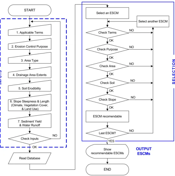
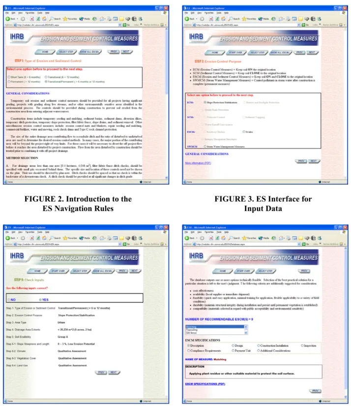
developed to ensure that the selected ESCMs take into account type and duration of erosion and sediment control (Figure 2), the erosion control purpose (Figure 3), and Iowa’s Midwest environment. The ES reviews user inputs (Figure 4) and suggests potential ESCMs for a particular situation. As well as, providing both general and detailed information on the technical elements involved in ESCM design and construction, inspection, maintenance, removal, economical considerations, and efficiency (Figure 5). The role of the ES is to identify that the appropriate methods for erosion and sediment control are used at each site, during and after construction.
END Check Terms Check Purpose Check Area Check Soil Check Slope Select an ESCM Last ESCM?
Select another ESCM
Show recommendable ESCMs OK OK OK OK OK YES NO NO NO NO NO NO ESCM recomendable OUTPUT ESCMs SE L E C T IO N START 1. Applicable Terms IN P U T S Read Database 2. Erosion Control Purpose
3. Area Type
4. Drainage Area Extents
5. Soil Erodibility
6. Slope Steepness & Length (Climate, Vegetation Cover,
& Land Use)
7. Sediment Yield & Water Runoff
Check Inputs OK
NO
FIGURE 2. Introduction to the ES Navigation Rules
FIGURE 3. ES Interface for Input Data
ESCM DATABASE DEVELOPMENT
The ES was developed as a PC-based format first (Phase I), followed by a Web-based version (Phase II). The ES interfaces were designed using Borland C++ Builder, Version 5.0 (Borland Software
Corporation). The ES database was organized using Paradox 7 (Corel Corporation). Phase II of the project was developed using ASP.Net using a source code elaborated with Visual Basic .Net (Microsoft Inc.). The following main features characterize the PC and World Wide Web based ES.
Phase I: PC based Version
1. Comprehensive simulation of the ESCM decision-making process: All technical elements involved in the selection of the control measures are incorporated in the ES (objectives, type, site evaluation, ESCM specifications). Permitting considerations relevant to selection of the ESCM are also included. 2. Multi-layered information: User interfaces for each requested input or output information are
contained by two or more layers: the first layer addresses general information valid for classes of ESCM, while the subsequent layers address details pertaining to specific factors or selected ESCM. Given the fact that field engineers are only occasionally implementing ESCMs, the terms of the interfaces are explained in plain language to accommodate various technical backgrounds.
3. Self-contained: The various levels of information make the ES a comprehensive source of information that does not need additional references to guide in the selection of the appropriate ESCM for a particular situation. When needed, the user is directed to additional sources of information regarding data collection, data interpretation, and evaluation.
4. Portability: The PC-based design of the ES assumes user access to PC. Each of the steps involved in the decision making process can be printed as hardcopy containing exclusively the specifications related to the ESCM of interest.
5. Compact format and efficient navigation: Use of the multi-layer structure allows minimization of the number of ES interfaces. Navigation rules are simple and straightforward, thereby enabling users to form queries, provide information, and efficiently interact with the ES. The ES prompts the user when input data are incomplete or the functions are not yet implemented in the engine.
6. Compact format and efficient navigation: Use of the multi-layer structure allows minimization of the number of ES interfaces. Navigation rules are simple and straightforward, thereby enabling users to form queries, provide information, and efficiently interact with the ES. The ES prompts the user when input data are incomplete or the functions are not yet implemented in the engine.
7. Flexibility: The design of the ES allows unlimited further development and upgrading of the database with minimum changes to the core ES elements.
8. Iowa specific: Though the information assembled in the ES is collected from various state DOTs and Iowa counties, priority was given to include ESCMs evidently best suited for Iowa and to rely in principal on the literature resources available in the state.
Phase II: World Wide Web Version
Phase I of the project has led to a convenient, PC-based ES for identifying and evaluating potentially effective ESCMs for use in roadway construction throughout Iowa and elsewhere in the Midwest. Given that this first version of the ES is PC-based and addresses limited user categories, we anticipated that the ES can be considerably enhanced by substantiating the level of detail in the knowledge database and by transitioning the developed application to a web-based platform. The objectives of a Phase II of the project have been accomplished through the following tasks:
1. Review the ES PC database: ensuring it includes IDOT in-house expertise in ESCMs. This step entails close collaboration with IDOT personnel to add specifications contained in Plan Notes, Special Provisions, Supplemental and Standard Specifications for each ESCM. During Phase I of
work, several sources were inaccessible to the project investigators (e.g., files in MicroStation format). Also, the available resources did not readily facilitate preparation of specific materials in electronic format (through scanning).
2. Implementing the quantitative assessment: the quantitative assessment part of the ES was not active following Phase I of the project. The addition of a inference engine for the quantitative assessment extends the functionality of the ES to additional user categories (e.g., design engineers, consultant engineers, etc)
3. Transitioning the ES from PC- to web-based platforms: The PC-based ES synthesized the available information on ESCMs, but it was not built using state-of-the-art information transfer technologies. By adapting the PC-based ES to the web-based environment it is possible to take advantage of important capabilities of the web-based tools, such as the following:
a. Centralized management of the ES knowledge base
b. Efficient and quick upgrading of the database (in matters of hours the database can include the latest updates deemed necessary and be ready for users).
c. Quick dissemination.
d. Avoidance of installation conflicts due to the variety of PC hardware and software e. Minimum maintenance
f. Efficient use of links to other relevant sources of information available on internet.
4. Training: including an instructor’s manual, and delivers training for users. The ES developed in the first phase of the project is in a simple format with user-friendly interfaces. However, training
sessions would be good opportunities to speed up product implementation/dissemination. Moreover, a training program could foster, through hands-on demonstrations and direct interaction with the users, further actions to enhance the functionality and content of the ES.
CONCLUSIONS
An extensive literature review on ESCMs revealed most of the available guidelines and instruction manuals for ESCM implementation are in conventional format. We’ve found that the hardcopy and compact disk manuals are not readily available for efficient use and requiring a familiarity with ESCMs in order for selection. The situation led the authors to initiate a simplified expert system that incorporates knowledge and inference rules derived by specialists in the field.
The paper demonstrates through Phase I of the project, we have successfully incorporated the literature review in a PC database platform. Phase II further evolved the ES’s input and output capabilities by transitioning the PC version of the database to a World Wide Web version.
The final WWW ES product is an efficient decision-making tool requiring minimum preparation, quite user-friendly, and beneficial by updating capabilities by the computer administration. The newly created erosion and sediment control measure database may be accessed virtually by any specialist, from Highway Construction Engineers to State Environmentalists. The ES potential can be used as a design tool in connection with environmental protection plans and part of a training program for specialized DOT personnel.
ACKNOWLEDGMENTS
The authors thank Mark Dunn, David Heer, Mark Mastellar, and Ole Skaar, Jr all of the Iowa Department of Transportation, as well as to Stacie Johnson from Chamness Technology, Inc and Vlad Muste of Cornell University for the Phase I contributions. Phase II could not have been completed without the continuous and thoughtful assistance of Mark Dunn of the Iowa Highway Research Board.
REFERENCES
1. Goldman, S.J., K. Jackson, and T.A. Bursztynsky. Erosion & Sediment Control Handbook. McGraw-Hill, Inc., New York, 1986.
2. Miller, G.A., M. Amemiya, R.W. Jolly, S.W. Melvin, and P.J. Nowak.. Soil Erosion and the Iowa Soil 2000 Program. Pm-1056. University Extension, Iowa State University, Ames Iowa, 1988. 3. Environmental Protection Agency. Storm Water Management for Construction Activities: Developing
Pollution Prevention Plans and Best Management Practices. Publication No. EPA-833-R-92-005. Environmental Protection Agency, Washington, D.C., 1992.
4. Muste, M, R. Ettema, and C. Mutel. Erosion Control for Highway Applications—Phase I: Review and Synthesis of Literature. Iowa Department of Transportation, Ames, Iowa, 2002.