INTENTION AND ACTION: PLAN AND POLICY IMPLEMENTATION FOR WATER RESOURCE PROTECTION
Danielle Laura Spurlock
A dissertation submitted to the faculty of the University of North Carolina at Chapel Hill in partial fulfillment of the requirements for the degree of Doctor of Philosophy in the
Department of City and Regional Planning
Chapel Hill 2015
Approved by: Philip R. Berke Lawrence E. Band
©2015
Danielle Laura Spurlock
ABSTRACT
Danielle Laura Spurlock: Intention and Action: Plan and Policy Implementation for Water Resource Protection
(Under the direction of Philip Berke)
Urban land development is one of the principal means through which human
activities alter water resources. An extensive body of research links land use to water quality outcomes, but these studies often do not account for how human behavior and institutional action shape urban land development. This gap in the planning scholarship offers an opportunity to examine the land development process and the policies aimed at protecting water quality.
Comprehensive plans, development management ordinances, and approved development applications help organize the land use development process. The translation of a plan and ordinances into action to protect water resources, however, cannot be assumed. This dissertation examines 1) the quality of policy inputs (i.e., comprehensive plans and ordinances); 2) the influence of mandates on the quality of policy inputs; and 3) the implementation of one key best management practice to protect water quality—riparian buffers.
riparian buffer policies were compared to development applications, which, in turn, were compared to high-resolution land cover classification maps to investigate policy slippage and implementation.
ACKNOWLEDGEMENTS
This dissertation is the product of love, labor, and faith. I would like to thank my committee for their guidance in the conception and execution of this research project. From my proposal defense to my dissertation defense, each of you suggested revisions, additions, and insights that enhanced the final project immeasurable. Thank you to Dr. Lawrence Band, Dr. Todd BenDor, Dr. Gary Henry, Dr. Nikhil Kaza (unofficial member) and Dr. Yan Song for your expertise, your time, and your kindness.
To Dr. Phil Berke. There is not enough space to express my gratitude to you for all of your support and care over these long years. You are the reason I returned to graduate school and your tutelage is the reason why I finished. You were the wind at my back during this entire process. Pushing me forward. Catching me when I fell. And finally lifting me up as I finished. I know I have the best mentor the planning world has to offer.
I would like to thank the following organizations and programs that helped fund this research: the Royster Society of Fellows, the UNC Institute for the Environment (Carolina Environmental Synthesis Program and Triangle ULTRA); the F. Stuart Chapin Jr. Fund; and the Lincoln Institute of Land Policy (C. Lowell Harriss Dissertation Fellowship). The
financial support of these organizations allowed me to devote myself fully to research, gave me access to data, and allowed me to hire the help I needed to complete this undertaking.
Avery Livengood, Carl Kolosna, Morgan Bettcher, Adam Carr, and Lillian Wu. Thank you for your dedication to the project demonstrated by your willingness to read thousands of pages of plans, ordinances, and development applications, your interest in the project’s goals, and your diligence in bending GIS to your will.
Thank you to my friends and colleagues in the doctoral program who took me in when I didn’t have a cohort, showed me how to navigate the program, read countless drafts and covered them in tracked changes, and provided invaluable and incisive critiques of papers and presentations with humor. To Tab Combs, Mary Donegan, Marc Howlett, and Ward Lyles. I am a better scholar because of each of you.
I would like to thank my friends who tolerating my incessant need to talk about all aspects of the project, forced me to leave it on the shelf and engage in frivolity, and celebrated with me when it was complete. To Tasseli McKay, Summer Alston, Fayola Jacobs, Adrienne Heller, Jessica Barron, Adina Black, Jackie Malik, Sarah Mayorga-Gallo, Candis Smith, and Rose Buckelew.
TABLE OF CONTENTS
LIST OF TABLES ... xiv
LIST OF FIGURES ... xvi
CHAPTER 1: WATER QUALITY, LAND USE & PLAN IMPLEMENTATION ... 1
1.1 Research Problem ... 1
1.1.1 Urbanization and Water Quality ... 3
1.2 Land Use Development Process ... 6
1.2.1 Comprehensive Plans ... 7
1.2.2 Development Management Ordinances ... 9
1.2.3 Approved Development Applications ... 10
1.2.4 Landscape Features ... 12
1.2.5 Land Use Policy Process, Policy Slippage, and Implementation ... 14
1.3 The Obstacles to Collective Action for Watershed Protection... 17
1.4 Planning Mandates ... 22
1.5 Purpose of Research ... 24
1.6 Research Questions ... 24
1.7 Conclusion ... 26
CHAPTER 2: EVALUATING PLAN IMPLEMENTATION ... 30
2.1 Introduction ... 30
2.2 What is Planning? ... 31
2.3 Evaluating the Public Planning Process ... 33
2.3.1 An Evaluation Logic Model for Land Use Development... 33
2.3.2 Barriers to Plan Implementation ... 36
2.3.3 Performance and Conformance-Based Definitions of Planning Success ... 36
2.4 Conceptual Model ... 40
2.4.1 Comprehensive and Plan Quality ... 43
2.4.2 Development Management Ordinances and Ordinance Quality ... 45
2.4.3 Approved Development Applications and Policy Slippage ... 49
2.4.4 Landscape Features and Implementation ... 52
2.5 Linking State Mandates to Better Land Use Outcomes ... 54
2.5.1 State Mandate Scope: Single Purpose versus Comprehensive Approaches ... 55
2.5.2 State Mandate Design: Impact on Implementation ... 56
2.5.3 Community and Project Variables ... 59
2.6 Hypotheses ... 61
2.8 Conclusion ... 63
CHAPTER 3: RESEARCH DESIGN & METHODS ... 65
3.2 Research Design ... 65
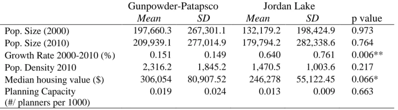
3.3 Site Selection ... 66
3.4 Watershed Profiles ... 70
3.4.1 Gunpowder-Patapsco Watershed in Maryland ... 71
3.4.2 Jordan Lake watershed in North Carolina ... 72
3.5 Demographic Comparisons ... 73
3.6 Data Collection and Analysis ... 77
3.6.1 Quality of Policy Input Analysis ... 77
3.6.2 Implementation of Riparian Buffer Policies ... 88
3.7 Threats to Validity ... 102
3.8 Conclusion ... 103
CHAPTER 4: MANDATE DESIGN ASSESSMENT ... 105
4.1 Introduction ... 105
4.2 State Policy Regime Profile ... 106
4.2.1 Maryland ... 106
4.3 Mandate Design ... 110
4.3.1 Comprehensive Planning Mandate ... 110
4.3.2 Environmental Sensitive Area Mandates ... 114
4.4 Conclusion ... 120
5.1 Introduction ... 122
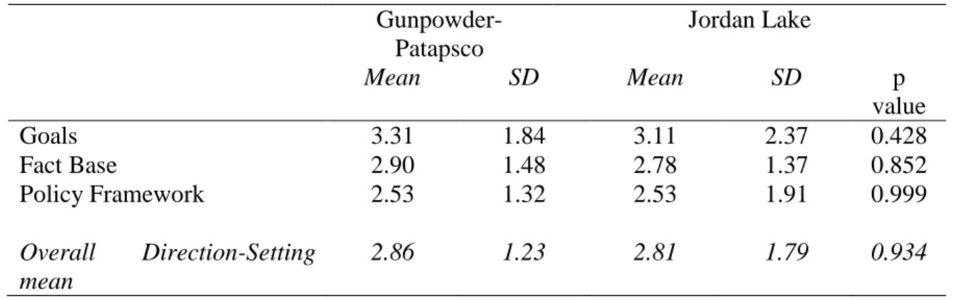
5.2 Direction-Setting Framework ... 124
5.2.1 Goals ... 125
5.2.2 Fact Base... 127
5.2.3 Policy Framework... 128
5.3 Action-Oriented Framework ... 130
5.3.1 Implementation ... 132
5.3.2 Monitoring ... 133
5.3.3 Inter-jurisdictional Coordination ... 135
5.3.4 Participation ... 137
5.4 Conclusion ... 139
CHAPTER 6: ORDINANCE QUALITY RESULTS... 142
6.1 Introduction ... 142
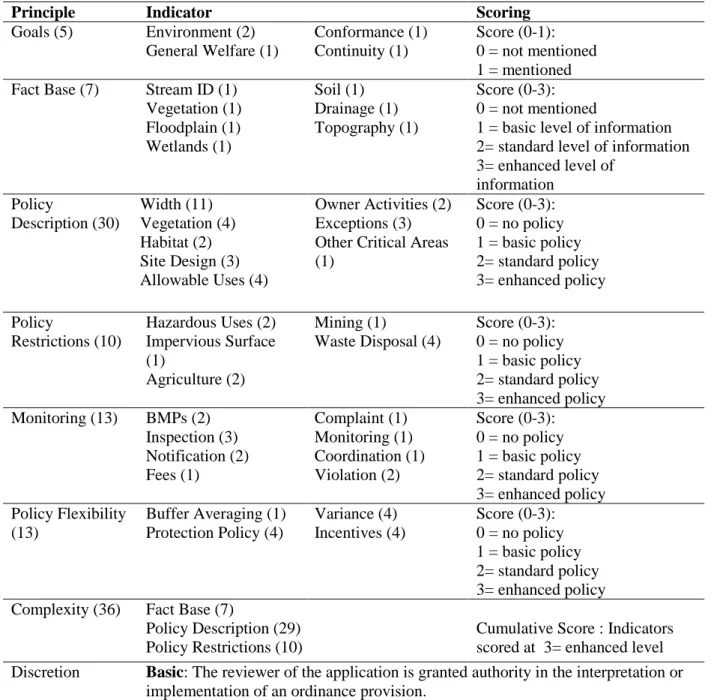
6.2 Policy Content Framework ... 145
6.2.1 Goals ... 146
6.2.2 Fact Base... 148
6.2.3 Policy Description ... 150
6.2.4 Policy Restrictions ... 152
6.3 Administration Framework ... 154
6.3.2 Policy Flexibility ... 156
6.3.3 Complexity ... 158
6.3.4 Discretion... 159
6.4 Conclusion ... 162
CHAPTER 7: PREDICTING POLICY SLIPPAGE AND THE IMPLEMENTATION OF RIPARIAN BUFFER POLICIES ... 165
7.1 Introduction ... 165
7.2 Policy Slippage ... 166
7.3 Implementation ... 169
7.3.1 Predicting Bare Earth within Riparian Buffers... 173
7.3.2 Predicting Tree Cover within Riparian Buffers ... 178
7.3.3 Predicting Impervious Surface in Riparian Buffers ... 184
7.4 Conclusion ... 190
CHAPTER 8: STUDY IMPLICATIONS AND FUTURE RESEARCH ... 193
8.1 Introduction ... 193
8.2 Hypotheses Revisited ... 195
8.2.1 Plan and Ordinance Quality ... 195
8.2.1 Policy Slippage ... 197
8.2.3 Implementation ... 199
APPENDIX A: PLAN QUALITY PROTOCOL ... 206
APPENDIX B: ORDINANCE QUALITY PROTOCOL... 233
APPENDIX C: LAND COVER CLASSIFICATION MAP MEASUREMENTS... 255
LIST OF TABLES
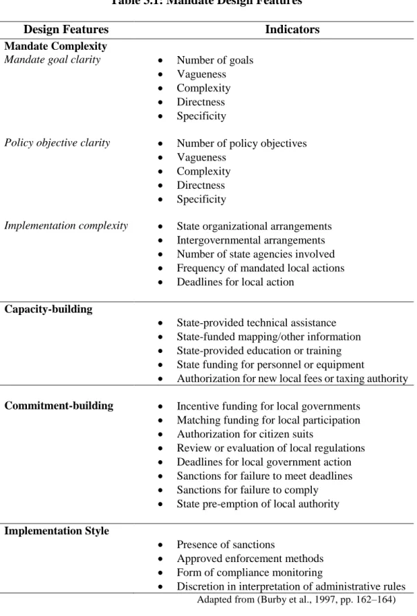
Table 3.1: Mandate Design Features ... 68
Table 3.2: Watershed Demographic Characteristics ... 74
Table 3.3: Demographic Characteristics by Watershed ... 75
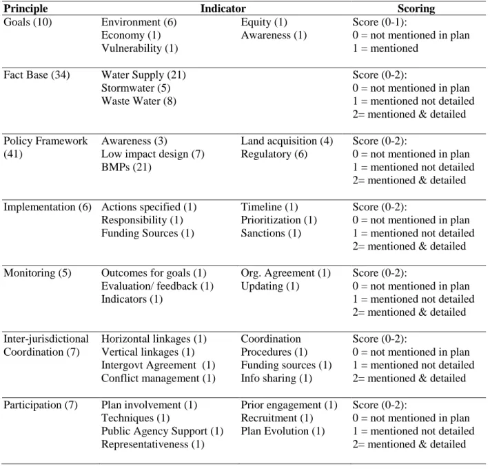
Table 3.3: Plan Quality Indicators and Scoring by Principle... 81
Table 3.4: Ordinance Quality Indicators and Scoring by Principle ... 84
Table 3.5: Plan Quality- Fact Base Indicator Description ... 86
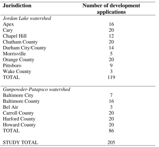
Table 3.6: Number of Development Applications by Jurisdiction ... 91
Table 3.7: Land Cover Class ... 93
Table 3.8: Policy Slippage Indicators by Principle ... 95
Table 3.9: Implementation Variables ... 97
Table 3.10: Summary of Study Variables ... 101
Table 4.1: Design Feature Scores for Maryland Comprehensive Planning Mandate ... 111
Table 4.2: Design Feature Scores for Environmental Sensitive Area Mandates ... 115
Table 5.1: Direction-Setting Principle Scores by Watershed ... 124
Table 5.2: Action-Oriented Principle Scores by Watershed ... 131
Table 6.1: Policy Content Principle Scores by Watershed ... 145
Table 6.2: Ordinance Quality Principle Scores by Watershed ... 154
Table 6.3: Frequency of Discretion by Principle by Watershed ... 160
Table 7.1: Policy Slippage by Jurisdiction ... 167
Table 7.2: Descriptive Statistics for Dependent and Independent Variables ... 171
Table 7.4: Predicting the Percentage of Bare Earth within Approved Buffer ... 175
Table 7.5: Descriptive Statistics for Tree Cover Scores by Watershed ... 179
Table 7.6: Predicting the Percentage of Tree Cover within Approved Buffer ... 180
Table 7.7: Descriptive Statistics for Impervious Surface Scores by Watershed ... 185
LIST OF FIGURES
Figure 1.1: Land Use Policy Process ... 7
Figure 1.2: Illustration of a Riparian Buffer ... 13
Figure 2.1: Traditional Evaluation Logic Model ... 33
Figure 2.2: Adapted Evaluation Logic Model for Land Use Development ... 34
Figure 2.3: Conceptual Model ... 42
Figure 5.1: Number of Jurisdictions by Goal and by Watershed ... 126
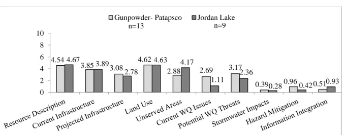
Figure 5.2: Mean Score by Fact Base Topic Area by Watershed ... 127
Figure 5.3: Mean Score by Policy Framework Topic Area by Watershed ... 129
Figure 5.4: Number of Jurisdictions by Implementation Indicator and by Watershed ... 132
Figure 5.5: Number of Jurisdictions by Monitoring Indicator and by Watershed ... 134
Figure 5.6: Number of Jurisdictions by Coordination Indicator and by Watershed ... 136
Figure 5.7: Number of Jurisdictions by Participation Indicator and by Watershed... 138
Figure 6.1: Number of Jurisdictions by Goal and by Watershed ... 146
Figure 6.2: Number of Jurisdictions by Fact Base Indicator and by Watershed ... 148
Figure 6.3: Mean Score by Policy Description Topic Area by Watershed ... 150
Figure 6.4: Mean Score by Policy Restriction Topic Areas by Watershed ... 153
Figure 6.5: Mean Score by Monitoring and Enforcement Topic Area by Watershed ... 155
Figure 6.6: Mean Score by Policy Flexibility Topic Area by Watershed ... 157
Figure 7.1 Predicted Probability for Bare Earth by Action-Oriented and Watershed ... 177
Figure 7.2 Predicted Probability for Tree Cover by Direction-Setting and Watershed ... 182
CHAPTER 1: WATER QUALITY, LAND USE & PLAN IMPLEMENTATION
1.1 Research Problem
Only an estimated 2.5% of all water on Earth is freshwater. Of that 2.5%, 68.6% is sequestered in glaciers and permanent icecaps while about 30.1% is groundwater. Of the remaining 1.3% freshwater, approximately 73% resides as ice and snow while 21% takes the form of surface freshwater resources such as lakes and rivers (Hornberger, Raffensperger, Wiberg, & Eshleman, 1998)1. It is from this limited amount of available freshwater that human populations fulfill critical biological, economic, and social needs.
The average person requires about 20-50 liters of water to meet their daily basic drinking, hygiene, and cooking needs (World Water Assessment Programme, 2009). Globally, diarrhea remains the leading cause of illness and death, but worldwide mortality from diseases such as cholera has been significantly reduced through the provision of clean water and sanitation facilities (UNICEF and World Health Organization, 2012). During the early twentieth century in the United States, the efforts of the nascent field of planning contributed to the reduction of infant, child, and total mortality through the provision of potable water and sanitation infrastructure (Cutler & Miller, 2005; Perdue, Gostin, & Stone, 2003). Sanitation engineers guided key alterations to the urban built environment such as the construction of citywide sewer infrastructure that worked in conjunction with natural
drainage contours (Peterson, 1979). Additionally, they were early advocates for the
systematic removal of refuse and animal waste from streets and the provision of potable water sources. These early engineering interventions to protect public health and safety were joined by regulatory uses of the state’s police power (i.e., the advent of zoning in the U.S.). Regulatory authority based on police power is an essential component of present day efforts to safeguard human and environmental health by the field of planning, and is the focus of this dissertation.
The “reserved powers” of states granted under the 10th amendment of the United
States Constitution provide the legal foundation for planning’s use of police power (“The Constitution of the United States of America,” 1791). Using its police power, a state may create, enact, and enforce regulations to protect “the health, safety, morals, and general welfare” of its citizenry (Burke, 2002). In order for local jurisdictions to have this authority, a state must delegate that power to jurisdictions, an action known as Dillon’s rule.2 For
example, the Department of Commerce streamlined the delegation of zoning authority from states to local jurisdictions by composing the 1926 Standard State Zoning Enabling Act (Department of Commerce, 1926). This Act preceded the 1928 Standard City Planning Enabling Act, which recommended the establishment of a permanent planning branch within local government and outlined the contents of a master plan (Department of Commerce, 1928). The language3 within the Standard State Zoning Enabling Act is imprecise with respect to the linkage between zoning and plans and the judicial record on this relationship is unclear (Mandelker, 1976). Thus, the ambitious original purpose of the master plan (or
2 Dillon’s rule is the rule of delegation of authority named for the 19th century judge who first used the formulation (Burke, 2002).
comprehensive plan)4— a statement of ‘willful intention’ to quote Kent—is separated from action, forever complicating the relationship between the comprehensive plan and the regulatory tools necessary to implement it (1991). This dissertation explores the creation of comprehensive plans and development management ordinances with respect to the protection of water resources and how local governments utilize these policy inputs within the land use decision-making process.
1.1.1 Urbanization and Water Quality
Historically, surface water resources heavily influenced the location of human settlements with the “25 largest cities, the 25 largest production locations, the 25 most prosperous areas and the 25 most densely populated areas in the world” all found near water bodies (World Water Assessment Programme, 2009, p. 120). Proximity to these water bodies was critical for the development and prosperity of human settlements, but a host of
environmental costs can accompany the utilization of these resources. For example, the damming of a river to provide a more permanent, drought-resistant water supply alters the depth, temperature, and light available to aquatic habitats. The dam may also serve as a source of hydroelectric power while reducing the amount of sediment downstream, which can contribute to the erosion of aquatic environments like deltas. In another example, urban and suburban developments often exist on former wetlands that were drained to enable construction and result in the impingement of sprawling development on
sensitive areas. This type of construction and other land use patterns associated with
urbanization are particularly concerning as the loss of natural areas alters the absorption and natural filtration of stormwater.
Stormwater runoff, rainwater that fails to be absorbed, affects water quality through two pathways: natural and anthropogenic. The natural pathway involve factors such as
topography (e.g., steep slopes), the hydraulic conductivity of different soil types, geology, the amount and density of vegetation cover, precipitation intensity and amount, and river
discharge (Baker, 2003; Hornberger et al., 1998). The anthropogenic pathway consists of human activities that change the built environment, increase the amount of stormwater runoff generated, introduce pollutants into stormwater runoff, and alter its progression through the environment.
Urban land development is one of the principal means through which human activities alter the amount and progression of stormwater runoff. The construction of residential, governmental, institutional, commercial, and industrial buildings as well as the creation of an extensive paved road system increases the amount of impervious surface, which, in turn, impedes the absorption of rainwater by blocking direct contact with
permeable surfaces. Haphazard urban development within the United States converted vast expanses of undeveloped greenfield areas into unprecedented amounts of impervious surface (i.e., paved roads, rooftops, and parking lots). Arnold and Gibbons argue impervious surface is a “quantifiable land use indicator correlated with water quality” (1996, p. 245)5. In many
urban areas, the drainage system developed to manage the stormwater generated from
impervious surfaces focused on “minimiz[ing] storage and maximiz[ing] conveyance” (Hey, 2001, p. 3). As a result, stormwater runoff is rapidly directed away from development to limit flooding. Unfortunately, the swift, unencumbered return to surface water resources reduces the amount of time natural processes can filtered out pollutants (i.e., heavy metals, synthetic chemicals, nutrients, sediment, and microbes). Focusing on urban development offers an opportunity to investigate the processes that govern the creation of the built environment while examining policies aimed at protecting water quality.
institutions and policies that help shape the observed urban form and if land use policies are implemented in accordance to plans and ordinances. The next two sections of this chapter provide an overview of the land use development process and explore the barriers to collective action for water resource protection.
1.2 Land Use Development Process
Planning can be divided into a number of sub-disciplines (e.g., land use,
transportation, housing and community development, real estate development, economic development) with direct influence on the urbanized built environment. Land use planning shapes the utilization of land within and adjacent to human settlements by directing the allocations of various land uses (e.g., agricultural, residential, commercial, institutional, and industrial) and the spatial arrangement of these uses (Berke, Godschalk, Kaiser, &
Rodriguez, 2006). This broad definition of land use planning encompasses the policies that help direct the type, use, density, and spatial arrangement of structures within the built and natural environments and the sociopolitical institutions that develop and enforce these policies. Although urban land development is a clear contributor to declining water quality, few research projects evaluate the implementation of the land use policies aimed at
protecting water quality.
process introduced in subsequent sections and is examined in depth in Chapter 2 as part of the project’s conceptual model.
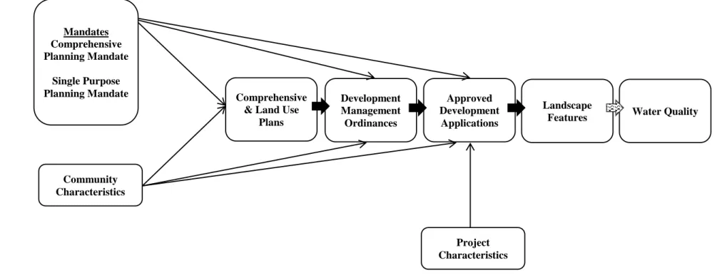
Figure 1.1: Land Use Policy Process
1.2.1 Comprehensive Plans
Comprehensive plans are key policy documents that should provide the overarching framework of goals, objectives, and policies that guide future development. Local
comprehensive plans are critical tools as they offer an opportunity to 1) assemble information about the current state of the community, 2) create projections and estimates for the future, 3) evaluate alternative courses of action, and 4) reconcile competing objectives (Berke,
Godschalk, et al., 2006). For example, the creation of a comprehensive plan offers an opportunity to assemble information about future water use projections and current threats to water quality such as nonpoint source pollution. Further, the planning process can help reconcile competing objectives like increasing a jurisdiction’s economic tax base while maintaining low-density development in environmentally sensitive portions of watersheds.
A subset of planning research links better quality comprehensive plans with better implementation and outcomes (Berke, Backhurst, et al., 2006; Brody & Highfield, 2005; Burby et al., 1997; Nelson & French, 2002). A high quality comprehensive or land use plan is one that incorporates the “highest quality of thought and practice” in the plan’s goals, fact
Water Quality Comprehensive
Plans
Development Management Ordinances
Approved Development
Applications
base and policy framework, which should help a community adapt to changing conditions while providing a structured vision of how a community wants to develop in the future (Berke & Godschalk, 2009, p. 228). Additionally, a high quality plan should include information and policies to facilitate the implementation and monitoring of plan goals.
A number of planning scholars contributed to the creation of a set of principles aimed at differentiating plans based on their quality (Baer, 1997; Berke, Godschalk, et al., 2006; Berke & Godschalk, 2009; Kaiser & Davies, 1999; Kaiser, Godschalk, & Chapin, 1995). Despite the central role water resources play in the functioning of urbanized areas, there is paucity of evaluations that examine the incorporation of water resource protection into comprehensive plans. Currently, only two studies adapt these principles to measure the quality of plans with respect to watershed and ecosystem protection (Berke, Spurlock, Hess, & Band, 2013; Brody, Highfield, & Carrasco, 2004). An assessment of ecosystem
management efforts within comprehensive plans in southern Florida found low plan quality scores even with a federal program aimed at restoring the Everglades, a state watershed management program, and a mandate for local comprehensive planning (Brody et al., 2004). Berke, Spurlock, and colleagues evaluated comprehensive plans in a portion of the Jordan Lake watershed in North Carolina and found few water quality protection goals, less detailed information about local water resources, and a limited number of policies aimed at protecting water resources (2013). This study builds on these prior research efforts by 1) assessing the quality of comprehensive plans with respect to the protection of water resources and
1.2.2 Development Management Ordinances
Development management ordinances contain the specific standards that govern the location and design of development and describe the review procedures necessary to gain approval. They can take the form of legislative, regulatory, incentive, and investment tools; offer specificity about acceptable actions during the development review process; and outline the requirements for the type, design, and location of constructed development. In short, ordinances represent a link between the goals, information, and policies contained within plans and approved development.
A few studies explore the role of ordinances in implementation (Hill, Dorfman, & Kramer, 2010; McPherson, 2001; Norton, 2008). These studies suggest compliance with ordinances is not consistent, the content of codes can differ based on spatial characteristics, and content can be associated with different implementation outcomes. There is also a limited body of work focusing on water quality and ordinances. A group of law professors proposed a Model Water Code in the early 1970s, which was followed by a Model
Stormwater Control Ordinance in the 1980s and a follow-up study of the ordinance’s
adoption in Florida (Ausness, 1987; Maloney, Ausness, & Morris, 1972; Maloney, Hamann, & Canter, 1980). In 2004, the American Society of Civil Engineers (ASCE) released a Regulated Riparian Model Water Code (American Society of Civil Engineers & Engineers, 2004). There are, however, no studies that examine the quality of development management ordinances.
the research literature does not include references to ordinance quality principles similar to the principles developed for plan quality, there are two recent studies that investigate
ordinances using content analysis. Norton’s examination of zoning codes for 32 jurisdictions within a Michigan county measured the amount of policy focus within ordinances on neo-traditional landscapes (2008). Stevens and Hanschka investigated whether recently adopted flood bylaws are consistent with government guidelines and the best practices in flood risk management (2014). This study builds on these previous studies by creating a set of
principles for ordinance quality that draw on the plan quality research literature, the theory of street-level bureaucracy, and practitioner resources. Similarly to both studies, I use content analysis to investigate the consistency of jurisdictional regulations with best practices around water resource protection. Development management ordinances are an understudied portion of the land development process and this study investigates the important connection
between comprehensive plans and land use outcomes.
1.2.3 Approved Development Applications
applications is an important step in the land use policy process with implications for the implementation of comprehensive plans and development management ordinances.
There is a growing body of research that utilizes approved development applications to study plan implementation. Higher quality plans have been linked with the implementation of plan policies using development applications and studies suggest the monitoring and enforcement style articulated in development ordinances can affect compliance (Brody & Highfield, 2005; Burby, May, & Paterson, 1998; Burby, 2003; Laurian, Day, Backhurst, et al., 2004). A number of studies of development applications found elements of the
development review process such as flexibility, complexity, and resources are key
components affecting compliance with plans and ordinances (Alterman & Hill, 1978; Burby et al., 1998; Laurian, Day, Backhurst, et al., 2004). While there are conflicting conclusions about the influence of developer characteristics and agency capacity on the implementation of approved development applications, market influences and the scale of the development are consistent factors affecting implementation (Alterman & Hill, 1978; Berke, Backhurst, et al., 2006; Burby et al., 1998).
the policies contained in development management ordinances and the development actually approved by the planning staff.
1.2.4 Landscape Features
The term landscape features refers to the land, water, vegetation, structures, and infrastructure that compose a landscape. Riparian buffers are “vegetated zones adjacent to streams and wetlands that represent a best management practice (BMP)” to help address issues around the quantity and quality of stormwater runoff (Mayer, Reynolds, Canfield, & McCutchen, 2005, p. iv). Figure 1.2 illustrates the role of riparian buffers in the filtration of pollutants, stream temperature regulation, and the reduction of runoff velocity; all of which have implications for erosion and runoff absorption. Buffers also offer benefits associated with flood control, stream bank stabilization, and can protect aquatic and terrestrial habitats.
Riparian buffers were selected as the focus of this research because of 1) the well-defined linkage between riparian buffers and water quality, 2) the extensive scientific literature on design characteristics to optimize riparian buffer functioning, and 3) the widespread adoption of riparian buffer policies by jurisdictions (Booth & Keinfelt, 1993; Griffin, 1980; Klein, 1979; Lowrance et al., 1997; Mayer et al., 2005; Phillips, 1989;
Schueler, 1994; Todd, 1989; Vidon & Hill, 2004). The focus on riparian buffers allows for an examination of a diverse set of regulatory, incentive, and acquisition policies within
and/or low impact design (i.e., infill, conservation development, green building, green site and street design).
Figure 1.2: Illustration of a Riparian Buffer
A number of studies explore the connection between planning inputs and changes to landscape features. Talen’s 1996 study investigates whether park facilities in a 1966 plan were actually developed and located according to the plan using spatial analysis (1996a). Loh used Geographic Information Systems (GIS) to investigate whether instances of
nonconformity with plans were artifacts of the land development process or decisions made in direct contradiction to the plan (2011). Chapin and colleagues also used GIS to conduct a parcel level assessment of land use changes, which allowed for the examination of the relationship between comprehensive plan approval and land use changes (Chapin et al., 2008). Ozawa and Yeakley investigated the loss of riparian vegetation under three different development policies using high-resolution land cover classification maps (2007). Each of these studies investigated alterations to landscape features and offer an essential refinement
to implementation studies—the comparison of planning inputs to on-the-ground conditions. This study utilizes GIS and high-resolution land cover classification maps to examine the implementation of riparian buffers (i.e., width, vegetation, and impervious surface
encroachment) for approved developments.
1.2.5 Land Use Policy Process, Policy Slippage, and Implementation
The translation of a plan into action cannot be assumed. The failure to implement plans is a long-standing critique of the planning process and many plans languish on a shelf despite the considerable expenditure of time and resources necessary for their creation. In a scathing criticism of planning in general (and comprehensive planning in particular), Altshuler questioned the utility of a ‘comprehensive’ plan and its ability to guide decision-making given the limitations on planners’ power within the political arena (1965a, 1965b). Clawson’s criticisms of planning focus on the disjointed implementation of plans although he acknowledges the complexity introduced by the dense network of stakeholders with disparate motivations involved in plan implementation (1971). Wheaton (1969), Hall (1980), and Alexander and Faludi (1989) point out the uncertainty and fallibility of planner judgments, which necessitates the review and verification of their actions.
Recent empirical research identify contextual factors that complicate implementation efforts such as the complexity of the planning decision-making process, the political
use outcomes: 1) plan conception, 2) plan writing, 3) conversion from plan to ordinances, and 4) ordinance enforcement (2012). Loh refers to these points as “disconnects”, but this research will use the term “slippage” as used in the implementation literature (Berman, 1978; Farber, 1999; Pressman & Wildavsky, 1973). Slippage refers to deviations or differences between a stated policy or objective and the actual actions taken and/or outcomes. This dissertation focuses on two potential slippage points during ordinance enforcement: application approval and constructed development.
Farber divides policy slippage into two categories: negative and affirmative slippage (1999). Negative slippage refers to the failure to implement without prior authorization. Affirmative slippage is associated with deviations from policy that are openly renegotiated. These two conceptualizations of policy slippage parallel two common approaches to plan evaluation: conformance and performance approaches. Conformance-based evaluation uses a definition of success based on the agreement between the intentions expressed in plan and what is actually implemented. It is analogous to negative policy slippage where any deviation from planning inputs is considered noncompliance. The main strengths of this approach are the clear-cut linkages between planning and action and straightforward metrics for
measurement. However, scholars such as Baer raise concerns about determining success or failure based solely on departures from an intended plan because departures are inevitable as plans alone are not sufficient for implementation (i.e., factors like politics matter) and the circumstances surrounding decisions shift (1997).
Alexander and Faludi6 define a performance-based approach to evaluation as the examination “of the policy or plan as a frame of reference for operational decisions" (1989,
p. 134). For example, a plan might be considered implemented if it were simply consulted during the development process. Though this definition accounts for uncertainty by allowing flexibility in the use of a plan, successful implementation of the plan is difficult to measure.
This project combines conformance- and performance-based approaches. The conformance-based element includes the creation of scoring protocols to reduce the
subjectivity of measures while determining the agreement among plan policies, ordinances, and applications (i.e., negative policy slippage) (Alexander & Faludi, 1989; Berke,
Godschalk, et al., 2006; Brody, Carrasco, & Highfield, 2006; Laurian, Day, Berke, et al., 2004). The performance-based approach focuses on the operational decisions of planners and development applicants to capture the rationales provided to explain departures from
ordinance provisions (i.e., affirmative policy slippage) using content analysis of approved development applications (Forester, 1993; Talen, 1997).
This project is the first single study to investigate the entire land use policy process from comprehensive plans through development management ordinances to approved and constructed development. It contributes to the research literature by applying plan quality principles to the protection of water resources and creating ordinance quality principles to examine an essential but understudied portion of the land development process. The use of GIS and high resolution land cover classification maps places this project among a small number of projects linking policy inputs to actual alterations to landscape features. Finally, the review of the full land use policy process allows for the identification of multiple policy slippage points throughout the development process.
slippage points highlighted by past implementation studies, there are three factors that make organizing collective action to protect water resources particularly difficult: growth pressures on individual local governments, the spatial mismatch between watershed and jurisdictional boundaries, and the nature of nonpoint pollution. The following sections review the obstacles faced by local governments seeking to take action to protect water resources and explores one common policy intervention used to address these barriers: mandates.
1.3 The Obstacles to Collective Action for Watershed Protection
Land use decisions by individual local governments can have clear economic benefits as jurisdictions can increase their tax base through development (Berke, Godschalk, et al., 2006; Hopkins, 2001). Beyond the possible economic benefits associated with individual land use decisions, Molotch’s work on the urban growth machine suggests that growth (and the accompanying land use development) serves as a motivation for a variety of stakeholders within urban areas and contributes to fierce competition for growth7 at the regional scale (Molotch, 1976).
Each locality, in striving to make these gains, is in competition with other localities because the degree of growth, at least at any given moment, is finite. The scarcity of developmental resources means that government becomes the arena in which land-use interest groups compete for public money and attempt to mold those decisions which will determine the land-use outcomes. Localities thus compete with one another to gain the preconditions of growth (ibid, p. 312).
Although the actual benefits of growth remain disputed, its perceived benefits factor into the development pressures placed on local jurisdictions and the motivations underlying land use decisions. Individual jurisdictions benefit not only from actual constructed
development, but also from the creation of a favorable business climate that enables a jurisdiction to compete with neighboring jurisdictions for growth (ibid, p. 312). Thus, there are short-term economic benefits of growth as well as longer term reputational benefits, and these benefits do not necessarily account for growth-related problems such as traffic
congestion, air pollution, and water pollution (Feagin, 1988). Using the concept of the
tragedy of the commons as a reference point, water resources represent a commons8 degraded in favor of the benefits of growth and its associated land use development. The individual benefits from producing pollution outstrip the individual’s share of the collective costs of polluting (Hardin, 1968). Developers profit from land use decisions with minimum delays while local governments are often competing with other jurisdictions to attract development and expand their tax base (Logan & Molotch, 1987; Molotch, 1976). Development in an environmental protective manner is a longer term goal with a more diffuse set of positive consequences that must compete with a jurisdiction’s more immediate financial interest and benefits.
Nonpoint source water pollution provides an even more complicated illustration of the complexities surrounding common pool resources by adding two issues of scale that
affect the collective sharing of costs: the spatial mismatch between jurisdictional and watershed boundaries and the definition of nonpoint source pollution. Water pollution is a clear cost. As described above, the continued functioning of human settlements is dependent upon water resources and the degradation of water resources negatively affects their use for drinking water, recreation, and sustenance. Local jurisdictional boundaries rarely, however, correspond with watershed boundaries (Dunne & Leopold, 1978). While watershed
boundaries are determined by hydrological principles, the administrative boundaries of jurisdictions reflect historical, social, political, and economic forces in addition to the influences of the physical environment (United States Geographic Survey, 2013). This spatial mismatch results in a further attenuation of individual costs as the number of
stakeholders responsible for a single body of water increases9. Not only do the benefits to an individual polluter outweigh their share of the collective costs of degrading a resource, but there is the possibility that costs are borne by a completely different set of jurisdictions.
Sources of nonpoint pollution are, by definition, difficult to identify and pinpoint in space, which impedes individual jurisdictions from assuming the true cost of degradation. Local jurisdictions must weigh the benefits associated with land use development patterns consistent with the urban growth machine against a shared portion of collective costs that may or may not directly impact their water resources. For example, it may be in the ‘rational’ self-interest of an individual jurisdiction not to require more expensive construction practices around tree preservation or grading because the cost of sedimentation in a local waterway is borne by multiple jurisdictions (Hardin, 1968).
9 The difference in boundaries is accompanied by a difference in scale. Though there will likely be a number of smaller watersheds within a local jurisdiction, the aggregation of these smaller watersheds into larger
Federal legislation is one mechanism to overcome barriers to collective action. Section 303(e) of the Clean Water Act requires states to establish and maintain a continuing planning process to monitor, maintain, and improve the water quality. States, in turn, must work with local jurisdictions using both regulatory and non-regulatory means to maintain water quality and restore impaired water bodies. There is, however, no comparable national legislative framework for land use although the federal government does intervene on a number of issues that directly and indirectly impact land management, (Burby & May, 1998). States are tasked with the protection of water quality, but many decisions governing a key contributing factor to water quality—land use—occur at the local level. As a result, local jurisdictions must work in partnership with state and federal governments to help remediate water quality issues, which fits the description of a “shared governance dilemma”.
Shared governance refers to occasions where “common or overlapping
responsibilities are apportioned among layers of government” (May & Williams, 1986). A shared governance dilemma can result from this particular governance structure when these layers of government must work in concert to achieve a particular goal, but the commitment and capacity of local governments to take actions that are in line with state goals and
water resources, there may still be limited local commitment (Burby & May, 1998). Jurisdictions can, in effect, free-ride on the efforts of other jurisdictions without taking comparable action. In a recent study of comprehensive plans, Berke, Spurlock and colleagues found that local governments utilizing a lake for drinking water included less water resource protection information and fewer policies in their comprehensive plans than jurisdictions within the same watershed that were not using the lake as a drinking water source (Berke et al., 2013). This type of free-riding in the management of a common pool resource is a widespread problem. Further, while isolated efforts by jurisdictions can
positively impact water quality, a regional approach is necessary to make substantial progress in the protection of water resources (Dunne & Leopold, 1978; Ostrom, 1990). Using
sedimentation as example, policies enacted to limit erosion by one jurisdiction can reduce the overall amount of sediment in a water body, but a sedimentation problem can persist if other jurisdictions within the same watershed fail to take action.
Capacity also affects a jurisdiction’s ability to coordinate the efforts of multiple agencies within a local government with neighboring jurisdictions.
In short, a number of land use policy interventions with the potential to help remediate water quality issues must take place at the local level. Local jurisdictions,
however, often lack the commitment to take protective action due to the economic benefits of the land use development process and spatial realities of water resource protection.
Additionally, the lack of capacity complicates water resource protection even if a jurisdiction is committed to implementation. In an attempt to address the barriers to collective action inherent in water resource protection, some states adopt planning mandates to address the shared governance dilemma described above. The following section introduces the research on mandates, planning policy inputs, and outcomes.
1.4 Planning Mandates
This study explores the use of a regulatory, full partnership approach10 to shared governance, most readily identifiable with mandates (Berke, 1998). Many states choose to use mandates to address the shared governance dilemma that results from the requirements of the Clean Water Act. For mandates to have their intended effect on local decisions, these legislative directives must influence action (i.e., alter plans, modify ordinances, and/or influence decision making). A considerable body of planning literature exists on the positive influence of state mandates on outcomes such as the quality of plans, the strength of
development management regulations, and planning outcomes like diverting development
from hazardous areas (Berke, Dixon, & Ericksen, 1997; Berke, Roenigk, Kaiser, & Burby, 1996; Berke & French, 1994; Berke, 1998; Brody, Highfield, & Thorton, 2006; Burby & May, 1998; Burby & Paterson, 1993; Burby, 2005; Burby et al., 1993, 1998; Dalton & Burby, 1994; Hoch, 2007a; May & Burby, 1996; May & Williams, 1986). Jurisdictions in states with mandates are more likely to have higher quality plans than jurisdictions in states without mandates (Berke & French, 1994; Berke et al., 1996; Burby, 2005; Burby et al., 1997; Dalton & Burby, 1994). Higher quality plans are, in turn, associated with stronger development regulations (Burby et al., 1997). Additionally, a limited number of studies found an association between mandates and better planning outcomes such as less development in hazardous areas and lower hazard losses (Burby, 2005; Dalton & Burby, 1994). This is the first study to investigate the impact of planning mandates on water resource protection by examining the quality of comprehensive plans and the quality of riparian buffer policies.
Mandates alone, however, are not a panacea for implementing land use planning goals. Although jurisdictions subject to planning mandates are more likely to adopt plans, these plans often only adhere to the minimum requirements of the law and fail to implement mandate provisions fully (Berke & Beatley, 1992; May & Birkland, 1994). Further, the improvement in the quality of plans, development regulations, and implementation is
comprehensive planning (Gunpowder-Patapsco watershed in Maryland) and one watershed is not (Jordan Lake watershed in North Carolina). These two watersheds are also subject to two different mandates aimed at protecting environmentally sensitive areas. The results of this research will help clarify the role of mandates in the protection of water resources through their influence on planning inputs.
1.5 Purpose of Research
Land use planning represents a societal investment that can help balance
environmental protection with economic development (Campbell, 1996; Hopkins, 2001). Comprehensive plans, development management ordinances, and approved development applications are at the nexus of land use development and water resource protection as they are the policy documents that govern landscape features (i.e., the land, water, vegetation, and structures that compose a landscape). This project seeks to contribute to the growing body of plan implementation literature by combining an examination of these policy inputs with observations from high-resolution land cover classification maps in order to evaluate the incorporation of water resource protection.
1.6 Research Questions
Comprehensive plans and development management ordinances are important policy inputs that reflect a community’s commitment to water resource protection and shape the development process. As key policy documents, comprehensive plans provide the
overarching framework of goals, objectives, and policies that should guide future
comprehensive plans and development management ordinances with respect to the protection of water resources while investigating the impact of mandates on these planning inputs. Two research questions guide the research into this objective.
RQ1: Do jurisdictions in a state with a mandate for comprehensive planning have higher quality comprehensive plans with respect to water resource protection than jurisdictions in a state without a mandate?
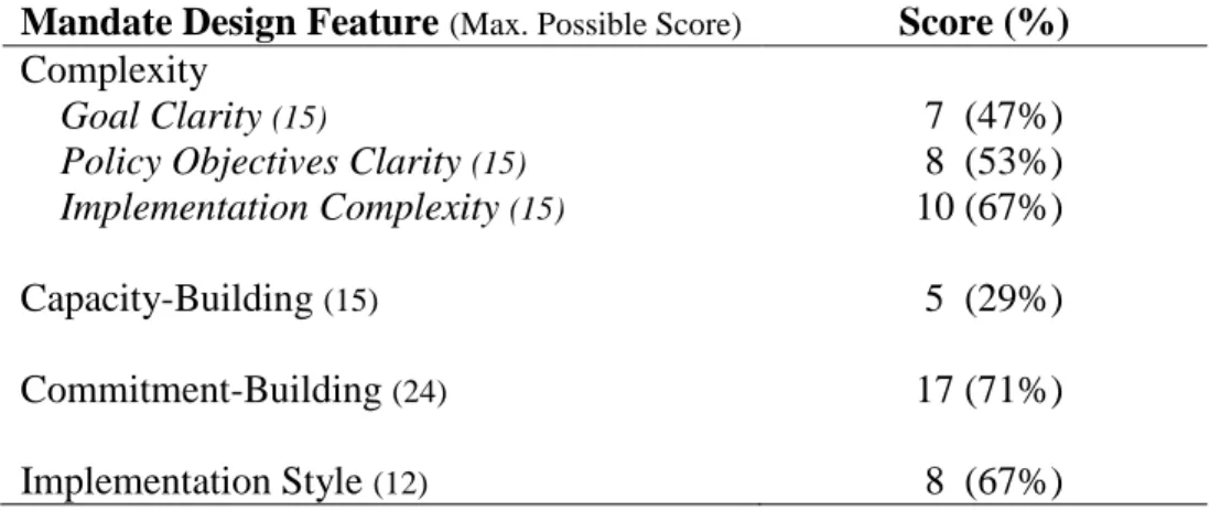
RQ2: Does the design of a single purpose state mandate (i.e., complexity, inclusion of capacity and commitment-building elements, and implementation style) adopted to protect environmentally sensitive areas affect the quality of buffer protection provisions within development management ordinances?
The second objective of this research is to investigate the implementation of a key land use policy aimed at protecting water resources—riparian buffer policies.
Implementation studies remain an underdeveloped area of research in planning. This research project investigates the implementation of ordinance policies by examining approved
development applications and constructed development. Slippage, the discrepancy between a stated policy and its actual implementation, can undermine effective strategies to protect water quality. This study measures slippage at two difference points: policy slippage and implementation. To measure policy slippage, the study compares the riparian buffer policies outlined in ordinances to the buffer provisions within approved development applications. To measure implementation, the study compares riparian buffer provisions within approved development applications to the buffers characteristics measured from high-resolution land cover classification maps. Three research questions guide this portion of the research project. RQ3: How frequently does policy slippage occur betweenthe riparian buffer policies
RQ4: Does the quality of policy inputs, the presence of mandates, and local context explain variation in policy slippage?
RQ5: Does the quality of policy inputs, the presence of mandates, and local context explain variation in implementation?
1.7 Conclusion
The indispensable roles played by water resources in human health and the establishment of human settlements should help to prioritize watershed protection. The multitude of stakeholders with differing valuations of environmental protection, however, can lead to conflicting problem definitions and goals for protection. Additionally, the economic motivations and spatial barriers associated with land use development complicate collective action to protect common pool resources.
and practitioners to synthesize new theories about the conditions that support and hinder plan implementation and inform practice and policy formulation at the local level.
1.8 Study Overview
Chapter 1 began by linking urbanization and water quality and identifying land use planning as a possible point of intervention to protect water resources. It introduced the key inputs in the land use policy process and the need to connect these inputs to implementation. Chapter 1 included a discussion of the spatial and economic barriers associated with the implementation of water resource protection policies along with the role of mandates can play in the development of higher quality planning inputs and implementation. The chapter concluded with the purpose of this study and the questions that guide the research.
Chapter 2 explores the concepts of intention, action, and outcomes within definitions of planning and how different definitions influence plan evaluation efforts. These concepts informed the adaption of an evaluation logic model as the basis of the project’s conceptual model. This model unites these concepts with the planning process for local land use
decisions first outlined in Figure 1.1. The chapter reviews each policy inputs associated with land use planning (i.e., comprehensive plans, development management ordinances, and approved development applications) with an emphasis on past research efforts. Additionally, it explores the influence of state policy, local social-economic factors, and site conditions on land use outcomes. The chapter concludes with the hypotheses tested in this study.
development applications; 3) measurements of riparian buffer composition from high-resolution land cover classification maps; and 4) the creation of regression models to test a series of hypotheses about the variables contributing to variation in policy implementation. The chapter concludes with a discussion of a potential threats to validity associated with the study.
Chapter 4 provides an assessment of the three mandates under study for this project: Maryland’s comprehensive planning mandate and single purpose mandates of both Maryland and North Carolina that seek to protect environmentally sensitive areas. The design features (i.e., complexity, capacity and commitment-building elements, and implementation style) of each mandate is characterized in order to allow a more nuanced examination of the influence of mandates on planning inputs and implementation in subsequent chapters.
Chapter 5 presents the results for the content analysis of the comprehensive plans. The plan quality protocol detailed in Chapter 3 is applied to comprehensive plans to determine their quality with respect to water resource protection. This chapter examines whether jurisdictions in a state with a comprehensive planning mandate have higher quality plans, on average, than jurisdictions in a state without a comprehensive planning mandate.
Chapter 6 examines the results from the content analysis of the development
management ordinances. This chapter differentiates between riparian buffer policies based on their quality using the ordinance quality protocol detailed in Chapter 3 and investigates whether the design of two different single-purpose mandates influence the quality of riparian buffer provisions within development management ordinances.
betweenthe riparian buffer policies outlined within development management ordinances and the provisions of approved development applications. The second portion of the chapter reports on a series of regression models created to test the implementation of riparian buffer policies. These models examine the factors that explain variation in the vegetative content and impervious surface encroachment of riparian buffers as observed from high resolution land cover classification maps.
Chapter 8 revisits the study hypotheses in order to integrate the various analyses completed for this dissertation. The chapter discusses both scholarly and practical
CHAPTER 2: EVALUATING PLAN IMPLEMENTATION
2.1 Introduction
Growth patterns over the past 50 years introduced unprecedented amounts of
impervious surface into the built environment with direct consequences for water quality. As communities face the continued deterioration of water resources, land use planning offers an essential point of intervention to protect watersheds. This chapter presents a theoretical framework for the evaluation of local land use planning efforts. I focus on two core tasks: 1) establishing the planning process for local land use decisions and 2) examining how state policy, local social-economic factors, and site conditions influence land use outcomes. This framework identifies factors affecting local governments’ efforts to protect water resources and slippage points in the implementation process.
The first section reviews several definitions of “planning” that emphasize the
barriers to collective action to protect common pool resources introduced in Chapter 1—the adoption of planning mandates. This section covers the research literature connecting planning mandates, the creation and quality of plans and policies, and implementation. The chapter concludes with the hypotheses that guide this research.
2.2 What is Planning?
Political scientist, Aaron Wildavsky asserts planning is “the attempt to control the consequences of our actions. The more consequences we control, the more we have
succeeded in planning. To use somewhat different language, planning is the ability to control the future by current acts" (Wildavsky, 1973, p. 128). In short, successful planning cannot just be an attempt to influence the future. There must be a discernible impact on the intended objective. Wildavsky is one of the first scholars to highlight the complexity that arises from defining planning as the extent of actual control rather than just an attempt to control the future (1973, p. 130). His incorporation of impact on outcomes into his definition led him to question the value of planning due to the constrained role of the planner in plan or policy implementation and difficulties arising from sociopolitical conditions.
Planning scholar Ernest Alexander acknowledges the complexity resulting from the emphasis on the “promise” of planning opposed to its “performance” (Alexander, 1981, p. 129). He does not, however, concede that achievement of success is dictated by outcomes only.
Alexander stresses planning is a deliberate activity focused on the future with an intention to implement a strategy to reach a particular outcome. Thus, planning is not just about a
measureable impact on the stated goal (outcomes), or the strategies and policies (action), but is also about the intention that guides the decision-making process. Planning theorist Charles Hoch echoes the emphasis on intention in his definition of planning by stating “Planning implies forethought and intention…. If we imagine planning as a kind of forethought, then the regular act of monitoring achievement means remembering the earlier intention as a framework for assessment” (Hoch, 2002). This planning definition is a crucial contribution to planning practice. By aligning the justification for planning with its monitoring, Hoch suggests planning practice must include evaluation11. Further, Hoch identifies planning documents as key planning inputs:
When we produce plan documents we expect people to read them and use the advice to inform and influence their own judgments about the allocation of public resources, the use of property and so forth. Implicit in such sincere and often urgent effort is the belief that planning will improve the quality of the judgments and that these improvements will produce more effective consequences on the use of resources, property or whatever. If we did not expect plans to make a useful difference, why would we make them? (Hoch, 2002).
The justification for planning is its potential to influence action and outcomes. Taken together, the work of Wildavsky, Alexander, and Hoch informs the conceptual framework introduced in the next section by identifying four key concepts: intention, action, outcomes,
and impact. Further, Hoch’s statements intertwining intention and plan documents help identify a starting point for the evaluation of intention in planning practice.
2.3 Evaluating the Public Planning Process
If planning implies intention, then the documents prepared as part of a planning process should reflect some measure of intention in written form (Hoch, 2002). Figure 1.1 in Chapter 1 illustrates the key documents of the land development process and their
hypothesized connection with landscape features and water quality outcomes. Although these documents do not capture or express the totality of intentions from the multitude of public and private stakeholders affected by a planning process, they do typify the public planning process (Hopkins, 2001).
2.3.1 An Evaluation Logic Model for Land Use Development
The evaluation logic model is a framework associated with program design, management, and assessment. In its simplified form, it depicts key program concepts and relationships to illustrate the underlying rationale for a program (W. Chen, Cato, & Rainford, 1999; Renger & Titcomb, 2002). Evaluation: Promise and Performance by Joseph Wholey is usually cited as the first publication to use the term "logic model" (1979). This model has since been informed by practitioners and evaluation scholars notably the Bennett hierarchy of evidence and the USAID Log Frame (Bennett, 1976; Solem, 1987; United States Agency for International Development, 2000).
Figure 2.1: Traditional Evaluation Logic Model
Impacts
The traditional model depicted in Figure 2.1 consists of four components: inputs, outputs, outcomes, and impact. Inputs refer to what is invested, the ingredients necessary for the system to do its work. Outputs are what is done, that is, the activities undertaken. Outcomes and Impacts are short and long-term changes and/or benefits that result from the program or policy. Figure 2.2 appends the policy inputs of the land use development introduced in Chapter 1 to the concepts of intention and action from the planning definitions forwarded by Wildavsky, Alexander, and Hoch (Alexander, 1981; Hoch, 2002; Wildavsky, 1973).
Although an evaluation logic model is often depicted in a linear form as in the figure above, Figure 2.2 includes a number of feedback loops to better capture the cyclic nature of policy implementation.
Figure 2.2: Adapted Evaluation Logic Model for Land Use Development
Comprehensive plans and ordinances are two key inputs that help govern the development process by spanning the transition from how a jurisdiction plans to develop (intention) to the detailed policies that will govern development (action). Comprehensive plans should provide the overarching framework to guide development. Thus, a
comprehensive plan is a suitable place to begin the measurement of a community’s intention. Comprehensive
& Land Use Plans
Development Management Ordinances
Approved Development
Applications
Landscape
Features Water Quality
Ordinances can be seen as the documents that operationalize the intention laid out in plans—a bridge between intention and action. Ordinances expound upon the intention articulated in plans and create the boundaries for acceptable action within the development process. The intention contained in comprehensive plans becomes more specific and actionable within ordinances making ordinances another opportunity to evaluate what we intend to do and how we plan to act. For example, a jurisdiction’s comprehensive plan may provide an overview of a stormwater best management practices (BMPs) policy to reduce the amount of runoff from new developments. The jurisdiction’s ordinance should add
specificity to that intention by outlining requirements for the placement, performance, and maintenance of stormwater BMPs.
Approved development applications are at the intersection between these planning inputs and action. Through the development review process, the intention contained in the written regulations, provisions, and incentives of ordinances is transformed into approved changes to the built environment. Approved development applications are the outputs of the development process that shape landscape features (i.e., the land, water, vegetation,
structures, and infrastructure that compose a landscape). Landscape features, in turn, affect the ultimate impact of interest for this research—water quality. As discussed in Chapter 1, the linkage between land use and water resources is well documented in the research literature (Alberti, 1999, 2005; Allan, 2004; Center for Watershed Protection, 1998;
2.3.2 Barriers to Plan Implementation
The previous section described the idealized pathway between key planning inputs and land use outcomes. There are, however, a number of barriers to plan and policy
implementation. Shifting sociopolitical circumstances within a community often necessitate modifications to plans and policies, and can diminish the connection between everyday decision-making and the proposed future conditions outlined in plans (Mazmanian &
Sabatier, 1983; Wildavsky, 1973). The lack of identifiable stakeholders (or publics) who are interested in particular policy can contribute to ineffective plan implementation as planners end up advocating for proposals that lack local support, trigger opposition, or are irrelevant to local conditions (Burby, 2003; Cobb & Elder, 1972). Finally, a fundamental barrier to
implementation is the heterogeneity of definitions of planning, which contributes to difficulty in defining what planning intends to do and what metrics should be used to determine
successful implementation. Talen states that defining planning as a process (i.e., “planning implementation”) calls for a different conception of success than a definition that
incorporates outcomes (i.e., “plan implementation”) (1996b). In response to this dilemma, this study opts for the outcome-focused definitions on planning covered in Section 2.2 and explores two approaches to evaluation to help define planning success.
2.3.3 Performance and Conformance-Based Definitions of Planning Success
observed outcomes and impacts. Alexander and Faludi12 describe the performance-based approach as the examination “of the policy or plan as a frame of reference for operational decisions" such that a plan might be considered successfully implemented if it helped guide the development process (1989, p. 134). Conformance-based evaluation focuses on
compliance or consistency with stated policies where implementation is successful if development outcomes closely match the plan.
In performance-based evaluative schemes, the plan is not seen as a blueprint, but as an advising tool where success may be signified by consultation of the plan in the decision-making process (Mastop & Faludi, 1997). The plan may influence action directly through following the plan or indirectly by influencing those who make the final decisions. This position is consistent with Innes’ discussion of the multiple ways that information can
influence action with more substantial action coming through indirect means (1998). Further, this method recognized uncertainty and makes provisions for departures from the plan if a valid rationale exists (Alexander & Faludi, 1989). The measurement of performance-based evaluation, however, is difficult and often reduced to consultation alone, which means success can be claimed any time the plan is referenced.
Dutch scholars produced the vast majority of the existing research literature on performance-based approaches to plan evaluation with the majority of the papers appearing in a single issue of Environment and Planning B (de Lange, Mastop, & Spit, 1997; Driessen, 1997; Mastop & Faludi, 1997; Mastop & Needham, 1997; Needham, Zwanikken, & Faludi, 1997; van Damme, Galle, Pen-Soetermeer, & Verdaas, 1997). A number of these studies establish the theoretical background of performance-based evaluation approaches and outline
future areas of research (Mastop & Faludi, 1997; Mastop & Needham, 1997). One study examined if the stakeholders charged with making plans were aware of discrepancies between plans and their implementation (Needham et al., 1997). The remaining papers undertake a performance-based evaluation of some aspect of the planning process. Driessen identifies a set of “policy games” used by a network of stakeholders to influence the
implementation of policies contained in spatial plans (Driessen, 1997). He suggested situational rationality and the interdependency between levels of stakeholders precludes a conformance approach (ibid). Another Dutch research team also argue against a
conformance-based approach in their study of national planning policies because they believe policies created at this level of government are usually strategic and less likely to have a direct influence on spatial organization (de Lange et al., 1997).
More recent additions to the performance-based evaluation literature continue to clarify how performance evaluation could take place (Faludi, 2000, 2006). While the existing literature on performance-based evaluation rightly focuses attention on uncertainty and the necessity of allowing flexibility in the use of a plan, successful implementation is difficult to measure using this definition and “no fully fledged performance study has been completed” (Mastop & Faludi, 1997).
articulate their role (Alterman & Hill, 1978; Baer, 1997; Calkins, 1979; Laurian, Day, Berke, et al., 2004; Talen, 1996b, 1997). Talen argues that although the level of control attributed to planners by a conformance-based approach is greatly disputed in theory and practice, the profession must retain some desire for direct influence on planning outcomes (1997). The main drawbacks of this approach are its inflexibility, which conflicts with the uncertainty inherent in planning for future conditions. Baer argues a departure from the plan should not, in and of itself, be deemed a failure (1997). Departures are inevitable because plans alone are not sufficient for implementation and the circumstances surrounding decisions shift.
This project combines elements from conformance- and performance-based