MADE IN AMERICA? CERAMICS, CREDIT, AND EXCHANGE ON CHESAPEAKE PLANTATIONS
LINDSAY CAROLYN BLOCH
A dissertation submitted to the faculty at the University of North Carolina at Chapel Hill in partial fulfillment of the requirements for the degree of Doctor of Philosophy in the Department
of Anthropology in the College of Arts and Sciences.
Chapel Hill 2015
Approved By:
Anna S. Agbe Davies
R. P. Stephen Davis
Fraser D. Neiman
C. Margaret Scarry
© 2015
ABSTRACT
LINDSAY CAROLYN BLOCH: Made in America? Ceramics, Credit, and Exchange on Chesapeake Plantations
(Under the direction of Anna S. Agbe-Davies)
Unlike many other goods in the eighteenth century, which were wholly imported from
Great Britain or elsewhere abroad, utilitarian coarse earthenwares were also produced locally
within the American colonies. In the Chesapeake region it has been suggested that these local
wares were primarily reserved for those unable to directly participate in the tobacco consignment
system fostered by transatlantic credit. Due to their generic appearance it has been challenging to
identify the presence of locally made ceramics in archaeological assemblages. However, these
local goods provide evidence for alternative economic and social networks and distinct forms of
credit. This project interrogates craft production and colonial systems of credit and debt in the
historic Chesapeake region through the analysis of lead glazed coarse earthenwares, omnipresent
components of the eighteenth-century domestic toolkit.
Rather than relying upon visual characteristics for these generic wares, sherds from 37
historic earthenware production sites across the mid-Atlantic and in Great Britain were
elementally analyzed via laser ablation-inductively coupled plasma-mass spectrometry
(LA-ICP-MS) in order to establish geologically distinctive reference groups. Then, coarse earthenwares
from domestic plantation contexts (ca. 1690-1830) representing varying social status were
analyzed and assigned to production origins based on elemental composition. The results
demonstrate the diversity of coarse earthenware sources that Chesapeake residents accessed.
decrease in the use of imported wares in favor of domestically made products. All plantation
households sampled used at least some locally made wares, and no sharp differences were seen
among households of different status, suggesting that these everyday wares were equally
available to and utilized by all, perhaps via plantation provisioning strategies. These results
challenge the idea that local products were inferior or low-class. Instead, their omnipresence is
evidence for the pragmatic as well as political strengths of local production, from allowing for
custom orders and local credit to promoting American self-sufficiency for the nascent revolution.! !
! ! ! ! !
! ! ! ! !
!
ACKNOWLEDGMENTS
This research was made possible by a number of generous institutions and individuals.
Funding for the elemental analysis was provided by a dissertation fieldwork grant from the
Wenner-Gren Foundation. This project required significant travel and collections research. These
endeavors were supported by the Sandra Speiden Scholarship (Archeological Society of
Virginia), the Timothy P. Mooney Fellowship (Research Labs of Archaeology, UNC-CH), the
Ed and Judy Jelks Student Travel Award (Society for Historical Archaeology), Summer
Research Fellowship (Center for the Study of the American South, UNC-CH), Gloria S. King
Research Fellowship in Archaeology (Maryland Archaeological Conservation Lab), and a
Mellon Research Fellowship (Virginia Historical Society). Furthermore, a fellowship from the
International Center for Jefferson Studies and the Digital Archaeological Archive of
Comparative Slavery at Monticello (DAACS) jumpstarted my data analysis.
My advisor, Anna Agbe-Davies, has been a tremendous supporter of this project from the
outset, and has consistently offered sharp insight and a formidable memory for relevant
resources. I have learned so much from her about research, writing, and teaching. As a mentor
she is unsurpassed. My other committee members have provided assistance and encouragement
in many ways. Steve Davis broadened my perspective, urging me to look beyond the
Chesapeake, to North Carolina, in order to better contextualize the patterns I uncovered. His
thoughtful comments and eagle-eyed proofreading improved this work immensely. From Fraser
much of the R code used to run these analyses, and we spent many hours talking through
statistical measures. He reminded me to think about the big picture and broad patterns, often
offering his expertise in the historic Chesapeake to ground a new hypothesis or explanatory
framework. In coursework and discussions, Margie Scarry reminded me to think about ceramics
as part of foodways, and to consider how food influences many other aspects of daily life. Vin
Steponaitis taught me how to analyze ceramics, and how to develop a successful archaeometric
project. Early on in my career at UNC, he connected me with essential analytical resources at
UNC, ensuring that I received the necessary analytical training for this study. I couldn’t ask for a
better committee.
This project was born at Site 8 at Monticello, arising from curiosity about the origins of
the ceramics we were uncovering, and developing through conversations with Fraser Neiman,
Sara Bon-Harper, Don Gaylord, and many others over the course of summers in the field. I have
learned a great deal from my colleagues at Monticello and DAACS, among them Bea Arendt,
Lynsey Bates, Carrie Christman, Leslie Cooper, Devin Floyd, Jillian Galle, James Nyman, Beth
Sawyer, Jesse Sawyer, Michelle Sivilich, Karen Smith, and Derek Wheeler. Sara Bon-Harper
took a chance on me at Monticello for which I will be forever grateful, as my archaeological
experiences ever since have been rewarding in ways I could not have foreseen. Her counsel also
led me to UNC, and a community that has been unfailingly supportive and inspiring. Many of
my cohort-mates and fellow students have become dear friends, especially Dragana Lassiter and
Taylor Livingston. David Cranford, Mary Beth Fitts, and Anna Semon were my allies in
elemental analysis. For help navigating the bureaucratic end of things and for levelheaded life
advice, I must thank Silvia Tomášková. Lisa-Jean Michienzi in the RLA office and Shamecia
When I contacted institutions and asked, “can I shoot your artifacts with lasers?” I
expected some trepidation, but was surprised and delighted by the enthusiasm for this project and
the generosity of the lenders. For opening their collections to me, I am in the debt of: Alexandria
Archaeology, Paul Nasca and Garrett Fesler; Archaeological & Cultural Solutions, Inc. and
Merry Abbitt Outlaw; Linda Carnes-McNaughton; the Fairfield Foundation and Dave Brown,
Thane Harpole, and Anna Hayden; Linden Fravel; Gloucester County, Virginia; the Guildford
Borough Council, Guildford Museum and Abigayle Smyth; the Harlow Museum; the James
River Institute for Archaeology, Sherrie Beaver and Nick Luccketti; the Maryland Historical
Trust and Maryland Archaeological Conservation Lab, Becky Morehouse, Sara Rivers-Cofield ,
and Tricia Samford; the Mount Vernon Ladies’ Association Archaeology Department, Eleanor
Breen, Karen Price, and Esther White; the Museum of Liverpool, Rob Philpott and Liz Stewart;
NAVFAC Washington; Wayne Eldred and Byron Smith at Newtown History Center; John Cotter
at Oxford Archaeology; Hal Pugh and Eleanor Minnock-Pugh; the State Museum of
Pennsylvania and curator Janet Johnson; Joy Green of the Stoke on Trent Museum
Archaeological Society; Scott Suter; the Thomas Jefferson Foundation, Monticello; Thomas
Jefferson’s Poplar Forest Department of Archaeology and Landscapes, Jack Gary and Jenn
Ogborne; the Virginia Department of Historic Resources, Dee DeRoche and Bob Jolley; and the
Anthropology Laboratory at Washington and Lee University, Alison Bell, James Flexner, and
Don Gaylord.
I received LA-ICP-MS training from Sohrab Habibi in the Chemistry Department at
UNC. Habibi was very generous with his time and expertise, and this project would not have
shared his knowledge of LA-ICP-MS with me and was especially helpful when it came to
processing and analyzing the elemental data.
My love of these old pots comes from my family, who instilled in me a reverence for old
things, and from my experiences as a potter, especially under the tutelage of Trew Bennett, Tom
Clarkson, and James Ward. It is easy to become myopic in graduate school, and I thank my
friends near and far for reminding me of the world apart from my laptop. And to Jake Hosen—
TABLE OF CONTENTS
LIST OF TABLES ... xii
LIST OF FIGURES ... xiii
LIST OF ABBREVIATIONS ... xviii
CHAPTER 1: INTRODUCTION ... 1
PLANTATION ARCHAEOLOGY ... 5
METHODS ... 7
RESULTS ... 9
ORGANIZATION ... 10
CHAPTER 2: HISTORICAL BACKGROUND ... 14
SETTLEMENT HISTORY ... 15
THE PLANTATION ... 23
SYSTEMS OF EXCHANGE ... 28
CREDIT ... 31
THE GOODS ... 36
CRAFT PRODUCTION ... 39
CONCLUSION ... 41
CHAPTER 3: CERAMIC PRODUCTION, DISTRIBUTION, AND CONSUMPTION ... 42
LEAD-GLAZED COARSE EARTHENWARE ... 43
CERAMICS IN ARCHAEOLOGY ... 51
SITING PRODUCTION ... 58
DEMAND ... 65
CONSUMPTION ... 68
BUYING LOCAL ... 71
CONCLUSION ... 75
CHAPTER 4: METHODS OF ELEMENTAL ANALYSIS ... 76
GEOLOGICAL PRINCIPLES ... 77
ARCHAEOMETRIC METHODS ... 82
ESTABLISHING AREFERENCE SET ... 88
PRODUCTION SITES ... 92
SAMPLE ANALYSIS ... 115
CHAPTER 5: DATA ANALYSIS ... 123
BUILDING THE TRAINING MODEL ... 125
SOURCING UNKNOWN SAMPLES ... 139
DATING ... 142
OUTCOMES ... 146
CHAPTER 6: RESULTS ... 151
RESULTS BY ASSEMBLAGE ... 154
BROAD PATTERNS ... 180
SUMMARY ... 186
CHAPTER 7: DISCUSSION ... 188
EARTHENWARE IN PLANTATION CONTEXTS ... 192
METHODOLOGICAL IMPLICATIONS ... 199
NEXT STEPS ... 207
APPENDIX A: SAMPLE CATALOG ... 212
APPENDIX B: SAMPLE IMAGES ... 249
APPENDIX C: RELATIVE STANDARD DEVIATION (%RSD) FOR
BRICK CLAY STANDARD ... 272
APPENDIX D: MAHALANOBIS DISTANCE PROBABILITIES
OF GROUP MEMBERSHIP ... 273
APPENDIX E. ASSEMBLAGE CERAMIC WARE COUNTS ... 303
LIST OF TABLES
Table 4.1. Comparison of Common Ceramic Characterization Techniques………...…..83
Table 4.2. Sampled Production Sites by Production Zone………..…..94
Table 5.1. Samples by Production Zone………..………126
Table 5.2. Plantation Assemblages Sampled………...……….….……..140
Table 6.1. Sum of Sherd Count by Material Type in Sampled Domestic Assemblages………..……...…...152
Table 6.2. Predicted Earthenware Source by Continent, Phase Totals………180
Table 7.1. Vessel Form Identification for Sampled Domestic Sherds………....…...189
Table 7.2. Richness of Plantation Coarse Earthenware Assemblages from Results of Elemental Analysis……….…....193
Table 7.3. Visible Paste Inclusions in Production Samples………...206
LIST OF FIGURES
Figure 1.1. Red-bodied coarse earthenwares with dark lead glaze. ... 3 !
Figure 2.1. Map of the Chesapeake region, showing the early colonial capitals
of Jamestown and St. Mary’s City. ... 15 !
Figure 2.2. Engraving of Chief Powhatan from John Smith Map of the Chesapeake,
first published in 1612. ... 16 !
Figure 2.3. Store ledger page from 1761 showing cash withdrawals. From account
of customer “Mr. James”. ... 29 !
Figure 2.4. Store ledger page with Tobacco, Sterling, and Currency columns. ... 30 !
Figure 2.5. Debit page from store ledger of William Massie, New Kent County,
VA, 1747-1748. ... 33 !
Figure 2.6. Merchant’s advertisement, Maryland Gazette, February 22, 1790,
Annapolis, MD. ... 35 !
Figure 2.7. Potter Thomas Baker advertisement, Maryland Gazette, September 2,
1756, Annapolis, MD. ... 38 !
Figure 2.8. Credit page from store ledger of William Massie, New Kent County,
VA, 1747-1748. ... 40 !
Figure 3.1. Interior and exterior of press molded dish from Brookhill Pottery,
Buckley (mid 17th-early 18th C). ... 44 !
Figure 3.2. Creamware refined earthenware plate recovered from Monticello’s
Dry Well, late 18th C. ... 44 !
Figure 3.3. The Potter, woodcut by Jost Amman, 1568. Shows an earthenware
potter working on a throwing wheel. ... 45 !
Figure 3.4. Coarse earthenware vessel forms. Row 1, tea and tableware forms:
teapot, saucer, mug, pitcher, tankard, plate. ... 46 !
Figure 3.5. Colonoware vessel with European style footring from excavations at
Ayers Town, a late eighteenth-century Catawba site ... 50 !
Figure 3.6. American salt-glazed stoneware sherds from Eden Street pottery in
!
Figure 3.7. Earthenware sherds from the Liverpool area. ... 57 !
Figure 3.8. Coarse earthenwares from the Brookhill Pottery, Buckley, N. Wales. ... 58 !
Figure 4.1. Map of the British production sites sampled. ... 93 !
Figure 4.2. Map of Mid-Atlantic production sites sampled. ... 93 !
Figure 4.3. Midlands Purple earthenware. Recovered from Swan Bank Pottery,
Burslem. ... 99 !
Figure 4.4. Metropolitan slipware bowl/pan from excavations in Harlow, Essex.. ... 100 !
Figure 4.5. Yellow-glazed pipkins recovered from Farnborough Hill Pottery.. ... 103 !
Figure 4.6. Molded pipe fragments from the Linton-Perine pottery in
Baltimore. ... 107 !
Figure 4.7. Heatwole “pink” stoneware. Exterior (left) and interior (right).. ... 110 !
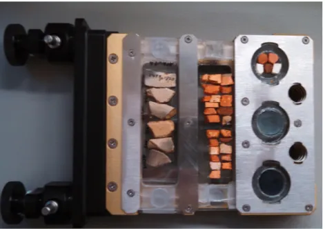
Figure 4.8. Laser ablation sample cartridge. ... 118 !
Figure 4.9. Ablation scar on earthenware. ... 119 !
Figure 5.1. Principal components analysis biplot for production site samples.. ... 128 !
Figure 5.2. Principal components plot of production site samples by
preliminary production zone ... 128 !
Figure 5.3. Bivariate plot of lithium and cesium, coded by continent. ... 130 !
Figure 5.4. Bivariate plot of potassium and tin, showing separation of
Buckley and Liverpool samples. ... 130 !
Figure 5.5. Bivariate plots of rubidium and sodium, above, and silicon and chromium, below, showing separation of Alexandria samples from
those of the broader Tidewater region. ... 131 !
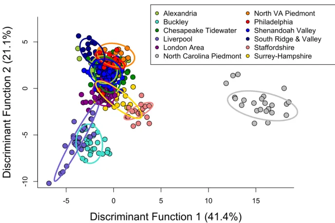
Figure 5.6. Plot of first two discriminant functions, by production zone. ... 134 !
Figure 5.7. Plot of the variables contributing to the first two discriminant
functions. ... 135 !
Figure 5.9. Fragments of conical sugar mold (YTM19, left) and loaf sugar mold (YTM20, right) recovered from the Topham Miller Pottery site
in Philadelphia. ... 138 !
Figure 5.10. Illustration from Diderot’s Encyclopédie, 1762, showing sugar
refining jars and cones in use. ... 138 !
Figure 5.11. Map of the Chesapeake region with location of plantations
sampled in this study. ... 141 !
Figure 5.12. Correspondence analysis plots of assemblages (top), coded
by BLUE MCD, and ware types (bottom).. ... 144 !
Figure 5.13. Discriminant analysis plot showing the projection of the
unknown samples, represented by triangles.. ... 147 !
Figure 5.14. Histogram of discriminant function 1 scores for domestic
samples. ... 148 !
Figure 5.15. Discriminant analysis plot showing the projection of the
unknown samples into modified reference set containing 13 zones.. ... 149 !
Figure 6.1. Summary counts of full ceramic assemblages included in this
study, as representative of Chesapeake as a whole. ... 152 !
Figure 6.2. Identification of coarse earthenware types for the sampled sherds as cataloged, compared to the results of sourcing via elemental
analysis. ... 153 !
Figure 6.3. Assemblage totals for King’s Reach and King’s Reach Quarter,
by material and cataloged coarse earthenware type. ... 155 !
Figure 6.4. Cataloged identification of the sampled sherds from King’s
Reach compared to the elemental sourcing results. ... 156 !
Figure 6.5. Assemblage totals for Ashcomb’s Quarter, by material and
cataloged coarse earthenware type. ... 158 !
Figure 6.6. Cataloged identification of the sampled sherds from
Ashcomb’s Quarter compared to the elemental sourcing results. ... 158 !
Figure 6.7. Assemblage totals for Chapline Place, by material and
cataloged coarse earthenware type. ... 160 !
Figure 6.8. Cataloged identification of the sampled sherds from Chapline
Figure 6.9. Assemblage totals for NAVAIR, by material and cataloged
coarse earthenware type. ... 162 !
Figure 6.10. Cataloged identification of the sampled sherds from
Mattapany manor and NAVAIR compared to the elemental sourcing
results. ... 162 !
Figure 6.11. Assemblage totals for Mount Vernon assemblages, by
material and cataloged coarse earthenware type. ... 164 !
Figure 6.12. Cataloged identification of the sampled sherds from Mount Vernon’s House for Families and South Grove Midden compared to
the elemental sourcing results. ... 165 !
Figure 6.13. Assemblage totals for Fairfield plantation assemblages, by
material and cataloged coarse earthenware type. ... 167 !
Figure 6.14. Cataloged identification of the sampled sherds from Fairfield Quarter and Midden assemblages compared to the elemental sourcing
results. ... 168 !
Figure 6.15. Assemblage totals for Utopia, by material and cataloged
coarse earthenware type.. ... 170 !
Figure 6.16. Cataloged identification of the sampled sherds from Utopia III and Utopia IV assemblages compared to the elemental sourcing
results. ... 171 !
Figure 6.17. Assemblage totals for Monticello assemblages, by material
and cataloged coarse earthenware type. ... 173 !
Figure 6.18. Cataloged identification of the sampled sherds from
Monticello assemblages compared to the elemental sourcing results. ... 175 !
Figure 6.19. Assemblage totals for Poplar Forest assemblages, by material
and cataloged coarse earthenware type. ... 178 !
Figure 6.20. Cataloged identification of the sampled sherds from Poplar
Forest assemblages compared to the elemental sourcing results. ... 179 !
Figure 6.21. Sources for sampled sherds, by phase. ... 181 !
Figure 6.22. Overall ware counts for earthenware assemblages, by phase. ... 182 !
Figure 6.23. Subset of British coarse earthenwares from Chesapeake
!
Figure 6.24. Source predicted by elemental analysis, samples divided by
physiographic province ... 186 !
Figure 7.1. Store account book February 22nd, 1770, recording “Earthen
ware to a Negro” ... 195 !
Figure 7.2 Buckley milk pan from Utopia III. ... 196 !
Figure 7.3. Rim fragment cross-section of London Area redware from
LIST OF ABBREVIATIONS
BLUE MCD Best linear unbiased estimator mean ceramic date
CA Correspondence analysis
DA Discriminant analysis
DAACS The Digital Archaeological Archive of Comparative Slavery
DF Discriminant function
ICP-MS Inductively coupled plasma-mass spectrometry
INAA Instrumental neutron activation analysis
LA-ICP-MS Laser ablation-inductively coupled plasma-mass spectrometry
MCD Mean ceramic date
MD Mahalanobis distance
Nd:YAG Neodymium-doped yttrium aluminum garnet
NIST The National Institutes of Standards and Technology
PC Principal component
PCA Principal component analysis
PIXE Particle induced X-ray emission
RSD Relative standard deviation
SEM-EDS Scanning electron microscope-energy dispersive spectrometry
SRM Standard reference material
STP Shovel test pit
TPQ Terminus post quem XRD X-ray diffraction
CHAPTER 1: INTRODUCTION
While we are accustomed to seeing “Made in the USA,” or “Made in China” on our
products today, this is a fairly recent phenomenon. It was not until 1930 that goods imported to
the US required labeling by country of origin (19 U.S.C. 1304) and there is still no legal
requirement to indicate American products as such. While many current US manufacturers
choose to tout their products as American-made, how were American products marketed and
consumed in the eighteenth century?
In this project I investigate colonial systems of exchange and consumption in the historic
Chesapeake region. The British American colonies were developed to foster mercantilist goals,
focused on the extraction of resources from the colonies and creation of new markets for
manufactured goods. This transatlantic exchange was implemented through credit relationships
backed by the staple crop of tobacco in the Chesapeake colonies of Maryland and Virginia.
Archaeologists in the region have long studied the changing consumption patterns of colonists
over the course of the eighteenth century, as the consumer revolution made imported luxury
items available to a wider public. The majority of domestic items found archaeologically in the
eighteenth century were imported from Europe: refined earthenwares and stonewares, glass,
personal adornment items, and household tools. It has been more challenging to recover proof of
the consumption of locally made products, many of which were ephemeral, made of materials
such as leather, wood, or fiber, and distinctly non-luxury items. However, the division between
economic and social networks, and discrete forms of credit from those of the transatlantic trade. I
have focused on the analysis of coarse earthenwares, omnipresent components of the colonial
American domestic toolkit.
Lead-glazed coarse earthenwares are an ideal artifact type for investigating these
economic networks because unlike many other material goods at the time, which were wholly
imported from Great Britain or elsewhere, coarse earthenwares were also produced locally and
within the broader colonies. In 1736, Virginia Governor William Gooch explained to the British
Board of Trade, “the poorest Familys...who not being able to send to England for such Things
would do without them if they could not get them here ” (quoted in McCartney and Ayres
2004:56-57). Gooch was not writing about luxury or specialty items, but instead describing the
necessity for local production of coarse earthenware pottery. He suggested to his superiors that
domestic manufactures were relegated to the subset of the population who did not carry the
transatlantic credit that would allow them to obtain goods directly from agents in Britain. Were
there truly status-based differences in access to these quotidian goods? While coarse
earthenwares were ubiquitous in the early American home, the routes by which they made their
way into households were variable and have not been adequately explained.
Lead-glazed coarse earthenware is one of the most frequently recovered artifacts on
historic period domestic sites in North America. Often called redware, these wheel-thrown
ceramics served a variety of foodways, hygiene, and industrial functions from the time of the
first European colonization through the nineteenth century. As handmade items the vessels are
inherently distinctive in individual appearance. At the same time, the general technology and
vessel forms were broadly homogeneous across Europe and its colonies, reflecting specific
unadorned and produced in a limited range of forms and surface treatments. Storage vessels such
as crocks and jars, food preparation vessels such as milk pans and bowls, and cooking or baking
vessels, all with a simple lead glaze, formed the bulk of a potter’s trade. Visually, there may be
no clear indicator of whether a vessel was made in England, elsewhere in Europe, or in North
America, as they were rarely marked or signed, and clay differences were masked by the firing
process. The overall result is a seemingly contradictory individuality of single artifacts, and
homogeneity of the class as a whole (Figure 1.1).
Figure 1.1. Red-bodied coarse earthenwares with dark lead glaze. From ceramic production sites in North America (left) and Great Britain (right). Images courtesy the State Museum of Pennsylvania, Pennsylvania Historical and Museum Commission (Philadelphia); Maryland Historical Trust, Jefferson Patterson Park & Museum, Maryland Archaeological Conservation Laboratory
The visual homogeneity of coarse earthenware has meant that archaeologists have largely
overlooked this type of ceramic, in lieu of more visibly distinctive and tightly datable artifacts.
The bulk of utilitarian coarse earthenware tends to lack meaningful categorization, instead being
relegated to catchall categories like “redware,” which could refer to any red-bodied, lead-glazed
vessel made within a 500-year span on one of hundreds of sites in Europe or North America. On
Chesapeake sites in DAACS, the Digital Archaeological Archive of Comparative Slavery, these
generic coarse earthenwares make up nearly 80% of all coarse earthenwares (Bloch 2011:31).
Furthermore, I was troubled by simple dismissals of local production in the eighteenth
century Chesapeake, it being described alternately as sufficient but provincial (e.g., Noël Hume 1969:98-99), or nearly non-existent (e.g., Turnbaugh 1985b:23). These descriptions run counter to the archaeological evidence for numerous production sites across the region, and are
predicated on untested assumptions about the desirability of local products in comparison to
imported goods.
The goal of this project was to break down the monolithic category of visually generic
coarse earthenwares, to quantitatively define the differences among wares from different sources.
This makes it possible to address fundamental questions about the nature of the earthenwares
found in domestic contexts, in turn unlocking the interpretive potential of these multivalent
artifacts. By connecting the production origins of these wares and their use contexts, we can
visualize the overlapping networks of trade and exchange—from local relationships to
trans-Atlantic commerce—that operated in the historic Chesapeake, and identify who was able to
Plantation Archaeology
This project is principally concerned with the consumption of coarse earthenware in
plantation contexts. Over the past 40 years, plantation archaeology has become a large subfield
of historical archaeology. The development of plantation archaeology reflects an engagement
with plantations systems as a whole, and especially with investigation of the lives of the
indentured servants and enslaved Africans and African Americans whose labor made the
plantation system possible. Archaeology on plantations can be separated into two distinct phases.
Early twentieth-century archaeological investigations focused primarily on the main house of the
plantation, often under the guise of historic restoration with little consideration for the greater
plantation landscape and other plantation inhabitants (Heath 2012; Orser 1989; Singleton 1990).
In contrast, more recent plantation archaeology has been concerned with the plantation as a
whole, and investigation of multiple contexts within it, especially explorations of the experience
of slavery (e.g., Ascher and Fairbanks 1971). In hand with the shift in research emphasis has
been a movement away from descriptive studies towards stronger interpretive frameworks and
the incorporation of a wider range of methodologies, sources, and theory (Heath 2012).
In the initial phase of plantation archaeology, the structure of power within the plantation
setting had been taken for granted, and the early studies reinforced understandings of plantation
status and class systems gathered from documentary sources. Research for many years focused
on answering basic questions about how slaves lived (e.g., Crader 1990; Singleton 1985), and the search for African cultural continuities (e.g., Fairbanks 1984; Jones 1985). Several
comprehensive literature reviews have been done on this first phase of plantation archaeology
material remains, and by extension, human behavior. The search for evidence of slave resistance
and owner responses to it was actively launched (e.g., Barile 2004; Orser and Funari 2001; Singleton 2001) Investigations of resistance went hand in hand with the consideration of agency,
specifically regarding the choices enslaved peoples made about their daily lives. The increasing
exploration into notions of power and agency allowed for the development of more complex
understanding of slaves as individuals and as members of groups. In response, archaeologists
began to challenge traditional views of race, class, and the construction of identity, particularly
in terms of gender and ethnicity.
In recent years, there has been a re-integration of the plantation from its constituent parts
and populations. Slaves and slave quarters are no longer considered to the exclusion of other
aspects of the plantation system. “It now seems more appropriate…to study plantations as whole,
complex systems that incorporate agricultural, economic, social and cultural subsystems” (Pogue
1995:101). One framework to achieve this has been to consider plantations as nested households
(Barile 2004), bounded entities in which the labor of all inhabitants and workers contributed to
the overall economic success of the plantation as a whole. At the same point, multiple smaller
entities such as family units or corporate groups also operated as households within a plantation.
While it is challenging to reconstruct meaningful household associations with archaeological
data, household archaeology has become a powerful trend within plantation archaeology (e.g., Battle 2004; Fesler 2004; Franklin 1997). In this study, I focused on the concept of plantation as
nested household, balancing the corporate strategies of the plantation as a whole alongside
smaller household groups divided spatially and by social and economic status.
Taking a regional and diachronic approach, I concentrated on nine plantations occupied
periods. This was the time during which coarse earthenware production and use peaked in the
Chesapeake. The plantations include famous presidential homes, such as Mount Vernon and
Monticello, but also smaller plantations owned by less wealthy and prominent individuals. On
each plantation, when possible, I sampled coarse earthenware assemblages from at least two of
the following types of households: enslaved laborers, free white workers, or the planter’s family.
Most of these assemblages are part of the Digital Archaeological Archive of Comparative
slavery (DAACS; www.daacs.org). DAACS, is “a Web-based initiative designed to foster inter-site, comparative archaeological research on slavery throughout the Chesapeake, the Carolinas,
and the Caribbean” (DAACS 2015a). By aggregating datasets from multiple excavations, and
cataloging them in a consistent way, DAACS permits robust, data-driven research.
In the nested household model of the plantation system, provisioning, a practice that
centrally distributed food and basic items across the plantation, would be expected as the most
efficient way to equip households. However, there is abundant material evidence that enslaved
people independently purchased a variety of consumer goods, including luxury items such as
jewelry and costly ceramics. One of the primary questions of this project was whether coarse
earthenwares were procured individually or provisioned on plantations. Homogeneity in coarse
earthenware assemblages could indicate plantation-wide purchasing and provisioning strategies.
Conversely, differences in the types of coarse earthenwares used in households of varied status
could signal distinct degrees of access to certain products.
Methods
In order to identify the geographic origins of the generic coarse earthenwares found in
relying on the ambiguous visual characteristics, I turned to analytical chemistry, characterizing
these artifacts according to their elemental composition. I first assembled a reference set of
coarse earthenwares from known production sites. I identified 37 historic pottery production
assemblages from across the mid-Atlantic, as well as from England and Wales, and sampled
wasters from each, for a total of 400 samples. Wasters, the ceramic artifacts that did not
successfully survive the production process, are ideal as reference material because they reflect
the recipes and technology of potters. They are thus more similar to successful vessels than raw
clays.
I conducted the elemental analysis for ceramic sourcing using laser ablation-inductively
coupled plasma-mass spectrometry (LA-ICP-MS). This is an analytical technique that provides
quantitative data on a wide range of elements, while being minimally destructive to the samples.
The goal was not to concretely source a vessel used domestically back to a specific production
site. Instead, I focused on defining compositional groups that represented “production zones”
(Monette et al. 2007). There are many more production sites, excavated and unexcavated, than I was able to test. Instead, by using the level of production zone, I follow a broader definition of
source as a community of potters in a geologically distinct area. I then used a variety of
quantitative techniques, especially discriminant analysis (DA), to understand the patterns in
elemental variation among the different production zones, constructing robust groupings
representative of geographic source. From this reference set, I then calculated the probabilities of
group membership for the generically identified sherds (n=184) recovered from 19 plantation
Results
By differentiating these wares according to geological source, it became possible to
isolate previously undefined or under-defined ware types, resolving the broad category of
generic lead-glazed coarse earthenwares into source-specific groups. This is the largest scale
ceramic sourcing project to date in a British American context, both in geographic scope and
sample size. The elemental analysis was very successful, making it possible to identify the
geographic source for over 95% of these coarse earthenwares.
There are clear temporal shifts in the sources of coarse earthenware, and in particular a
steady decrease in the use of imported wares in favor of domestically made products. All
plantation households used at least some locally made wares, and no sharp differences were seen
among the assemblages for households of different status, suggesting that these commonplace
wares were equally available to and utilized by all. General homogeneity of assemblages within
plantations indicates shared access, and potentially plantation-wide strategies such as
provisioning.
The omnipresence of locally made ceramics in these assemblages challenges the
conception that local products were inferior or low-class. Instead, I argue that their omnipresence
is evidence for the pragmatic as well as political strengths of local production, from allowing for
custom orders and local credit, to promoting American self-sufficiency for the nascent
revolution. These factors, cemented in neighborly relationships, sustained local industry in the
Chesapeake even in the face of equivalent imported wares. Local and intercolonial craft
production and trade have been largely overshadowed by the British mercantilist system in the
local products served as meaningful tools for self-sufficiency and engagement within the
community.
Organization
The work is separated into six sections. Chapter 2 presents a historical introduction to the
Chesapeake region, focusing on economic history and the ways in which tobacco production
shaped the character of the region. The agricultural requirements and yearly cycle of the crop
prompted certain patterns in spatial organization and labor. In particular, the dominance of the
staple crop economy and the mercantilist goals of Great Britain are emphasized for their
influence on the nature of trade and exchange in the region. The lack of ready currency promoted
the adoption of credit and indebtedness at all levels of exchange. There were a variety of ways to
obtain goods in the eighteenth century Chesapeake, from direct trade, to retail purchase, to
participation in the global tobacco consignment system. The accessibility of these trade networks
to individuals of distinct social status is discussed, as well as how craft production in the
Chesapeake operated within these nested economic systems. The Chesapeake economy, while
dominated by tobacco agriculture, was not monolithic. Despite the structuring forces of tobacco
production, craft producers, consumers, and merchants developed strategies that were
temporally, geographically, and culturally contingent.
Chapter 3 provides an introduction to coarse earthenware, the main material class under
investigation. In it, I situate the study of historic coarse earthenware within larger disciplinary
questions and debates, from the development of typologies to the analysis of consumption
practices. I begin with a description and background of the ware type and associated research.
lack clear boundaries and subsume meaningful variation. An attribute-level analysis that permits
the independent assessment of characteristics is suggested as the most appropriate way for
classification via macroscopic inspection.
Several models are discussed as a means of explaining the patterns of coarse earthenware
production and distribution in the Chesapeake, based in economic historical frameworks. The
intent is to integrate the study of this ware from production to consumption. I pay special
attention to the concepts of demand and consumption, specifically as they relate to coarse
earthenware in the eighteenth century. Examples are provided to demonstrate the advantages of
local exchange, suggesting that local trade relationships were valuable connections for plantation
residents in the region.
In Chapter 4, I turn to the analytical methods of the study, while framing them within the
broader disciplinary goals for chemical characterization of pottery and other materials. I provide
a background into the relevant geological principles and the concept of source, in order to
explain how elemental analysis can be used to identify the origins of ceramic materials. The
primary geological provinces included in this study are situated as production zones for the
manufacturing of pottery, and I present a description of each pottery production site used to
create the reference set for this study. I then explain the chosen method of elemental analysis,
laser ablation-inductively coupled plasma-mass spectrometry (LA-ICP-MS), with the
step-by-step procedure followed for data collection and processing.
Data analysis is presented in Chapter 5, which is divided into two main sections. The first
section explains the process of data analysis and the methods used to assign the reference set
samples to analytically robust source groups. A total of twelve groups were defined within the
Staffordshire, Surrey-Hampshire Border, and London Area), and seven zones from the
Mid-Atlantic US (Philadelphia, Alexandria, Chesapeake Tidewater [excluding Alexandria], North
Virginia Piedmont, Shenandoah Valley, South Ridge and Valley of Virginia, and North Carolina
Piedmont). Discriminant analysis and Mahalanobis distance posterior probabilities were used to
discriminate and validate membership in these groups.
In the second section, I turn to the procedure used to determine the source of coarse
earthenware sherds sampled from household assemblages on Chesapeake plantations. The
sourcing procedure provided a predicted group assignment for 96% of the 184 sherds sampled.
These results indicate that the production zones identified in the reference set adequately
captured the primary sources of earthenware available to eighteenth-century Chesapeake
residents. Furthermore, an additional source group was uncovered within the domestic site data,
centered within Central Virginia Piedmont assemblages, and it likely represents independent
production in that part of the Chesapeake. This was an unanticipated and tantalizing result, as no
eighteenth-century earthenware kiln sites have been documented here.
In Chapter 6, the results of sourcing are discussed individually for each plantation, with a
brief description of the plantation history and level of archaeological treatment. Overall, the
results show clear temporal trends in the sources of earthenwares available over time and a
dramatic increase in the consumption of locally made wares. Individual plantation strategies such
as provisioning are suggested by the patterning of assemblages within plantations.
In Chapter 7, the broader social meanings of these sourcing patterns are discussed. I pay
special attention to the functions of coarse earthenwares and the ways in which they supported a
variety of household strategies from production to storage. While no sharp status-based
of varying social status had individual kinds of needs for these wares, from low-level storage in
enslaved households to large-scale plantation production of items such as butter at Mount
Vernon. The system of trans-Atlantic credit through the wholesale trade of tobacco is juxtaposed
with the local exchanges of goods along more flexible lines of credit.
While visible markers used to distinguish among coarse earthenware are often
ambiguous, these results demonstrate that it is possible to quantitatively develop meaningful
source groupings through elemental analysis. Future research will focus on reassessing existing
collections based on the results of elemental analysis in order to define and refine our existing
CHAPTER 2: HISTORICAL BACKGROUND
To understand the significance of coarse earthenware in the households of the
Chesapeake, it is necessary to delineate the unique character of this region. Distinguished from
other mainland British colonies by settlement history, economic development, and
demographics, the Chesapeake region created special conditions for the trade of coarse
earthenware. The dominance of tobacco agriculture at the onset of colonization structured every
aspect of life in the region, from where people lived and how they worked, to their social and
economic interactions with others. Over the course of the eighteenth century, as tobacco was
supplanted by other crops in the region, and in the transition from colony to independent nation,
the initial structuring began to break down, creating new opportunities for manufacturing and
new markets for Chesapeake products.
Here, I provide a brief overview of colonial settlement in the Chesapeake region with a
particular focus on its basic unit of organization: the tobacco plantation. I will demonstrate how
the economic system and specifically the reliance upon credit and debt, created novel
intersections of local and global markets. I will emphasize how the articles of these intersections:
tobacco, ceramics, cloth, and numerous other goods, served to maintain colonists’ connections
both to metropole and the local community. Many excellent histories of the Chesapeake have
been written, and I draw heavily on Breen (2001[1985]), Earle (1975), Kulikoff (2000), Morgan
Figure 2.1. Map of the Chesapeake region, showing the early colonial capitals of Jamestown and St. Mary’s City.
Settlement History
The Chesapeake region encompasses the contemporary states of Maryland and Virginia
on the east coast of North America (Figure 2.1). Named for the bay into which it drains, the
region possesses numerous waterways and marine and estuarine resources. The Chesapeake is
temperate and supports a wide variety of plant and animal species such as the persimmon tree
(Diospyros virginiana) and the North American opossum (Didelphis virginiana), two whose names reflect their novelty to Europeans in the New World. Humans have occupied the
Chesapeake for over 10,000 years. In the Early Archaic period (ca. 11,000-8500 BP), small
groups moved seasonally, following game and exploiting wild resources. By the Late Archaic
(Anderson and Smith 2003:7). During the subsequent Woodland period, there was a shift from
nomadic hunting and foraging behavior to plant domestication and settled village life,
intensifying during the late Woodland (post 900 CE). Most groups established villages along the
numerous river networks. In the centuries leading up to European contact three main groups,
identified by language family, occupied the Chesapeake. The Algonquins occupied the Coastal
Plain, the Siouans the Piedmont and further west, and isolated Iroquoians in the southern Coastal
Plain. While differentiated linguistically and through some aspects of social organization and
material culture, the boundaries among these groups were not fixed (Waselkov et al. 2006). At the time of English arrival in the region, most of the Indian population in the Coastal
Plain was politically organized under the rule of Chief Powhatan (Wahunsenacawh), a
Pamunkey chief (Figure 2.2). He governed through local leaders, known as weroances, who occupied settlements along the river networks. Siouan groups such as the Monacans lived in the
Piedmont, with the fall line acting as a buffer zone from the Algonquins. Agriculture at the time
of colonization focused on corn, with beans, gourds, and a variety of grains and legumes, as well
as tobacco.
Though a number of early interactions with American Indians were constructive,
organized around the exchange of goods, hostilities between the Powhatan chiefdom and
European settlers were not uncommon in the first decades of colonization. Over the course of the
seventeenth century several treaties were undertaken between the English and Indian groups in
Virginia and Maryland, some of which resulted in longstanding times of peace (McCartney
2006). During these engagements Indians ceded or sold much of their land and agreed to pay
tribute to British sovereigns. Many died from introduced diseases and warfare, or were enslaved
by Europeans and rival groups. Others left the region, moving further into the interior or joining
with groups in North Carolina.
By the turn of the eighteenth century, it is estimated that less than 2,000 Indians remained
east of the Blue Ridge Mountains (Wood 2006:60). At the end of the century, that number was
down to less than 200, living on small plots of land. Disease and out-migration, coupled with
acculturation and mixed-race relationships, meant that Indians were largely absent or invisible on
the eighteenth century Chesapeake landscape. Nevertheless, as Mouer (1993) argues, Native
American and English interactions in the seventeenth century contributed in great measure to the
success of the colonial venture, and resulted in a creolized population that owed much to the
foodways, subsistence practices, and material culture of the indigenous peoples.
The Chesapeake region was the first successful landing site for English colonization on
North America, after the failed colony of Roanoke Island off the coast of North Carolina in the
1580s. The English authorities were concerned with halting Spanish, French, and Dutch
incursions into the east coast of North America, and thus supported private ventures that would
put an English presence on the landscape. The goal of the Virginia Company of London,
trades with the native peoples, not to establish a new homeland. The first Virginia Company
ships arrived in the Chesapeake in May 1607 and traveled 40 miles up the James River to found
what would be called James Fort, later, Jamestown. Drought, disease, and Indian attacks ravaged
the settlers for the first few years. By the early 1620s, settlement had moved outside of the main
fortification area. The Virginia Company never found the riches and valuable resources that
would make a profitable extractive economy. However, in the 1620s, the production of tobacco
for export began in earnest, and the soils of the Chesapeake proved fruitful for the sweet strain of
this plant introduced to the colony by John Rolfe. After the second Anglo-Powhatan war in 1622,
the Virginia Company lost its charter and Virginia officially became a crown colony. Over the
course of the colonial period, the motivation for agricultural productivity continued unabated,
with repercussions for the settlement history and economic organization.
The colony of Maryland was first settled in 1634. Unlike Virginia, it began under the
proprietorship of a single titled English family, the Calverts. The Calverts were Catholic and
during this time of religious upheaval in England they sought to establish a colony of religious
tolerance. Calvert’s territory extended through the upper Chesapeake, overlapping with territory
claimed by Virginia, and with what would later become Pennsylvania. The first town settled was
St. Mary’s City, near the mouth of the Potomac River. From early in the colonial period, the
colonies of Maryland and Virginia were seen as fundamentally related, described in 1656 as “the
two fruitfull Sisters” (quoted in Russo and Russo 2012:5). They shared the Chesapeake Bay with
its navigable rivers and fertile land. They also shared a climate suited to the production of
tobacco, though they grew different strains, and an economic system based on this staple crop by
Successful production of tobacco required land and labor. For the first hundred years of
settlement, land was readily available. To encourage settlement in Virginia, planters received
land allotments of approximately 50 acres for each family member or servant they brought into
the colonies, under the headright system. In Maryland Calvert, the Lord Baltimore, also provided
land allotments in exchange for the yearly payment of quitrents. The Chesapeake was very slow
to develop towns and cities, because the land requirements for tobacco growing and the need to
easily ship the harvested crop prompted a dispersed settlement pattern. Colonists established
isolated plantations along water networks rather than nucleated settlements.
This pattern persisted well into the eighteenth century (Farmer 1988). As Thomas
Jefferson explained, “our country being much intersected by navigable waters, and trade brought
generally to our doors, instead of our being obliged to go in quest of it, has probably been one of
the causes why we have no towns of any consequence” (Jefferson 2008[1782]:111). The lack of
towns confounded the British government, and was deemed barbaric by contemporaries (Earle
1975:79); yet, even with legislation to force town development, they did not become common in
the Chesapeake until the latter eighteenth century.
Indentured servants largely fulfilled labor needs in the seventeenth century. The colonial
population was unable to reproduce itself due to disease and sex disparity (Horn 1979).
Population pressures drove large numbers of men, women, and children to leave England at this
time in search of work. In the system of indenture, an employer would pay for a servant’s
passage across the Atlantic or buy their indenture from a ship captain. In exchange, an adult
servant would be contracted to work for their employer for a period of generally five to seven
years in order to pay off the debt. While some of the indentured servants had a skilled trade, the
Seventy percent of seventeenth century European immigrants to the Chesapeake arrived as
indentured servants (Russo and Russo 2012:62). As conditions improved in Europe, the supply
of servants decreased and the trans-Atlantic slave trade became an important source of labor in
the form of enslaved African people. While some early Africans were indentured and eventually
received their freedom, by the end of the seventeenth century colonial laws made slavery of
Africans a permanent condition, transferring to their children. This ensured a perpetual,
self-propagating, labor force on the plantations.
By the beginning of the eighteenth century, established landholders had fully taken up the
arable land in the Coastal Plain of Maryland and Virginia. With increasing land pressures, a
period of outmigration began, with settlers heading westward into the Piedmont. The fall line,
marking the boundary between the Coastal Plain and Piedmont physiographic provinces, acted as
a barrier for settlement. Differential erosion of the soft, unconsolidated Coastal Plain soils
compared to the hard bedrock of the Piedmont resulted in waterfalls, disrupting water navigation.
Westward past the falls, rivers such as the James remained navigable by small boats and the
towns of Richmond, Petersburg, and Fredericksburg developed at the fall line as entrepots where
goods moving up and downriver could be moved overland between boats above and below the
falls. Settlement within the Piedmont was dispersed, as in the Coastal Plain, but was less
structured by access to water, as colonial trading paths began to develop at this time. Roads were
more challenging to construct in the hilly, rocky, clay soils of the Piedmont, as opposed to the
flat sandy Coastal Plain, so often these inland roads followed established Indian trails. Rather
than the earlier headright system, settlers obtained land during the eighteenth century primarily
approximately 300 acres, though it was not uncommon for the wealthy and influential to obtain
thousands of acres (Hendricks 2006:10-11).
While some settlers to the Piedmont were fresh arrivals from the homeland, most had
been previously established in the Coastal Plain and moved west in order to secure greater land
for tobacco cultivation. Movement into the Piedmont allowed tenant farmers, who made up a
significant percentage of households in the Coastal Plain, to own their own property. By the mid
eighteenth century numerous new counties had been established in Virginia, large plantations
were common, and the Piedmont had exceeded the Coastal Plain economically. In this boom
time the enslaved population within the Chesapeake rapidly expanded. Though importation of
slaves from the west coast of Africa, often routed through the West Indies, was high during the
first part of the eighteenth century, increasingly it was American-born slaves who drove the
population expansion (Morgan 1998:86). Many of the enslaved people who populated the
eighteenth century Piedmont did not arrive from Africa or the West Indies, but from plantations
in the Coastal Plain.
The backcountry, west of the Piedmont, was demographically, economically, and socially
distinct from the eastern half of the region (Nobles 1989). For most Anglo settlers of Virginia
and Maryland, the Blue Ridge Mountains formed a physical barrier to movement. Though by
1716 the colonial government had surveyed the Great Valley of Virginia, also called the
Shenandoah Valley, the lack of mountain passes, distance from trade networks, and fear of
Indian attacks stunted movement into the backcountry. When settlement of the Valley began
around 1730, it was by settlers moving southward from Pennsylvania rather than westward from
the Piedmont. Following the colonial trading path, groups of migrants began to move into the
continental ethnic and religious minorities, especially Mennonites, Moravians, and Huguenots, as
well as English Quakers. As ethnic minorities, they tended to self-aggregate, establishing
communities of extended families. Towns developed along the trading path, which later became
known as the Great Road or Great Wagon Road. A major episode of town building occurred
during the French and Indian War, as settlers organized together for safety (Hendricks
2006:121). The Virginia government had encouraged the settlement of the Valley as a buffer
from Indian groups.
Rather than establishing large-scale plantations for tobacco, wheat, or other staple crops,
small farmsteads were more common in the Shenandoah and further west in the Appalachians,
with subsistence agriculture and a number of craft specializations. It is estimated that most farms
begun in the early colonial settlement of the Shenandoah Valley consisted of approximately 10
acres of cleared land (Silver 1990:169), due to the difficulties of removing established hardwood
forest. While connected to Pennsylvania and other colonies along the terrestrial trade routes,
these communities tended to be more self sufficient, relying less upon trans-Atlantic
merchandise and credit. In this setting, local craft production such as the manufacture of
earthenware pottery was necessary and commonplace.
The character of the Chesapeake, especially east of the Blue Ridge, was in sharp contrast
to other English colonies on the mainland. In New England, entire families arrived during a brief
period of immigration, and to a large extent recreated the structure of their lives in England in the
new place (Landsman 2003). Towns and hamlets sprang up, with little outmigration once a
family was established. The Puritan beliefs practiced by the immigrants influenced their social
and economic behavior. There was no staple crop in this region; instead, small-scale agriculture
Jersey, and Delaware, also promoted family settlement, the growth of towns, and manufacturing.
For example, William Penn worked to attract craftsmen as colonizers of Pennsylvania. Artisans
continued to arrive from England to Pennsylvania throughout the colonial period and beyond
(Thistlethwaite 1958). While farming was also important in Pennsylvania and the other colonies,
colonists did not practice it to the exclusion of other ventures as in the Chesapeake.
The Plantation
The tobacco trade heavily structured the economy of the colonial Chesapeake. This staple
agriculture product shaped settlement patterns, yearly schedules, and social interactions. Nearly
every worker in the Chesapeake directly or indirectly supported the tobacco trade. In addition to
the numerous slaves, indentured servants, and wage laborers working in tobacco fields,
craftsmen such as blacksmiths and coopers were occupied making the tools and casks necessary
to produce and store the tobacco. Chesapeake planters relied upon trans-Atlantic imports of
many goods such as cloth and housewares that were imported from England where craft
industries still predominated, as they were not being widely produced in Virginia or Maryland.
Coarse earthenware circulated alongside tobacco and other products in this setting, its
production, importation, and distribution structured by the staple crop.
As defined in Chapter 1, I consider a plantation to be a distinct spatial and economic unit.
For British colonists arriving in the American Southeast and West Indies, the plantation was a
newly developed form emerging over the course of the seventeenth century, though as a tool of
colonization it shared ties to the plantation model adopted by the British in Ireland (Horning
2013). The plantation may be conceptualized as an extension of household (Barile 2004), or as a
benefit of the planter. Alongside agricultural labor and other formalized tasks such as dairying,
reproductive labor of slaves also benefited the plantation economically. Spatially, plantations
consisted of a plantation core, which housed the main dwelling and specialized activity areas,
and the agricultural areas, which included fields in various states of cultivation, barns, pasturage,
and other subsidiary activity areas. A large plantation often would be divided into quarters that
operated semi-independently, housing separate groups of workers.
In the Chesapeake region as a whole, most plantations began and were organized around
the requirements of the staple crop, tobacco. Over time, planters shifted towards diversified
production, first in the Coastal Plain and then in Piedmont. In South Carolina, rice and indigo
were the main products, and sugar and coffee in the West Indies. The quick adoption of
plantation agriculture in the Chesapeake was made possible by the presence of maintained Indian
fields and the adoption of Indian agricultural practices. Writing in 1650, Edward Williams
described Virginia thus, “there are immense quantities of Indian fields, cleared already to our
hand, by the Natives, which till we grow over populous may be every way absolutely sufficient”
(quoted in Silver 1990:104). The land was a patchwork of forest, active tobacco fields, and
fallow fields regrowing with first succession plants. Tobacco was planted via the swidden
system. Trees were girdled or chopped down, though often leaving tree trunks in place. Workers
tended tobacco plants using hoes and manual labor rather than requiring the plows and draft
animals more common for grain agriculture. A field remained fertile for several years of planting
before necessitating a long fallow period. In this system, it was expected that each laborer could
care for several acres of tobacco. While plantations could be large, the land actively under
cultivation was a small proportion, except for the wealthiest plantations with considerable
Tobacco production was an intensive yearlong cycle from seed to sale. In December,
tobacco seeds would be planted in a seedbed, and protected from frost. In late spring, workers
transplanted seedlings to the fields. As the tobacco grew over the summer months, it required
constant care. Field hands worked in gangs, using hoes and hand tools to plant, weed, and care
for the growing tobacco. The top of the plant was removed to ensure that growing energy
remained devoted to the leaves. In early fall, before frost, the plants were cut, and hung to cure in
the drying barns. When deemed sufficiently dry, workers packed the tobacco into hogsheads as
tightly as possible in a process known as “prizing”. This resulted in hogsheads weighing up to
1000 pounds. It was now winter, and the cycle would begin anew. English and Scottish ships
began to arrive in late fall and would collect tobacco from individual plantations, and later
tobacco warehouses at ports. Over the course of weeks to months, a ship would fill their hold
with tobacco hogsheads before returning to Europe to sell the crop.
Beginning in the early eighteenth century, in response to falling tobacco prices and
declining soil productivity, Chesapeake planters in the Coastal Plain began to diversify, growing
wheat and other grains. Wheat was shipped as grain and milled flour not only to Europe, but also
to the colonies of the Northeast (Shepherd and Williamson 1972). This shift of staple crops had
repercussions across the plantation landscape, changing the spatial organization and the yearly
cycle (Neiman 2008). Grains required plowed fields, so unlike the swidden system with tree
trunks left in place, workers prepared cleared fields. Draft animals were needed for the plows
and carts, and for the manure they produced. In comparison to tobacco, grain production was less
labor intensive, and could be worked during downtime in the tobacco cycle. The diversification
crafts and individualized tasks. On some large plantations, dairying, beer brewing, and other
activities of household production required significant outlays of labor and materials.
The wealthy colonists who first established plantations in the Chesapeake were investors
attempting to diversify their prospects. The majority of land and resources in the eighteenth
century Chesapeake was under the control of relatively few planters. These elite planter families
tended to concentrate their wealth through intermarriage and cousin marriage, leading to massive
plantation complexes encompassing thousands of acres. Two thirds of planters in the Coastal
Plain possessed less than 200 acres (Morgan 1998:43), and these poor to middling planters often
began their life in North America as indentured servants or artisans. They operated on a much
smaller scale than their wealthier neighbors, with a perhaps few slaves or servants and producing
small yearly tobacco crops. Wealth disparities became more pronounced over the course of the
seventeenth and eighteenth centuries. While in the early years of colonization, even rich planters
tended to live in modest houses of a few rooms without grand furniture or housewares (Sweeney
1994), this soon changed. Homes of the wealthy became larger, more elaborate, and more
permanent—made of brick rather than earthfast and frame architecture.
In addition to the planter’s family, plantation residents typically included a mixture of
free and bonded workers. In the seventeenth century these were most commonly indentured
servants. As economic conditions improved in Europe, planters began to rely more heavily on
imported slaves arriving from Africa or the West Indies, transitioning fully to enslaved African
and African American labor in the early eighteenth century. Enslaved field hands in the
eighteenth century were commonly segregated from the planter’s family in dispersed
communities across the plantation. This distribution kept them close to the fields they worked in
as cooks and maids, or as craft specialists, would reside in the plantation core to better access
their work sites. Spinning, weaving, and basic carpentry were common trades assigned to slaves;
Monticello was one of the few plantations that had more specialized industries such as nail
making, tin-smithing, and furniture production (Kelso 1997). Most Chesapeake planters
provisioned their slaves with weekly food rations and minimal clothing and household items. To
supplement their diet and household economy, slaves planted household gardens, fished and
hunted, raised chickens, produced crafts such as baskets and brooms, and worked additional jobs
for wages.
An overseer, usually a free white employee of the planter, would live in some proximity
to a community or communities of slaves, in order to ensure their labor and submission.
Overseers were the most common wage laborers on plantations, though some plantations had
specialized positions for free men as builders, masons, millers, or other plantation tasks. In some
cases, tenant farmers or poor neighbors would also work on large plantations as a means of
paying off debt or obtaining wages.
The plantation settlement system of the Chesapeake was distinct from that of other
British colonial regions. Plantations were standard in the Carolinas as well, though different in
scale and production. Planting rice required a larger capital investment and greater landscape
transformations. Rather than on a tobacco plantation, where there was no real economy of scale
in the number of laborers, rice plantations required large numbers of enslaved workers in order to
operate (Morgan 1998). Large plantations were in the norm in the Carolina lowcountry and
profits were generally higher than in the Chesapeake, giving even less incentive to diversify.