TOPOGRAPHIC DOCUMENTATION FOR THE DESIGN OF WATER NETWORK AND WASTEWATER NETWORK IN LOCALITY PERISOR, DOLJ COUNTY
BUZATU C., CĂLINA A., CROITORU A., MILUŢ M.
1Faculty of Agronomy, University of Craiova
ABSTRACT
The particular aim of this paper is the surveying surface of Constantin Brancusi street from the village Perişor, Dolj County, to draw up the of documentation for modernization of water network and wastewater network in commune Perişor. The beneficiary of study is Perisor Townhall which has provided all the necessary elements and details for measurements processing. The working methods chosen to achieve documentation consist of measurements with GPS devices because of the advantages offered by this technology but also because in the village Perisor there are few points of triangulation known from state geodetic network. The plans of location and delimitation of road sections from commune Perisor are made on the A3 format page at a scale of 1: 2000 which allows a more detailed representation of the conducted topographic survey.
INTRODUCTION
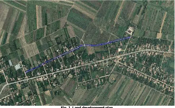
The hereby work refers to the Perisor commune, Dolj county. Perisor is located about 40 km away from Craiova and includes 2 settlements: the Perisor village (commune capital) and Maracinele, located 4.2 km to the N-NE of Perisor. The commune is located to the South.Road connection to Craiova takes place on E79, at the exit from the Jiului Lowlands.
Fig. 1. Land development plan
PURPOSE AND USED METHODS
The hereby work specifically aims at the topographical elevation of the area of the Constantin Brancusi street of Perisor, Dolj county, with a view to drawing up all location and delimitation plans to The hereby work specifically aims at the topographical elevation of the area of the
and delimitation plans to enhance the water and waste water infrastructure of Perisor, the beneficiary of the study. The work methods selected for the performance of topographical elevation consist of GPS measurements, due to the advantages provided by this technology, as well as the fact that few known triangulation points in the public geodesy network are available in the concerned area. GPS determinations may be done both when a GPS network exists and when such a network is unavailable.
The projection system used for measurement processing will be the national reference system Stereographic 1970 and the Marea Neagra 1975 reference. Certain measurements will be performed in the WGS '84 projection system, but, for processing purposes, they will be turned into a Stereographic 1970 system, using the programme with transformation parameters TransDat Ro 4.01, provided free of charge by ANCPI (the Agency for Land Registration and Real Estate Publicity).
A GPS device and a total TOPCON GTS 212 station were used for the performance of topographical elevation.
A Leica 900 GPS receiver with the following features was used for points determined through the static method:
Using the L1, L2 frequencies
256 MB internal memory and battery duration up to 5 hours of measurements.
Possibility to read both GPS and GLONASS satellites
It can be used for static and cinematic measurements with a fixed base Number of channels: 26 L1 + 26 L2 GPS/GLONASS
Base measuring accuracy: 3mm + 0.5ppm for L1+L2 Accuracy in RTK: 10mm + 1ppm for L1+L2
The following device was used for commands sent to the receiver during measurements:
- RX900 controller. It has a 256 MB internal memory and is based on the Windows Mobile CE 5.0 software, and the LEICA Geo Office Software shall be used for performing measurements. Touch Screen interface and battery duration up to 20 hours of measurements. Wireless connection between the RX900 controller and the Leica 900 GPS receiver.
Documentation and elaboration of the topographical elevation design
Representatives of the Perisor Municipality performed land recognition as follows: The municipality provided a map of Perisor, where, together with the designer and the topographer, the streets and the limits of property were identified, where detail and levelling topographical elevation are to be performed.
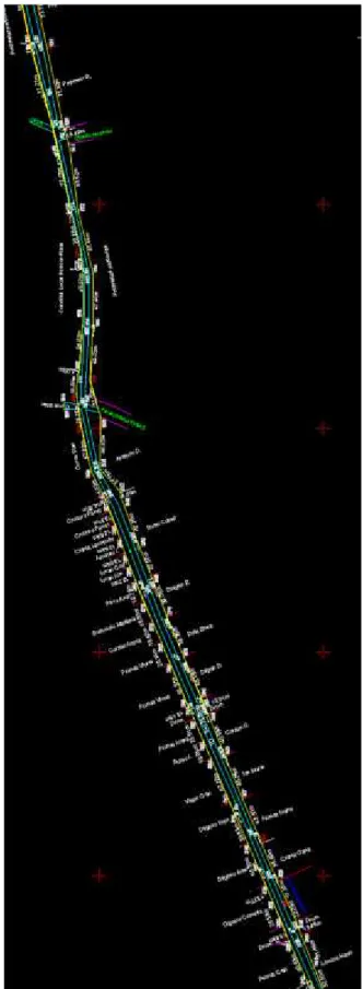
New station points 0, 1, 20, 21 were determined by means of the above mentioned GPS Leica 900 device and the records of data in permanent ROMPOS stations - BAIS (Bailesti) and CRAI (Craiova) (Fig. 2.)
Points 0, 1, 20, 21 were shown on the site with a grounded wooden pillar, marked in red dye.
The Leica receiver was mounted on the metal tripod; this was optically centered and focused on the pillar representing point 0. A metal ruler was used to measure the height of the device to be used for determining the quota of point 0, after assembly. The height of the device was input to the controller software, under the specific heading.
After checking the number of available satellites in the area, they were found to exceed the maximum number of four. The approximate accuracy displayed by the specialised software was then followed, and the receiver was started in the "Start base" recording mode. This command allows the GPS receiver to record data from satellites with a view to determining the point through the static method.
Fig. 2. The sketch of GPS-determined points
The total TOPCON GTS 212 station was used for the following phase. Points 2, 3, 5, 7,8, 9,10,11, 12, 13 14, 15, 16, 18, 19, 22 were determined through a road planning supported on the ends (0, 1-20, 21), of which the points required to draw up the location and delimitation plan were erased.
The actual erasure of points was performed next, as they were marked on the on-site sketch. Codes were used for certain points, with a view to facilitating data processing in the office.
Topographical measurements were based on a levelling, considering the designer's requirements and mentions. The following details were measured:
Detailed surface and levelling topographical elevation were performed for the lands established to be used as a location for the Constantin Brancusi street.
Since GPS devices were used, detail points calculations were performed by means of specialised data processing software.
- For measurements performed with the previously described Leica 900 devices, data processing was made with the Leica GeoOffice licensed software, through post-processing.
As of December 15, 2009, TransDat Ro is implemented in all counties and Bucharest with a view to performing, checking and accepting land registration, geodesy, photogrammetry and remote detection works.
The TransDat Ro version 4.04 software is used for this operation.
Calculation of road planning supported on the ends, and erasure points
Points 2, 3, 5, 7,8, 9,10,11, 12, 13 14, 15, 16, 18, 19, 22 were determined through a road planning supported on the ends (0, 1-20, 21), of which the points required to draw up the location and delimitation plan were erased.
The erasure method was used to calculate the coordinates of detail points, which was applied in all station points of the road planning supported on the ends, calculated as above.
Location and delimitation plans were drawn up through computer-based processing, using the AUTOCAD 2009 software, the TOPO-LT software and AUTOCAD RASTER DESIGN 2009.
The location plan of the street and the relevant details in Perisor was drawn up in a standardized digital format (dwg file), as well as an analog format (paper-based), including:
- The general map of the measured street
Representing a generalised map of the street where measurements were performed and drawn up on an A3 format, scale 1:2000.
- Detail plans, by sections
The detail location and delimitation plans for the road sections of Perisor are drawn up on an A3 page format, scale 1:2000, allowing for a more detailed representation of the performed topographical elevation (Fig. 3).
CONCLUSIONS AND RECOMMENDATIONS
1. In conclusion, the purpose of performing the topographical elevation of the Constantin Brancusi street in Perisor, Dolj county, with a view to drawing up the location and delimitation plan for infrastructure enhancement, was achieved.
2. Modern generation devices were used, including a GPS Leica 900 receiver and a total TOPCON GTS 212 station.
3. Works were performed according to the technical requirements established in the guidelines, rules and regulations in force. The following were observed when drawing up the work:
- the provisions in the performance approval
- the location, materialization and flagging of new points
- the methods to perform on-site and office operations, to achieve graphical and textual data,as well as their correctness and accuracy.
9. The project had the following annexes: Sketch for new station points, GPS measurement reports for the static method, On-site book, Coordinate inventory, Calculation of road planning supported on the ends, Calculation of coordinates of detail points - Erasure, sheet with the plan performed for the project
BIBLIOGRAPHY
1. xxx Order of the General Director of ANCPI no. 700/2014 on the approval of the Regulation on the content and elaboration of land registration documentation for land book registration purposes;
2. Călina A., Călina Jenica, Croitoru A., Study on Building of Planimetric Network Stakeout for a Commercial Space Using Combined Technology GPS-Total Station, Conference Agriculture for Life, Life for Agriculture, Vol. 6, USAMV Bucharest, pp127-135, 2015.
3. Călina A. et al., Topografie generală şi inginerească, Sitech, Craiova, ISBN 973-657-945-X, 2010;
4. Călina Jenica, Călina A., Miluț M., Băbucă N. - Surveying data processing for extension, land registration and construction improvement, Annals of the University of Craiova - Agriculture, Montanology, Cadastre Series, pp. 47- 57, Vol. XLIV/2 2014;
6. Miluț M., Călina Jenica, Călina A., Croitoru Alin, 2014, Elaborating documentations for changing the category of use to construct a field of photovoltaic panels, Annals of the University of Craiova - Agriculture, Montanology, Cadastre Series, pp. 127-131, Vol. XLIV/2 2014;
www.ancpi.ro ; www.rompos.ro ;