CONNECTING NEVADA PHASE II
Technical Memorandum #4:
Statewide Travel Demand Model Development Plan
Table of Contents
1 Introduction ... 1
1.1 Model Geography ... 1
1.2 Traffic Analysis Zones ... 3
1.3 Passenger Trip Models ... 3
1.4 Non-Resident Travel ... 4
1.5 Special Trip Generators ... 4
1.6 Passenger Trip Distribution ... 5
1.7 Passenger Mode Split... 5
2 Freight Model Architecture ... 6
2.1 Model Purpose ... 6
2.2 Overview of Freight Model Practices ... 6
2.3 Commercial Vehicle Model Approach ... 6
3 Traffic Assignment and Model Validation ... 8
3.1 Model Validation Parameters ... 10
List of Tables
Table 1 Network Link Attributes ... 9 Table 2 Road Classification, Lane Daily Capacity and Area Type ... 10
List of Figures
1
INTRODUCTION
The purpose of the Nevada Statewide Travel Demand Model (NVTDM) development effort is to provide a fully operational three step statewide travel demand model to define deficiencies and needs as part of the
Connecting Nevada effort. The study team will use the NVTDM primarily to test new major corridors and identify deficiencies on state highways and interstate facilities outside the coverage area of the current urban transportation models.
The NVTDM will include short-, near-, and long-ranges forecasts (5-year, 20-year, and +50 year). The travel markets used in the NVTDM will include:
short distance person travel – trips less than 50 miles in length;
long distance person travel – trips greater than or equal to 50 miles in length; short distance truck trips within Nevada generally in urban areas and,
long distance truck trips representing regional freight flows.
The NVTDM will be maintained, updated, and operated by the Nevada Department of Transportation (NDOT). Public transportation will not be modeled.
1.1
MODEL GEOGRAPHY
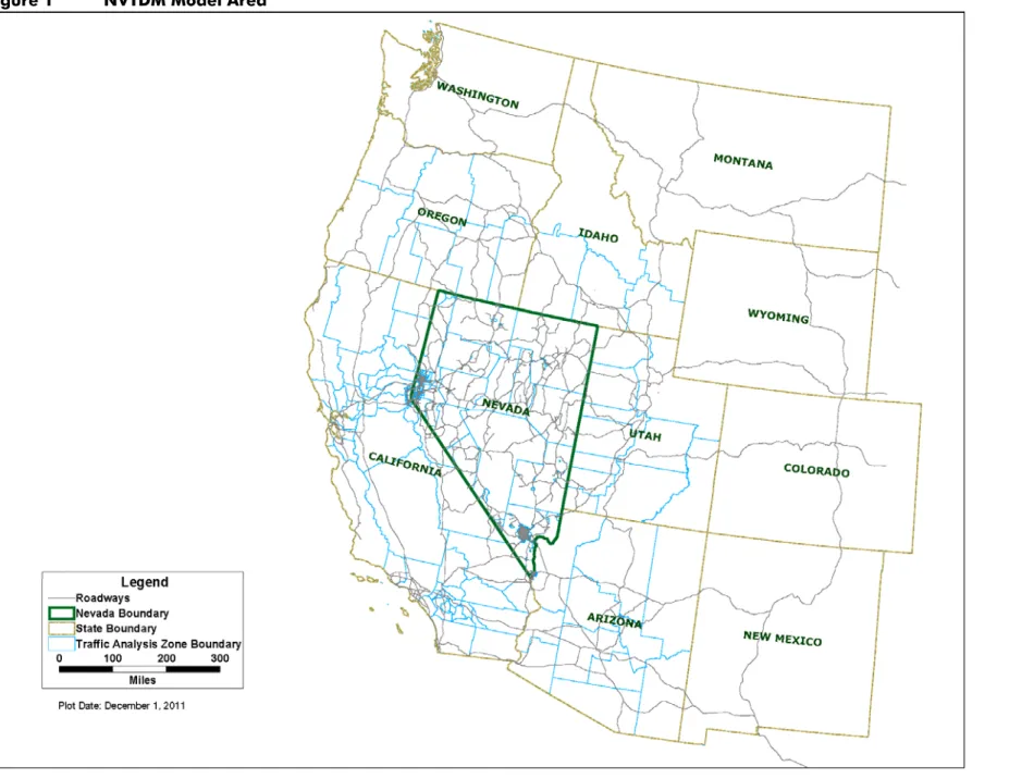
The NVTDM model area includes Nevada and 10 western states. This larger model area, shown in Figure 1, provides a context for estimating regional travel including truck traffic and long distance trips between urban areas. The traffic analysis zone (TAZ) geography is more detailed within Nevada. Counties are the primary TAZ geography in the surrounding states. The urban areas of Southern California and Northern California are exceptions. The TAZ in these areas are based on regional analysis zones established by local planning authorities. The NVTDM will link together travel demand models from the Southern Regional Transportation Commission (RTC), the Washoe RTC, the Carson Area Metropolitan Planning Organization (CAMPO), and the Tahoe MPO. The study team will develop the road network for urbanized areas outside of MPO or RTC areas using roads in Nevada’s Highway Performance Management System (HPMS) database. Other minor facilities may be included as necessary to ensure system continuity.
In addition, the NVTDM network will extend beyond the state boundary to cover 11 western United States shown in Figure 1. This extended network and traffic analysis zone geography is aimed at capturing long distance person and truck travel at a larger scale to understand total flows. This broader model area also allows the model to capture the important long distance visitor market to Nevada.
1.2
TRAFFIC ANALYSIS ZONES
The MPO travel demand model traffic analysis zone (TAZ) geography will be used for urban areas. Outside of the MPO areas, the study team will use census statistical area boundaries, county boundaries, roads, rivers, and other physical features to establish TAZ geography. Larger TAZs will be used for unpopulated areas. Smaller geography will be used to ensure traffic from small cities and towns is loading the network accurately.
1.3
PASSENGER TRIP MODELS
The NVTDM will estimate person trips for seven trip purposes. This will include six short distance trip purposes and one long distance trip purpose. Vehicle occupancy rates will be used to convert these trips into passenger vehicle trips:
home-based work (HBW); home-based university (HBU); home-based school (HBS) home-based other (HBO); non-home-based (NHB); non-resident visitor trips; and, long distance trips.
These models will be adapted primarily from the Southern RTC travel demand model. The NVTDM will utilize recent advances in long distance travel modeling using nationally available data (Moeckel & Donnelly, 2010) to generate long distance person trips.
1.3.1
HOUSEHOLD TRIP MODEL
The NVTDM will forecast 24-hour travel demand in person trips, using a household-based cross classification trip generation model based on the Southern RTC trip production models. Trip generation variables will include household size and household income. Sub-models that will be adapted from the Southern RTC model include:
household size disaggregation sub-model;
households by income group disaggregation sub-model; and, joint distributions of households by socioeconomic strata sub-model. cross-classification trip generation models by trip purpose
As part of the model calibration process, trip rates will be verified using the 2008 National Household Travel Survey (NHTS). Census 2010 and American Community Survey estimates will be used to prepare the base year NVTDM socioeconomic inputs. For each MPO areas, the 2010 NVTDM inputs will be compared to base year models.
1.3.2
HOUSEHOLD TRIP ATTRACTION
The NVTDM passenger trip attraction model specifications will be adapted from the Southern RTC travel demand model. Employment will be classified by TAZ as follows:
retail and wholesale trade; office employment;
casino employment; and, hotel employment.
For urban areas, employment will be developed by TAZ from the MPO travel demand models. For rural areas, the study team will use a commercially available sales leads database. Employment estimates derived from the sales leads database will be compared with Bureau of Labor Statistics Quarterly Census of Employment and Wage (QCEW) data as well as county and ZIP Code employment totals identified in the Census Bureau’s 2009 County Business Patterns data.
In addition to employment, both university and school enrollment will be adapted from the MPO travel demand models and other sources for use in the home-based school and home-based university trip attraction models.
1.4
NON-RESIDENT TRAVEL
Non-resident visitors generate significant travel demand on the state highway system. Each of the Nevada MPO travel demand models account differently for visitors. For example, the Southern RTC visitor model simulates travel demand for both multi-day and single-day visitors. The Lake Tahoe travel demand model has separate summer and winter visitor models.
The NVTDM will rely on the MPO models to develop a non-resident travel model. The MPO models use hotel rooms and occupancy rates to estimate visitor trip generation. Existing visitor trip attraction models primarily use employment:
resort casino;
office employment; and, retail employment.
For urban areas, employment will be developed by TAZ from the MPO travel demand models. For rural areas, the study team will use a commercially available sales leads database. Employment estimates derived from the sales leads database will be compared with county and ZIP Code employment totals identified in the Census Bureau’s 2009 County Business Patterns data.
The NVTDM will account for the role of the Las Vegas Convention Center and the Lawler Event Center in attracting non-resident travel by including them as special generators.
1.4.1
LONG DISTANCE MODEL
The NVTDM project team will prepare a long distance trip model to capture trips made both by non-resident visitors and residents that are greater than 50 miles. The 2001 Federal Highway Administration National
Household Travel Survey is an inventory of daily and long distance travel. This data together with other publically available sources will be used estimate long distance travel to Nevada from surrounding states. These datasets will also be used to estimate long distance trip production and attraction rates for Nevada residents.
1.5
SPECIAL TRIP GENERATORS
Special generators are used within travel demand models to reflect the unique trip attraction characteristics of certain land uses. Examples of special generators that will initially be used in the NVTDM are noted below. Additional unique generators may be considered during data development and validation.
Major Airports Convention Centers
Military Installations Universities
1.6
PASSENGER TRIP DISTRIBUTION
The NVTDM will use a standard gravity expression for passenger trip distribution. The gravity expression will use either highway free flow time or a composite impedance of distance and free flow travel time. Friction factors will be adapted from the Arizona urban models and other states’ modeling efforts.
American Community Survey 2010 journey-to-work data, 2008 NHTS data, and distribution data from the MPO and RTC models will be used to obtain trip length distributions and travel time for gravity model calibration.
No data collection is required for this step.
1.7
PASSENGER MODE SPLIT
Person trips will be converted to vehicle trips using automobile occupancy rates by trip purpose. These automobile occupancy rates will be adapted from the MPO and RTC models and other statewide models as necessary. The focus of the NVTDM is on state highways largely outside the state’s urban areas, where public transit does not represent a substantial number of trips. In addition, the level of data collection and
development time needed to implement a public transit mode split component is beyond the resources of this project.
2
FREIGHT MODEL ARCHITECTURE
2.1
MODEL PURPOSE
The purpose of the statewide freight model is to understand the impact that freight activity has on Nevada’s highways to help identify the roadway infrastructure improvements needed to accommodate anticipated growth in goods movement.
2.2
OVERVIEW OF FREIGHT MODEL PRACTICES
There a number of methods for estimating statewide travel demand models. The Federal Highway
Administration (FHWA) Quick Response Freight Manual II (Beagan, Fischer, & Kuppam, 2007) and NCHRP Report 606: Forecasting Statewide Freight Toolkit (Cambridge Systematics, Cohen, Horowitz, & Pendyala, 2008) provide a summary of the literature as well as case studies in statewide freight forecasting. Statewide freight forecasting methods range from simple to complex and include:
trend-based growth factor methods;
economic projection-based growth factor methods; “four-step” freight forecasting;
commodity models; and, hybrid model approaches.
2.3
COMMERCIAL VEHICLE MODEL APPROACH
The NVTDM study team will take advantage of existing goods movement data to develop a hybrid approach that blends truck forecasts from the FHWA Freight Analysis Framework (FAF) version 3 with the commercial vehicle model from the FHWA QRFMII. The FAF version 3 (FAF3) is a database of nationwide goods movement. Based on data from the 2007 Commodity Flow Survey and additional sources, FAF3 provides estimates for tonnage and value by commodity type, mode, origin, and destination for 2007 and 2040.
FHWA has also prepared a truck traffic assignment using FAF3 freight flows for 2007 and 2040. The FAF3 truck assignments and commodity flow data will be used to prepare a truck trip table for both intrastate and interstate truck activity. This hybrid approach will disaggregate the FAF3 commodity flow data to TAZs based on zonal employment. Using payload factors, the project team will convert commodity flows to trucks and prepare an initial 2010 truck trip table. This initial truck trip table will be assigned to the highway network and compared to the FAF3 truck trip assignment.
A hybrid approach to modeling commercial vehicles is needed because the FAF3 data does not capture local truck trips or service deliveries. A second truck trip table will be estimated using QRFMII truck trip rates (Table 4.1) to capture these short distance trips. These rates will be applied to zonal employment to estimate trip generation for local single unit and multiple unit truck activity. A gravity model will be used to distribute truck trips. The resulting trip table will be compared to FAF3 trip table. The two trip tables may be combined and adjusted to match 2010 truck counts on the regional highway system.
2.3.1
SPECIAL TRUCK TRIP GENERATORS
Special freight generators may be used within the freight model to reflect unique commercial vehicle trip making characteristics. Examples of special freight generators that may be used include:
mines;
intermodal terminals; cargo airports; and, distribution centers.
2.3.2
TRUCK FORECASTS
One of the purposes of this model is help assess the need for the proposed I-11along current U.S. 93 and U.S. 95 in Arizona and Nevada and north to Oregon and Washington. It is anticipated that congestion on Interstate 5 in California may divert regional truck activity to a new interstate east of the Sierra Nevada. In addition, the Port of Los Angeles and the Port of Long Beach are reaching capacity. The development of new deep water ports in Mexico would provide relief to these West Coast ports; I-11 could provide a link between new Mexican ports and markets in the Pacific Northwest. Commodity flows in the FAF3 database can be manipulated to simulate the shift of activity to a new port and update the NVTDM truck trip table to model these scenarios.
3
TRAFFIC ASSIGNMENT AND MODEL VALIDATION
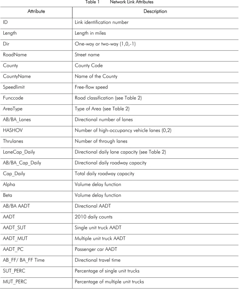
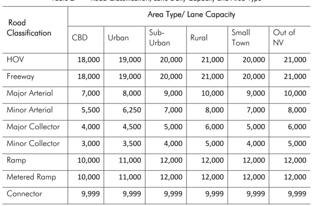
The traffic assignment step will combine trips from the passenger vehicle and commercial vehicle modules for assignment to the NVTDM roadway network. The model will use the TransCAD Multi-Modal Multi-Class Assignment (MMA) user equilibrium traffic assignment routine. The model will be link-based and capacity constrained. Table 1 shows the network link attributes that will be used in the NVTDM road network. Table 2 shows the road classification and lane capacities that will be adopted for all facilities in the NVTDM.
Table 1 Network Link Attributes
Attribute Description
ID Link identification number
Length Length in miles
Dir One-way or two-way (1,0,-1)
RoadName Street name
County County Code
CountyName Name of the County
Speedlimit Free-flow speed
Funccode Road classification (see Table 2)
AreaType Type of Area (see Table 2)
AB/BA_Lanes Directional number of lanes
HASHOV Number of high-occupancy vehicle lanes (0,2)
Thrulanes Number of through lanes
LaneCap_Daily Directional daily lane capacity (see Table 2) AB/BA_Cap_Daily Directional daily roadway capacity
Cap_Daily Total daily roadway capacity
Alpha Volume delay function
Beta Volume delay function
AB/BA AADT Directional AADT
AADT 2010 daily counts
AADT_SUT Single unit truck AADT
AADT_MUT Multiple unit truck AADT
AADT_PC Passenger car AADT
AB_FF/ BA_FF Time Directional travel time
SUT_PERC Percentage of single unit trucks MUT_PERC Percentage of multiple unit trucks
Table 2 Road Classification, Lane Daily Capacity and Area Type Road
Classification
Area Type/ Lane Capacity
CBD Urban Sub- Urban Rural Small Town Out of NV HOV 18,000 19,000 20,000 21,000 20,000 21,000 Freeway 18,000 19,000 20,000 21,000 20,000 21,000 Major Arterial 7,000 8,000 9,000 10,000 9,000 10,000 Minor Arterial 5,500 6,250 7,000 8,000 7,000 8,000 Major Collector 4,000 4,500 5,000 6,000 5,000 6,000 Minor Collector 3,000 3,500 4,000 5,000 4,000 5,000 Ramp 10,000 11,000 12,000 12,000 12,000 12,000 Metered Ramp 10,000 11,000 12,000 12,000 12,000 12,000 Connector 9,999 9,999 9,999 9,999 9,999 9,999
Notes: Lookup table adapted from Second Generation Arizona Statewide Model
3.1
MODEL VALIDATION PARAMETERS
While no guidelines are available for validation of statewide models, validation procedures used in urban travel demand models will be used for the NVTDM. The NVTDM will be validated to 2010 passenger vehicle counts and truck counts using validation criteria including:
VMT by functional classification absolute deviation; link root mean-square error (RMSE) by facility type; cut line traffic count absolute deviation;
coefficient of determination (r2) between volume forecasts and counts; trip length frequency distribution; and,
3.2
MODEL VALIDATION TECHNIQUES
Validation is the iterative adjustment of model parameters so that model predicted traffic volumes reasonably match base year traffic counts. Validation of the freight model will include the following steps:
adjustment of external internal trip generation rates; adjustment of roadway speeds and capacities; and, adjustment of TAZ model centroid connector locations.
GLOSSARY OF TECHNICAL TERMS
Absolute Deviation – In statistics, the absolute deviation of an element of a data set is the absolute difference between that element and a given point. In the case of travel demand modeling, this is the absolute difference between the model estimated volume and the observed traffic count.
Coefficient of Determination (r2) – This is a measure of the strength and direction of the linear relationship between model predicted traffic volumes and actual traffic counts. This is a measure of how well the regression line represents the relationship between estimated model volumes and observed traffic counts.
Cut Line – A cut line is an imaginary line drawn across major roadway facilities in a corridor. A total cut-line model estimated traffic volume is obtained by adding up all the volumes on the individual roadways that cross the cut line. Similarly, all observed traffic counts are added up on the individual roadways that cross the cut line. A comparison of estimated cut line volumes and observed traffic counts provides an assessment of model performance.
Friction Factors – Variables that quantify the impedance or measure of separation between two traffic analysis zones. Friction factors are inversely related to the spatial separation of zones, decreasing as impedance increases.
Gravity Expression – Trip distribution method originally generated from an analogy with Isaac Newton’s gravitational law. This analogy posits that the interaction between two locations declines with increasing impedance (distance, time, and cost) between them, but is positively associated with the amount of activity at each location.
Impedance – Various measures of cost (distance, time, transit fare, parking cost, etc.) used in the gravity expression to estimate the interaction between two locations.
Percent Error – Shows the relative error between an observed traffic count and a model estimated traffic volume as a percentage.
Root Mean Square Error (RMSE) – A measure of the differences between traffic volumes predicted by a model and the observed traffic counts.
Trip Length Frequency Distribution – This is a curve that shows the distribution of model estimated trip lengths by trip purpose.
WORKS CITED
Beagan, D., Fischer, M., & Kuppam, A. (2007). Quick Response Freight Manual II. Washington, D.C.: Federal Highway Administration.
Cambridge Systematics, I., Cohen, H., Horowitz, A. J., & Pendyala, R. (2008). NCHRP Report 606: Forecasting Statewide Freight Toolkit. Washington D.C.: Transportation Research Board.
Center for Urban Transportation Studies University of Wisconson-Milwaukee. (1999). Guidebook on Statewide Travel Forecasting. Washington, D.C.: Federal Highway Administration.
Erhardt, G., Freedman, J., Stryker, A., Fujioka, H., & Anderson, R. (2007). Ohio Long-Distance Travel Model. Transportation Research Record; Journal of the Transportation Research Board No. 2003 , 130-138.
Giaimo, G. T., & Schiffer, R. (2005). Transportation Research Circular E-C075: Statewide Travel Demand Modeling A Peer Exchange. Washington, D.C.: Transportation Research Board.
Hancock, K. L. (2006). Freight Demand Modeling: Tools for Public-Sector Decision Making. Transportation Research Board Conference Proceedings 40. Washington, D.C.: Transportation Research Board.
Horowitz, A. J. (2006). NCHRP Synthesis 358: Statewide Travel Forecasting Models A Synthesis of Highway Practice. Washington, D.C.: Transportation Research Board.
Horowitz, A. J. (2008). White Paper: Statewide Travel Demand Forecasting. Washington, D.C.: Transportation Research Board.
Moeckel, R., & Donnelly, R. (2010). Nationwide Estimate of Long-Distance Travel (NELDT) Generation of External Trips for Local Travel Models. Third International Conference on Innovations in Travel Modeling (ITM). Tempe, Arizona: Transportation Research Board.