ISSN: 2334-2986 (Print), 2334-2994 (Online) Copyright © The Author(s). All Rights Reserved. Published by American Research Institute for Policy Development DOI: 10.15640/jea.v4n2a11 URL: https://doi.org/10.15640/jea.v4n2a11
Sustainability Evaluation for Low-Cost Housing Projects
With special reference to Khartoum State Fund for Housing and Development
projects
Z. E. Awad1 and Z. O. Gaafer2
Abstract
Low- cost housing projects in developing countries can be considered a burden more than an investment for governments, housing projects should be more than a roof over head. It is a community and a source of social and economic development. Because of the lack of adequate assessment criteria for sustainable development in low-cost housing projects, a poor living environment and lack of public participation in neighborhood construction and development has occurred. This paper examines the main principles of urban sustainability that characterize “sustainable neighborhoods” to evaluate some of the low-cost housing projects in Sudan. The paper selects a set of urban parameters to assess the current situation of these projects in terms of urban morphology, housing typology, urban mobility, employment and income generation and sustainable building technologies. The paper recommended accessible locations for low- cost housing projects, and reserve land especially for that use, introduction of mixed land -use within the new projects and providing new housing types that may improve the neighborhoods environment. Ensure that there is a social mixture of inhabitant, encourage families to use part of their houses for other uses such as commercial to improve family income, keep inhabitants near their homes and make the neighborhood mixed-use. Connect housing with work and introduce new work sites such as farms and light industry near to remote housing projects and encourage provision of sustainable basic infrastructure especially solar energy as there is a good opportunity to use it in Sudan.
Keywords: low-cost housing projects, neighborhoods, Sustainability, urban parameter, Housing typology, Employment and income.
1. Introduction
The United Nations encourages Governments and Habitat Agenda partners to guide the sustainable development of cities experiencing rapid urban growth, in order to: enhance access to urban basic services, support inclusive housing, enhance job opportunities and create a safe and healthy living environment. These aspects are clearly and strongly outlined in the global goals for sustainable development SDGS (UN [1]) –Goal 11: Make cities and human settlements inclusive, safe, resilient and sustainable and explained in its target:-Access for all to adequate, safe and affordable housing and basic services
1 Department of architecture and physical planning-Building and Road Research Institute-University of Khartoum-Sudan. 2 M.Sc.Student Department of architecture and physical planning-Building and Road Research Institute-University of
Rio+20 outcome document-The future we want (UN Habitat [2])- reaffirmed that there are different approaches, visions, models and tools available to each country, in accordance with its national circumstances and priorities, to achieve sustainable development in its three dimensions. (Gardner and Yates [3]) argued that Two-thirds of the actions proposed by Agenda 21 require the active involvement of Local authorities. Each territory has to find its own path towards better value-driven long-term “society – economy -environment”interactions.
The complexity of sustainable development asks for clear and effective institutional framework and strategies. (Lepuschitz [4]) analyzed how to integrate SDGs into national sustainable development policy frameworks and governance structures –Activities in four European countries -Belgium, Germany, Latvia and Slovenia. She found that each country is working towards the implementation of sustainable development at the national level and highlighted that they have already designed specific activities of how to integrate the SDGs agenda in the national policy framework. However, they are all at different stages. All four countries intend to use existing structures and governance mechanisms (including coordination and consultation mechanisms) for the implementation of SDGs.
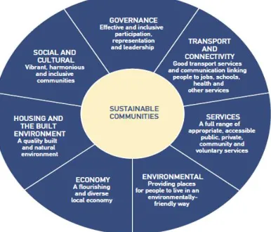
Sustainable development comprises three main sectors: social sustainability, economic sustainability, and environmental sustainability, these main sectors are linked together as illustrated in figure (1) When consider sustainability in communities these three constituent parts would be divided into seven components as( Egan [5]) shows in a simple diagram (see fig 2): Social and cultural, Governance, Environmental, Housing and the Built Environment, Transport and Connectivity, Economy and Services.
Figure 1: Scheme of sustainable development Figure 2: The seven components of a sustainable community
(Flint [6]) introduced diverse range of sustainable community development methods such as: assessing community needs and resources; creating community visions; promoting stakeholder interest and participation; analyzing community problems; designing and facilitating strategic planning.
Furthermore, social sustainability can be divided into five sectors: Equity, Diversity, Quality of Life, Government Democracy and Inter-Connectedness.( Mega [8]) argued that it is at the local level , the level closer to each citizen, that the results of sustainable development policies , reconciling economic efficiency, social equity, and ecological objectives, are ultimately felt and judged.
This is where national strategies confront local priorities and competitive pressures meet social ne eds. This is the level at which environmental problems affect human health and quality of life. That local level can be a neighborhood where the interaction of sustainable factors can be noticeable and clear. Designing a certain development should begin by analyzing the potential of the existing site, every site has its own unique climate and character; a sustainable urban neighborhood is designed to enhance those features’. Successful sustainable development also meets the needs of the community that means including the community’s culture and character in the site analysis.
(Strong [9]) highlighted some points that a sustainable urban neighborhood should include:
- Green Spaces: provision of a variety of green spaces and urban forests within the neighborhood. - Sustainable drain system: green routes can also function as a natural means of storm water drainage. This is less expensive than conventional storm water systems and a natural method for wastewater reclamation.
- Urban Mobility: Minimizing the width of vehicular routes and creates separate lanes for bicycle routes and sidewalks adjacent to vehicular routes.
-Walk ability: provision of a public transit stop within walking distance, approximately one-half mile.
- Access to social services: location of social services within walking distance, they will bring sufficient amount of businesses and keeps the area active throughout the day.
- Employment and Income generation: Provision of manufacturing and light industry, that create products required by the neighborhood or utilize waste products generated within the neighborhood.
As claimed by (Davis [10]) more attention must be given to “densification” and the housing types, location decisions and infrastructural investments that can keep settlements compact and more energy efficient. Assessment of sustainability require a very clear vision of what sustainability means and translation of this vision into criteria assessment process then asks whether these ‘sustainability criteria’ are met, If yes, then sustainable, If not, then not sustainable. (Pope [11]) argued that sustainability assessment is a confusing terminology and it is used to describe a range of different processes but its aim is so clear as it is used to help decision-makers and policy-makers decide what actions they should take and should not take in an attempt to make society more sustainable.
2. Objective of the research
3. Methodology of Case Study
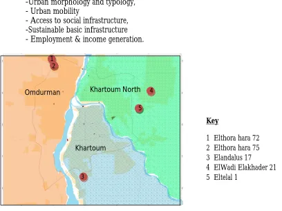
This study is based on literature and field survey. The field survey was carried out in five low-cost housing projects located in Khartoum –the capital of Sudan (see figure (1)); the capital Khartoum comprises three towns: Khartoum, Omdurman and Khartoum North. The selected housing projects are: Elthora hara 75, Elthora hara 72, Eltelal 1, El Wadi Elakhader 21 and Elandalas 17. The field study was divided into two parts: Firstly on site observation of urban morphology and Secondly, interviews to house owners and the community administrative representatives. Initial data were obtained from the data base of Khartoum State Fund for Housing and Development to identify the selected housing projects, regulations to obtain houses and information on acquisition of land, construction of houses and financing of projects. In order to analyze the housing projects of the five selected examples-adopting (Rossi’s., [12]) methodology-six parameters of urban sustainability were used. The selected urban parameters are:
-Political management and community participation, -Urban morphology and typology,
- Urban mobility
- Access to social infrastructure, -Sustainable basic infrastructure - Employment & income generation.
Figure 1: Location plan of the selected neighborhoods
4. Khartoum housing and development fund
Khartoum housing and development fund was developed from a unit in Ministry of Physical Planning to a separate institution in December 2001.The main objective of the fund to give direct support to low income families by providing housing with minimum structure (core unit) for eligible families according to specific selection criteria (pointssystem). Afterwards the idea was developed and new dwellings types are introduced which are affordable for other sectors of the community e.g. economic housing and developed housing.
Key
1 Elthora hara 72 2 Elthora hara 75
3 Elandalus 17 4 ElWadi Elakhader 21
5 Eltelal 1 1
2
3
4
5 Khartoum North Omdurman
Nowadays, Khartoum housing and development fund is facing important constraints such as Deficiencies in infrastructures, in appropriate policies, and the financial and technical weaknesses of local institutions that hindering the potential for progress
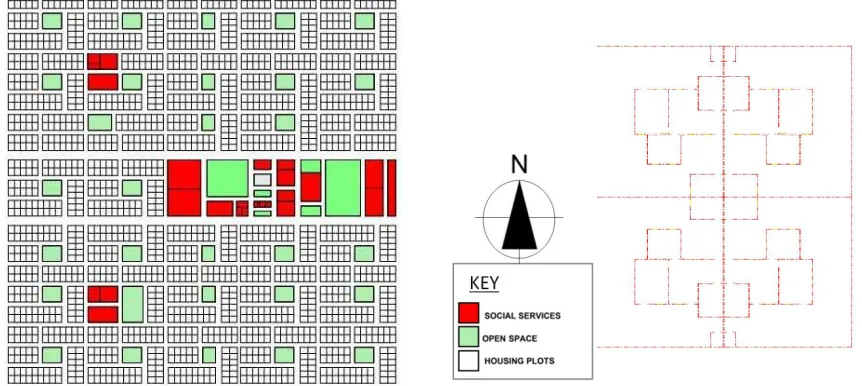
Type (1): Low- cost House: A core unit consists of a room – a kitchen –a toilet and a fence. The
plot area is 300m2 and the core built area is 30m2. The built area incrementally developed through time to a complete house of two bedrooms, a saloon, a hall, a kitchen and a toilet (see figure (2) and figure (3)).
Type (2): Economic House: A core unit of type (1) for families who don’t meet the rules of the
specific selection criteria in type (1).
Type (3): developed House: A villa consists of two rooms, a kitchen, an indoor bathroom and a
living area. The lay-out of the house is compact and the structure can be extended vertically. It is optional in some projects.
Figure 2: Clustering of low-cost houses Figure (3): Core unit plan
Photo 1: View of a cluster of low-cost houses Photo (2): View inside a low-cost house
5. Presentation of the case studies
5.1. Elthora hara 72
Elthora hara 72 is located North-West of Omdurman town, in Karari locality. The population of Karari is 1032453 in an area of 34730 hectare. The neighborhood distance from Khartoum center is 18.200 km and Omderman center “al souq alshaabi” is 10.800 km, the nearest farming area is 6.200 km and the nearest industrial area is 8.300 km. The planning pattern of the neighborhood is a systematic grid-iron with a main service centre in the middle of the neighborhood and two other sub-centers (see figure (4)).
20 m
15 m Saloo Bedroom
Hall Bedroom
Kitch Bath
Saloon
The construction of the project started in 2006 and the distribution of dwellings started in 2008. By the end of 2015, 92% of the neighborhood is built. The neighborhood contains 1164dwellings, 53% of the project is low -cost housing (see photo (3)), and 33% of the project is economic housing and only 14% of the project is developed housing (see photo (4)). 85% of the houses were distributed using the earning points system mentioned earlier, the other 15% are distributed to governmental employees. The public social services are: one basic school for boys , one basic school for girls’, one security point and a small shopping center, the privately owned social services are: two basic schools and four kindergartens. The neighborhood also contains eight mosques that have been built by public participation.
Figure 4: Site plan of Elthora hara 72
Photo 3: View of Type (3):a low-cost house Photo (4): View of Type (1):a developed house
5.2. Elthora hara 75
Elthora hara 75 is located North- West of Omdurman town, in Karari locality. The population of Karari is 1032453 in an area of 34730 hectare. The neighborhood distance from Khartoum center is 19.500 km and Omderman center “al souq alshaabi” is 12.100 km, the nearest farming area is 7.500 km and the nearest industrial area is 9.600 km. The planning pattern of the neighborhood is a grid-iron with three service centers distributed evenly in the neighborhood (see figure (5)).
The construction of the project started in 2004 and the distribution of the dwellings started in 2007. By the end of 2013, 85% of the neighborhood is built. The neighborhood contains 3600dwellings, 69% of the project is low -cost housing, and31% of the project is economic housing and 89% of the houses were distributed using the earning points system mentioned earlier, the other 11% are distributed to governmental employees.
The public social services are: two basic schools for boys , two basic schools for girls’, and one health center, the privately owned social services are: one health center, 8 schools and 4 youth clubs. The neighborhood also contains 10 mosques that have been built by public participation. The majority of the residents are low- income groups who find job opportunities at the small market next to the neighborhood at the last bus station.
Figure 5: Site plan of Elthora hara 75
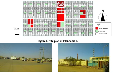
5.3. Elandalus 17
Elandalus block 17 is located South- West of Khartoum town in Jabal awlia locality; the population of Jabal awlia is 1382380 in an area of 61061 hectare. The neighborhood distance from Khartoum state center is 16.000 km, the nearest farming area is 4.700 km and the nearest industrial area 5.600 km. The planning pattern of the neighborhood is a systematic grid-iron with the main service centre in the middle of the neighborhood (see figure (6)). The construction of the project started in 1997. By the end of 2012, the neighborhood is completely built. The neighborhood contains 2421dwellings, 40% of the project is low -cost housing, and 60% of the project is economic housing. 98% of the houses were distributed using the earning points system mentioned earlier, the other 2% are distributed to governmental employees. The public social services are: two basic schools for boys (see photo (5)), two basic schools for girls, one secondary school for girls, two security points, one club and one health centre and the privately owned social services are: two health centers and two basic schools . The neighborhood also contains four mosques that have been built by public participation.
The nearest work center is in alkalakla sharig -last bus station (see photo (6)), which includes a shopping area, bus-terminal and some light industries so that a great number of local inhabitants employed there.
Figure 6: Site plan of Elandalus 17
Photo 5: View of the basic school of the boys Photo (6): View of the shopping area in alkalakla sharig - last bus station
5.4. ElWadi Elakhader 21
ElWadi Elakhader block 21 is located North-East of Khartoum North town in Sharg Elnile locality, the population of Sharg Elnile is 1343955 in an area of 799704 hectare. The neighborhood distance from Khartoum North center is 20.400 km, the nearest farming area is 5.800 km and the nearest industrial area 17.450 km. The planning pattern of the neighborhood is a systematic grid-iron with the main service centre in the middle of the neighborhood (see figure (7).The construction of the project started in 2006 and the distribution of dwellings started in 2008. By the end of 2015, 85% of the neighborhood is built. The neighborhood contains 1084dwellings, 58% of the project is low -cost housing (see photo (8)), 37% of the project is economic housing and only5% of the project is developed housing. All houses were distributed using the earning points system..
The public social services are: one basic school for boys, a small shopping center, and one security point, as for the rest of the social services they are privately owned (two health centers, four basic schools, two secondary schools and one club. The neighborhood also contains six mosques that have been built by public participation. The majority of the inhabitants find jobs in the small shopping area inside the neighborhood (see photo (9)), the block factory and the sweet factory and also at the nearby shopping center at Hilat Kuku.
Figure 7: Site plan of ElWadi Elakhader 21
Photo 8: View of the street of the developed Photo (9): View of the shopping area housing
5.5 Eltelal 1
Etelal 1 is located north- East of Khartoum North town in Sharg Elnile locality. The population of Sharg Elnile is 1343955 in an area of 799704 hectare. The neighborhood distance from Khartoum North center is 17.000 km.The nearest farming area is 2.600 km and the nearest industrial area is13.700 km.
The planning pattern of the neighborhood is a systematic grid-iron with two service centers in the middle of the neighborhood (see figure (8)).The construction of the project started in 2003 and the distribution of dwellings started in 2005. By the end of 2015, 85% of the neighborhood is built. The neighborhood contains 784,251dwellings, 70% of the project is low - cost housing (see photo (10)), and 30% of the project is economic housing. . All houses were distributed using the earning points system.
The public social services are: one basic school for boys and one basic school for girls, and the privately owned social services are one health center (see photo (11)) and one youth club. The neighborhood also contains 10 mosques that have been built by public participation.
Figure 8: Site plan of Eltelal 1
Photo 10: View of the unpaved streets of Photo (11): View of the private health centre
6. Summary of the findings
General data Elthora hara
72
Elthora hara 75
Elandalas 17
El Wadi Elakhader 21
Eltelal 1
town Omdurman Omdurman Khartoum Khartoum North Khartoum
North
Localization Karari Karari Jabal awlia Sharg Elnile Sharg Elnile
Start of construction 2006 2004 1997 2006 2003
Area of the neighborhood ( m2)
1,620,125 2,139,223 970,920 683,280 573,552
Inhabitants of the neighborhood
11,817 23,400 15,737 4,381 5,096
Population density (m2 /person)
137.10 91.40 61.70 155.90 112.50
Distance from town center (km)
10.800 12.100 16.00 20.400 17.00
Acquisition of land Public sector Public sector Public sector Public sector Public sector
Urban design Public sector Public sector Public sector Public sector Public sector
Construction materials Cement brick Cement brick red brick Cement brick Cement brick
Financing The fund The fund The fund The fund The fund
Community participation yes yes yes yes yes
Mixed land-use No No No Yes Yes
Social mixture Yes Yes Yes Yes Yes
Mixed housing Yes Yes No Yes No
houses 54% 52% 54% 56% 48%
streets 33% 36% 33% 31% 39%
open spaces 9% 8% 7% 6% 6%
Social services 4% 4% 6% 7% 7%
Public transportation-Bus Yes Yes Yes Yes Yes
Car ownership 25% 30% 25% 27% 20%
Bicycle paths No No No No No
Pedestrian ways No No No No No
Road hierarchy Yes Yes Yes Yes Yes
Paved roads Yes Yes Yes Yes Yes
Public schools Yes Yes Yes Yes Yes
Public health services No Yes Yes No No
Recreation facilities-clubs Yes Yes Yes Yes Yes
Religious facilities Yes Yes Yes Yes Yes
Shopping area Yes No Yes Yes No
Security point Yes No Yes Yes No
Rainwater drainage system Man made natural Man made Man made Man made
Sewage system private private Shared wells private private
Water supply On site On site network On site One site
Garbage collection yes yes No No No
Electricity network network network network network
7. Analysis of the parameters of urban sustainability of the selected neighborhoods
7.1. General data of the selected neighborhoods
The Population density in all the selected projects is related with the date of construction ,as the eldest project - Elandalas 17-has the highest population density i.e. 61.70m 2 per person which matches with the recommended UN habitat optimum density for sustainable neighborhoods(UN Habitat [13]), which is 66 m2 /person. Two projects only have optimum number of inhabitants (El Wadi Elakhader 21 and Eltelal 1) 4,000-5,000 people which matches with the neighborhood concept, the other projects have large number of inhabitants , they can be distributed in more than one neighborhood. All the selected projects have peripheral locations, the nearest project is Elthora hara 72 which is 10.800 Km from Omdurman centre and the furthest is El Wadi Elakhader which is 20.400 Km from Khartoum North centre. Inhabitants of these projects suffer because these areas are isolated from work and they are not accessible to higher level of social services e.g. secondary schools.
7.2. Political management and community participation:
Acquisition of Land for the selected projects is from the public sector- land department. The urban design of the projects is prepared by the Ministry of Physical Planning and the construction by contractors from the private sector. The involvement of the private sector caused a faster pace in completing the projects due to competition between the contractors; but also made room for negligence and poor performance. The public sector funds the construction of the projects which will usually be subsidized. Community participation doesn’t involve in the planning and construction process but it plays a significant role in providing social services especially mosques.
7.3. Urban morphology and typology:
Two neighborhoods only have mixed land-uses, El Wadi Elakhader 21 has a developed shopping area in the centre of the neighborhood which provides job opportunities for the local inhabitants, and Eltelal 1 has 3 sweets factories in the neighborhood .The inhabitants of the other neighborhoods work in nearby central areas. Despite the fact that these projects are mainly developed for low-income families, but most of the projects have social mixture of inhabitants of different income levels, hence The Fund offers other types of housing: economic housing and developed housing for middle-income families. There is no mixed housing typology as the dominant housing type in all projects is the semi-detached house with a few portions of single detached houses.
As for the land uses, street networks and open spaces altogether represent 39% -45% of the total area of the neighborhood , which is higher than UN habitat recommendation (UN Habitat [13])for sustainable neighborhoods planning that street network and open spaces should occupy 30% of the total area of the neighborhood .Open spaces in all the projects are few, they represent a small portion of the total area of the neighborhoods ranging from6 % in Eltelal 1 to 9% in Elthora hara 72.and they are bare of green areas and not developed.
7.4. Urban mobility:
7.5. Access to social infrastructure:
Public social services are provided in all neighborhoods according to the local need, but they are not sufficient in number and level. Other social services are provided by private sector e.g. schools, health centers and clubs as an investment. All the projects have shopping areas and security point within the neighborhoods except Eltelal 1 and Elthora hara 75.
7.6. Sustainable basic infrastructure:
There are no sustainable solutions used in providing basic structures for all the selected projects. Basic infrastructures are provided for the selected projects as follows:
Water supply network connection is synchronized with the construction process and in some projects prior to the construction of the houses. Geophysical studies are conducted to locate the nearest underground water source, then water wells, tankers, pumps and generators are used to supply the designated area, each project is supervised by specialized contractors.
Surface drainage is provided in major roads only surrounding all the selected projects except Elthora hara 75which has a natural drainage from the seasonal torrents that is connected with a large draining trenches surrounding the neighborhood from all directions. Earthen barriers are assembled around some projects that are located in low lands e.g Eltelal 1and Alwadi Elakhader 21 as a precautionary act against seasonal rain floods.
-Communal drainage system is implemented only in Elandalas 17 , houses are sharing septic tanks and wells located in the adjacent open spaces. Other selected projects have traditional pit latrines.
Garbage is collected in two projects only (Elthora hara 72 and Elthora hara 75) by municipal cars in specific days in the week and treated outside the neighborhoods.
-Electricity, as main source of energy, has been connected to all selected projects with the main network, the local authorities provide all materials needed and contractors are used only to assemble them.
7.7. Employment and income generation:
Labor market is not relatively far from the selected projects, the nearest farming area is 2.00 km and the furthest is 6.1km and the nearest industrial area is 5.60 km and the furthest is 17.40 km.
7. Conclusion and recommendations
-Today, however Khartoum boundaries are being extended through the mass production of housing. There are relatively few available lots in well-serviced areas of the capital, while high land costs in central areas make public authority unwilling to try to build housing projects in denser locations. This is why mass production of low -cost housing usually selects peripheral locations that should raise warning bells: Not enough attention is being given to location decisions, “densification” and the housing types, that can keep cities compact.
- The decision to locate these projects in remote areas helps achieve savings on land prices at the neighborhood level but housing-led sprawl has produced growing demands for public investment in urban services that are straining budgets at the national level.
-Most of the selected projects are likely lack good transport connectivity with other parts of the capital or sufficient social services. Neither developers nor public authorities are eager to pay for the infrastructure that would make these projects live able, let alone sustainable, particularly in the case of social services. Uncompleted provision of public social services makes room for the private sector to fill the gap by providing schools; health centers etc. that burden the low –income inhabitants of these projects. Many of low- income families who end up in these projects continue to suffer because these areas are both isolated and under-serviced. Further, they continue to live in areas where the daily quality of life may affect their satisfaction with their houses.
8. Recommendations
In order to promote sustainable housing within a framework of a sustainable neighborhood the most important steps are:
8.1. Location of the selected projects: Choose accessible locations for low- cost housing projects,
and reserve land especially for that use (and thus by protecting it from competition from other possible uses) this is not a hard task because more than 90% of land in Sudan is owned by the public sector. The costs of making that land available, possible some of the costs also of building the housing, will usually be subsidized.
8.2. Political management and community participation: Invite inhabitants to act as partners
and try to bring together local inhabitants and public authorities in order to build consensus on a vision for the future of their neighborhoods. Design innovative communication patterns and co-operation schemes for the community participation- A non-participatory society’s inherently unsustainable.
Promote land-use planning system in a particular way in order to make the private sector involved in financing low cost housing projects together with the public funds. Involve urban planners in the monitoring and regulating housing production that will make housing decisions is connected to existent infrastructure in ways that help create more efficient and sustainable urbanism.
8.3. Urban morphology and typology: Ensure that there is a social mixture of inhabitant,
encourage families to use part of their houses for other uses such as commercial to improve family income, keep inhabitants near their homes and make the neighborhood mixed-use.
–
-Encourage sustainable urban mobility and give priority to pedestrians, cyclists, and public transport, as it is an important strategy for decreasing carbon emissions in cities and regions.
-Introduce Shared-use mobility services such as car sharing, which was once used in Sudan.
-Design street network to achieve the following aspects:
Streets are walk able and cyclist friendly, improve transportation connectivity, road hierarchy is highly interconnected and sufficient parking space is provided.
8.4. Access to social infrastructure: Provide suitable social services; consider carefully the
appropriate number and level of the service compared to the number of users according to the international standard. Wherever, there is deficiency in budgets, invite public participation to engage.
8.5. Sustainable basic infrastructure: Encourage provision of sustainable basic infrastructure
especially solar energy as there is a good opportunity to use it; hence Sudan enjoys a lot of sunny days and has successful experiments of utilizing solar energy in domestic use- that is cheaper than the conventional ways of energy generation. Introduce more healthy and sustainable methods of drainage systems and make use of international experience of similar developing countries e. g. India.
8.6. Employment and income generation: Connect housing with work and introduce new work
sites such as farms and light industry near to remote housing projects. Encourage families to be productive by using part of their houses- as plot size is relatively large- to generate income e.g. growing vegetables and looking after some domestic animals, by doing so the neighborhood as a whole will has benefit.
9. References
The United Nations.. The Global Goals for Sustainable Development. 2013. Retreived from http://www.globalgoals.org/global-goals/sustainable-cities-and-communities.
UN Habitat. The Future We Want. June 2012.Retreived from ww.un.org /disabilities /document /rio20_outcome_document_
Gardner, G and Yates, E..Equity can help cities win the sustainability race. Retreived from http://citiscope.org/habitatIII. 2016.
Lepuschitz,K.(). Integrating SDGs into national SD policy frameworks and governance structures Activities in 4 selected
EU Member States. European Sustainable Development Network. 2015
Egan. J. The Egan Review: Skills for Sustainable Communities. london. RIBA Enterprises Ltd .pp19. 2003 Flint,R.W. Practice of sustainable community development. New York .Springer science +Business Media. 2013 Scruggs, G.. (Connecting housing with sustainable urbanization in the New Urban Agenda) citiscope. April 2015 Mega,V.. Urban Dimensions of Sustainable Development . Human Settlement Development - Vol. IV –2007 Strong, K.S.. (Sustainable Urban Neighborhoods) .Unpublished Thesis - partial fulfillment of the requirements
for the degree of Master of Science in architectural studies University of Florida. Florida. U.S.A. 2001 Davis, D.E. (Habitat III must rethink the role of housing in sustainable urbanization). Citiscope.october 2015.
Pope, J. Sustainability Assessment: What is it and how do we do it?In: International Sustainability Conference, 17 - 19 September, Fremantle, Western Australia. 2003
Rossi.G., Barbosa G.and Aragão,T. Sustainable Neighbourhoods and Social Housing Urban Projects: A Comparison
between Brazilian and European Practices. In Proceedings of the World Congress on municipal
engineering and Sustainable Communities. 2012. Retreved from http://www.laburb.poli.ufrj.br/publicacoes.