392
Localization Error Minimization Based on Effective Wireless Technique in
Wireless Sensor Networks
Meenkshi Parashar1
M. Tech. Scholar, Department of EC BTIRT, Sagar (M.P), India [email protected]
Prof. Megha Soni2
Asst. Professor, Department of EC BTIRT, Sagar (M.P), India
Abstract: Effective wireless sensor network technique is new approach based on minimize error in data communication in WSN. Wireless sensor networks is much needed as many important services of WSN are used in different fields to perform various tasks such as search, rescue operations, critical operations target following in objects as nodes and different tasks in good environments and coverage. Localization algorithmic is needed for tiny structures supported wireless network and network’s position reportage system. This work aims at determining the situation of the sensor nodes with high correctness and without fault in WSN communication. The initial a part of this work is dole out by localizing the nodes exploitation mobile anchor node Positioning, a range-based localization technique. The localization algorithmic supported the vary is largely finding purpose estimations by knowing a minimum of position value of anchor node that is to put up with in intelligence of absolute position value within the location network in sensor nodes are fastened in WSN Proposed algorithm is used to measure a distance and angle of the direction of various sensor nodes using the number of anchors. Then get the optimum location by minimizing the fault and obtaining the optimum solution. Basic challenges in a wireless sensor network are node localization. In used proposed algorithm for node localization discovery in wireless sensor networks and minimizing the fault in WSN.
Keywords: Wireless Sensor Network, AOA, Global Positioning System, RSS, Sensor Network, Localization, Network Mobility, Mobile Anchor Positioning.
I. INTRODUCTION
Wireless communication technology has enabled the growth of comparatively economical and low power sensors. The general goal is to make wireless sensor network that is capable to sense the surroundings, compute some task and communicate with each other to attain some objective like monitoring some phenomenon, target tracking, forest fire detection, and battlefield surveillance [1]. In the majority of the applications, location information of each node in the network is needed. However, in a large amount of cases, sensor nodes are deployed randomly right through some region. Thus, the first task is to find out the location of the nodes. To find out the physical location of sensor node in WSN is a crucial problem because of its use in first identification of the origin of sensor reading, second energy aware geographic routing, third self organization and self configuration of networks. Apart from the above,
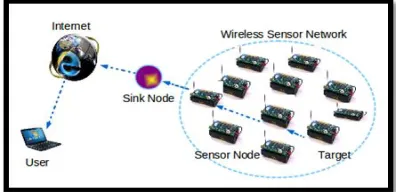
in various applications, the location itself is information of interest [2]. There is one easy way i.e. manual configuration but this is impractical for large scale deployment. The simple wireless sensor network is shown in figure 1.1 Sensor network node location information is important for numerous reasons. In different cases, the sensed information or data has no value without the position information. The location information can be used by routing and other protocols and services, method. Equipping nodes with GPS receivers is not a suitable option because GPS receivers require line of sight to GPS satellites. Moreover, GPS is costly and power hungry. Therefore for the randomly deployed sensor networks, various localization, method have been introduced where only a small number of sensor nodes are equipped with GPS receivers and other sensor nodes get their locations by using the localizations, methods [1].
Figure 1 Sensor network node locations
Characteristics of WSN
Wireless Sensor Network is at present used for real-world unattended physical locations to measure numerous parameters. So, the characteristics of Wireless Sensor Network must be considered for well-organized employment of the network. The important characteristics of Wireless Sensor Network are described as follows [3] Low cost: in the Wireless Sensor Network normally hundreds or thousands of sensor nodes are deployed to measure any physical environment. In order to reduce the overall cost of the entire network the cost of the sensor node must be kept as low as possible.
393 different algorithm development should regard as the power use in the design phase.
Computational power: normally the node has limited computational capabilities as the cost and energy need to be considered. Communication network Capabilities: Wireless device Network usually communicates victimization radio waves over a wireless channel. It’s the property of act briefly vary, with slim and dynamic information measure. Communication between completely different channels will be either bidirectional or unidirectional. With the unattended and hostile operational environment it is difficult to run Wireless Sensor Network smoothly. Hardware and software used for communication should have regard to the security. Security and Privacy: Each sensor node should have sufficient security mechanisms in order to prevent unauthorized access, attacks, and unintentional damage of the information inside the sensor node. Furthermore, additional privacy mechanisms must also be included. Distributed sensing: numbers of sensor nodes are spread uniformly and randomly. In Wireless Sensor Network each node is capable of collecting, sorting, processing, aggregating and sending the information to the sink. Then the distributed sensing gives the strength of the scheme. Dynamic network topology: In general, Wireless Sensor Network is a dynamic network. The sensor node cannot succeed for battery overtiredness or other conditions, communication between different channels can be disrupted as well as the extra sensor node may be extra to the network that results in the frequent changes in the network topology. Thus, the Wireless Sensor Network nodes have to be embedded with the purpose of reconfiguration, self-adjustment. Self-organization: the sensor nodes in the network must have the capability of organizing themselves as the sensor nodes are deployed in an unknown fashion and hostile environment. The sensor nodes have to work in collaboration to change algorithm and form the network automatically.
Multi-hop communication: a large number of sensor nodes are deployed in WSN. So, the feasible way to communicate with the sinker or base station is to take the help of an intermediate node through routing path. If one needs to communicate with the other node or base station which is beyond its radio frequency it must me through the multi-hop route by intermediate node [3]. Types of Localization Schemes
Range-based method and range-free method are discussed
1. Range-Free Methods: Range-free methods (RFM) are used to measure distance vector hop and hop terrain. RFM use centroids system, APIT, and rise algorithm. RFM use radio connectivity to communicate between nodes to infer their location. In RFM, distance measurement, AOA, and special hardware are not used.
A.DV Hop: DV hop estimates range between nodes using hop count. Minimum 3 anchor nodes transmit
coordinates with hop count across the network. The information propagates across the network from neighbor to neighbor node. When neighbor node receives such information, hop count is incremented by one. In this way, unlocalized node can find number of hops away from anchor node (AN). All AN calculate shortest path from other nodes, and unlocalized nodes also calculate direct path from all AN. Average hop distance formula is calculated as follows: distance between two nodes or number of hops. Nameless nodes use triangulation method to estimate their positions from three or more anchor nodes using hop count to measure direct distance.
Hop Terrain: Hop terrain is similar to DV hop method used for finding the distance between anchor node and unlocalized node. There are two parts in the method. In the first branch, unlocalized node estimates its position from anchor node by using average hop distance formula which is distance between two nodes or total numbers of hops. This is initial position estimation. After initial position estimation, the second part executes, in which initial estimated position is broadcast to neighbor nodes. Neighbor nodes receive this information with distance information. A node refines its position until final position is met by using least square method.
Centroid System: Centroids system uses proximity based grained localization algorithm that uses multiple anchor nodes, which broadcast their locations with ( , ) coordinates. After receiving information, unlocalized nodes estimate their positions are randomly deployed in the network area, and they localize themselves from beginning to end GPS receiver [13]. Node localizes itself after receiving anchor node beacon signals using the following formula: ( est, est) = ( , + ⋅ ⋅ ⋅ +, , , + ⋅ ⋅ ⋅ +, ) ,(1), where est and est are the estimated locations of unlocalized node.
AP-IT: In approximate purpose in triangulation theme (AP-IT), anchor nodes get location data from GPS or transmitters. Unlocalized node gets location data from overlapping triangles. The realm is split into overlapping triangles. In APIT, the subsequent four steps are enclosed.
(i) Unlocalized nodes: maintain table once receiving beacon messages from anchor nodes. The table contains data of anchor ID, location, and signal strength.
(ii) Unlocalized nodes select any three anchor nodes from area and check whether they are in triangle form. This test is called point in triangulation test.
(iii) PIT test continue until accuracy of unlocalized node location is found by combination of any three anchor nodes.
(iv)The end, center of gravity is calculated, it is intersection of all triangles where an unlocalized node is located to find its estimated position.
Gradient Algorithm: In gradient technique,
394 localized nodes to estimate their positions from 3 anchor nodes by victimization multilateration. It additionally uses hop count price that is at the start set to zero and incremented once it propagates to alternative neighboring nodes.. It also uses hop count value which is initially set to 0 and incremented when it propagates to other neighboring nodes. Each sensor node takes information or data of the direct path from AN. Gradient algorithm follows few steps such as the following:- (1) In the first step, anchor node broadcasts beacon message containing its coordinate and hop count value. (2) In the second step, unlocalized node calculates shortest path between itself and the anchor node from which it receives beacon signals. To calculate estimated distance between anchor node and unlocalized node, the following mathematical equation is used [27]: = ℎ ,
hop, (2) where hop is the estimated distance covered
by one hop. (3) In the third step, error equation is used to get minimum error in which node calculates its coordinate by using multilateration as follows: = ∑ ( −), (3) =1, Where is the estimated distance computed through gradient propagation.
2. Range-Based Localization: Range-based schemes are distance-estimation- and angle-estimation-based techniques. Vital method used in RFM localization are received signal strength and indication (RSSI), angle of arrival (AOA), time difference of arrival (TDOA), and time of arrival (TOA).
Received Signal Strength Indication (RSSI): In RSSI, distance between transmitter and receiver is estimated by measuring signal strength at the receiver. Propagation loss is also calculated, and it is converted into distance estimation. As the distance between transmitter and receivers increases, power of signal strength decreases. This is measured by RSSI victimization the subsequent equation:
Angle of Arrival (AOA): Unlocalized node location may be calculable victimization angle of 2 anchors signals. These are the angles at that the anchors signals are received by the unlocalized nodes. Unlocalized nodes use triangulation methodology to estimate their locations. Time Difference of Arrival (TDOA): In this technique, the time difference of arrival of radio and ultrasound signal is used. Each node is equipped with microphone and speaker. Anchor node sends signals and waits for some fixed amount of time which is delay, and then it generates “chirps” with the help of speaker. Different signals are received by unlocalized node at time. When unlocalized node receives anchor nodes radio signals, it turns on microphone. When microphone detects chirps sent by anchor node, unlocalized node saves the time of sound. Unlocalized node uses this time information for calculating the distance between anchor and itself. Time of Arrival (TOA):In TOA, speed of wavelength and time of radio signals travelling between anchor node and unlocalized node is measured to estimate the location of unlocalized node. GPS uses TOA, and it is a highly
accurate technique however, it requires high processing capability. Some interesting outcomes are generated by comparing few localization techniques. The outcomes are based on our explanation and analysis. Cost of four localization techniques and it is observed that GPS- and TOA-based systems are more costly as compared with DV hop and RSS. It is experimental that localization mechanisms equipped with GPS systems are highly accurate. Such mechanisms are needed for WSNs, which are energy efficient comparison of energy efficiency of different localization mechanisms GPS-based localization mechanisms are less energy efficient while RSSI-based mechanisms are highly energy efficient [4].
II. LITERATURE REVIEW
A. Kulaib et al. [5]. the distance-based localization techniques are surveyed for WSNs. It is impossible to present a complete review of every published algorithm. Therefore, ten representative distance-based localization algorithms that have diverse characteristics and methods are chosen and presented in detail. The authors outline a tiered classification mechanism in which the localization techniques are classified as distributed, distributed-centralized, or centralized. Generally, centralized localization algorithms produce better location estimates than distributed and distributed-centralized algorithms. However, much more energy is consumed in the centralized algorithms due to high communication overheads for packet transmission to the base station. Distributed-centralized localization algorithms are always used in cluster-based WSNs, which can produce more accurate location estimates than distributed algorithms without significantly increasing energy consumption or sacrificing scalability. Localization of sensor nodes is an important aspect in Wireless Sensor Networks (WSNs). This paper presents an overview of the major localization techniques for WSNs. These techniques are classified into centralized and distributed depending on where the computational effort is carried out. The paper concentrates on the factors that require to be thought-about once choosing a localization technique. The benefits and limitation of varied techniques are mentioned. Finally, future analysis directions and challenges are highlighted.
395 sensing element node design and its applications, totally different localization techniques.
Ms. Sunita et al. [7]. Sensor Networks were initially deployed for Military operations and surveillance but it emerged as a potential solution for various other fields like Environment sensing, Industrial sensing, Health and Home applications. Low cost small sensor nodes and robustness of the network allows the use of sensor network in various other fields. This paper studies the application areas of sensor network.
Sakshi Aggarwal et al. [8].Localization has become one of the mandatory services in wireless sensor networks (WSNs) while dealing with critical operations such as coverage, deployment, routing, target tracking and rescue operations. Since the need of WSN has enhanced drastically to produce best answer with correct results of sensing element nodes, it principally depends on the WSN node localization. This paper provides a summary of various approach of node localization discovery in wireless sensing element networks. A survey on numerous aspects or techniques of localization like localization error, parameters of localization, accuracy, bit error likelihood, energy consumption has been studied. Numerous overviews of the schemes planned by totally different authors for the development of localization in wireless sensing element networks are highlighted.
Sudha H.Thimmaiah et al. [9]. Wireless sensor based communication system is an ever growing sector in the industry of communication. Wireless infrastructure is a network that enables correspondence between various devices associated through an infrastructure protocol. Finding the position or location of sensor node (Localization) is an important factor in sensor network for proving efficient service to end user. The existing technique proposed so for suffers in estimating the likelihood of localization error. To cater this in this work the author proposes a RSS (Received signal strength) based localization technique and also proposes an adaptive information estimation to reduce or approximate the localization error in wireless sensor network. The author compares our proposed localization model with existing protocol and analyse its efficiency.
B. Srinivasan et al. [10].was planned that in WSN the localization was a necessary issue as a result of several applications need sensing element nodes to understand their locations with a high degree of exactness. a best path coming up with methodology for the mobile anchors supported localization. The planned path coming up with methodology determined the situation of the individual sensing element nodes with the assistance of mobile anchor nodes. It ensured that the flight of the mobile anchor nodes decreased the localization error
and secure that each one of the sensing element nodes might confirm their locations. Then, the PSO formula determined the flight of the mobile anchor nodes. the trail coming up with strategy methodology performed in each smaller localization error and a high share of localized sensing element nodes by PSO.
Shang et al. [11] presented a centralized formula supported MDS, namely, MDS-MAP(C). Initially, victimization the property or distance info, a rough estimate of relative node distances is obtained. Then, MDS is employed to get a relative map of the node positions and at last an absolute map is obtained with the assistance of anchor nodes. The initial location estimation is refined victimization least sq. technique in MDS-MAP(C, R). each techniques work well with few anchors and fairly high property.
T. He et al. [12] .Location awareness is of great importance for several wireless sensor network applications. Precise and quick self localization capability is highly desirable in wireless sensor network. Localization algorithms have been developed with various approaches. A detailed survey of localization techniques is provided in. Localization techniques can be classified as range free or range based, depending on whether the range measurement methods are used or connectivity information is used. Range based methods require range measurement information, such as Received Signal Strength Indicator (RSSI) , Angle of Arrival (AOA) , Time of Arrival (TOA) and Time Difference of Arrival (TDOA) etc. However, the measurement accuracy of these methods can be affected by the environmental interference. Though, range free methods cannot pro-vide accurate location estimation, they are cost effective and robust to noise since range measurements are not involved in it. The range-based methods have connectivity or proximity information between neighbor nodes who can communicate with each other directly.
D. He et al. [13]. Based on an attack-driven model specified with the Petri net, an enhanced secure localization scheme (ESLS) is proposed which extends the idea in [38] and defends against not only distance reduction attacks but also distance enlargement attacks. The major contribution is the first time to use the Petri net to validate a security scheme for WSNs.
396 secret shared keys between two users in an adversarial environment over an insecure communication medium. 3) Locate: the location is estimated via ToA based technique. Moreover, a double-averaging mechanism is also presented to minimize the localization error.
Nisha M.S et al. [15was projected the comparison of localization victimization centralized, distributed and PSO techniques. to scale back error throughout localization used new means that to approximate the space between unknown nodes and anchor nodes once it had been larger than node’s communication radius. Moreover, the particle swarm optimization calculate the similar position of nodes, it makes the localization error much lower than the common method.
III. SIMULATION TOOL AND RESULT ANALYSIS
1 Simulation Tool: MATLAB (matrix laboratory) is a multiparadigm numerical Computing environment. A language developed by Math Works. MATLAB allows matrix manipulations, plotting of functions and data, implementation of algorithms, creation of user interfaces and interfacing with programs written in other languages, including C, C++, Java, FORTRAN and Python. Although MATLAB is intended primarily for numerical computing, an optional tool box uses the MuPAD symbolic engine, allowing access to symbolic computing abilities. An additional package, Simulink, adds graphical multi domain simulation and model based design for dynamic and embedded systems and analysis network environment. The experiment is conducted on a laptop with Intel Dual Core processor, 4GB memory, and Window 7 Ultimate system. Here, this method is implemented and simulated on MAT LAB tool and for this work we use Intel 2.4 GHz Machine and operating system windows, window-xp etc.
2 Result Analysis: To research in the field of wireless sensor networks and identify various challenges .The graph analysis of case 1 i.e. with 9 anchor nodes has been shown below in fig showing that execution time is least for our proposed techniques EWT as compared to that in existing technique i.e. EMRSS and EMAOA.
Figure 2 Graph Analysis in Execution Timein EWT and Previous Technique EMRSS and EMAOA
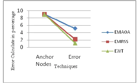
3 Graph Analysis in Evaluation of Error: The graph analysis of case 1 i.e. with 9 anchor nodes has been shown below in fig showing that the error is minimum in proposed technique EWT as compare to that in existing technique i.e. EMRSS and EMAOA.
Figure3 Graph Analysis in Evaluation of Error in EWT and Previous Technique EMRSS and EMAOA
IV. CONCLUSION
The proposed new approach is an Effective Wireless Sensor Network Technique (EWT) based on error minimization using functions in localization wireless sensor network. EWT’s objective is to minimize the localization error in wireless sensor networks. Many applications in WSNs require locations of sensor nodes. In order to get information about location, many localization schemes are proposed to automatically estimate sensors’ positions. In the case of mobile sensor networks, localization technique becomes difficult to apply because of node mobility. Thus, a simple localization scheme must be developed with the low estimated error for mobile sensor networks. Localization scheme is used in wireless sensor network to improve accuracy and minimize the error and also to reduce the computation cost and memory occupation, say the number of samples is adaptive to the estimated sampling region. The target of the proposed technique is to approximate the position or location of nodes in a wireless sensor network with minimum fault. Thus, the proposed scheme is suitable to be implemented on mat lab tool and find out the minimum error in WSN within limited time. To research in the field of wireless sensor networks and identify various challenges and overcome them and further aim to get more effect result for range free area networks by maintaining positioning of nodes.
REFERENCES
[1].J. Zhao, W. Xi, Y. He, Y. Liu, X.-Y. Li, L. Mo, and Z. Yang,”
Localization of Wireless Sensor Networks in the Wild: Pursuit of Ranging Quality,” in IEEE/ACM Transactions on Networking, vol 21, no.1,pp 311-323,Feb 2013.
[2].Chee-Yee Chong; Kumar, S.P., "Sensor networks:
397
[3].Gowrishankar.S, T.G.Basavaraju , Manjaiah D.H, Subir
Kumar Sarkar , “Issues in Wireless Sensor Networks”, Proceedings of the World Congress on Engineering 2008 Vol I WCE 2008, July 2 - 4, London, U.K., 2008.
[4].Amanpreet Kaur, Padam Kumar, Govind P Gupta,
“Localization in Wireless Sensor Networks: A survey”, International Journal of Innovations & Advancement in Computer Science IJIACS ISSN 2347 – 8616 Volume 5, Issue 11 November 2016.
[5].Long Cheng, ChengdongWu, Yunzhou Zhang, HaoWu,
Mengxin Li, and CarstenMaple, “A Survey of Localization in Wireless Sensor Network”, International Journal of Distributed Sensor Networks, November 2012.
[6].Jyothi N S, Monica R Mundada, “localization technique
for wireless sensor networks”, International Journal of Engineering and Technical Research (IJETR) ISSN: 2321-0869, Volume-3, Issue-1, January 2015.
[7].Ms. Sunita ,Jyoti Malik ,Suman Mor, “ Comprehensive
Study of Applications of Wireless Sensor Network”, International Journal of Advanced Research in Computer Science and Software Engineering, Volume 2, Issue 11, November 2012.
[8].Sakshi Aggarwal, Vikas Gupta, “Localization in Wireless
Sensor Networks”, International Journal of Advanced Research in Electronics and Communication Engineering (IJARECE) Volume 5, Issue 5, May 2016.
[9].Sudha H.Thimmaiah, Dr. Mahadevan.G., “An Adaptive
localization error minimization approach For wireless sensor network”, IEEE, 2016.
[10].P. sangeetha and B. Srinivasan, “ Mobile Anchor-Based
localization Using PSO and Path Planning Algorithm In Wireless Sensor Networks”, IJIRAS, Vol. 2, pp 5-8, 2015.
[11].Y. Shang, W Ruml, Y. Zhang and M. Fromherz,
“Local-ization from Connectivity in Sensor Networks,” IEEE Transactions on Parallel and Distributed Systems, Vol. 15, No. 11, pp. 961-974, 2004.
[12].T. He, C. Huang, B. Blum, J. Stankovic and T.
Abdelza-her, “Range-Free Localization Schemes for Large Scale Sensor Networks,” Proceedings of the Ninth Annual In-ternational Conference on Mobile Computing and Net-working (ACM Mobicom), San Diego, September 2003, pp. 81-95.
[13].D. He, L. Cui, and H. Huang, “Design and verification of
enhanced secure localization scheme in wireless sensor networks,” in IEEE transactions on Parallel and Distributed Systems, vol. 20, no. 7, July 2009.
[14].S. Arisar and A. Kemp, “Secure location estimation in
large scale wireless sensor networks,” in Proceedings of the 3rd International Conference on Next Generation Mobile Applications, Services and Technologies, 2009, pp. 472– 476.
[15].G. Nair and Nisha M.S, “Localization of Sensor Nodes in
Wireless Sensor Network”, ICACCTHPA, pp 40-43, 2014.
[16].Theodoros Fronimos, Loukas Petrou, George Hassapis,