Climate Data Record (CDR) Program
Technical Report
International Surface Temperature Initiative
Global Land Surface Databank
Version 1.1.0
1. Introduction
The purpose of this document is to provide an update to the International Surface
Temperature Initiative’s (ISTI) global land surface temperature databank. This dataset
contains global monthly mean temperature (maximum, minimum, and mean) on multiple
time scales. Data are collected from in situ networks as well as other national and
international providers. The ISTI Steering Committee was formed in 2010 and they
convened a Databank Working Group (DWG) to oversee the development and
management of the databank. The process builds on past efforts to construct a new
global land surface dataset, paying special attention to ensuring users can fully
understand the provenance of the data in the merged holding to the extent that it is
known.
In June 2014, the first version of the global databank was released (Rennie et al., 2014), which included data from nearly 50 different sources and an algorithm to resolve
duplicate stations and piece together complete temperature time series. Since then,
there have been monthly updates, appending new data to existing stations. Thanks to
user feedback, along with additional analysis, minor changes were introduced and
implemented to the merge program to ensure the most accurate data were incorporated
in the final product. This, along with updates to current sources required a small change
to the versioning system. The remainder of this document will highlight the changes
implemented in the global land surface databank, version 1.1.0. More information about
the structure of the databank, including sources, formats, and merge algorithm, can be
Page 2
2. Updates to Stage 1 and Stage 2 Data
The databank design includes six data Stages, starting from the original observation to
the final quality controlled and bias corrected products. For the purposes of this update,
only three stages were modified: digitized data (Stage One), data converted to a
common format (Stage Two), and the merged dataset (Stage Three).
The highest priority source comes from the Global Historical Climatology Network –
Daily (GHCN-D) dataset (Menne et al. 2012). In June 2015, GHCN-D underwent a large update, which included a new average temperature element (TAVG), along with the
addition of 1,400 stations that are a part of the World Meteorological Organization’s
(WMO) Regional Basic Climatology Network (RBCN). Because these stations are
important for real time updates, it was necessary to include this new version in the latest
merge.
Further assessment was also done on one of our sources known as “russsource.” This
source contained over 36,000 stations reporting maximum and minimum temperature.
While the original format was consistent across all stations, it was discovered that this
source included 27 individual sources. It was decided to split these sources up and
place them individually in the merge following the source hierarchy defined by the
databank working group. Because of some duplication with sources used in GHCN-D,
only 20 of the 27 sources were included. In addition, station ID’s were brought into the
Stage Two data, so that the merge’s ID test could be implemented. The same was done
for the source known as “ghcnsource.”
Other than the above, no additional sources were added to the source hierarchy (Table
1). One source however was removed (crutem4), because it was determined that the
use of these stations as a last resort was causing stations to be unique because of the
data changes through bias corrections. Candidate stations from crutem4 were matched
with their respective target stations through metadata tests, but were chosen as unique
from the data tests, because of these corrections. In order to avoid excessive station
3. Changes to Merge Algorithm
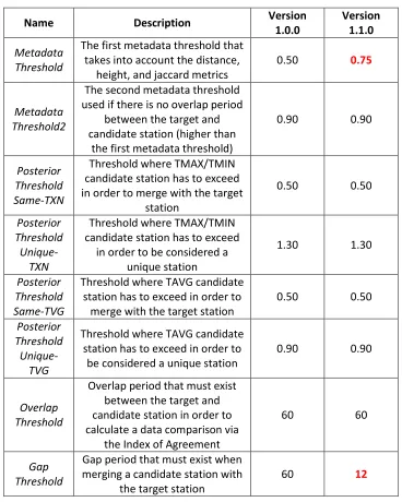
The merge algorithm, as described by Rennie et al. 2014, underwent no code changes. However, a couple of thresholds were modified in order to maximize the amount of data
the final recommended product would have (Table 2). The thresholds are defined in a
configuration file that is required for the program to run successfully.
The first step of the merge algorithm takes into account the metadata between a target
and candidate station, including the stations latitude, longitude, elevation and name. A
quasi-probabilistic comparison is made and the result is a metadata metric between 0
and 1. In version 1.0.0, this metric needed to pass a threshold of 0.50 in order to be
considered for merging. Analysis showed that too many stations were being pulled
through and forcing merges between stations that shouldn’t have. As a result, a stricter
threshold of 0.75 was applied, in order to avoid this issue.
In addition, once a candidate station is chosen to merge with a candidate station, it
needs to fill in a gap of at least 60 months (5 years) in order to be added to the target
station. It was determined that this gap was too large, and target stations with short
gaps in its data were not being filled in by qualifying candidate stations. This gap
threshold has been reduced to 12 months as a result.
Similar to version 1.0.0, all decisions made were tested against an independent dataset
generated from hourly data for US stations available in the Integrated Surface Dataset
Page 4
4. Results
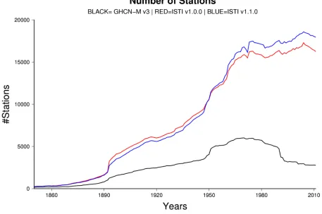
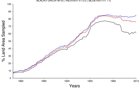
Version 1.1.0 of the recommended merge contains 35,932 stations (Figure 1), nearly
4,000 stations more than v1.0.0 (32,142). Figure 2 depicts that the addition of stations
reflect the most recent period, as there is relatively a 10% increase in the number of
stations since 1950. It should be noted that there is a drop in coverage prior to 1950
with the new version. However it is the author’s opinion that this was reflected by
removing crutem4 as one of the sources. Including this source had made candidate
stations unique, due to differences in its data as a result of the data providers bias
corrections. While the number of stations is lower during this time period for v1.1.0, it
should be noted that the number of gridboxes used in analysis (Figure 3) was either
equal, or slightly higher than v1.0.0.
Stage Three normally includes a merge recommended and endorsed by ISTI, along
5. References
Menne MJ, Durre I, Vose RS, Gleason BE, Houston TG. 2012. An Overview of the Global Historical Climatology Network-Daily Database. Journal of Atmospheric and Oceanic Technology29, 897-910, doi: 10.1175/JTECH-D-11-00103.1.
Rennie, J. J., Lawrimore, J. H., Gleason, B. E., Thorne, P. W., Morice, C. P., Menne, M. J., Williams, C. N., de Almeida, W. G., Christy, J.R., Flannery, M., Ishihara, M.,
Kamiguchi, K., Klein-Tank, A. M. G., Mhanda, A., Lister, D. H., Razuvaev, V., Renom, M., Rusticucci, M., Tandy, J., Worley, S. J., Venema, V., Angel, W., Brunet, M., Dattore, B., Diamond, H., Lazzara, M. A., Le Blancq, F., Luterbacher, J., Mächel, H., Revadekar, J., Vose, R. S. and Yin, X. (2014), The international surface temperature initiative global land surface databank: monthly temperature data release description and methods.
Geoscience Data Journal, 1: 75–102. doi: 10.1002/gdj3.8
Smith A, Lott N, Vose RS. 2011. The Integrated Surface Database: recent
Page 6
6. Tables
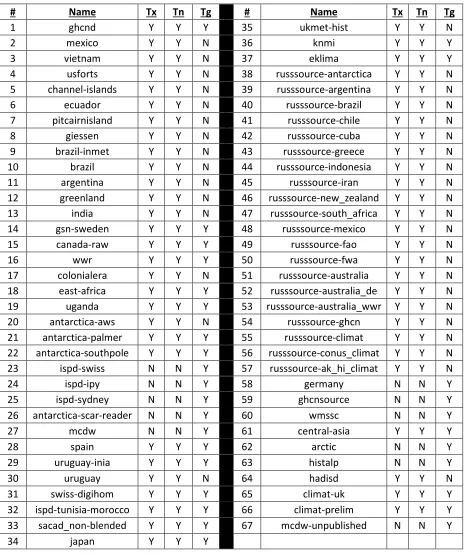
Table 1. Summary of Stage Two sources, in prioritized form, used for the recommended
version of the merge program, version 1.1.0.
# Name Tx Tn Tg # Name Tx Tn Tg
1 ghcnd Y Y Y 35 ukmet-hist Y Y N
2 mexico Y Y N 36 knmi Y Y Y
3 vietnam Y Y N 37 eklima Y Y Y
4 usforts Y Y N 38 russsource-antarctica Y Y N 5 channel-islands Y Y N 39 russsource-argentina Y Y N 6 ecuador Y Y N 40 russsource-brazil Y Y N 7 pitcairnisland Y Y N 41 russsource-chile Y Y N 8 giessen Y Y N 42 russsource-cuba Y Y N 9 brazil-inmet Y Y N 43 russsource-greece Y Y N 10 brazil Y Y N 44 russsource-indonesia Y Y N 11 argentina Y Y N 45 russsource-iran Y Y N 12 greenland Y Y N 46 russsource-new_zealand Y Y N 13 india Y Y N 47 russsource-south_africa Y Y N 14 gsn-sweden Y Y Y 48 russsource-mexico Y Y N 15 canada-raw Y Y Y 49 russsource-fao Y Y N
16 wwr Y Y Y 50 russsource-fwa Y Y N
17 colonialera Y Y N 51 russsource-australia Y Y N 18 east-africa Y Y Y 52 russsource-australia_de Y Y N 19 uganda Y Y Y 53 russsource-australia_wwr Y Y N 20 antarctica-aws Y Y N 54 russsource-ghcn Y Y N 21 antarctica-palmer Y Y Y 55 russsource-climat Y Y N 22 antarctica-southpole Y Y Y 56 russsource-conus_climat Y Y N 23 ispd-swiss N N Y 57 russsource-ak_hi_climat Y Y N
24 ispd-ipy N N Y 58 germany N N Y
25 ispd-sydney N N Y 59 ghcnsource N N Y 26 antarctica-scar-reader N N Y 60 wmssc N N Y
27 mcdw N N Y 61 central-asia Y Y Y
28 spain Y Y Y 62 arctic N N Y
29 uruguay-inia Y Y Y 63 histalp N N Y
30 uruguay Y Y N 64 hadisd Y Y N
31 swiss-digihom Y Y Y 65 climat-uk Y Y Y 32 ispd-tunisia-morocco Y Y Y 66 climat-prelim Y Y Y 33 sacad_non-blended Y Y Y 67 mcdw-unpublished N N Y
Table 2. List of user defined thresholds in the merge program (version 1.0.0 and version 1.1.0). Changes are noted in red. These thresholds can be altered in the configuration file. Note that the first metadata threshold must be less than the second.
Name Description Version 1.0.0 Version 1.1.0
Metadata Threshold
The first metadata threshold that takes into account the distance,
height, and jaccard metrics 0.50 0.75
Metadata Threshold2
The second metadata threshold used if there is no overlap period
between the target and candidate station (higher than
the first metadata threshold)
0.90 0.90
Posterior Threshold Same-TXN
Threshold where TMAX/TMIN candidate station has to exceed in order to merge with the target
station
0.50 0.50
Posterior Threshold
Unique-TXN
Threshold where TMAX/TMIN candidate station has to exceed
in order to be considered a unique station
1.30 1.30
Posterior Threshold Same-TVG
Threshold where TAVG candidate station has to exceed in order to
merge with the target station 0.50 0.50
Posterior Threshold
Unique-TVG
Threshold where TAVG candidate station has to exceed in order to
be considered a unique station 0.90 0.90
Overlap Threshold
Overlap period that must exist between the target and candidate station in order to calculate a data comparison via
the Index of Agreement
60 60
Gap Threshold
Gap period that must exist when merging a candidate station with
the target station 60 12
Table 3. Results of validation scheme for versions v1.0.0 and v1.1.0, using an
independent dataset.
Version # Stns # Merged # Unique # Withheld
v1.0.0 1952 1668 (85.45%) 5 (0.26%) 279 (14.29%)
Page 8
7. Figures
Figure 1. Location of all stations in the recommended Stage Three
Page 10
Figure 3. Percentage of global coverage with respect to 5 degree