University of New Orleans University of New Orleans
ScholarWorks@UNO
ScholarWorks@UNO
University of New Orleans Theses and
Dissertations Dissertations and Theses
Summer 8-2-2012
A Framework to Annotate the Uncertainty for Geospatial Data
A Framework to Annotate the Uncertainty for Geospatial Data
Zhao Yang
Follow this and additional works at: https://scholarworks.uno.edu/td
Part of the Software Engineering Commons
Recommended Citation Recommended Citation
Yang, Zhao, "A Framework to Annotate the Uncertainty for Geospatial Data" (2012). University of New Orleans Theses and Dissertations. 1528.
https://scholarworks.uno.edu/td/1528
This Thesis is protected by copyright and/or related rights. It has been brought to you by ScholarWorks@UNO with permission from the rights-holder(s). You are free to use this Thesis in any way that is permitted by the copyright and related rights legislation that applies to your use. For other uses you need to obtain permission from the rights-holder(s) directly, unless additional rights are indicated by a Creative Commons license in the record and/or on the work itself.
A Framework to Annotate the Uncertainty for Geospatial Data
A Thesis
Submitted to the Graduate Faculty of the University of New Orleans in partial fulfillment of the requirements for the degree of
Master of Science in
the Department of Computer Science
by
Zhao Yang
Northwestern Polytechnical University, China, 2001
ACKNOWLEDGEMENT
I would like to express my heartfelt gratitude to my major professor Dr. Mahdi
Abdelguefi for his belief in me and the support extended by him throughout my work. It
has been a wonderful experience to work under his guidance. Dr. Elias Ioup also gave me
help on my research.
I would like to thank Dr.Shengru Tu and Dr.Golden Richard III for being a part of my
thesis committee.
Table of Contents
ABSTRACT ... v
CHAPTER 1 INTRODUCTION ... 1
CHAPTER 2 BACKGROUND ... 4
2.1 Geographic information system ... 5
2.1.1 Geography Markup Language ... 5
2.1.2 GML application schema ... 7
2.1.3 GML Grid schema ... 8
2.1.4 Domain set definition ... 11
2.2 Overview of Uncertainty schema ... 13
2.3 OGC standards and OGC Web Services ... 15
2.4 GIS uncertainties ... 16
2.5 Previous work ... 18
CHAPTER 3 THE FRAMEWORK ... 20
3.1 Framework Overview ... 20
3.2 Framework Architecture ... 20
3.3 Framework Components ... 22
3.3.1 GML application schema ... 23
3.3.2 GML ... 24
3.3.3 Grids schema ... 25
3.3.4 Uncertainty Schema ... 26
3.3.5 Geoserver ... 29
3.3.6 Gaia ... 30
CHAPTER 4 FRAMEWORK IMPLEMENTATION ... 32
4.1 Uncertainty data loading process ... 32
4.2 Define the coverage schema... 33
4.3 Define the grid ... 36
4.4 Specify the distribution information ... 38
4.5 User defined distribution ... 41
4.6 Making data with user-defined distribution ... 43
4.7 Visualize data in Gaia... 46
CHAPTER 5 APPLICATIONS OF THE FRAMEWORK ... 50
5.1 Depth sounding error measurement ... 50
5.2 Advanced route planning ... 55
5.3 Circular error for shore line ... 65
CHAPTER 6 CONCLUSION AND FUTURE WORK ... 75
Reference ... 76
Table of Figures
Figure 2. 1 Sample Grid definition[3] ... 9
Figure 2. 2 RectifiedGrid definition format[3] ... 10
Figure 2. 3 RectifiedGrid Geometry[3] ... 10
Figure 2. 4 Sample RectifiedGrid definition[3] ... 11
Figure 2. 5 Sample AbstractCoverageType definition[3] ... 12
Figure 2. 6 Sample DomainSetType definition[3] ... 13
Figure 3. 1 Framework Architecture ... 21
Figure 3. 2 Framework Components Diagram ... 22
Figure 3. 3 Import GML application schema[3] ... 23
Figure 3. 4 GML data file format ... 25
Figure 3. 5 XML schema of Confidence Interval [4] ... 27
Figure 3. 6 XML example of Confidence Interval [4] ... 28
Figure 3. 7 XML schema of Binomial Distribution [4] ... 28
Figure 3. 8 XML example of Binomial Distribution [4] ... 29
Figure 4. 1 GML data file format ... 33
Figure 4. 2 GML AbstractCoverageType definition[3] ... 34
Figure 4. 3 GML DiscreteCoverageType definition[3] ... 35
Figure 4. 4 UncertaintyCoverage element definition in application schema ... 35
Figure 4. 5 Schema information in the GML data file ... 36
Figure 4. 6 Example instance of agml:RectifiedGrid[3] ... 37
Figure 4. 7 Example instance of a gml:RectifiedGrid ... 38
Figure 4. 8 Distribution type definition in Uncertainty schema ... 40
Figure 4. 9 Uncertainty data in GML using uncertainty schema ... 41
Figure 4. 10 XML schema for quantile in UncertML [4] ... 42
Figure 4. 11 Application schema definition for CEP ... 42
Figure 4. 12 CEP usage sample ... 43
Figure 4. 13 Sample application schema for Louisiana highway case ... 45
Figure 4. 14 Sample GML for Louisiana highway case ... 46
Figure 4. 15 Load GML data file to Gaia ... 47
Figure 4. 16 Grids information showed in Gaia ... 48
Figure 4. 17 Uncertainty information showed in Gaia ... 49
Figure 5. 1 Schema for depth sounding with error notations ... 51
Figure 5. 2 Hierarchical nature of XML ... 52
Figure 5. 3 Sample application schema for depth sounding case ... 53
Figure 5. 5 The advanced route planning algorithm ... 56
Figure 5. 6 Data source and error for route planning ... 57
Figure 5. 7 Different data source with different standard deviation ... 58
Figure 5. 8 Sample application schema for Louisiana roads case ... 61
Figure 5. 9 Sample GML for Louisiana highway case ... 63
Figure 5. 10 Sample GML for tl_roads case ... 65
Figure 5. 11 Map with 1:250,000 scale level ... 67
Figure 5. 12 Map with 1:12,000,000 scale level ... 67
Figure 5. 13 Sample application schema for Shore Line case ... 69
Figure 5. 14 Sample GML for 1:250,000 map scale level ... 71
Figure 5. 15 Sample GML for 1:12,000,000 map scale level ... 72
Figure 5. 16 Map with circular error of 500m ... 73
ABSTRACT
We have developed a new approach to annotate the uncertainty information of geospatial
data. This framework is composed of a geospatial platform and the data with uncertainty.
The framework supports geospatial sources such as Geography Markup Language (GML)
with uncertainty information. The purpose of this framework is to integrate the
uncertainty information of data from the application users and thereby ease the
development of processing uncertainty information of geospatial data. Having well
organized data and using this framework, the end-users can store the uncertainty
information on the current geospatial data structure. For example, a GIS user can share
the error information for environmental and geospatial data to others. We also report on
the enhanced geographic information system functionality.
Keywords
Geospatial Information System, Geospatial Markup Language, Uncertainty,
CHAPTER 1 INTRODUCTION
The Geography Markup Language (GML) is the XML grammar defined by the Open
Geospatial Consortium (OGC) to express geographical features. GML serves as a
modeling language for geographic systems as well as an open interchange format for
geographic transactions on the Internet [1]. However there is no general language format
for sharing error information of geospatial data. The ability to provide a general language
for sharing uncertainty information for environmental and geospatial data is a
requirement for many Geospatial Information System (GIS) users [2].
Current techniques for transmitting uncertainty information are overly specialized or
ad hoc. The techniques are not supported by data sharing standards. They are incapable of
reflecting the origins of error in data sets. Data sharing and automation are also features
required by GIS users. GIS users are expected to use unfamiliar datasets. The implicit
error information is insufficient. The automated sharing is limited without error
information. In the field of ocean and acoustic modeling, there is still limited use of
scientific data without error measures. The new models are incorporating statistical
distributions as inputs and as outputs.
The goal of the framework is to create a language for marking data with error information.
The language is an XML schema that formally defines the vocabulary and syntax for
indicating error estimates. The following factors need be considered. First the error
error distributions, for instance, continuous distribution or discrete distribution,
systematic distribution or random distribution, multi-variable distribution or
non-independent distribution. Second, the language must support user-defined error
analysis. The automatic error calculations for complex processes are not possible. Lastly,
the error information can be cumulative. The language must support complete traceability
of error terms from end-to-end.
In this project, we have developed a framework that helps users process uncertainty
information of Geospatial data. This framework is composed of GML application schema
[3], Uncertainty schema, GML Grids schema, Geoserver and Gaia software that allow the
uncertainty information to be visualized by software. With a well-defined GML
application schema and this framework, the uncertainty information is easy to access by
Web services. The whole framework provides a general solution for marking, propagation
and transmission of error information for Environmental and Geospatial data.
Compared to UncertML [4], our framework supports GML instead of XML. It is
convenient to transform current GML data to the format of GML with error information.
The framework is being constructed on an open source software platform. However, the
framework does not require comprehensive programming skills; the uncertainty
information is easy to access and visualized.
This thesis is organized as follows: Chapter 2 deals with the background knowledge of
the project. The concepts and definitions of Geography Information System, Geospatial
framework introduction; the architecture and advantages of the framework have been
discussed. The design of various components of the framework has been presented in
detail. Chapter 4 describes the implementation details of the framework. The
implementation of all the framework components will be discussed in detail. Chapter 5
presents examples on how to use the framework to build uncertainty information based
GML schema. Three such applications are presented. Chapter 6 discusses the conclusions
CHAPTER 2 BACKGROUND
The Geography Markup Language (GML) is the XML grammar defined by the Open
Geospatial Consortium (OGC) to express geographical features. In many circumstances,
user have a requirement to provide a general language for sharing error information for
environmental and geospatial data. Previous research automates the use of existing
standards for data sharing.
• GML: Geospatial Markup Language
• KML: Keyhole Markup Language (Google Earth)
• WFS: Web Feature Service
• WCS: Web Coverage Service
• WPS: Web Processing Service
Data providers are mandated to use these standards. Standards all support sophisticated
geospatial and environmental constructs by default such as datums, projections, topology,
grids, etc. However none of these standards support uncertainty information. To
accomplish this we need to build a framework into the GML standard. This can be done
2.1 Geographic information system
A geographic information system is a system designed to capture, store, manipulate,
analyze, manage, and present all types of geographical data. The acronym GIS is
sometimes used for geographical information science or geospatial information studies to
refer to the academic discipline or career of working with geographic information
systems. In the simplest terms, GIS is the merging of cartography, statistical analysis, and
database technology.
A GIS can be thought of as a system—it digitally creates and "manipulates" spatial areas
that may be jurisdictional, purpose, or application-oriented. Generally, a GIS is
custom-designed for an organization. What goes beyond a GIS is a spatial data
infrastructure (SDI), a concept that has no such restrictive boundaries. In a general sense,
the term describes any information system that integrates stores, edits, analyzes, shares,
and displays geographic information for informing decision making. GIS applications are
tools that allow users to create interactive queries (user-created searches), analyze spatial
information, edit data in maps, and present the results of all these operations [2].
2.1.1 Geography Markup Language
Geography Markup Language is an XML grammar written in XML Schema for use in the
description of application schemas as well as the transport and storage of geographic
the world are drawn from the ISO 19100 series of International Standards and the
OpenGIS Abstract Specification.
Geographic features with geometry are those with properties that may be
geometry-valued. A feature collection is a collection of features that may itself be
regarded as a feature; as a consequence a feature collection has a feature type and thus
may have distinct properties of its own, in addition to the features it contains.
Predefined types of geographic feature in GML include coverage and simple observations.
We will use these types in our framework to define uncertainty information.
Coverage is a subtype of feature that has a coverage function with a spatiotemporal
domain and a value set range of homogeneous 1- to n-dimensional tuples. Coverage may
represent one feature or a collection of features ― to model and make visible spatial
relationships between, and the spatial distribution of, Earth phenomena and a
coverage ―acts as a function to return values from its range for any direct position within
its spatiotemporal domain (ISO 19123). An observation is considered to be a GML
feature with a time at which the observation took place, and with a value for the
observation.
A reference system provides a scale of measurement for assigning values to a position,
time or other descriptive quantity or quality.
A coordinate reference system consists of a set of coordinate system axes that is related to
the Earth through a datum that defines the size and shape of the Earth.
temporal length or duration.
A reference system dictionary provides definitions of reference systems used in spatial or
temporal geometries [3].
2.1.2 GML application schema
GML application schema has been used to define the data structure of our framework.
Designers of GML application schemas may extend or restrict the types defined in the
GML schema to define appropriate types for an application domain. Non-abstract
elements, attributes and types from the GML schema may be used directly in an
application schema, if no changes are required.
Following ISO 19109, the feature types of an application or application domain are
specified in an application schema. A GML application schema shall be specified in XML
Schema and import the GML schema. It may be constructed in one of two different ways:
• By adhering to the rules for GML application schemas specified for creating a
GML application schema directly in XML Schema.
• By adhering to the rules specified in ISO 19109 for application schemas in UML,
and conforming to both the constraints on such schemas and the rules for mapping
them to GML application schemas. The mapping from an ISO 19109 conformant
Application Schema in UML to the corresponding GML application schema is
GML application schemas and ISO 19118.
Both ways are valid approaches to construct GML application schemas. All application
schemas shall be modeled in accordance with the General Feature Model specified in ISO
19109. Within the ISO 19100 series, UML is the preferred language to describe
conceptual schemas.
GML application schemas conformant with this International Standard shall use all of the
applicable GML schema components, either directly or by specialization, and are valid in
accordance with the rules for XML Schema [3]. The detail of application schema will be
represented in following chapter.
2.1.3 GML Grid schema
In this framework we use GML Grid to display sets of uncertainty information. This
clause provides grid geometries that are used in the description of gridded coverage and
other applications.
In GML two grid structures are defined, namely gml:Grid and gml:RectifiedGrid.
gml:Grid implements ISO 19123 CV_Grid (see D.2.11 and ISO 19123:2005, 8.3) and is
defined as follows:
<complexType name="GridType"> <complexContent>
<extension base="gml:AbstractGeometryType"> <sequence>
<element name="limits" type="gml:GridLimitsType"/>
<choice>
<element name="axisLabels" type="gml:NCNameList"/>
<element name="axisName" type="string" maxOccurs="unbounded"/> </choice>
</sequence>
<attribute name="dimension" type="positiveInteger"
use="required"/>
</extension> </complexContent>
</complexType>
Figure 2. 1 Sample Grid definition[3]
The gml:Grid implicitly defines an unrectified grid, which is a network composed of two
or more sets of curves in which the members of each set intersect the members of the
other sets in an algorithmic way. The region of interest within the grid is given in terms of
its gml:limits, being the grid coordinates of diagonally opposed corners of a rectangular
region. gml:axisLabels is provided with a list of labels of the axes of the grid
(gml:axisName has been deprecated). gml:dimension specifies the dimension of the grid.
A rectified grid is a grid for which there is an affine transformation between the grid
coordinates and the coordinates of an external coordinate reference system. It is defined
by specifying the position (in some geometric space) of the grid ―origin and of the
vectors that specify the post locations [3].
gml:RectifiedGrid implements ISO 19123 CV_RectifiedGrid (see D.2.11 and ISO
19123:2005, 8.9) and is declared as follows:
<element name="RectifiedGrid" type="gml:RectifiedGridType" substitutionGroup="gml:Grid"/>
<complexType name="RectifiedGridType"> <complexContent>
<extension base="gml:GridType"> <sequence>
<element name="origin" type="gml:PointPropertyType"/> <element name="offsetVector" type="gml:VectorType"
maxOccurs="unbounded"/>
</sequence> </extension>
</complexContent>
</complexType>
Figure 2. 2 RectifiedGrid definition format[3]
Note that the grid limits (post indexes) and axis name properties are inherited from
gml:GridType and that gml:RectifiedGrid adds a gml:origin property (contains or
references a gml:Point) and a list of gml:offsetVector properties (specified using
gml:VectorType as its data type as described in 10.1.4.5).
Key
O origin p1,p2 offset vectors
EXAMPLE 2 An example instance of a gml:RectifiedGrid is as follows:
<gml:RectifiedGrid dimension="2">
<gml:limits>
<gml:GridEnvelope>
<gml:low>1 1</gml:low>
<gml:high>4 4</gml:high> </gml:GridEnvelope>
</gml:limits>
<gml:axisLabels>u v</gml:axisLabels>
<gml:origin>
<gml:Point gml:id="palindrome"
srsName="urn:x-ogc:def:crs:EPSG:6.6:4326"> <gml:pos>3 1.1</gml:pos>
</gml:Point> </gml:origin>
<gml:offsetVector
srsName="urn:x-ogc:def:crs:EPSG:6.6:4329"> -0.2 1.25
</gml:offsetVector> <gml:offsetVector
srsName="urn:x-ogc:def:crs:EPSG:6.6:4329"> 1.3 0.2
</gml:offsetVector>
</gml:RectifiedGrid>
Figure 2. 4 Sample RectifiedGrid definition[3]
The detail of implementation will be discussed in following chapter.
2.1.4 Domain set definition
The base type for coverages is gml:AbstractCoverageType, defined in the schema as
<complexType name="AbstractCoverageType" abstract="true">
<complexContent>
<extension base="gml:AbstractFeatureType">
<sequence>
<element ref="gml:domainSet"/>
<element ref="gml:rangeSet"/> </sequence>
</extension>
</complexContent> </complexType>
Figure 2. 5 Sample AbstractCoverageType definition[3]
The basic elements of a coverage can be seen in this content model: the coverage contains
gml:domainSet and gml:rangeSet properties. The gml:domainSet property describes the
domain of the coverage and the gml:rangeSet property describes the range of the
coverage.
The abstract element gml:AbstractCoverage implements ISO 19123 CV_Coverage (see
D.2.11 and ISO 19123:2005, 5.3) and is declared as follows:
<element name="AbstractCoverage" type="gml:AbstractCoverageType" abstract="true"
substitutionGroup="gml:AbstractFeature"/>
This element serves as the head of a substitution group which may contain any coverage
whose type is derived from gml:AbstractCoverageType. It may act as a variable in the
definition of content models where it is required to permit any coverage to be valid.
The gml:domainSet property element describes the spatio-temporal region of interest,
within which the coverage is defined. Its content model is given by gml:DomainSetType
<element name="domainSet" type="gml:DomainSetType"/>
<complexType name="DomainSetType">
<sequence minOccurs="0"> <choice>
<element ref="gml:AbstractGeometry"/> <element ref="gml:AbstractTimeObject"/>
</choice>
</sequence>
<attributeGroup ref="gml:OwnershipAttributeGroup"/>
<attributeGroup ref="gml:AssociationAttributeGroup"/>
</complexType>
Figure 2. 6 Sample DomainSetType definition[3]
The value of the domain is thus a choice between a gml:AbstractGeometry and a
gml:AbstractTimeObject. In the instance these abstract elements will normally be
substituted by a geometry complex or temporal complex, to represent spatial coverage
and time-series, respectively.
The presence of the gml:AssociationAttributeGroup means that domainSet follows the
usual GML property model and may use the xlink:href attribute to point to the domain, as
an alternative to describing the domain inline. Ownership semantics may be provided
using the gml:OwnershipAttributeGroup [3]. The detail of implementation will be
discussed in following chapter.
In this framework we use Uncertainty schema to define the data structure of error
information. UncertML is a conceptual model and XML encoding designed for
encapsulating probabilistic uncertainties. UncertML is a conceptual model, with
accompanying XML schema that may be used to quantify and exchange complex
uncertainties in data. The interoperable model can be used to describe uncertainty in a
variety of ways including:
• Samples
• Statistics including mean, variance, standard deviation and quantile
• Probability distributions including marginal and joint distributions and mixture
models
Utilizing the XML schema provides an interoperable framework for exchanging
uncertainties. This allows uncertainty to be propagated through processing chains.
Uncertainty can be quantified in several different ways within UncertML. There are
several methods for describing uncertainty including the common elements.
In some situation a user may provide a sample of the data which allows the uncertainties
to be described implicitly. Unfortunately, a sufficiently large sample of data is required
for calculating the uncertainties, introducing the issue of encapsulating large amounts of
data efficiently.
There is an extensive range of options available in UncertML for describing 'summary
statistics'. Such statistics are used to provide a summary of a variable ranging from
standard deviation, variance etc). While certain statistics do not provide any information
about uncertainty they are often used in conjunction with other statistics to provide a
concise but detailed summary [4]. The detail of implementation will be discussed in
following chapter.
2.3 OGC standards and OGC Web Services
OGC(R) standards are technical documents that detail interfaces or encodings. Software
developers use these documents to build open interfaces and encodings into their
products and services. These standards are the main "products" of the Open Geospatial
Consortium and have been developed by the membership to address specific
interoperability challenges.
OGC standards and supporting documents are available to the public at no cost. OGC
Web Services (OWS) are OGC standards created for use in World Wide Web applications.
Any Schemas (xsd, xslt, etc) that support an approved (that is, approved by the OGC
membership) OGC standard can be found in the official OGC Schema Repository [5].
The generality of W3C Services are a problem when users desire a standard set of
functionality from Web services. In the geospatial domain, there are several common
classes of services. If these services each had standardized functionality, they would
become easier to integrate into systems and thus, more useful. The Open Geospatial
standardized interface and standardized functionality. By standardizing functionality, the
clients for these services may be generic. Unlike for W3C Services, there is no need to
create a client for each specific service. As long as a service follows the OGC standard,
the client who also follows the standard will work with it.
The OGC has created a large number of geospatial Web service standards. However, three
are the most commonly used. The Web Mapping Service (WMS) is used to transfer
georeferenced images from the server to the client. The Web Feature Service (WFS) is
used to transfer vector data (points, lines, polygons, etc.) encoded using Geography
Markup Language (GML), a geospatial specific XML subset. The Web Coverage Service
(WCS) is used to transfer geospatial multidimensional raster data. As opposed to the
WMS standard, the focus of WCS is on data encoded in formats not supported by Web
browsers. WCS originally only supported grid data formats such as GeoTIFF or NetCDF;
however, current versions of the standard allow any encoding format for data transfers [6].
The detail of implementation will be discussed in following chapter.
2.4 GIS uncertainties
GIS accuracy depends upon source data, and how it is encoded to be data referenced.
Land surveyors have been able to provide a high level of positional accuracy utilizing the
GPS derived positions. the high-resolution digital terrain and aerial imagery, the powerful
serve society on a grand scale, but nevertheless there are other source data that has an
impact on the overall GIS accuracy like: paper maps that are not found to be very suitable
to achieve the desired accuracy since the aging of maps affects their dimensional stability.
In developing a digital topographic data base for a GIS, topographical maps are the main
source of data. Aerial photography and satellite images are extra sources for collecting
data and identifying attributes which can be mapped in layers over a location facsimile of
scale. The scale of a map and geographical rendering area representation type are very
important aspects since the information content depends mainly on the scale set and
resulting locatability of the map's representations. In order to digitize a map, the map has
to be checked within theoretical dimensions, and then scanned into a raster format, and
resulting raster data has to be given a theoretical dimension by a rubber sheeting/warping
technology process.
A quantitative analysis of maps brings accuracy issues into focus. The electronic and
other equipment used to make measurements for GIS is far more precise than the
machines of conventional map analysis. All geographical data are inherently inaccurate,
and these inaccuracies will propagate through GIS operations in ways that are difficult to
predict.
A GIS can also convert existing digital information, which may not yet be in map form,
into forms it can recognize, employ for its data analysis processes, and use in forming
mapping output. For example, digital satellite images generated through remote sensing
covers on land locations. Another fairly recently developed resource for naming GIS
location objects is the Getty Thesaurus of Geographic Names (GTGN), which is a
structured vocabulary containing about 1,000,000 names and other information about
places. Likewise, researched census or hydrological tabular data can be displayed in
map-like form, serving as layers of thematic information for forming a GIS map [2].
2.5 Previous work
For processing uncertainty information, there must be a framework to organize and parse
the uncertainty data format. The solutions used in existing research are to create XML
schema descriptions.
In the previous INTAMAP approach of Aston University of UK, they have developed a
framework to support information-rich transfer of complex and uncertain predictions.
They developed schema to represent probabilistic results in a GML3.1 (object-property)
style. The system will also offer more easily accessible Web Map Service and Web
Coverage Service interfaces to allow users to access the system at the level of complexity
they require for their specific application. Such a system will offer a very valuable
contribution to the next generation of Environmental Information Systems in the context
of real time mapping for monitoring and security, particularly for systems that employ
service oriented architecture [7].
provides a framework for describing uncertainty as it propagates through many
applications, including online risk management chains. This uncertainty description
ranges from simple summary statistics (e.g., mean and variance) to complex
representations such as parametric, multivariate distributions at each point of a regular
grid. The philosophy adopted in UncertML is that all data values are inherently uncertain,
(i.e., they are random variables, rather than values with defined quality metadata) [8].
The paper “Visualizing Geospatial Information Uncertainty: What We Know and What
We Need to Know” talked about identifying seven key research challenges in visualizing
information uncertainty, particularly as it applies to decision making and analysis. An
important part of a broad strategy is to enable analysts, decision makers, and others to
cope with uncertain information. A wide variety of strategies has been proposed for
uncertainty visualization, and there is a growing body of empirical research that is
providing insights concerning which method share effective in different use contexts and
for which types of tasks [9]. Still, the author has only scratched the surface of the
problem. For example, we cannot yet say definitively whether decisions are better if
uncertainty is visualized or suppressed, or under what conditions they are better; nor do
we understand the impact of uncertainty visualization on the process of analysis or
CHAPTER 3 THE FRAMEWORK
3.1 Framework Overview
There are no standards supporting uncertainties of geospatial data processing. The data
providers are mandated to use the existing OGC standards. Current standards all support
sophisticated geospatial and environmental constructs by default, for example, Datums,
Projections, Topology, Grids, etc. However none of these standards support uncertainty
information. In this project, we have developed a framework that helps the users who
need integrate the uncertainty information to the geospatial data. The framework will
provide the following functions:
• Formal Standard as an XML Schema that defines the vocabulary and syntax for
indicating error estimates.
• Tier based classification system for qualities of certainty reporting.
• Guidance for integration of tiered framework into existing processes.
• Guidance and tools for discretization of tiered certainty information.
• Best practice recommendations and tools for certainty provenance analysis.
3.2 Framework Architecture
The framework design has been based on Geospatial Markup Language and GML
application schema. The structure of uncertainty information is defined as element of
parse the uncertainty information in GML data. The GML data file is readable by
geospatial software such as Gaia.
The flow control of the frame work is simple: The uncertainty information is defined as
GML application schema. The GML files import that application schema. The coordinate
information also is defined as a rectified grid object. The uncertainty information is
defined as <gml:rangeSet> object of the GML grid. Each POI (Points of Interest) has its
own uncertainty information. The framework is flexible and scalable for various types of
uncertainty information. It is easy to customize and extend the framework for other user
defined data set.
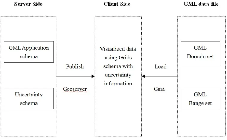
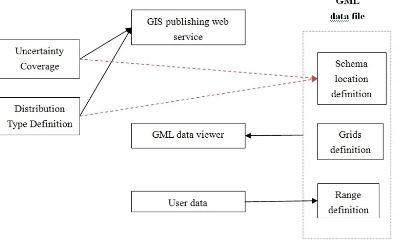
3.3 Framework Components
The framework consists of several major components as shown in Figure 3.2 in which the
component GML application schema represents the “Schema”. The GML data file
component represents the “GML”. The distribution type definition schema represents the
“uncertainty Schema” to import. The application schema and uncertainty schema are
specified in the head of GML data file. The gird definition of GML data file specifies the
GML grid definition. The user data will be loaded into range definition of GML data file.
The components are discussed in the following sub sections.
3.3.1 GML application schema
A schema is an abstract collection of metadata, consisting of a set of schema components:
chiefly element and attribute declarations and complex and simple type definitions. These
components are usually created by processing a collection of schema documents, which
contain the source language definitions of these components. In popular usage, however,
a schema document is often referred to as a schema. The application schema has been
written to conform to the GML standard. The application schema must import several
GML namespaces.
A GML application schema shall import the full GML schema. It may identify GML
profiles that include all of the components from GML that it directly or indirectly uses to
define its vocabulary as specified.
The required import of the GML schema components may be provided indirectly via the
import of another schema in the namespace of GML that includes the required GML
schema documents.
EXAMPLE 1 The import of gml.xsd from Annex C would satisfy any of these
schema import requirements.
<import namespace="http://www.opengis.net/gml/3.2" schemaLocation="../gml.xsd"/>
Figure 3. 3 Import GML application schema[3]
The <import> element specifies that the components described in the imported GML
http://www.opengis.net/gml/3.2. This namespace identifier shall match the target
namespace specified in the schema being imported in order to ensure XML Schema
validity.
The path (schemaLocation) to the imported GML schema document shall be provided
and may point to a local copy of the document, or may point to a URI reference to a copy
of the schema document in some remote repository [3].
In order to create a GML application schema user also need import the Uncertainty
schema as namespace. It consists of an XSD element for type of Grids, which contain the
<gml:CoverageType> type. The structure of application schema is flexible and easy to
extend for more types of features. Users can define new type based on current sample
format. Therefore, user can organize his data by organizing the sequence of the XSD
element. Conforming to the GML, various methods have been defined in the GML
application schema for parsing the internal structures of GML files.
3.3.2 GML
The GML file contains the uncertainty information appended at the current geospatial
information. Designers of GML application schemas may extend or restrict the types
defined in the GML schema to define appropriate types for an application domain.
Non-abstract elements, attributes and types from the GML schema may be used directly
contains two different parts: Grid definition and Range definition. The Grid definition is
used to define positions of grid points. The Range definition is used to define the values
and the uncertainty information of the grid points.
We use EPSG:6.6:4326 as our coordinates system. User should specify the application
schema to define the structure of this GML file.
Figure 3. 4 GML data file format
3.3.3 Grids schema
A grid is simply a two-dimensional array. A grid has an integer width and height. The
structure allows you to set and retrieve the value of cells in the grid by giving the index of
it (which starts with 0 in both the x- and the y-direction). We can set the value in regions,
is useful to represent e.g. an acoustic field. Even though all functionality can also be
achieved using two-dimensional arrays, the operations on regions are a lot faster. In the
current case the coordinates of the POIs are continuous. So a Grid is an easy way to
visualize the data and uncertainty information. For the correctness of the data, users
should specify the appropriate value of the following parameters: coordinate system,
<gml:Envelope>, <gml:asisLables>, <gml:Origin>, <gml:offsetVector>.
3.3.4 Uncertainty Schema
UncertML is a conceptual model, realized as an XML schema, that allows uncertainty to
be quantified in a variety of ways i.e. realizations, statistics and probability distributions.
UncertML is based upon a soft-typed XML schema design that provides a generic
framework from which any statistic or distribution may be created. Making extensive use
of Geography Markup Language (GML) dictionaries, UncertML provides a collection of
definitions for common uncertainty types. Containing both written descriptions and
mathematical functions, encoded as MathML, the definitions within these dictionaries
provide a robust mechanism for defining any statistic or distribution and can be easily
extended. Universal Resource Identifiers (URIs) are used to introduce semantics to the
soft-typed elements by linking to these dictionary definitions [10].
UncertML is divided into three distinct packages. Each package is tailored toward
or probability distributions. In this framework, we only use distribution types. The
Gaussian distribution is the most common distribution in this case.
Here is an example about “Confidence Interval” of UncertML. Confidence Interval is a
concept to describe statistics information in UncertML.
<!-- Element -->
<xs:element name="ConfidenceInterval" substitutionGroup="un:AbstractSummaryStatistic">
<xs:complexType>
<xs:complexContent>
<xs:extension base="un:ConfidenceIntervalType"/>
</xs:complexContent>
</xs:complexType>
</xs:element>
<!-- Complex type -->
<xs:complexType name="ConfidenceIntervalType">
<xs:complexContent>
<xs:extension base="un:AbstractSummaryStatisticType">
<xs:sequence>
<xs:element name="lower" type="un:QuantileType"/>
<xs:element name="upper" type="un:QuantileType"/>
</xs:sequence>
</xs:extension>
</xs:complexContent>
</xs:complexType>
Figure 3. 5 XML schema of Confidence Interval [4]
<!-- Single value -->
<un:ConfidenceInterval xmlns:un="http://www.uncertml.org/2.0">
<un:lower level="0.05">
<un:values>3.14</un:values>
</un:lower>
<un:upper level="0.95">
<un:values>6.28</un:values>
</un:upper>
</un:ConfidenceInterval>
<!-- Multiple values -->
<un:ConfidenceInterval xmlns:un="http://www.uncertml.org/2.0">
<un:lower level="0.05">
<un:values>3.14 6.28 9.42</un:values>
</un:lower>
<un:upper level="0.95">
<un:values>6.28 12.57 18.85</un:values>
</un:upper>
</un:ConfidenceInterval>
Figure 3. 6 XML example of Confidence Interval [4]
Here is an example about “Binomial Distribution” of UncertML. Binomial Distribution is
a concept to describe distribution information in UncertML.
<!-- Element -->
<xs:element name="BinomialDistribution" substitutionGroup="un:AbstractDistribution">
<xs:complexType>
<xs:complexContent>
<xs:extension base="un:BinomialDistributionType"/>
</xs:complexContent>
</xs:complexType>
</xs:element>
<!-- Complex type -->
<xs:complexType name="BinomialDistributionType">
<xs:complexContent>
<xs:extension base="un:AbstractDistributionType">
<xs:sequence>
<xs:element name="numberOfTrials" type="un:NaturalNumbersType"/>
<xs:element name="probabilityOfSuccess" type="un:ProbabilityValuesType"/>
</xs:sequence>
</xs:extension>
</xs:complexContent>
</xs:complexType>
<!-- Single value -->
<BinomialDistribution>
<numberOfTrials>10</numberOfTrials>
<probabilityOfSuccess>0.5</probabilityOfSuccess>
</BinomialDistribution>
<!-- Multiple value -->
<BinomialDistribution>
<numberOfTrials>10 10 10</numberOfTrials>
<probabilityOfSuccess>0.5 0.5 0.5</probabilityOfSuccess>
</BinomialDistribution>
Figure 3. 8 XML example of Binomial Distribution [4]
3.3.5 Geoserver
GeoServer is an open source software server written in Java that allows users to share and
edit geospatial data. Designed for interoperability, it publishes data from any major
spatial data source using open standards. Being a community-driven project, GeoServer is
developed, tested, and supported by a diverse group of individuals and organizations
from around the world.
GeoServer is the reference implementation of the Open Geospatial Consortium (OGC)
Web Feature Service (WFS) and Web Coverage Service (WCS) standards, as well as a
high performance certified compliant Web Map Service (WMS). GeoServer forms a core
component of the Geospatial Web.
GeoServer allows you to display your spatial information to the world. Implementing the
formats. OpenLayers, a free mapping library, is integrated into GeoServer, making map
generation quick and easy. GeoServer is built on Geotools, an open source Java GIS
toolkit.
GeoServer can display data on any of the popular mapping applications such as Google
Maps, Google Earth, Yahoo Maps, and Microsoft Virtual Earth. In addition, GeoServer
can connect with traditional GIS architectures such as ESRI ArcGIS [11].
The primary purpose of the Geoserver in this framework is to publish the GML
application schema and Uncertainty schema on web. That make the schema is accessible
for the GML file. The GML file should use that GML application schema and
Uncertainty schema to parse the GML data.
3.3.6 Gaia
Gaia is a platform designed for advanced geospatial network and SDI needs. The primary
purpose of the Geoserver in this framework is to publish the GML application schema
and Uncertainty schema on the web. That make the schema accessible for the GML file.
The GML file should use that GML application schema and Uncertainty schema to parse
the GML data [12].
The Gaia software has the ability to visualize the GML data. The GML file should be
The uncertainty information is marked with POI. That information is visualized and easy
CHAPTER 4 FRAMEWORK IMPLEMENTATION
The Framework provides a general solution for marking, propagation and transmission of
error information for Environmental and Geospatial data.
The Framework supports storing and processing uncertainty information of geospatial
data with the four capabilities listed below:
1. Create methods for reporting uncertainty associated with geospatial and
environmental data
2. Establish data provenance procedures for traceability of the origins of uncertainty
3. Establish standard procedures for discretization of distributions
4. Use example studies to test and validate the framework
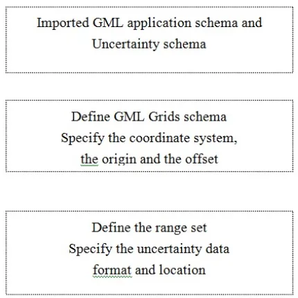
4.1 Uncertainty data loading process
This function is implemented in the GML application schema and GML data. At first, the
user should write a specific application schema to define the GML coverage type. In the
GML file, user should import this application schema and the uncertainty schema. User
should specify the distribution type of the data. Then the data will be stored as
<gml:rangeSet>. So the uncertainty information will automatically parsed by the GML
file reader.
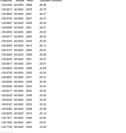
Figure 4.1 shows the raw data format. The uncertainty data contains the coordinates
Longitude latitude Mean Standard Deviation
-130.0000 49.0000 2698 26.98
-129.9917 49.0000 2678 26.78
-129.9833 49.0000 2657 26.57
-129.9750 49.0000 2637 26.37
-129.9667 49.0000 2639 26.39
-129.9583 49.0000 2651 26.51
-129.9500 49.0000 2650 26.50
-129.9417 49.0000 2650 26.50
-129.9333 49.0000 2635 26.35
-129.9250 49.0000 2613 26.13
-129.9167 49.0000 2603 26.03
-129.9083 49.0000 2599 25.99
-129.9000 49.0000 2591 25.91
-129.8917 49.0000 2581 25.81
-129.8833 49.0000 2569 25.69
-129.8750 49.0000 2535 25.35
-129.8667 49.0000 2547 25.47
-129.8583 49.0000 2539 25.39
-129.8500 49.0000 2544 25.44
-129.8417 49.0000 2542 25.42
-129.8333 49.0000 2548 25.48
-129.8250 49.0000 2540 25.40
-129.8167 49.0000 2533 25.33
-129.8083 49.0000 2528 25.28
-129.8000 49.0000 2519 25.19
-129.7917 49.0000 2490 24.90
-129.7833 49.0000 2481 24.81
-129.7750 49.0000 2458 24.58
… … … …
Figure 4. 1 GML data file format
From this sample data, we get the data boundary from [-130.0000, 49.0000] to
[-129.0000, 50.0000]. The origin point is [-130.0000, 49.0000]. The offset vectors in
this raw data are [0.083, 0],[0, 0.083].
The base type for coverages is gml:AbstractCoverageType, defined in the schema as follows:
<complexType name="AbstractCoverageType" abstract="true">
<complexContent>
<extension base="gml:AbstractFeatureType">
<sequence>
<element ref="gml:domainSet"/>
<element ref="gml:rangeSet"/>
</sequence>
</extension>
</complexContent>
</complexType>
Figure 4. 2 GML AbstractCoverageType definition[3]
The basic elements of a coverage can be seen in this content model: the coverage contains
gml:domainSet and gml:rangeSet properties. The gml:domainSet property describes the
domain of the coverage and the gml:rangeSet property describes the range of the
coverage.
A discrete coverage consists of a domain set, range set and optionally a coverage function.
The domain set consists of either spatial or temporal geometry objects, finite in number.
The range set is comprised of a finite number of attribute values each of which is
associated to every direct position within any single spatiotemporal object in the domain.
In other words, the range values are constant on each spatiotemporal object in the domain.
This coverage function maps each element from the coverage domain to an element in its
range. This definition conforms to ISO 19123. The base type for discrete coverage is
<complexType name="DiscreteCoverageType"> <complexContent>
<extension base="gml:AbstractCoverageType">
<sequence>
<element ref="gml:coverageFunction" minOccurs="0"/>
</sequence>
</extension>
</complexContent>
</complexType>
Figure 4. 3 GML DiscreteCoverageType definition[3]
In our case, the uncertainty information should be stored as a DiscreteCoverageType. The
uncertainty schema is defined as a namespace un
“xmlns:un=http://www.uncertml.org/2.0 “.
<?xml version="1.0" encoding="UTF-8"?>
<xsd:schema xmlns:xsd="http://www.w3.org/2001/XMLSchema"
xmlns:cite="http://www.opengeospatial.net/cite"
xmlns:gml="http://www.opengis.net/gml"
xmlns:it.geosolutions="http://www.geo-solutions.it"
xmlns:nurc="http://www.nurc.nato.int"
xmlns:sde="http://geoserver.sf.net"
xmlns:sf="http://www.openplans.org/spearfish"
xmlns:test="http://137.30.122.154/test"
xmlns:un="http://www.uncertml.org/2.0"
xmlns:topp="http://www.openplans.org/topp" elementFormDefault="qualified"
targetNamespace="http://137.30.122.154/test">
<xsd:import namespace="http://www.opengis.net/gml"
schemaLocation="http://127.0.0.1:8080/geoserver/schemas/gml/3.1.1/base/gml.xsd"/>
<xsd:element name="UncertaintyCoverage" type="DiscreteCoverageType"/>
</xsd:schema>
Figure 4. 4 UncertaintyCoverage element definition in application schema
In the head of the GML data file, we specify the application schema location as
http://137.30.122.154:8080/geoserver/schemas/gml/3.1.1/gaia/schema120302.xsd"
We also specify the uncertainty schema as namespace un:
“xmlns:un=http://www.uncertml.org/2.0“. So the GML data file can use the distribution
data type. The following the GML data file example:
<?xml version="1.0" encoding="UTF-8"?>
<test:UncertaintyCoverage
xsi:schemaLocation="
http://137.30.122.154:8080/geoserver/schemas/gml/3.1.1/gaia/schema120302.xsd"
xmlns:ogc="http://www.opengis.net/ogc"
xmlns:wfs="http://www.opengis.net/wfs"
xmlns:xsi="http://www.w3.org/2001/XMLSchema-instance"
xmlns:ows="http://www.opengis.net/ows"
xmlns:gml="http://www.opengis.net/gml"
xmlns:test="http://137.30.122.154/test"
xmlns:un="http://www.uncertml.org/2.0"
xmlns:xlink="http://www.w3.org/1999/xlink">
………
Figure 4. 5 Schema information in the GML data file
4.3 Define the grid
This function is implemented in the GML data. A rectified grid is a grid for which there
is an affine transformation between the grid coordinates and the coordinates of an
external coordinate reference system. It is defined by specifying the position (in some
geometric space) of the grid ―origin and of the vectors that specify the post locations.
<gml:RectifiedGrid dimension="2">
<gml:limits>
<gml:GridEnvelope>
<gml:low>1 1</gml:low>
<gml:high>4 4</gml:high>
</gml:GridEnvelope>
</gml:limits>
<gml:axisLabels>u v</gml:axisLabels>
<gml:origin>
<gml:Point gml:id="palindrome" srsName="urn:x-ogc:def:crs:EPSG:6.6:4326">
<gml:pos>3 1.1</gml:pos>
</gml:Point>
</gml:origin>
<gml:offsetVector srsName="urn:x-ogc:def:crs:EPSG:6.6:4329">-0.2 1.25</gml:offsetVector>
<gml:offsetVector srsName="urn:x-ogc:def:crs:EPSG:6.6:4329">1.3 0.2</gml:offsetVector>
</gml:RectifiedGrid>
Figure 4. 6 Example instance of agml:RectifiedGrid[3]
In our user case, the boundary of POIs are [-130.0000, 49.0000] and [-129.0000,
50.0000]. The origin of gird is [-130.0000, 49.0000]. The offset vector are [0.0083,
0.0000] and [0.0000, 0.0083].
The grid definition is defined at GML data file as
<!--
==================================================================================
============
Grid definition
==================================================================================
============= -->
<gml:domainSet>
<gml:RectifiedGrid gml:id="RG001_C001" srsName="urn:x-ogc:def:crs:EPSG:6.6:4326" axisLabels="Long
Lat" uomLabels="deg deg" dimension="2">
<gml:limits>
<gml:GridEnvelope>
<gml:low>-130.0000 49.0000</gml:low>
<gml:high>-129.0000 50.0000</gml:high>
</gml:GridEnvelope>
</gml:limits>
<gml:axisLabels>x y</gml:axisLabels>
<gml:origin>
<gml:Point gml:id="palindrome" srsName="urn:x-ogc:def:crs:EPSG:6.6:4326">
<gml:pos>-130.0000 49.0000</gml:pos>
</gml:Point>
</gml:origin>
<gml:offsetVector srsName="urn:x-ogc:def:crs:EPSG:6.6:4326">0.0083 0.0000</gml:offsetVector>
<gml:offsetVector srsName="urn:x-ogc:def:crs:EPSG:6.6:4326">0.0000 0.0083</gml:offsetVector>
</gml:RectifiedGrid>
</gml:domainSet>
Figure 4. 7 Example instance of a gml:RectifiedGrid
4.4 Specify the distribution information
UncertML is a conceptual model, with accompanying XML schema that may be used to
quantify and exchange complex uncertainties in data. The interoperable model can be
used to describe uncertainty in a variety of ways including:
• Samples
• Statistics including mean, variance, standard deviation and quantile
• Probability distributions including marginal and joint distributions and mixture
models
When the uncertainties of your data are more clearly understood it may be desirable to
describe them through the use of probability distributions. The elements listed below are
specifically designed to allow a concise encapsulation of many distributions without
sacrificing the simplicity of UncertML.
• BernoulliDistribution
• BetaDistribution
• BinomialDistribution
• CauchyDistribution
• ChiSquareDistribution
• ExponentialDistribution • FDistribution • GammaDistribution • GeometricDistribution • HypergeometricDistribution • InverseGammaDistribution • LaplaceDistribution • LogNormalDistribution • LogisticDistribution • MixutreModel • MultinomialDistribution • MultivariateNormalDistribution • MultivariateStudentTDistribution • NegatibeBinomialDistribution • NormalDistribution • NormalInverseGammaDistribution • ParetoDistribution • PoissonDistribution • StudentTDistribution • UniformDistribution • WeibullDistribution • WishartDistribution
In our user case, the uncertainty information is normally distributed. Therefore, we
choose NormalDistributionType as the data type.
<xs:element name="NormalDistribution" substitutionGroup="un:AbstractDistribution">
<xs:complexType> <xs:complexContent> <xs:extension base="un:NormalDistributionType"/> </xs:complexContent> </xs:complexType> </xs:element> <xs:complexType name="NormalDistributionType"> <xs:complexContent> <xs:extension base="un:AbstractDistributionType"> <xs:sequence>
<xs:element name="mean" type="un:ContinuousValuesType"/>
<xs:element name="variance" type="un:PositiveRealValuesType"/>
</xs:sequence>
</xs:extension>
</xs:complexContent>
</xs:complexType>
Figure 4. 8 Distribution type definition in Uncertainty schema
The <gml:rangeSet> contains the uncertainty data type and user data. In our case we
choose <un:NormalDistribution> as distribution type. The uncertainty information is
stored as <gml:doubleOrNilReasonTupleList>. It consists of a list of
gml:doubleOrNilReason values, each separated by whitespace. The
gml:doubleOrNilReason values are grouped into tuples where the dimension of each
tuple in the list is equal to the number of range parameters.
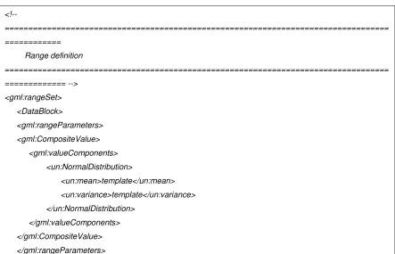
<!--
==================================================================================
============
Range definition
==================================================================================
============= -->
<gml:rangeSet>
<DataBlock>
<gml:rangeParameters>
<gml:CompositeValue>
<gml:valueComponents>
<un:NormalDistribution>
<un:mean>template</un:mean>
<un:variance>template</un:variance>
</un:NormalDistribution>
</gml:valueComponents>
</gml:CompositeValue>
</gml:rangeParameters>
<gml:doubleOrNilReasonTupleList>
2698 26.98 2678 26.78 2657 26.57 2637 26.37
</gml:doubleOrNilReasonTupleList>
</DataBlock>
</gml:rangeSet>
</test:UncertaintyCoverage>
Figure 4. 9 Uncertainty data in GML using uncertainty schema
4.5 User defined distribution
UncertML does not cover all the types of distribution. Sometimes users can define their
own distribution of data to extend UncertML. For example, a user may need to
implement the concept of CEP (circular error probability) [13] in GML. In the military
science of ballistics, CEP is an intuitive measure of a weapon system's precision. It is
defined as the radius of a circle, centered about the mean, whose boundary is expected to
include 50% of the population within it.
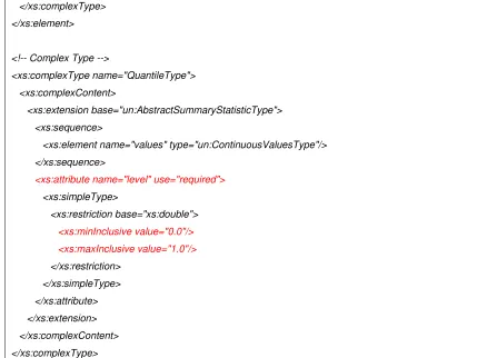
However, there is no definition of circular error type in UncertML. Since the data
structure of quantile in UncertML is similar to CEP we use quantile as base type to
represent the data of CEP.
<!-- Element -->
<xs:element name="Quantile" substitutionGroup="un:AbstractSummaryStatistic">
<xs:complexType>
<xs:complexContent>
<xs:extension base="un:QuantileType"/>
</xs:complexContent>
</xs:complexType>
</xs:element>
<!-- Complex Type -->
<xs:complexType name="QuantileType">
<xs:complexContent>
<xs:extension base="un:AbstractSummaryStatisticType">
<xs:sequence>
<xs:element name="values" type="un:ContinuousValuesType"/>
</xs:sequence>
<xs:attribute name="level" use="required">
<xs:simpleType> <xs:restriction base="xs:double"> <xs:minInclusive value="0.0"/> <xs:maxInclusive value="1.0"/> </xs:restriction> </xs:simpleType> </xs:attribute> </xs:extension> </xs:complexContent> </xs:complexType>
Figure 4. 10 XML schema for quantile in UncertML [4]
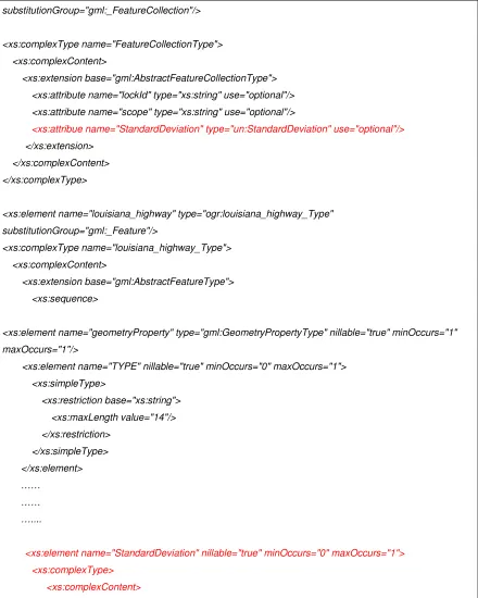
In our application schema, users can define an extended xs:attribute to implement the
concept of CEP.
<xs:element name="FeatureCollection" type="ogr:FeatureCollectionType"
substitutionGroup="gml:_FeatureCollection"/>
<xs:complexType name="FeatureCollectionType">
<xs:complexContent>
<xs:extension base="gml:AbstractFeatureCollectionType">
<xs:attribute name="lockId" type="xs:string" use="optional"/>
<xs:attribute name="scope" type="xs:string" use="optional"/>
<xs:attribue name="CircularErrorProbability" type="un:Quantile" use="optional"/>
</xs:extension>
</xs:complexContent>
</xs:complexType>
![Figure 2. 2 RectifiedGrid definition format[3]](https://thumb-us.123doks.com/thumbv2/123dok_us/8943951.1853319/17.612.110.408.450.669/figure-rectifiedgrid-definition-format.webp)
![Figure 2. 4 Sample RectifiedGrid definition[3]](https://thumb-us.123doks.com/thumbv2/123dok_us/8943951.1853319/18.612.87.522.147.521/figure-sample-rectifiedgrid-definition.webp)
![Figure 2. 6 Sample DomainSetType definition[3]](https://thumb-us.123doks.com/thumbv2/123dok_us/8943951.1853319/20.612.85.525.73.277/figure-sample-domainsettype-definition.webp)