Draft
Sandy
Subbasin Summary
May 17, 2002
Prepared for the
Northwest Power Planning Council
Subbasin Team Leader Greg Sieglitz
Oregon Department of Fish and Wildlife Contributors (in alphabetical order): Karen Bahus, Technical Writing & Research Jason Flory, U.S. Fish and Wildlife Service
Mary Hanson, Oregon Department of Fish and Wildlife Virginia Kelly, U.S. Forest Service
Holly Michael, Oregon Department of Fish and Wildlife Mark Mouser, Clackamas County
Terry Nelson, Natural Resources Conservation Service Russ Plaeger, Sandy Basin River Watershed Council Mike Powers, Multnomah County
DRAFT: This document has not yet been reviewed or approved by
the Northwest Power Planning Council
Sandy Subbasin Summary ii DRAFT May 17, 2002
Sandy Subbasin Summary
Table of ContentsIntroduction... 1
Subbasin Description ... 2
General Description ... 2
Fish and Wildlife Resources ... 19
Fish and Wildlife Status... 19
Habitat Areas and Quality... 78
Watershed Assessment... 86
Limiting Factors ... 87
Artificial Production ... 92
Existing and Past Efforts... 92
Present Subbasin Management ... 99
Existing Management... 99
Existing Goals, Objectives, and Strategies ... 108
Research, Monitoring, and Evaluation Activities ... 132
Statement of Fish and Wildlife Needs ... 136
Sandy Subbasin Recommendations ... 139
Projects and Budgets... 139
Sandy Subbasin Summary iii DRAFT May 17, 2002
Table of Tables
Table 1. Principle aquifers in the Sandy Subbasin ... 8
Table 2. ODFW in-stream water right applications for Sandy Subbasin streams by month ... 10
Table 3. Minimum flow agreements with PGE for flows below Marmot Dam ... 15
Table 4. Federally Listed and Candidate Fish Species in the Sandy Subbasin ... 20
Table 5. Spring chinook run components in the Sandy Subbasin... 23
Table 6. Hatchery spring chinook smolts released in the Sandy Subbasin representing brood years 1979-1990, adult return for each age class, and brood year survival (adult return divided by representative smolt release) ... 29
Table 7. Spring chinook spawner and redd counts in Still Creek and the Salmon River during return years 1989-1995... 31
Table 8. Run size estimate of Sandy fall chinook (LWR) ... 40
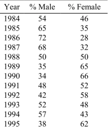
Table 9. Sex composition for Sandy stock (LRW) fall chinook for run years 1984-1995 based on data from spawning ground survey ... 41
Table 10. Monthly passage of Sandy River winter steelhead at Marmot Dam ... 49
Table 11. Monthly counts by PGE of adult summer steelhead at Marmot Dam for run years 1977-1997... 58
Table 12. Hatchery returns, Marmot Dam counts, sport catch, and total run estimates of coho in the Sandy Subbasin ... 61
Table 13. Monthly passage of coho at Marmot Dam for run years 1960-1997... 63
Table 14. Sport angling and harvest of Sandy coho ... 66
Table 15. Confirmed isolated cutthroat and rainbow trout populations existing above barriers in the Sandy Subbasin ... 69
Table 16. Catchable rainbow trout stocking in the Sandy Subbasin, 1987-1994 ... 71
Table 17. Federal and state sensitive, rare, threatened and endangered wildlife species in the Sandy Subbasin ... 74
Table 18. Estimated cropland erosion in the Sandy Subbasin... 81
Table 19. Water quality concerns in the Sandy Subbasin ... 84
Table 20. Major habitat projects completed in the Sandy Subbasin ... 95
Table 21. Clackamas County and ODOT culverts/priority for repair in the Sandy Subbasin... 96
Table 22. Multnomah County culverts/priority for repair in the Sandy Subbasin ... 97
Table 23. FY 2000 Performance Items for the East Multnomah County SWCD... 98
Sandy Subbasin Summary iv DRAFT May 17, 2002
Table of Figures
Figure 1. Oregon Water Resources Department’s administrative boundaries for the Sandy River Basin, which includes the Columbia Gorge tributaries... 2 Figure 2. Hydrograph of stream flows at Sandy River gauge near Marmot, Oregon, January
1980-September 2000... 7 Figure 3. Hydrograph of stream flows at Sandy River gauge below Bull Run River, January
1985-September 2000... 7 Figure 4. Distribution of spring chinook salmon in the Sandy Subbasin ... 22 Figure 5. Trends in run size and harvest of spring chinook in the Sandy Subbasin ... 24 Figure 6. Comparison of average monthly spring chinook escapement over Marmot Dam for years
1960-1970 and 1980-1995... 25 Figure 7. Comparison of Willamette stock spring chinook migratory patterns in the Sandy,
Clackamas, and Willamette Rivers ... 26 Figure 8. Trends in spring chinook run strength, harvest and spawner escapement in the Sandy
Subbasin for three 5-year time periods ... 28 Figure 9. Distribution of fall chinook salmon in the Sandy Subbasin... 35 Figure 10. General spawning time distribution for Sandy fall chinook populations... 37 Figure 11. Comparison of fall chinook sport harvest trends in the Sandy subbasin, and spawning
escapement for run years 1984-1994 based on redd count expansions... 43 Figure 12. Distribution of winter steelhead in the Sandy Subbasin ... 45 Figure 13. Trends in winter steelhead run strength, harvest, and escapement above Marmot Dam
displayed in 5-year averages since 1956 (average escapement for run years 1993-94 is
included for comparison) ... 47 Figure 14. Run timing of winter steelhead at Marmot Dam in percent for four time periods from
the mid-1950s to present (the 1954-56 line represents the historic pre-hatchery influenced time frame) ... 47 Figure 15. Distribution of angler catch and passage of adult winter steelhead at Marmot Dam by
month during the 1961-62 run year ... 48 Figure 16. Cumulative numbers of winter steelhead passing Marmot Dam for six 5-year time
frames (lower portion of bar shows cumulative returns from November through February, upper portion represents March through June) ... 48 Figure 17. Sandy winter steelhead catch by month for pre-hatchery run years (1958-1962) and
during more recent years of hatchery influence (1985-1989) ... 53 Figure 18. Distribution of summer steelhead in the Sandy Subbasin... 55 Figure 19. Average summer steelhead passage at Marmot Dam by month during run years
1984-1993... 56 Figure 20. Distribution of coho salmon in the Sandy Subbasin ... 60 Figure 21. Estimated annual coho spawner escapement at Marmot Dam and hatchery coho returns
Sandy Subbasin Summary 1 DRAFT May 17, 2002
Sandy Subbasin Summary
Introduction
The Sandy Subbasin is a key watershed in north-central Oregon. Its proximity to the Portland metropolitan area, popular sport fisheries, dams and water storage facilities, and habitat quality in the upper subbasin make the management of the fish and wildlife
resources a high-priority endeavor. According to the Sandy River Basin Watershed Council (1999a): “The waterways of the Sandy River Basin and their accompanying watersheds are rich with resources that are part of a heritage that needs to be passed on to future
generations. Here within the basin are scenic treasures, cultural and historical resources, unique geologic formations and other natural features. The diverse landscapes of the watersheds that make up the basin – its forests, wetlands, riparian areas, alpine meadows, anadromous fish habitat, rugged mountain ranges, deep gorge-like canyons, breathtaking vistas, cascading waterfalls, seasonal ranges for wildlife, and more – add a dimension to this geographic region that gives it an importance to many different people in many different ways.”
Although the Sandy River is renowned for its sport fisheries, the winter steelhead, spring and fall chinook, and coho salmon populations are all severely depressed relative to historic levels. This is primarily because dams and other passage impediments have blocked fish passage to upstream habitats, and have changed natural temperature and flow regimes in many subbasin streams. Additionally, while the majority of the upper subbasin falls within federal ownership, much of the fish and wildlife habitat in the subbasin, and especially riparian habitat, has been and continues to be degraded by human activities primarily related to agriculture, urban development, transportation and forestry. These habitat losses present significant opportunities for mitigating fish and wildlife population losses and protecting and restoring the subbasin’s ecosystems.
There are many management efforts on-going in the subbasin to address the causes for these habitat and population losses. This Subbasin Summary attempts to provide a foundation for understanding these losses, the many factors contributing to their decline, and the ongoing programs. The cooperative nature of current programs and coordinating agencies and entities, and the variety of innovative, effective on-the-ground projects are an asset in implementing recovery and restoration efforts. Improving and expanding on existing, successful efforts, including habitat enhancement, passage improvement, research and monitoring activities, is key to meeting restoration goals within the subbasin.
This Subbasin Summary was prepared to meet the need for a facilitated, subbasin project review by the Independent Scientific Review Panel. Termed the “rolling provincial review,” this review and renewal process will establish the budgets and approved activities for existing and newly-funded Bonneville Power Administration (BPA) projects. Also, the Summary is a substantial beginning towards developing the final Sandy Subbasin Plan - a comprehensive document meeting the objectives and standards set forth in the Northwest Power Planning Council’s amended Fish and Wildlife Program and against which future proposed projects will be assessed. These plans will be crucial for implementation of the BPA’s Endangered Species Act responsibilities in its funding decisions.
Sandy Subbasin Summary 2 DRAFT May 17, 2002 Subbasin Description
General Description Subbasin Location
The Sandy Subbasin (Figure 1) is located in the mid-eastern section of the Lower Columbia Ecological Province, within Multnomah and Clackamas Counties in Oregon (EPA Reach 17080001). It drains an area of about 508 square miles (330,000 acres). The Sandy River and many of its tributaries originate high on the slopes of Mount Hood. The Sandy River flows about 56 miles in a northwesterly direction and joins the Columbia River near Troutdale at Columbia river mile (RM) 120.5.
Figure 1. Oregon Water Resources Department’s administrative boundaries for the Sandy River Basin, which includes the Columbia Gorge tributaries
Sandy Subbasin Summary 3 DRAFT May 17, 2002
The Sandy Subbasin is comprised of several watersheds, many of which are uniquely distinct in terms of hydrology and geomorphology. Principal tributaries include the ZigZag River, Still Creek and Salmon River in the upper subbasin, and the Bull Run River, Little Sandy River, Gordon Creek, Cedar Creek and Beaver Creek in the lower subbasin (Figure 1). Many other smaller tributaries located throughout the subbasin contribute significantly to stream flows, and provide habitat for a wide array of fish and wildlife assemblages.
Drainage Area
The Sandy Subbasin drains a portion of northwest Oregon (about 508 square miles), flowing 55 miles from its source on Mount Hood to its mouth at on the Columbia River. The subbasin is part of the Lower Sandy watershed area. The Lower Columbia-Sandy watershed drains about 1,139 square miles, with a perimeter of 189 miles.
The headwaters of the Sandy and ZigZag Rivers are greatly influenced by glaciers and steep unstable slopes on the western flank of Mount Hood, an active volcano with an elevation of 11,235 feet. During summer, glacier ice melts and large quantities of
sediments trapped in the ice flush into associated headwater streams (primarily the Muddy Fork and the upper Sandy River), and the mainstem Sandy River often remains turbid until high elevation temperatures drop in early fall. Glacial sediment and sand deposits are evident throughout the mainstem Sandy River. Snow pack accumulations and glaciers at higher elevations on Mount Hood also maintain favorable flows and cool water
temperatures for fish throughout summer.
The Salmon River and Still Creek are two large-order tributaries in the upper subbasin and are recognized for providing fish high quality spawning and rearing habitat. The Salmon River originates on the south slope of Mount Hood and empties into the Sandy River at RM 38. Still Creek also heads on the south-facing slopes and is a tributary to the ZigZag River. Since most glaciers on the south-facing slopes have mostly vanished due to climatic changes over the past several thousand years, these streams are not presently glacially influenced and do not receive the sediment loads that streams originating from the west and north facing slopes do. The Salmon River usually runs clear all year and provides significant miles of spawning and rearing habitat for both anadromous and resident fish species. Final Falls is a 60-foot high cascade located at about RM 14 on the Salmon River and is the upstream limit of anadromous fish distribution.
The Bull Run River is a large, clear water tributary that enters the Sandy River at Dodge Park (RM 18.5) near the City of Sandy. The mainstem is approximately 25 miles long, and originates from Bull Run Lake (elevation 3,160 feet), a large natural lake to the northwest of Mount Hood. Many large tributary streams also contribute significantly to the flows produced in the Bull Run watershed. Historically, flows from this watershed
represented a significant amount of the average annual flow in the Sandy River entering the Columbia River, and about 32 miles of stream habitat was available to large runs of
migratory fish. However, in 1892 President Benjamin Harrison proclaimed the Bull Run watershed as a reserve for the City of Portland’s domestic water supply. Though the first water diversion structure was built in 1891, it is believed that the Headworks Dam (RM 6;
Sandy Subbasin Summary 4 DRAFT May 17, 2002
20 feet high) was the first facility in the Bull Run watershed to prevent upstream fish passage. In addition, at certain times of the year most of the water draining from this watershed is impounded and transported out of the watershed, primarily for municipal use.
The Little Sandy River is a large tributary stream that empties into the Bull Run River at RM 3. However, fish passage has been blocked since 1911 by a small diversion dam, which is owned and operated by Portland General Electric (PGE) and is located about 1.7 miles upstream from its confluence with the Bull Run River. Other significant tributary streams in the lower basin include Gordon, Beaver, Buck and Cedar Creeks.
Climate
The Sandy Subbasin is considered to have a maritime climate similar to that for western Oregon, which is generally characterized by seasonally mild temperatures and wet winters (Franklin and Dyrness 1973). Precipitation and temperature vary with elevation. Annual precipitation varies from 40 inches near the mouth of the Sandy River to more than 110 inches near its headwaters (Oregon State Parks 1983). The heaviest precipitation occurs during from November through January and the lowest in July and August.
At higher elevations rain precipitates as snow, which may not completely thaw until the end of summer. Snowfall on Mount Hood may average more than 300 inches a year (Green 1983). The Reid, ZigZag and Sandy glaciers, on the west and northwest slopes of Mount Hood, are ice formations developed from large snowfalls occurring annually over thousands of years. Snow that falls in winter combined with stored glacier ice act as reservoirs that consistently release cool flows during the summer. This improves base summer flows and reduces water temperatures, and is important for late spring and summer migrating fish such as summer steelhead and spring chinook. Coho and early migrating fall chinook may benefit as well.
Topography and Geomorphology
The upper Sandy River, ZigZag River and the upper reaches of the Salmon River are very high gradient and carve through unstable volcanic ash and rock deposits. The Sandy River descends from its source at 6,200 feet on the western flank of Mount Hood to an elevation of 1,600 feet at its confluence with the ZigZag River, only 13 miles downstream (NWPPC 1990). The average gradient in the upper subbasin is about 288 feet per mile (NWPPC 1990), but may exceed 1,000 feet per mile in the upper elevations. Substrates underlying the lower reaches of the upper subbasin near the towns of Rhododendron and Zig Zag are typically composed of loose alluvial rock. Substrates in the neighboring Salmon River are composed largely of basaltic lava rock.
The reach of the Sandy River from the confluence with the ZigZag River (RM 43) downstream to Marmot Dam (RM 30) is generally broader and less steep than the upper subbasin. The gradient is moderate and consistent, and averages about 70 feet per mile (fpm) from the confluence with the ZigZag River downstream to the Sleepy Hollow
Bridge, and about 33 fpm from the Sleepy Hollow Bridge downstream to the Marmot Dam (Willamette Canoe and Kayak Club 1994). The substrates in this reach are composed
Sandy Subbasin Summary 5 DRAFT May 17, 2002
largely of small boulders, cobbles and gravel.Glacial sediment deposits may be high where the gradient lessens, and spawning gravels are often entrenched.
Below Marmot Dam, the Sandy River descends for about 5 miles into a scenic narrow gorge that is characterized by steep canyon walls, constrained chutes, and deep trench-like pools. The substrate evident in the strata of the canyon walls is interspersed with basalts, sandstone sediments and compacted volcanic ash conglomerates. Substrates in the active channel are typically composed of large and small boulders because the narrowness of the canyon manifests strong turbulent flows in winter that moves smaller cobble and gravel downstream.
Below Revenue Bridge (RM 24) the active channel widens and the river begins to meander. High bluffs, composed of sandstone and sediments, rise over 200 feet in places. In-channel substrates are generally composed of small boulders and cobble with some gravel deposits at the tail end of the larger pools. Further downstream, the Sandy River merges with the Bull Run River at RM 18.5, and descends into the rugged and remote Sandy River Gorge. The reach from Dodge Park downstream 12.5 miles to Dabney State Park (RM 6) is designated both a federal Wild and Scenic River and a State Scenic
Waterway. Canyon walls are generally composed of sandstone and other sedimentary rock. However, rock and volcanic ash conglomerates are also evident. Overall, in-stream
substrates are composed of small boulders and cobbles with some gravel deposits at the tail end of pools.
Below Indian John Island, the Sandy River lessens in gradient. Overall gradient of the river channel from Dodge Park downstream to Metro’s Oxbow Regional Park (RM 13) is about 23 fpm (Willamette Canoe and Kayak Club 1994). The gradient lessens
significantly, and large gravel deposits are evident at the tail end of most pools. The gradient of the Sandy River from Oxbow Regional Park downstream to Dabney State Park lessens to about 8 fpm, and below Dabney State Park the river continues to its confluence with the Columbia River at gradients of less than 6 fpm (Willamette Canoe and Kayak Club 1994). As the gradient of the channel lessens, large sand deposits become evident.
Where the Sandy and Columbia Rivers merge, sediments have deposited over the millennia to form a large delta. This is called the Sandy River Delta and covers
approximately 1,400 acres (USDA 1996). This land tract was designated a Special Management Area in the 1986 legislature, was purchased by the U.S. Forest Service (USFS) in 1991, and is part of the Columbia River Gorge Scenic Area. The Sandy River Delta was acquired to protect and enhance the natural resource values of the site,
particularly the floodplain character and associated wetlands and to provide for compatible recreation uses. The mouth of the Sandy River is typically shallow and underlain almost entirely with sand and other fine sediments. It is unknown how this shallow condition affects fish passage from the Columbia River into the Sandy, especially in summer and early fall. However, the mouth has some tidal influence and flows from the Sandy are usually adequate for fish passage, even during summer when water levels drop.
Sandy Subbasin Summary 6 DRAFT May 17, 2002
Hydrology
Most water in the Sandy Subbasin is derived from the upper watersheds, primarily in the form of melting snow. Because the upper subbasin’s origin is above tree line, little
vegetation exists to stabilize the banks and sediment inputs and bedload movement is high. Fish production in these high elevation reaches is limited by an extreme gradient and hydrologic turbulence.
In the lower reaches of the upper subbasin, high flows may greatly affect channel configurations as was observed in both the 1964 and 1996 floods. Interestingly, substrates in the neighboring Salmon River are composed largely of basaltic lava rock, and channels are generally more constrained and less prone to large scale shifting during floods
(NWPPC 1990). The hydrological habitat components in the upper reaches of the Sandy and ZigZag Rivers are typically composed of long rapids and riffles interspersed with short pools. In the reach of the Sandy River from the confluence with the ZigZag River (RM 43) downstream to Marmot Dam (RM 30), channels are braided and alder stands are evident on many of the in-stream islands.
Below Marmot Dam, deep trench-like pools characterize the Sandy River, and three boulder-choked rapids make for hazardous passage to drift boats and rafts in this section. Below Revenue Bridge (RM 24) the river is composed mostly of long riffles, rapids and glides. Some pools exist, but are not typically large relative to the width of the active channel. The upper reach of the gorge from the confluence with the Bull Run River down to Indian John Island (RM 15) is characterized by long rapids of moderate gradient and large deep pools. Below Indian John Island, pools are typically large and often deep, and are separated by shorter riffles and glides than the upper section. Below Dabney State Park some channel braiding occurs; however many of the banks are now armored with riprap to protect private property and roads in the lower basin from erosion, which affects the hydrologic mechanisms needed for natural braiding to occur.
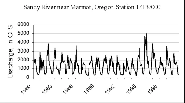
The U.S. Geological Survey measures discharge at several points in the Sandy Subbasin. Figure 2 and Figure 3 display the hydrograph of stream flows (January 1980-September 2000) and the 10-year average discharge by month (1986 to 1995) for gauge 14137000 and gauge 14142500, respectively. Gauge 14142500 is located just downstream of the confluence with Bull Run River (RM 18.5) and is the furthest downstream gauge site location in the subbasin. This gauge reflects cumulative discharge in cubic feet per second (cfs) for most of the Sandy Subbasin (some tributaries, such as Beaver, Gordon and Trout Creeks, are downstream of the gauge and are not represented in the data).
Sandy Subbasin Summary 7 DRAFT May 17, 2002
Figure 2. Hydrograph of stream flows at Sandy River gauge near Marmot, Oregon, January 1980-September 2000
Figure 3. Hydrograph of stream flows at Sandy River gauge below Bull Run River, January 1985-September 2000
The average monthly cfs values at gauge 14142500 for water years 1986-1995 ranged between a low of 377 cfs in September to a high of 3,437 cfs in February. However,
Sandy Subbasin Summary 8 DRAFT May 17, 2002
flows in the Sandy River are variable, ranging widely between days and months within water years. The absolute minimum for the 10-year period was 190 cfs (October 1990), and the absolute maximum was 65,800, during the February flood of 1996. The estimated flow entering the Columbia River (18 miles downstream) was about 85,000 cfs (21.6 feet gauge height) during the February flood event. The estimate exceeded the 1964 flood event when an estimated flow of 82,000 cfs (21.3 feet gauge height) entered the Columbia River (personal communication, River Forecast Center, Portland, 1996).
Discharge during the dry period from June to October at sites 14137000 and
14142500 is similar, but discharge at the lower site (14142500) increases greatly over flow recordings at the upper site (14137000) during the rainy period of November to May. This occurs largely as a result of water storage patterns in the Bull Run River. It should be noted that some tributaries entering the Sandy River between Marmot Dam (RM 30) and the confluence with the Bull Run River (RM 18.5), particularly Cedar Creek, may affect flows measured at the lower site.During the late fall and winter months, after reservoirs in the Bull Run watershed are filled, surplus water is spilled and combines with the Sandy River downstream, which increases the values of the flow data recorded downstream of the Bull Run River. However, during the drier periods of summer, most of the water entering the impoundments in the Bull Run watershed is stored, and therefore, does not contribute to flow measured downstream in the Sandy River. A very high proportion of the water that historically flowed into the Sandy River from the Bull Run watershed is being stored.
Flow regimes in the Sandy Subbasin are greatly affected by high precipitation that falls as rain in the lower elevations and accumulates as snow during winter at higher elevations, primarily on Mount Hood. It is important to understand that fish native to the subbasin have naturally adapted to these local climatic conditions and to the hydrologic profile of the watershed over thousands of years. However, several dams and diversion structures have been constructed in the subbasin over the past century that have greatly modified the river's hydrologic profile and subsequently impacted fish migratory and rearing strategies. The major dams in the watershed are Marmot Dam on the Sandy River (RM 30), the Little Sandy Diversion Dam at RM 1.7 on the Little Sandy River, the Headworks Dam at RM 6 on the Bull Run River, and the Sandy Hatchery weir on Cedar Creek at RM 0.5.
Three types of aquifers make up the Lower Columbia-Sandy watershed (Table 1). The Puget-Willamette Lowland aquifer system and the volcanic and sedimentary-rock aquifer are the two most common.
Table 1. Principle aquifers in the Sandy Subbasin
Aquifer Type Rock Type
Puget-Willamette Lowland aquifer system Unconsolidated sand, gravel Volcanic and sedimentary-rock aquifers Basalt, other volcanic-rock Miocene basaltic-rock aquifers Basalt, other volcanic-rock
Sandy Subbasin Summary 9 DRAFT May 17, 2002
Water Quality
The Oregon Department of Environmental Quality (DEQ) has identified the Sandy Subbasin as water quality limited. These streams are habitat areas for winter steelhead, coho salmon, spring chinook, and fall chinook. Water quality limited means instream water quality fails to meet established standards for certain parameters for all or a portion of the year. Water quality parameters (and standards) of temperature (64°F/55°F,
rearing/spawning), dissolved oxygen (98% saturation), habitat modification (pool frequency), and flow modification (flows) relate to the beneficial use for fish life. Standards for bacteria (fecal coliform) relate to the beneficial use for recreation. The subbasin has three streams on DEQ’s 303(d) list for temperature: the Bull Run River from its mouth to Bull Run Reservoir 2, the Salmon River from its mouth to Boulder Creek, and the Sandy River from its mouth to Marmot Dam. The listing for the Sandy River is likely due to the diversion of water at Marmot Dam for hydropower generation at the Bull Run facility (ODFW 1997).
In-stream Water Rights
Oregon Administrative Rule (OAR) 635-400-005 states: “It is the policy of the Oregon Department of Fish and Wildlife Commission to apply for in-stream water rights on
waterways of the state to conserve, maintain and enhance aquatic and fish life, wildlife, and fish and wildlife habitat to provide optimum recreational and aesthetic benefits for present and future generations of citizens of this state. The long-term goal shall be to obtain an in-stream water right on every waterway exhibiting fish and wildlife values.”
The In-stream Water Right (IWR) Act of 1987 [Oregon Revised Statute (ORS) 537.332] allows the Oregon Department of Fish and Wildlife (ODFW), and the
departments of Parks and Recreation and DEQ to apply for water rights to maintain in-stream flows for designated public uses. The Oregon Water Resources Department (WRD) is the agency responsible for reviewing in-stream water right applications. One provision of the IWR Act provides for the conversion of previously established (prior to September 27, 1987) minimum perennial streamflows to in-stream water rights. Upon conversion, the effective date of the minimum perennial streamflow is retained, giving them seniority over water rights established at a later date.
The ODFW adopted administrative rules (OAR 635-400-000 through 635-400-040) for the IWR program in October 1989. They define ODFW policies and methodologies to be used to determine in-stream flows required for fish and wildlife, and generally govern the agency's internal IWR application process. As required by rule (OAR 635-400-020), ODFW prioritized streams needing in-stream water rights based, in part, on whether the following factors were present: 1) sensitive, threatened, or endangered species; 2) state scenic waterway or federal wild and scenic river status; 3) native anadromous fish species; 4) court-ordered, legislative, or commission mandated priorities; and 5) potential threats to the aquatic ecosystem.
In 1991, ODFW applied for 18 in-stream water rights in the Sandy Subbasin to provide fish with adequate flows at specific times of the year. The priority date for all IWR’s applied for by ODFW in the subbasin is April 30, 1991. In 1996, Final Orders were issued by WRD in cooperation with ODFW for these in-stream water rights (Table 2).
Sandy Subbasin Summary 10 DRAFT May 17, 2002
Some water rights were certified at flow values less than what ODFW originally applied for on April 30, 1991. In order for in-stream water rights to be effective, streamflows must be monitored. In each IWR application, ODFW requests that WRD establish a gauge at an appropriate location if none already exists. The likelihood of this happening for each IWR is very remote, at least in the short term. By law, WRD is responsible for monitoring streamflows and regulating junior users in times of shortage. In reality, WRD is currently not staffed at the field level (Watermasters Office) with sufficient personnel to adequately monitor in-stream flows.
Vegetation
Much of the upland area of the Sandy Subbasin is forested, especially within the National Forest boundary. Alpine plants characterize the upper basin above timberline. At the timberline, mountain hemlock and sub-alpine fir predominate. White bark pine is present but uncommon. Below timberline, mountain hemlock dominates, but western hemlock, true firs, western white pine, and Douglas fir are also common. At elevations of 3,000 to 4,000 feet, a diverse tree and vegetation zone occurs. Species of trees in this location include western hemlock, Douglas fir, true firs, western red cedar, and western larch. Western hemlock and Douglas fir predominate in the forests between 1,000 and 3,400 feet. In general, timber harvest activities have not occurred in most designated wilderness areas of the upper subbasin, and many old growth reserves persist.
In general, most land in lower elevations is privately owned, and logging and agricultural activities may be intense. Land bounding the Sandy River from about Marmot Dam downstream to Sandy is managed for timber, Christmas trees and to a lesser extent livestock. From Sandy downstream to Troutdale, land is primarily managed for nursery stock production, with some farms also in operation. However, the Sandy River from Dodge Park downstream to Dabney State Park is under State Scenic Waterway and Wild and Scenic River status, and a relatively wide corridor of mixed forestland bounds both sides of the river. Urban development in the lower reaches of the Sandy basin has greatly modified natural vegetative communities. Many properties are landscaped with lawns, and non-native flowers and ornamental trees.
Land Uses
The USFS, Mt. Hood National Forest, owns and manages about 70% of the land in the Sandy Subbasin (DEQ 2001). The remaining land is in private ownership (22%), 4% is owned by the Bureau of Land Management, 2% is owned by the City of Portland, and the remainder owned by the state, local government, or PGE (DEQ 2001). About 19.5% of the land is designated as wilderness. Forests cover about 85% of the subbasin. Public land includes the Salmon-Huckleberry (44,600 acres) and Mount Hood (47,160 acres) Wilderness Areas. The subbasin has nearly 60 river miles of National Wild and Scenic River designations including the Sandy River from Dodge Park to Dabney State Park (also a state scenic waterway); the upper Sandy River from its headwaters to the boundary of the Mount Hood National Forest; and the entire Salmon River.
Sandy Subbasin Summary 11 DRAFT May 17, 2002
Table 2. ODFW in-stream water right applications for Sandy Subbasin streams by month CFS/month Stream > Parent Stream App. No. Jan- Feb Mar-
May Jun Jul Aug Sep Oct
Nov- Dec Alder Cr > Sandy R 71544 25 25 15/10 8/5 4 4 4/25 25 Beaver Cr > Sandy R 71545 14 14 3/2 1 1 1 1 14 Boulder Cr > Salmon R 71546 30 30 20/10 8 5/4 3 3/30 30 Camp Cr > ZigZag R 71547 25 25 20 20 15 15 15/25 25 Cedar Cr > Sandy R 71548 60 60 40/20 10 10 10/20 40 60 Cheney Cr > Salmon R 71549 35 35 20/10 8 5/4 3 3/35 35 Clear Fork > Sandy R 71550 25 25 20/15 12 8 8 8/25 25 Gordon Cr > Sandy R 71552 50 50 30/20 15 15 15 20/50 50 Henry Cr > ZigZag R 71553 18 18 10/7 4/3 2 2 2/18 18 Lost Cr > Sandy R. 71555 20 20 15 15/12 12 12 12/20 20 S Fk Salmon > Salmon R 71560 35 35 20/10 8 5 5/8 15/35 35 Salmon R > Sandy R 71557 250 250 250 150/125 100/80 80/250 250 250 Salmon R > Sandy R 71558 150 150 150 120/90 60 60/100 150 150 Sandy R > Columbia R 71480 1,900 2,000 1,400 850 400 500 650 1,500 Sandy R > Columbia R 71559 250 250 250 150/100 100 100/250 250 250 Still Cr > ZigZag R 71561 60 60 50/40 30/25 25 25/60 60 60 Trout C > Sandy R 71562 35 35 20/5 4/3 3 3 5/20 35 ZigZag R > Sandy R 71563 200 200 150 100 75 75/200 200 200
Note: CFS data entered as 15/10 means that the in-stream water right is 15 cfs for the first half of the month and 10 cfs for the latter half of the month
Agricultural Practices
Agriculture in the Sandy Subbasin consists primarily of nursery stock production based largely on the plateaus of the lower watershed east and north of Gresham and south of Troutdale. Beaver Creek is a medium-sized tributary to the lower subbasin that is greatly affected by agricultural practices in these areas. Beaver Creek is typically turbid following
Sandy Subbasin Summary 12 DRAFT May 17, 2002
even light rainfall, and sediment deposits are evident in low gradient areas in the lower subbasin near Troutdale (general observations, Tom Murtagh, ODFW, 1994 and 1995).
Some land is also used for agricultural purposes in the hills on the north shore of the Sandy River. Activities associated with agricultural practices that are of concern are land clearing, tilling, ditching, draining of wetlands, road building, heavy machinery use and applications of fertilizers and herbicides that can leach into streams. Also, vegetation along some tributary streams may be removed to gain access to streams or increase the production potential of the land.
Urbanization
The human population of the Sandy Subbasin has been growing ever since settlers
following the Oregon Trail began arriving in the 1840s. Incorporated cities in the subbasin include Rhododendron, Zig Zag, Government Camp and Sandy. Portions of the cities of Gresham and Troutdale lie within the lower part of the subbasin. The 2000 Census shows growth in the subbasin continued at a rapid pace during the 1990s. The City of Troutdale increased by 75% to 13,777 while Gresham grew by 32% to 90,205 and Sandy grew to 5,385, or a 29% increase. Additional growth is expected in the coming decade and will put further demands on the subbasin’s natural resources. The probable impacts on fisheries related to urbanization include the following:
• Direct loss of stream and riparian habitat to road building and residential and commercial construction.
• Loss or partial obstruction of upstream and/or downstream fish migration by culverts and bridges.
• Increased winter streamflows and reduced summer streamflows caused by increased impervious surfaces, stormwater runoff, and diversions.
• Reduced water quality from elevated stream temperatures, chemical contamination, and increased sediment loading and deposition.
• Increased disturbance, harassment, and poaching of adult salmonid spawners. • Increased disturbance by pets and livestock.
• Increased potential for toxic spills.
• Cumulative negative effects on the biotic and ecological integrity of the aquatic environment and consequent associated impacts on fish.
• Filling of wetlands and reduction of aquifer storage, which may impact downstream areas by overloading channels with water during storms.
Mining
Mining of minerals, rock or sand within the active channels of the watershed is currently not a great concern. Many miles of both the upper Sandy River and Bull Run River
watersheds are protected by wilderness or municipal water use status. Twelve miles of the lower mainstem Sandy River, from Dodge Park (RM 18.5) downstream to Dabney State Park (RM 6) is also protected by both State Scenic Waterway and Wild and Scenic River status. Homeowners control significant miles of shoreline both above and below these boundaries. It should be noted that sand and gravel were historically extracted from the
Sandy Subbasin Summary 13 DRAFT May 17, 2002
beds within the active channels of the lower subbasin near Gordon Creek and Troutdale for commercial and domestic use, however it is unknown if pursuit of this kind of venture in the lower subbasin will be renewed.
Grazing
Livestock grazing in the watershed is considered to be light and is not thought to greatly affect overall fish habitat quality in the subbasin. The horse and cattle grazing activities that do occur are generally located on the plateau above the river corridor.
Impoundments and Irrigation Projects
Irrigation is not extensive in the subbasin. Only about 3,000 acres are irrigated which occurs mostly along the lower portion of the Sandy River, downstream from the City of Sandy (SRBWC 1999a). There are impoundments in the subbasin associated with
hydropower production and municipal water use as described in the following paragraphs. Bull Run Watershed
The Bull Run River watershed, located in the 95,382-acre Bull Run Watershed
Management Unit, is managed primarily as the City of Portland’s domestic water supply [under Public Law (PL) 95-200]. Efforts to divert water from the Bull Run River were initiated about 1891, and in 1892 President Benjamin Harrison, established the Bull Run Reserve to insure the continued supply of high quality potable drinking water for Portland. In 1904, federal legislation closed the watershed to public entry. Fishing, hunting, and other recreational uses have not been allowed in the Reserve since that time.
The first conduit and water diversion was constructed in 1891 at the site of the present Headworks Dam, located approximately 6 miles above the mouth of the confluence with the Sandy River (Whitt 1975). Records are poor regarding the general description of this facility, and consequently it is unknown if fish were able to pass around the structure or were blocked from upstream migration. However, in 1922 the Headworks Dam was built 22 feet high, and no fish passage was provided. About 28 miles of stream habitat, once used by large runs of coho, winter steelhead, spring and fall chinook, and migratory trout have been blocked for nearly 75 years. The habitat loss represents a significant proportion of the in-stream habitat in the entire subbasin once available to migratory fish. Important populations of rainbow, cutthroat, whitefish and other fish species thrive in the reservoirs and tributaries above these dams, however.
Water management in the watershed has also significantly altered the hydrological profile of the 6-mile reach below the Headworks Dam, and has greatly impacted the spawning and rearing potential for fish in this area. In accordance with a 1984 agreement between ODFW and Portland, Portland compensates for the loss of natural fish production in the Bull Run River by funding the production of 32,000 pounds of hatchery smolts (presently 160,000 spring chinook and 60,000 winter steelhead).
The Ben Morrow Dam, referred to as Bull Run Dam No. 1, was built in 1929 near the confluence of Bear Creek and the Bull Run River. The structure is about 200 feet high, and maximum surface elevation of the reservoir is 1,045 feet. The storage capacity of the
Sandy Subbasin Summary 14 DRAFT May 17, 2002
reservoir is 10 billion gallons. During the years 1958-1963, Bull Run Dam No. 2 was constructed at RM 6.2, just upstream of the Headworks Dam. This dam is 118 feet high and the spillway is located on an arm of the reservoir downstream of the dam. Maximum surface elevation is at 860 feet and the storage capacity is 7 billion gallons.
Bull Run Lake, a naturally formed body of water, is located in the headwaters of the Bull Run watershed. In 1915, a 10 foot high rock and log crib structure was built at the outlet of the lake to raise its storage capacity. The maximum surface elevation of the lake is 3,178 feet, and the storage capacity is about 4 billion gallons. The lake is a backup water reserve to the lower elevation reservoirs during dry spells. An important population of wild cutthroat trout exists in the lake and spawn in small tributary streams that enter the lake. The USFS, in cooperation with the City of Portland, ODFW and other stakeholders, developed the Bull Run Lake Special Use Authorization and Lake Level Management Plan. Under guidelines defined in the plan, the USFS issued a long-term (20 year) Special Use Authorization that continues to allow the Portland Water Bureau to manage their existing facilities at Bull Run Lake. Actions defined in the USFS management plan address conservation of trout in the lake, and are largely aimed at maintaining access into small spawning streams by sustaining an adequate lake level needed to facilitate trout migrations during spawning timing, and providing floating cover during excessive drawdown periods. A small reservoir was once located in the North Fork of the Bull Run River near its headwaters. The impoundment was called Boody Lake, and stored about 0.4 billion
gallons. The reservoir currently does not store water for municipal use. Also, other sites in the Bull Run Watershed have been under review by the Portland Water Bureau for
additional storage under the Regional Water Supply Plan. Bull Run Dam No. 1 and No. 2 were originally designed to produce hydropower, but were not retrofitted to produce power until the early 1980s. Since 1958, Portland has also sold water to PGE, which is diverted to Roslyn Lake for additional power production.
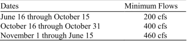
Marmot Dam and the Little Sandy Diversion Dam
Hydropower development in the Sandy Subbasin was initiated in 1906 by the Mt. Hood Railway and Power Company, an electric utility that later merged with a PGE predecessor (PGE TAC Meeting, April 1994). Construction of the Bull Run Powerhouse on the lower Bull Run River (RM 2) and the Little Sandy Diversion Dam, located at RM 1.7 on the Little Sandy River, were completed by 1912 (PGE 1991). The Little Sandy Dam is about 16 feet high, and diverts water through a 17,000-foot long flume to Roslyn Lake. This lake is a 140-acre impoundment and is the forebay for the Bull Run Powerhouse.
Construction of Marmot Dam on the mainstem Sandy River (RM 30) was finished in 1913 to provide additional water for power production. Marmot Dam was originally a wood crib dam, but was rebuilt with concrete in 1989 under Federal Energy Regulatory Commission (FERC) requirements, as structural failure was feared. The dam is 30 feet high, and diverts water from the Sandy River to the Little Sandy River via a network of canals and a 4,690-foot long tunnel excavated under a mountain ridge that divides the two basins. The diversion canal has a flow capacity of 600 cfs. Sandy River water combines with the Little Sandy River and is then diverted to Roslyn Lake through a wood-box flume that parallels the Little Sandy along its south bank. The flow capacity of the diversion canal
Sandy Subbasin Summary 15 DRAFT May 17, 2002
between the Little Sandy Diversion and Roslyn Lake is 800 cfs. Generally, all water from the Little Sandy River is diverted, and water diverted from the Sandy River makes up the additional quantity needed to maximize flow in the canal. However, flow capacity in the canal may not be reached during low flow periods, usually in summer, because PGE is required to meet minimum flow requirements, established in 1975, for fish passage below Marmot Dam (Table 3). If flows in the Sandy River at Marmot Dam drop below minimum flow agreements, then water is not diverted from the mainstem Sandy River.
Table 3. Minimum flow agreements with PGE for flows below Marmot Dam
Dates Minimum Flows
June 16 through October 15 200 cfs October 16 through October 31 400 cfs November 1 through June 15 460 cfs
Portland General Electric operates Marmot Dam and the Little Sandy River diversion project under FERC hydroelectric license #477, which was issued in 1980 and will expire in 2004. When the project comes up for re-licensing in 2004, a number of fish issues will be raised including minimum flows in the Sandy River below Marmot Dam and in the Little Sandy River below the diversion dam, upstream and downstream fish passage, and hatchery compensation.
Water is impounded in Roslyn Lake, which has a gross capacity of 2,000 acre-feet. Water flows down to the PGE powerhouse through two 1,400-foot long penstocks
extending from the northern edge of the reservoir. Water drives four horizontal turbine generators, each with a nameplate rating of 5,250 kW, for a total of 21,000 kW.
Portland General Electric operates under FERC license #477, and is required to maintain the fish ladder at Marmot Dam for upstream fish passage. The fish ladder, located on the south bank, was rebuilt in 1983. Upstream fish passage in the ladder is believed to be adequate. They are also required to maintain a fish counter at the facility to provide ODFW and the public with reliable daily fish counts. The counter was upgraded in 1996 because the previous counter was unreliable.
The FERC license #477 also requires that PGE maintain rotating diversion screens and a downstream juvenile bypass facility in the Marmot Dam diversion canal. The canal was unscreened until 1951, and prior to this date, it is believed that large numbers of fish naturally produced in the watershed above the dam were diverted into the canal and to Roslyn Lake. Several studies have been conducted on the juvenile bypass system that review how the system works and what modifications have occurred at the facility to improve juvenile bypass efficiency (Wagner 1959, Leonards 1960, and Cramer 1993).
The rotating screens and juvenile downstream bypass facility are located in the diversion canal 700 feet downstream of Marmot Dam. The canal leading to the bypass facility is trapezoidal in cross section, with the top and bottom dimensions 27 and 13.5 feet, respectively (Cramer 1993). The depth is 9.5 feet and the gradient in this section is 0.1% (Cramer 1993).
Sandy Subbasin Summary 16 DRAFT May 17, 2002
The rotating screens are composed of three traveling screen units, set side by side at a 90-degree angle to flow (Cramer 1993). Each unit consists of 26 screen panels, composed of wire mesh with 1/8-inch openings. Electric motors drive the screens at a rate of 8 feet per minute (Cramer 1993). There are 10 vertically-aligned fish collection ports to divert fish back to the river. Three ports are located on each sidewall of the canal, and two ports are located on each vertical column separating the screen section (Cramer 1993). Fry caught on the rotating screens are flushed by water from spray nozzles into a trough located in front of the screens. These fish are then flushed into the bypass transport pipe and
deposited into a holding pond near the shore of the Sandy River. Fish then swim
volitionally into the river at this point. A juvenile trap also exists at the pond site, and has been used to capture experimental fish.
The FERC license #477 required that PGE study the Marmot canal fish screen and bypass with cooperation and concurrence of the fisheries agencies (Cramer 1993).
Numerous modifications have been made to the screen and bypass since that time, and major changes reported by Cramer (1993) include:
• Increasing the number of bypass ports in use from 3 to 10.
• Changing the 24-inch bypass culvert to a 36-inch fiberglass lined conduit increasing the bypass flow to 60 cfs.
• Reducing the screen openings from 3/16 inch to 1/8 inch.
• Adding a second set of screen nozzles to the screen wash system.
• Adding a second set of baffles approximately 20 feet upstream of the screens to provide a more even flow.
In addition, Cramer (1993) reports the following operating criteria have been established pursuant to fish migrant studies to maximize fish survival at the rotating screens and downstream juvenile bypass facility at Marmot Dam:
• The fish bypass operates whenever water is diverted into the canal.
• The canal screens are run continuously from March 1 through May 31 when fry are present.
• The screen wash water spray pressure is maintained at 30 psi from March 1 through May 31.
• Flow in the bypass is maintained at approximately 60 cfs to keep velocities entering ports at 2 feet per second.
• When large numbers of smolts are observed in front of the screens, water level in the canal is dropped so fish can be flushed through the bypass and back to the river. In summary, based on evaluation of the downstream juvenile migrant bypass facility at Marmot Dam, Cramer (1993) concluded that though the proportion of
downstream migrants diverted into the canal is unknown, an estimated 95.4% of the fry bypassed survived. In addition, an estimated 97.3% of hatchery steelhead test smolts and 95% hatchery spring chinook test smolts survived the bypass system (Cramer 1993).
Sandy Subbasin Summary 17 DRAFT May 17, 2002
Though the rotating screens and bypass facility have undergone improvements since 1981, the ODFW has the following concerns in regards to the bypass facility:
• The rotating screens designed to divert salmonid fry are perpendicular to the flow and do not provide an acceptable sweeping velocity to prevent impingement. • Fry survival and bypass is highest when canal surface water elevation is between
2.7 to 4.0 feet, probably because the top fish diversion port openings are at surface elevation 2.67 to 4.2 feet.
• Spray pressure from the screen wash water affects fry survival and a spray psi of 30 seems to provide the best survival over the ranges tested;
• Some delays to smolt and fry migration may occur.
• The spray wash system is presently not operated year round and should be operated year round to ensure adequate passage is provided all year.
The ODFW has concluded that the screens and bypass system at Marmot Dam currently fall below agency operational criteria and that the facility should be redesigned as a condition of a new license when the existing license expires. The ODFW also has the following fish management concerns in regards to PGE hydropower impacts on the fish resource of the subbasin:
• Lost anadromous fish habitat above the Little Sandy River diversion dam, and reduced flows in the 1.7-mile reach below the diversion dam.
• Spill may occur at the Little Sandy diversion dam during high water events, and attract migratory fish up to the diversion dam. When flows abate, fish attracted upstream in the Little Sandy River may become stranded and die when the channel below the diversion waters.
• Mitigation agreements for lost habitat in the Little Sandy River; Portland General Electric presently compensates the production of 12,000 pounds of hatchery fish (presently 100,000 spring chinook smolts).
• Changes in the hydrological profile in the 11-mile reach below Marmot Dam. • Temperature differences that may exist during summer in the Sandy and Bull Run
Rivers at the point of confluence as a result of flow manipulations.
• Water leaving the Bull Run River is mixed with water diverted from the Sandy River, and this may promote straying of wild and hatchery fish into the Bull Run watershed where spawning and rearing habitat has been severely degraded.
Mitigation Agreements and FERC License Requirements
The City of Portland and PGE presently compensate for lost fish production caused by in-stream habitat losses or impacts resulting from hydropower and municipal water supply development in the Sandy Subbasin. A large portion of the winter steelhead and spring chinook hatchery production destined for release in the Sandy River are tied to FERC license requirements. Presently, Portland funds the production of 60,000 hatchery winter steelhead smolts (12,000 pounds) and 160,000 spring chinook smolts (20,000 pounds) as compensation for lost habitat caused by the development of hydroelectric production
Sandy Subbasin Summary 18 DRAFT May 17, 2002
facilities in the Bull Run River. Provisions for compensation are stipulated in Portland’s FERC license #2821 for these projects (expires in 2029). The agreement between Portland and ODFW pertaining to this requirement was signed in 1984 and only provides for lost annual natural production since that time. However, this agreement resolved all “past claim” disputes. It should be noted that the requirements in the FERC license did not address migratory trout or other migratory fish species.
Unfortunately, no comprehensive records exist that accurately quantify the numbers of fish that historically returned to the Bull Run River. In order to determine the lost natural fish production potential of the Bull Run River due to municipal water supply and
hydroelectric power development, the ODFW evaluated old hatchery egg take records from the early 1900s of fish intercepted at the Salmon River Hatchery to estimate the size of the potential fish runs in the Bull Run River prior to dam construction. It was assumed that because of geomorphological and hydrological similarities between the Bull Run River and the Salmon River, that runs returning to these basins may have also been similar. It was estimated that potential annual production of wild fish from Salmon River was at least 1,530-spring chinook, 725 steelhead, and 1,050 coho, or a total of 3,505 anadromous fish. Compensation for lost natural production in the Bull Run River was agreed to be 60,000 hatchery winter steelhead smolts and 20,000 pounds of hatchery spring chinook smolts (160,000). These hatchery smolts are released in the Sandy River below Marmot Dam, primarily to support sport and commercial fisheries interests.
Similarly, PGE funds the production of 100,000 hatchery spring chinook smolts (about 12,000 pounds) for lost salmonid habitat in the Little Sandy River. It should be noted that lost natural production of coho and winter steelhead in the Little Sandy River was used to calculate the compensation of equal pounds in hatchery produced spring chinook. The ODFW decided that funding for lost natural production of coho and winter steelhead should be used for production of hatchery spring chinook. Coho and winter steelhead programs at that time were already federally funded, and it was thought that greater benefits would be realized by enhancing the spring chinook program. From various records it was determined that the Little Sandy River could once have naturally produced as many as 846 adult coho and 706 adult steelhead (ODFW intradepartmental memo from Lou Fredd, October 4, 1979).
The agreement between ODFW and PGE was signed in 1983 and is incorporated as a requirement of FERC license #477. The compensation requirements did not address lost fish production prior to the signing of the agreement, nor did it address lost habitat for migratory trout or other migratory and non-game fish species. In addition, the Little Sandy diversion dam is not screened, and downstream migrant trout naturally produced in the basin upstream are probably diverted into Roslyn Lake. The re-licensing period for PGE’s Little Sandy River diversion is 2004.
Protected Areas
Nearly 60 river miles in the Sandy Subbasin are protected by Wild and Scenic River status. In 1968, Congress passed the National Wild and Scenic Rivers Act (P.L. 90-542), which was intended to create a system of outstanding free-flowing rivers in the United States. In 1988, the Omnibus Oregon Wild and Scenic Rivers Act (P.L. 100-557) amended the 1968
Sandy Subbasin Summary 19 DRAFT May 17, 2002
Act, designating the following reaches: 1) the Sandy River from Dabney State Park (RM 6) upstream to Dodge Park at RM 18.5 (Lewis 1993), 2) the Salmon River in its entirety from its headwaters on Mount Hood downstream to its confluence with the Sandy River at RM 38, and 3) the upper Sandy River from its headwaters on Mount Hood downstream 12.4 miles to the USFS Boundary near RM 44. Reaches within each Wild and Scenic segment are classified and managed as wild, scenic, or recreational depending on the level of development and access present at the time of the designation.
Relation to Federal Columbia River Power System
While no hydropower dam and reservoir complex is operated by a federal agency in the Sandy Subbasin, there are private facilities licensed through FERC and numerous
powerlines and infrastructure which are operated in conjunction with the Federal Columbia River Power System (FCRPS) to provide power to the Northwest power grid system. In addition, the Sandy River Delta and lower subbasin areas were directly affected by the construction and the operation of the FCRPS, especially nearby Bonneville Dam.
Therefore, the impacts from these FCRPS activities on subbasin fish and wildlife resources form the core of information around which this Subbasin Summary is developed.
Fish and Wildlife Resources
Fish and Wildlife Status Fish
The Sandy Subbasin is home to 19 native and 14 introduced fish species. Prior to the 1800s, anadromous and resident fish populations flourished in the subbasin’s pristine environment full of shallow gravel beds, deep pools, and cool mountain stream flows (Taylor, 1998). Native anadromous fish species included winter and summer steelhead trout, fall and spring chinook salmon, and coho salmon. Historically, it has been estimated that fish runs as high as 15,000 coho, 20,000 winter steelhead, 10,000 fall chinook, and 8,000-10,000 spring chinook once returned each year to spawn in the subbasin (Taylor, 1998). Large populations of cutthroat trout (resident and migratory forms), bull trout, rainbow trout, mountain whitefish, pacific lamprey, and other resident fish also were found in the subbasin.
By the late 1800s, development within the subbasin also began to affect fish production. Widespread timber harvest, driving logs down river to mills, road building, agricultural production, and other development, especially in the lower basin, damaged pristine habitat areas. In 1887, hatchery egg-take operations on the Salmon and Sandy rivers captured many fish returning to upper basin spawning grounds (Taylor, 1998). Also, the building and operating of several dams in the basin during the early 1900s also
seriously affected fish habitat and production. On the Little Sandy River, salmon and steelhead lost access to about 6.5 miles of spawning and rearing habitat after construction of the diversion dam. The Headworks Dam built on the Bull Run River blocked salmon and steelhead from about 37 miles of habitat in the upper drainage. Flow diversions at both
Sandy Subbasin Summary 20 DRAFT May 17, 2002
dams restricted fish production in the lower river sections. Marmot Dam, constructed in 1913, hindered the upstream and downstream migration of fish and flow diversions often left little water in the Sandy River below the dam, which limited fish production.
Today, the subbasin’s anadromous fish runs have fallen far below historic levels. Comparisons of old hatchery records and recent spawning surveys suggest that current adult returns are only 10% to 25% of 1890 levels, and hatchery-reared fish now dominate the runs (Taylor, 1998). Many of the salmonid populations in the subbasin are currently under stress (Table 4).
Table 4. Federally Listed and Candidate Fish Species in the Sandy Subbasin
Fish Species Status Federal Register
Chinook Salmon (Oncorhynchus tshawytscha)
Lower Columbia ESU Threatened 64 FR 14308; March 24, 1999 Steelhead (Oncorhynchus mykiss)
Lower Columbia ESU Threatened 63 FR 13347; March 19, 1998 Coho Salmon (Oncorhynchus kisutch)
Lower Columbia/SW Washington ESU Candidate 60 FR 38011; July 25, 1995
Spring Chinook Salmon
Figure 4 shows the distribution of spring chinook salmon (Oncorhynchus tshawytscha) in the Sandy Subbasin. Historically, strong healthy runs of native spring chinook salmon ascended the Sandy River and its tributaries. Mattson (1955) reported that between 8,000 and 10,000 wild spring chinook may once have returned to the watershed (5,000 to the Bull Run River and 3,000-5,000 to the upper subbasin). However, municipal water supply development in the Bull Run River and water diversions from the mainstem Sandy at Marmot Dam beginning in the early 1900s severely impacted natural production capability of spring chinook in the subbasin. In addition, adult spring chinook were trapped at Marmot Dam in many years up through the 1950s for artificial propagation. The Marmot Dam diversion canal was not screened until 1952, and at the time, fisheries managers felt that it was not justifiable to allow adult salmon to spawn above the dam only to have a large proportion of out-migrating juveniles diverted from the mainstem and into Roslyn Lake.
In addition, ocean and Columbia River commercial and sport fisheries also impacted the run. Passage of wild spring chinook at Marmot Dam dwindled to near zero during some run years in the 1950s as a result of these cumulative effects. However, based on District reports from anonymous authors in the 1950s, small numbers of spring chinook continued to spawn in the lower basin below Marmot Dam based on old survey records.
Hatchery spring chinook have been released in the Sandy River since the early 1900s. Though mostly fry and presmolts of Sandy origin were released up through 1969, a more focused hatchery program was initiated in the early 1970s to supplement the depleted native run with Willamette stock spring chinook. However, Carson stock (Washington)
Sandy Subbasin Summary 21 DRAFT May 17, 2002
was used in 1977 and 1978. Presently, about 460,000 hatchery spring chinook smolts, Willamette stock from the Clackamas Hatchery, are released annually into the Sandy River. Since the early 1980s, Portland and PGE have provided funding to support the production of 260,000 of these smolts under FERC requirements to mitigate for lost fish production in the Bull Run and Little Sandy watershed (see Hatchery section). The spring chinook return has increased markedly over the past 15 years (Table 5; Figure 5) largely in response to hatchery releases in the watershed (see Abundance section for rationale). The estimated five year average return for run years 1990-94 was 5,118 (Table 5; Figure 5).
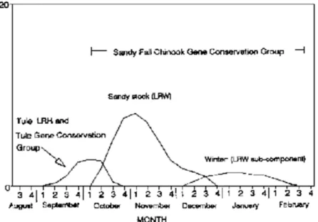
Though it is believed that most spring chinook returning to the subbasin are of hatchery origin, natural production continues to occur primarily above Marmot Dam in the larger clear water tributaries and is believed to be making a contribution to the spring chinook run in the Sandy River. Many miles of spawning and rearing habitat are in reaches of the watershed that are under “Wilderness” or “Wild and Scenic River” status, and also exist above areas that are heavily influenced by flow manipulations. Spring chinook adults and redds are counted each year in Still Creek by USFS personnel from the Zigzag Ranger District and spawning activity is documented in other neighboring streams.
Naturally produced juvenile spring chinook out-migrants, both 0+ and 1+ fish, have also been trapped annually in Still Creek by the USFS since 1986. Naturally produced juvenile spring chinook have also been observed by snorkel surveys in Still Creek and the Salmon River during the summer. However, the proportion of the spring chinook spawning escapement that originates from natural production or directly from hatchery returns is unknown as only a small percent of the hatchery spring chinook smolts originating from the Clackamas Hatchery are marked (about 5% in some years).
Though a significant amount of spawning activity is observed in the upper subbasin each year, genetic introgression between any remnant returns of native Sandy spring
chinook and the large numbers of hatchery Willamette stock spring chinook has probably occurred. It is unknown if the indigenous stock of Sandy River spring chinook has sustained itself as a separate subpopulation from the introduced Willamette stock.
The ODFW presently list spring chinook that return to the Sandy Subbasin in the Willamette spring chinook Gene Conservation Group, which also includes populations that return to the McKenzie, Santiam, Molalla and Clackamas rivers, all major tributaries to the Willamette River. Willamette stock spring chinook are now managed in the Sandy
Subbasin for both hatchery and natural production. It is probable that Willamette stock spring chinook have become adapted to the Sandy Subbasin and a portion of the run is now represented by naturally produced Willamette spring chinook.
The importance of sustaining a naturally produced population of Willamette stock spring chinook in the Sandy River has emerged because wild runs in the Willamette Basin are declining. All hatchery spring chinook smolts have been released in the lower subbasin below Marmot Dam since 1994 to reduce competition with the naturally producing
Sandy Subbasin Summary 22 DRAFT May 17, 2002
Sandy Subbasin Summary 23 DRAFT May 17, 2002
Table 5. Spring chinook run components in the Sandy Subbasin
Marmot Sport Catch1 Minimum Harvest Estimated
Year Counts2 Bull Run Sandy River Sandy River Run Rate Spawning
River (below Marmot)3 (above Marmot)4 Estimate (%) Escapement
1954 400 -- -- -- -- -- -- 1955 5 -- -- -- -- -- -- 1956 0 -- 354 -- 354 -- -- 1957 10 -- 156 -- 166 -- -- 1958 78 -- 246 -- 324 -- -- 1959 304 -- 383 -- 687 -- -- 1960 23 -- 126 -- 149 -- -- 1961 37 -- 33 -- 70 -- -- 1962 65 -- 32 -- 97 -- -- 1963 124 -- 67 -- 191 -- -- 1964 660 -- 29 -- 689 -- -- 1965 13 -- 38 -- 51 -- -- 1966 63 -- 29 -- 92 -- -- 1967 51 -- 35 -- 86 -- -- 1968 61 -- 28 -- 89 -- -- 1969 81 -- 83 -- 164 -- -- 1970 137 -- 112 -- 249 -- -- 1971 -- -- 60 -- -- -- --- 1972 -- -- 37 -- -- -- -- 1973 -- -- 89 -- -- -- -- 1974 -- -- 36 -- -- -- -- 1975 -- -- 274 -- -- -- -- 1976 -- -- 159 -- -- -- -- 1977 -- -- 275 -- -- -- -- 1978 607 12 116 -- 735 -- 556 1979 267 15 597 -- 879 -- 245 1980 553 9 1,260 -- 1,822 -- 506 1981 1,087 15 1,739 -- 2,841 -- 996 1982 525 3 854 -- 1,382 -- 481 1983 561 44 1,259 -- 1,864 -- 514 1984 1,212 38 1,124 -- 2,374 -- 1,110 1985 566 8 875 -- 1,449 -- 518 1987 1,421 0 932 -- 2,353 -- 1,302 1988 1,947 12 972 50 2,931 35 1,897 1989 1,413 4 587 63 2,004 33 1,350 1990 1,614 16 1,897 145 3,527 58 1,469 1991 1,904 9 1,739 202 3,652 60 1,702 1992 7,011 3 1,537 683 8,551 26 6,328 1993 4,389 12 1,968 436 6,369 38 3,953 1994 2,319 3 1,176 143 3,498 38 2,176 1995 1,503 -- -- -- -- -- --
1. Counter not in operation from 1971 through 1977.
2. Counter failed June 1992; count is estimated based on average June return for previous years.
3. Problems with installation of new camera system during spring and summer 1996; counts are estimates based on proportions of fish counted by the electronic counter.
Sandy Subbasin Summary 24 DRAFT May 17, 2002
Figure 5. Trends in run size and harvest of spring chinook in the Sandy Subbasin
Run Timing and Spawning Distribution
Spring chinook may enter the Sandy River as early as February, but peak movement into the subbasin typically occurs in April and May according to angler reports (see Angling section). Willamette stock spring chinook have been harvested in the Willamette River below Willamette Falls as early as January in some years (personal communication, Curt Melcher, ODFW, 1996), and possibly some bright “winter” chinook reported in January and February by anglers on the Sandy River may be early returning spring chinook.
Spring chinook typically migrate into the upper subbasin above Marmot Dam from May to early October (Figure 6); however, some migrants are observed as early as April and as late as November. It may be that chinook counted in late October and November are actually late maturing fall chinook that are attracted into the upper basin when flows permit (see Fall Chinook section). Peak migration over Marmot Dam generally occurs in June, and for run years 1980 to 1995, 30% of the spring chinook count occurred in this month (Figure 6). Passage at Marmot Dam then decreases in summer, probably in response to drops in flow and increases in water temperature. A second but smaller peak often occurs in September as water temperatures again decrease. For run years 1980-1995, 15% of the spring chinook count at Marmot Dam occurred in September, and an additional 5% of the run occurred in October (Figure 6). This is a concern because cumulatively, about 20% of the spring chinook run that pass Marmot Dam is holding in the lower subbasin for most of the summer in areas that are greatly influenced by flow manipulations and temperature differences, which may affect survival.
Sandy Subbasin Summary 25 DRAFT May 17, 2002
Figure 6. Comparison of average monthly spring chinook escapement over Marmot Dam for years 1960-1970 and 1980-1995
Historical migratory run patterns of spring chinook in the Sandy Subbasin are unknown; however, during run years 1960-1970, spring chinook passed Marmot Dam primarily in May, June and July. Peak counts were in June and accounted for about 63% of the upstream migrants during the period. Very few fish were counted at Marmot Dam after July (Figure 6), a migratory response caused by water diversions at Marmot Dam and subsequent dewatering of the 11-mile reach below the dam.
Interestingly, run timing of Willamette stock spring chinook into upstream spawning reaches varies by watershed (Figure 7), though spawning timing is about the same. Peak passage of spring chinook into the upper Sandy Subbasin occurred in June during run years 1991-1995 (30% of total upstream migrants), but the peak migration in the Clackamas River, (measured at North Fork Dam RM 30), occurred in September for the same time period and accounted for 41% of the total upstream migrants (Figure 7). It is believed that a combination of both hatchery practices at Clackamas Hatchery, located just downstream from the dams, and hesitance of adult spring chinook to enter the ladder at River Mill Dam during spring and summer strongly influence migratory behavior of spring chinook in the Clackamas Basin (personal communication, Jay Massey, ODFW, 1996). Peak spawning of spring chinook typically occurs in September and early October in the Clackamas River, and brood fish that hold and mature below the dams may become incited to move upstream to spawn with the onset of fall. The Clackamas Hatchery also closes the adult trap in September and spring chinook are no longer attracted into the facility.