CHAPTER 2
DELAWARE DIRECT WATERSHED PROFILE
Introduction
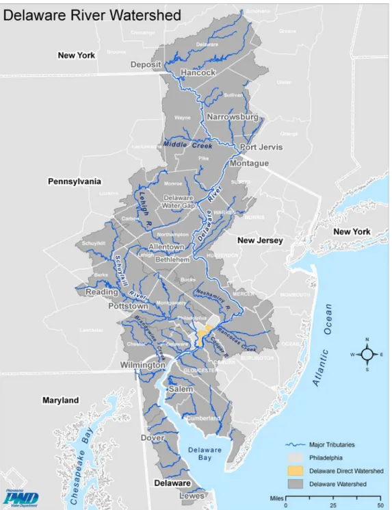
The Delaware River originates on the western slopes of New York State's Catskill
Mountains and stretches through four states and 42 counties before meeting the Atlantic Ocean at the Delaware Bay (Figure 2.1). Approximately 100 miles upstream from the Delaware Bay, the river passes through the fifth-largest metropolitan area in the nation—the heavily developed Philadelphia area. It is along this urban and
industrialized corridor that the Delaware Direct Watershed is located. The land area of the watershed totals approximately 35 square miles and includes roughly 25% of the entire city of Philadelphia (135 square miles). As the Delaware River enters the
Philadelphia metropolitan area, it is fed by several creeks and streams, each with its own drainage area, or watershed. As the river flows through the most developed portion of land along this course, the natural surface features that once helped to drain the watershed have been replaced with underground sewers. The Delaware Direct Watershed, located adjacent to and along 21 linear miles of riverbank in Philadelphia, drains directly into the Delaware River through the City’s combined sewer system, by overland flow and via private infrastructure. At the southern end of the watershed, the Delaware meets its largest tributary, the Schuylkill River. From here, the river flows past Wilmington, Delaware, and eventually completes its 330-mile course to the Atlantic Ocean at the mouth of the Delaware Bay near Cape Henlopen, Delaware. 1
While it is important to frame the watershed as part of the larger Delaware River Basin (DRB), the Delaware Direct is mostly unlike any other part of the DRB. As the city developed, the surface streams that historically drained the land were incorporated into a network of drainage pipes to mitigate health hazards. Ultimately, the piped streams became part of what is called a combined sewer system: a system in which rainwater, along with household and commercial waste, is collected in a single pipe and directed to a water treatment facility or nearby creeks and rivers during rain events. Presently, the watershed is densely populated and largely made up of developed land and impervious surface.
The imperviousness of land area and the hidden streams have created a unique watershed with very specific characteristics and management challenges. In response, the Philadelphia Water Department (PWD) has recently submitted the Green City, Clean Waters Plan to the Pennsylvania Department of Environmental Protection (DEP) and to the U.S. Environmental Protection Agency (EPA). The plan details how the City of Philadelphia will invest $2 billion over the next 25 years with a proactive and
sustainable approach to protecting the city’s water resources. More specific information pertaining to the water resources in the Delaware Direct Watershed and the challenges
associated with its protection and management can be found in Chapter 5, the Water Resources section of this document.
Figure 2.1 – Delaware River Watershed within the Delaware River Basin Source: PWD
2.1 Watershed Characteristics
The Delaware Direct Watershed is located within the Mid-Atlantic Coastal Plain. This flat, sandy region was formed when Triassic-period deposits were eroded and
the Delaware River drainage basin are the determining factor in the sediment-transport characteristics of the river and its tributaries. The soils, in turn, are determined by the geology and weathering processes of the rock material. Approximately 95% of the Delaware Direct Watershed is comprised of soils classified as Urban Land because they have been highly modified through development. More detailed information regarding the geomorphology of this area can be found in the Chapter 4, the Land Resources section of this document.
2.1a – Land Use
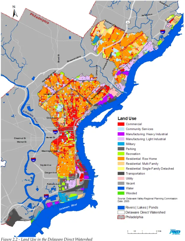
According to the land use map, Figure 2.2, the most prevalent land use in the watershed is residential property, totaling nearly 40%. Most of this is comprised of row homes, a common feature of Philadelphia neighborhoods. Other residential multi-family and single-family housing also contribute to this large proportion. Manufacturing and commercial property make up roughly 23% of the land use within the watershed. Not surprisingly, most of the industrial and manufacturing land is concentrated in large parcels along the riverfront. While there are many smaller commercial properties interspersed between mostly residential areas, much of the commercial property is concentrated in Center City Philadelphia and extends north on Broad Street toward Temple University. The Port Authority’s pier facilities along the riverfront also present a high concentration of commercial land use. Transportation features, such as railways and roadways occupy approximately 10% of the watershed’s land. Another notable feature is the amount of land used by parking, totaling 7.65%of the watershed. Wooded land is one of the least represented features in this urban watershed.
Figure 2.2 - Land Use in the Delaware Direct Watershed Source: PWD
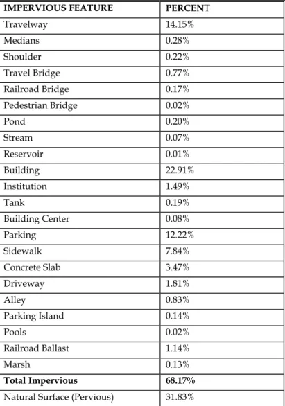
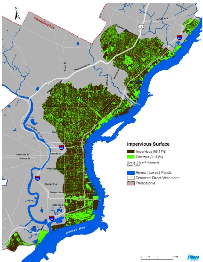
The urban nature of the watershed can be seen in the amount of impervious surface cover present, totaling 68% of the land area. Buildings and automobile-related features, such as roadways and parking lots make up the majority of impervious surface. Table 2.1 shows the impervious surface categories and their percentage of occurrence in the watershed, while Figure 2.3 shows these impervious features on a Watershed Base Map.
Many planning initiatives in the watershed seek to reduce the amount of impervious hardscape features to help manage stormwater volumes while adding green space for public use and to enhance neighborhood aesthetics.
Table 2.1 – Impervious Features in the Delaware Direct Watershed
IMPERVIOUS FEATURE PERCENT
Travelway 14.15% Medians 0.28% Shoulder 0.22% Travel Bridge 0.77% Railroad Bridge 0.17% Pedestrian Bridge 0.02% Pond 0.20% Stream 0.07% Reservoir 0.01% Building 22.91% Institution 1.49% Tank 0.19% Building Center 0.08% Parking 12.22% Sidewalk 7.84% Concrete Slab 3.47% Driveway 1.81% Alley 0.83% Parking Island 0.14% Pools 0.02% Railroad Ballast 1.14% Marsh 0.13% Total Impervious 68.17%
Figure 2.3 - Impervious Surface in the Delaware Direct Watershed
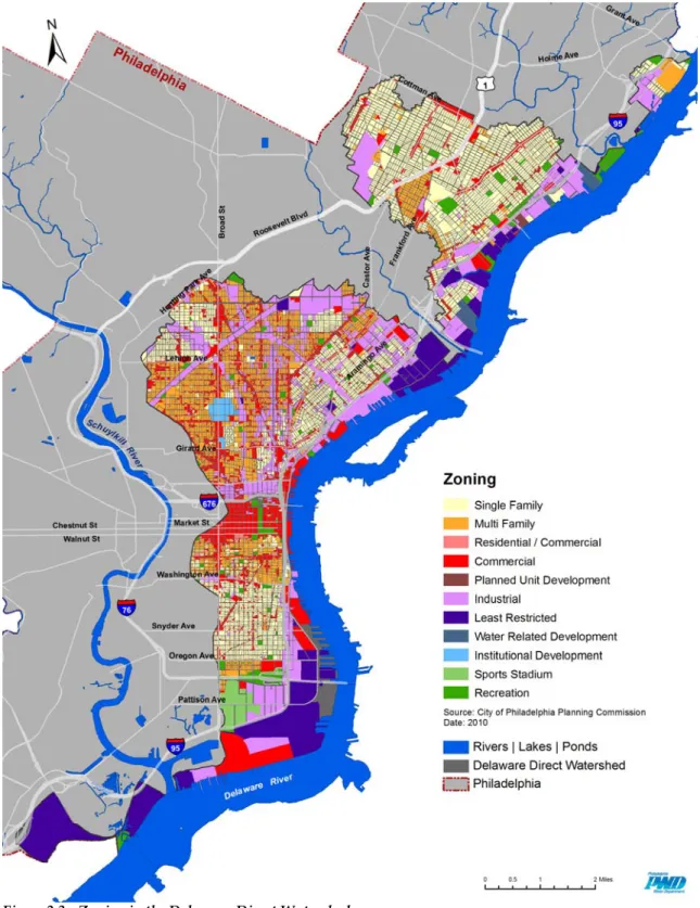
2.1b - Zoning and Ownership Zoning
Zoning represents the types of development that are encouraged by municipalities and that can set restrictions on various land uses. The aim of zoning is to protect the safety, health and well-being of the public by imposing regulations on building construction and development types. Philadelphia adopted its first zoning code in 1933, and the code was originally developed to prevent industrial centers from degrading residential communities.
Many additions and changes have been made to the zoning code since it was first adopted, with a comprehensive revision and citywide zoning remapping undertaken in the early- and mid-1960s. Today, the Philadelphia zoning code is again undergoing a transformation because of the many issues that have occurred as a result of past regulations. The present code is considered by many to be overly long, confusing and outdated. Therefore, the Zoning Code Commission was approved by voters in 2007 and established to create an updated zoning code to improve the quality of design and development city-wide. The Figure 2.3 displays a map of the Delaware Direct as it is currently zoned in the year 2010. 2
Figure 2.3 - Zoning in the Delaware Direct Watershed
Source: PWD
Unclear regulations made enforcement of the code difficult. The new zoning code will be easier for the general public and development community to understand and will be created to support approaches to sustainable growth and changing technologies while
yielding predictable development results. Reinforcing the character of neighborhoods is in the forefront of the zoning code revision.
The new code is currently in draft form and has been released for public review. The mission as stated in Philadelphia’s New Zoning Code Consolidated Draft (Sept. 2010) is as follows:
• Hold consistency with the City’s comprehensive plan
• Ensure properties and open space have enough light, air, privacy and access
• Maintain neighborhood character
• Conserve natural and historical areas and sites
• Foster the City’s sustainability goals in renewable energy, conservation of both energy and water, and availability of urban food gardens
• Create development plans that are fair with equal distribution across the City
• Safe transportation for all (walk, car, bike, rollerblade, public transit, etc.) For the most up to date information regarding the zoning code, please visit Zoning Matters and the Philadelphia City Planning Commission websites.
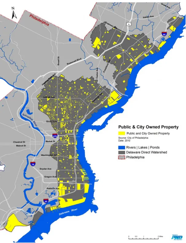
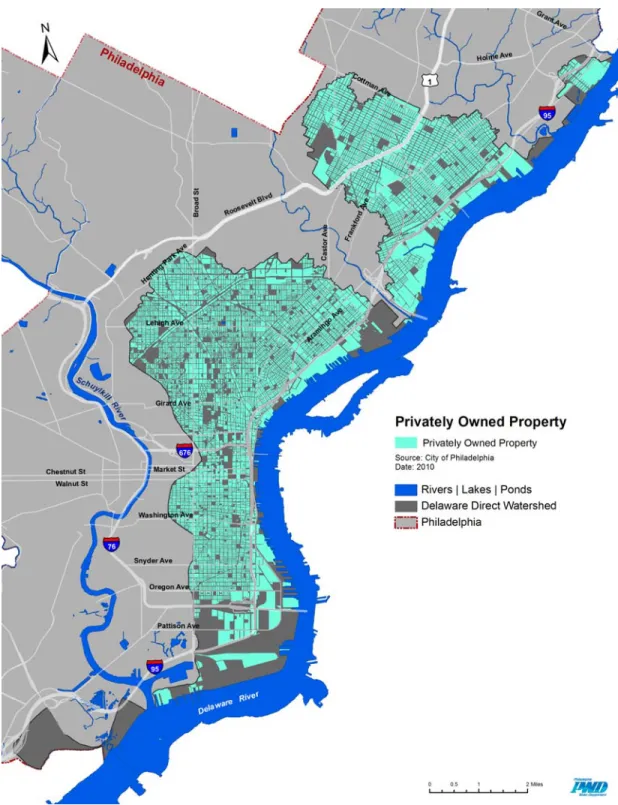
Land Ownership
Public land makes up approximately 25% of the land parcels in the watershed, while privately owned land occupies 75%. Vacant land makes up 12.65 % percent of the total parcel area. A high concentration of vacant land in the watershed is located along the riverfront at former industrial and commercial sites. Figures 2.4, 2.5 and 2.6 illustrate land ownership in the watershed.
Figure 2.4 – Public and City Owned Property in the Delaware Direct Watershed
Figure 2.5– Privately Owned Property in the Delaware Direct Watershed
Figure 2.6 – Vacant Property in the Delaware Direct Watershed
Source: PWD
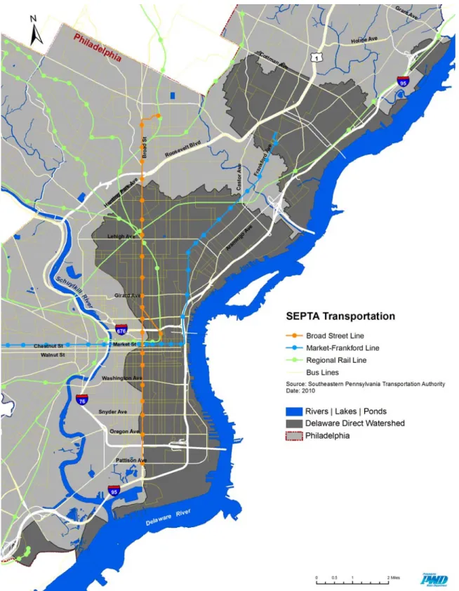
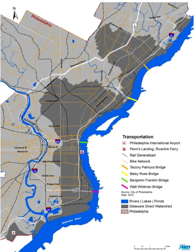
2.1c - Transportation Facilities
A fully developed transportation network connects residents and commuters to the various resources within the watershed. As part of urban Philadelphia, the watershed is also very accessible by car. From small neighborhood streets to arterial roads and interstates, roadways make up nearly 15% of the watershed’s land area. Also, four large
bridges connect the watershed to neighboring New Jersey. Public transportation is served by bus, trolley, subway, elevated rail, regional rail and ferry service. Totaling 8% of the surface area in the watershed, sidewalks provide substantial pedestrian
infrastructure. The Delaware Direct is home to both the Philadelphia International Airport (PHL) and the headquarters of Southeastern Pennsylvania Transportation Authority (SEPTA). Figure 2.7 shows SEPTA infrastructure in the watershed. SEPTA bus routes run throughout the watershed. The Market-Frankford Line, the Broad Street Line, and the Ridge Spur trains serve the watershed through thirty-one stations. All regional rail lines can be accessed by Market East Station. Figure 2.8 depicts transportation infrastructure including the airport, bridges, the River Link Ferry to Camden, and bike routes. In general, the watershed is relatively bike-friendly. There are fifty-one linear miles of bike lanes in the watershed. Combined with other bike-friendly routes, nearly one-quarter of the watershed is considered bike-able. For more information regarding public transportation services, visit Southeastern Pennsylvania Transportation
Authority (SEPTA) for schedules and fares or the River Link for information regarding the ferry system.
Figure 2.7 – SEPTA Transportation in the Delaware Direct Watershed
Figure 2.8 – Transportation in the Delaware Direct Watershed
2.2 – Parks, Recreation and Open Space
The Delaware Direct Watershed contains a total of 45 parks covering two square miles, or 3.4% of the land area. There are 108 recreation centers that serve the surrounding communities’ recreational needs. A recent assessment by Philadelphia Parks and Recreation (PP&R) identified many facilities in need of maintenance and upgrades. PP&R is proposing safety improvements for play areas in parkland at Penn Treaty Park. The project includes removing aging, unsafe and outdated equipment and replacing it with new ADA-accessible play equipment and safety surfaces. Proposed improvements to existing trails and the development of new trails within the Fairmount Park system will increase accessibility and recreational opportunities. This project includes
improvements to trails along the Delaware, Tacony and Poquessing creeks. These trails allow Philadelphians to bike, walk, rollerblade and run through these parks, enjoying the waterways, wildlife and vegetation of Fairmount Park. More than a dozen boat launches and marinas along the riverfront also provide opportunities for water-based recreation. Figure 2.9 shows recreation resources within the project area.
Figure 2.9 – Recreation in the Delaware Direct Watershed
2.2a - Waterfront Characteristics
The eastern boundary of the Delaware Direct Watershed is in fact the Delaware River including 21 miles of riverfront. Historically, the riverfront was developed for industrial use, which limited public access to the water. These large facilities, both active and abandoned, are indeed a major feature of the waterfront. The presence of Interstate 95 also poses challenges in reconnecting residents to the Delaware riverfront.
Redevelopment efforts are varied but have lacked a unified vision. The Navy Yard and the Arsenal Business Center present examples of successful redevelopment of two former U.S. military installations that both respect their histories and create new economic opportunities in the watershed. Casino development is one of the most
contentious issues affecting the riverfront within the watershed. The Sugarhouse Casino, situated on the 22-acre site of a former sugar refinery, is located in the Fishtown
neighborhood. A second casino has been given a license to develop a 16-acre parcel at Columbus Boulevard and Tasker Avenue in South Philadelphia, although the license was recently revoked due to the developer’s lack of progress in building the casino. Opponents view the development of the waterfront for the use of casinos as a poor use of riverfront property, and many residents of neighboring communities are wary of the changes that casinos may bring.
Several waterfront parks exist along the Delaware River including Penn Treaty Park in Fishtown, Pulaski Park in Port Richmond, and Pleasant Hill Park in East Torresdale. Recent projects, such as Washington Avenue Green, have transformed former industrial sites into public open space, incorporating principles of stormwater management, riparian plantings and innovative approaches to public art and green design. Race Street Pier, at the foot of the Ben Franklin Bridge, will similarly use a former industrial site to provide much-needed civic open space along the riverfront. The groundbreaking for this project took place on November 9, 2010. Furthermore, The Delaware River City
Corporation (DRCC) has developed the plan for Lardner’s Point Park, a 4.5-acre park adjacent to the Tacony-Palmyra Bridge in Northeast Philadelphia.
The DRCC is also heading the development of two portions of the Delaware Trail: the K&T and the Baxter Trail. These trails are to be connected to the greater East Coast Greenway, a trail system that stretches from Florida to Maine. Also in place are plans for a Delaware Riverfront Trail that is to be incorporated into a recently adopted Central Delaware Riverfront zoning overlay (Bill No. 090170). The zoning overlay proposes that all land within 100 feet of the waterfront edge between Allegheny and Oregon avenues be utilized in the development of a publicly accessible, multi-use trail.
Another recent development in regard to recreation and open-space improvements is the creation of the Delaware River Waterfront Corporation (DRWC), a nonprofit organization seeking to transform the Central Delaware into a vibrant and easily accessible destination. The organization has already begun implementing
recommendations from several ongoing planning efforts, primarily those found in the Civic Vision Plan and the Action Plan for the Central Delaware. Both of these plans recognize the need for sustainable green space and its positive impact on air quality, public health and stormwater management.
Waterfront Assessments
The Philadelphia Water Department conducted visual assessments of the Delaware River waterfront over two successive days in June, 2007. Due to limited on-foot access to the riverbank, these assessments were conducted by boat, starting at the Darby Creek confluence and continuing upstream to the Poquessing Creek confluence. Overall, very little of the waterfront exists in a natural state, and it exhibits minimal vegetative coverage and tree canopy. Eel Grass (Vallisneria americana) and spadderdock (Nuphar luteum) are the most common types of vegetation noted in these assessments. Bird species, such as cormorants, laughing gulls, herring gulls, seagulls, Canada geese, mallard duck, blue heron and osprey were observed during the assessments.
Abandoned piers, vehicles and other structures are also featured along most segments. Full text of these assessments can be found in Appendix A of this document and a virtual tour in Google Earth is available online at
http://www.phillywatersheds.org/your_watershed/delaware/virtual_tours
2.3 - Socioeconomic Characteristics
The total population of the Delaware Direct Watershed is 501,998 and represents
approximately one-third of the entire population of Philadelphia (1,526,006, according to the U.S. Bureau of the Census data from 2010). Most of the Delaware Direct Watershed is a patchwork of city neighborhoods. There are at least 72 neighborhoods within the project area, as seen on the watershed base map, Figure 1.1. Many neighborhoods have their own initiatives and projects that are helping to improve quality of life and to create sustainable communities. The Table 2.2 lists neighborhoods within the watershed and references civic organizations within those neighborhoods when available.
Table 2.2 – Neighborhood Civic Organizations in the Delaware Direct Watershed Neighborhood Civic Association
Allegheny West Allegheny West Foundation
Bella Vista Bella Vista United Civic Association
Bridesburg Bridesburg Town and Civic Association
Burholme Burholme Community and Town Watch Civic Association
Cabot
Callowhill Chinatown North Callowhill Neighbor Association
Castor Gardens Castor Gardens Civic Association
Cecil B Moore
Chinatown Philadelphia Chinatown Development Corporation
Dickinson Narrows Dickinson Narrows Civic Association
East Kensington East Kensington Neighbors Association
East Passyunk East Passyunk Crossing Civic Association and Town Watch
East Poplar East Poplar Community Association
East Tioga
East Torresdale East Torresdale Civic Association
Fairhill
Fishtown Fishtown Neighbors Association
Forgotten Blocks
Frankford Frankford Civic Association Frankford Valley Frankford Valley Civic Association
Greenwich Lovely
Harrowgate
Hawthorne Hawthorne Empowerment Coalition
Holmesburg Holmesburg Civic Association
Hunting Park Hunting Park Civic Association/ Ayuda Community Center
Juniata Park Juniata Park Civic Association
Kensington Kensington Neighbors United Civic Association
Kensington South Kensington South CDC
Lawndale
Ludlow
Market East
Mayfair Mayfair Civic Association
Navy Yard None found
New Kensington New Kensington CDC
Newbold Newbold Civic Association
Norris Square Norris Square Civic Association
North Central
North Delaware
Northern Liberties Northern Liberties Neighbor Association
Northwood Northwood Civic Association
Old City Old City Civic Association
Olde Kensington Olde Kensington Neighbors Association
Oxford Circle
Passyunk Square Passyunk Square Civic Association
Pennsport Pennsport Civic Association
Point Breeze Point Breeze Civic Association
Port Richmond North Olde Richmond Civic Association
Port Richmond South Olde Richmond Civic Association
Queen Village Queen Village Neighbors Association
Richmond Olde Richmond Civic Association
Rittenhouse Sq. Friends of Rittenhouse Square
Society Hill Society Hill Civic Association
South Of South SOSNA (South of South Neighborhood Association)
South Philadelphia South Philadelphia Communities Civic Association
Spring Garden Spring Garden Civic Association
St Edwards/Hartranft
St. Hugh
Strawberry Mansion
Summerdale Friends of Summerdale Civic Association
Tacony Tacony Civic Association
Temple Area
Tioga
Upper Northwood Northwood Civic Association
Washington Square West Washington Square West Civic Association
West Fairhill West Fairhill Community Association
West Poplar West Poplar NAC (Neighborhood Advisory Committee)
Whitman Whitman Council Inc
Wissinoming Wissinoming Civic Association
Yorktown Yorktown Community Development
2.3a - Population Density
Overall, the population density of the Delaware Direct is high, around 14,764 persons per square mile. However, the way in which population is distributed varies. Some areas of the watershed show great contrast in terms of population density, especially along the Delaware River waterfront and in Center City. As illustrated in Figure 2.10, several areas that depict zero population are adjacent to those with greater than 50 persons per acre. While this is sometimes indicative of vacant property, it is also evidence of a mix of commercial and residential development throughout the watershed. The southern end of the watershed is home to large industrial and
commercial facilities that contrast with the densely populated neighborhoods of South Philadelphia. The central portion of the watershed is comprised of the central business district and its surrounding neighborhoods. This area also shows high contrast in population density; for example, when a multi-story commercial property is adjacent to a multi-story residential property. The northern and northeastern parts of the watershed exhibit more even population distribution and relatively high population density. These areas are predominantly residential city neighborhoods, with the exception of Temple University Main Campus in North Philadelphia and the other employment nodes of Northeast Philadelphia.
Figure 2.10 – Population Density in the Delaware Direct Watershed
2.3b - Demographic and Socioeconomic Factors
The Delaware Direct contains a broad range of communities that differ in racial and ethnic make-up, income level and age. The watershed in its entirety is racially and ethnically diverse, yet there are a number of demographically distinct communities within. As a whole, the watershed contains 56% white residents and 44% non-white residents, according to the 2000 U.S. Census. The watershed does differ from the city as a whole, which contains 44% white residents and 56% non-white residents.
The population of white residents is concentrated primarily in the northern reach of the watershed, where the easternmost communities of Tacony, Mayfair and Wissinoming are almost entirely white and display very low counts of non-white minority residents. Neighborhoods to the west of this area, such as Oxford Circle and Castor Gardens, contain a more racially-mixed population. The majority of neighborhoods along the Delaware itself, such as Port Richmond, Fishtown and Old City, are predominantly white. South Philadelphia contains pockets of minority residents but the southernmost portion consists of mainly white residents.
Neighborhoods found farther inland contain much larger numbers of minority
residents, yet also show signs of racial segregation. The majority of the central-western portion of the watershed, including the neighborhoods of North Philadelphia, North Central Philadelphia, Tioga, East Tioga, Allegheny West, Strawberry Mansion, Cecil B. Moore, Cabot and Yorktown is predominantly African-American, with each of these neighborhoods containing 75% or more black residents.
Similarly, Hispanic residents are clustered primarily in the neighborhoods to the immediate east of these areas, such as St. Hugh, Fairhill, West Kensington and Norris Square. These neighborhoods are made up of 75% or more Hispanic residents. The primary contingent of Asian residents is found in Chinatown near Center City
Philadelphia and in the central portion of South Philadelphia. Figure 2.11 provides four maps depicting minority population concentrations within the project area.
Figure 2.11 – Minority Population Distribution within the Delaware Direct Watershed Source: PWD
While the majority of the watershed contains predominantly residents who are native U.S. citizens, there are certain portions where higher numbers of foreign-born residents
are found. There are three main pockets of foreign-born residents, one in the
northernmost portion of the watershed, in the vicinity of the neighborhoods of Oxford Circle and Castor Gardens, the next in the highly Hispanic portion of the watershed, namely the neighborhoods of St. Hugh, Fairhill, West Kensington and Norris Square and the third covering a large portion of Center City and central South Philadelphia, those areas which are most highly populated by Asian residents. Small pockets of immigrant populations are found outside of this area. Figure 2.12 shows the distribution of foreign born residents of the watershed.
Figure 2.12 – Foreign Born Population in the Delaware Direct Watershed Source: PWD
The communities within the watershed also differ in age. Communities in the northernmost and southernmost portions of the watershed have higher numbers of residents over 65 years old, whereas the neighborhoods throughout North Philadelphia
and the central portion of the watershed have greater residents under the age of 18. Center City contains the lowest numbers of residents under age 18. Figure 2.13 shows this characterization of age distribution in the watershed.
Figure 2.13 – Percentage of Population under 18 and over 65 Years of Age in the Delaware Direct Watershed Source: PWD
While the median 2000 income of households within the watershed ($29,164) is nearly equal to that of the city ($30,517), this factor varies greatly by neighborhood as well. The highest incomes are found in the Old City portion of the watershed, where the median reaches as high as $87,027. Moderately high incomes are also found in the northernmost neighborhoods and throughout Center City. On the other hand, the lowest incomes are found in the central portion of the watershed in the North Philadelphia neighborhoods, in those same neighborhoods which are predominantly black and Hispanic. The median household income in these areas ranges from $7,500 to $25,000, significantly lower than the city median.
2.3c - Source of Employment
Employment is varied and spread throughout the watershed. The largest employer is the School District of Philadelphia, whose headquarters is on North Broad Street in the Callowhill neighborhood. PNC Bank, SEPTA, Thomas Jefferson Hospital, Macy’s, Comcast and Temple University all have their main facilities firmly within the
watershed as well, providing large numbers of jobs in these specific locations, as well as contributing throughout the watershed in satellite locations. Between large corporations and the significant contribution of smaller employers, many types of employees work in the Delaware Direct Watershed.
Within the watershed, there are a few areas of employment concentration that can be called nodes of employment. These are zones with a high concentration of jobs and economic activity, creating a large-scale impact on the watershed in various ways. These regions emerge on both the population density map and the land use map with their heavy concentration of zero population and singular land use, respectively. The Delaware Direct Employment Nodes map, Figure 2.14, plots these facilities by address to give a general picture of their locations. The southernmost node is the Philadelphia International Airport (PHL). It is one of the largest economic engines in Pennsylvania, generating an estimated $14.2 billion in spending and accounting for more than 141,000 jobs within the region.3 To the north, the Philadelphia Naval Yard is an example of adaptive reuse of a historic military facility. This waterfront development houses more than 80 companies and employs approximately 7,500 people in retail, distribution facilities and research laboratories.4 Another employment node of the watershed is found along Christopher Columbus Boulevard, which parallels the riverfront pier facilities operated by the Philadelphia Port Authority. Columbus Boulevard is a hub for large retail chains, such as Home Depot, Lowe’s, IKEA, Target, Wal-Mart and Best Buy, as well as many other smaller retailers. In terms of use, this retail corridor is contrasted by the adjacent shipping, warehouse and distribution facilities operated by the
Philadelphia Port Authority sited along the waterfront. The Port of Philadelphia is one of only 14 ports in the United States permitted to handle the U.S. military cargoes headed for international destinations.5
3
Philadelphia International Airport, Feb 5 2011 <www.phl.org>
4
Philadelphia Navy Yard, Feb 5 2011 <www.navyyard.org>
5
Figure 2.14 – Delaware Direct Employment Nodes in the Delaware Direct Watershed Source: PWD
The Central Business District is the commercial heart of Center City Philadelphia, an area bound by the Delaware River to the east and the Schuylkill River to the west. The
north and south boundaries are marked roughly by Vine Street to the north and South Street to the south. Because the boundaries of the Delaware Direct Watershed are determined by drainage characteristics, the western boundary of the watershed is approximately located at Broad Street, just east of City Hall, and creates an irregular edge not confined by city blocks. Within the watershed, this node of employment contains its largest concentration of jobs as well as high diversity in employment type. The city’s largest employer, the School District, is within this node, as is Jefferson Hospital. Much of the region’s historic tourism is within this node and is home to Independence National Historical Park, the Liberty Bell and other significant historic sites. The Central Philadelphia Development Corporation(CPDC) is a rich source of economic and employment data for the city and this node in particular. When
referencing this information, keep in mind that the watershed boundaries do not always include all of the areas referenced in CPDC reporting.
In North Philadelphia, Temple University is a center for employment in education and health services. Temple is the 27th-largest university in the United States, and Temple University Hospital is a major teaching center. Northeast Philadelphia contains three nodes that contribute significantly to the employment characteristics of the watershed. The economy of this area evolved from farming to industry in the 19th century, and factories and mills sprang up along the Delaware River waterfront and the creeks that drained to the river. The Aramingo Retail area covers approximately seven blocks of Aramingo Avenue between Wheatsheaf Lane and Allegheny Avenue. This
concentration of big-box stores, grocery stores and other smaller retail establishments has been designated a Business Improvement District. The redevelopment efforts have transformed vacant industrial sites into jobs and services for the surrounding
neighborhoods and beyond. Tioga Marine Terminal, owned by the Port Authority of Philadelphia, occupies 116 acres along the Delaware River at Tioga Street. This facility handles mostly produce and container shipping. The northernmost node of significant employment is the Frankford Arsenal. A part of the U.S. Arsenal System for
manufacturing military munitions, this site has been redeveloped as an 86-acre business campus, Arsenal Business Center. The northernmost part of the site was assumed by the Pennsylvania Fish and Boat Commission for use as a boat launch access ramp and fishing site on the Delaware River. The southernmost part is currently being used as a light-industrial and office park.
All these areas of employment concentration have been developed over several centuries and most are the product of the heavy industrialization that occurred at the turn of the 19th century. The needs of the growing city were often met at the expense of our region’s natural resources. However, current attitudes toward sustainability seek to mitigate some of the challenges created by development on this scale. As our economy shifts away from industrial-based activities, abandoned and underused facilities become redevelopment opportunities. The high profile that comes with such concentrations of employment and economic activity provides great opportunities for aligning market forces with public sentiment. Hopefully, these economic engines will become agents of change, providing access to services as well as access to the waterfront and public green space.