1.0 EXECUTIVE SUMMARY 1
2.0 INTRODUCTION OF THE PROJECT/ BACKGROUND INFORMATION 3
(i) IDENTIFICATION OF PROJECT & PROJECT PROPONENT 3
(ii) BRIEF DESCRIPTION OF NATURE OF THE PROJECT 4
(iii) NEED FOR THE PROJECT & ITS IMPORTANCE TO THE COUNTRY /REGION
4
(iv) DEMAND-SUPPLY GAP 4
(v) IMPORTS VS. INDIGENOUS PRODUCTION 4
(vi) EXPORT POSSIBILITY 4
(vii) DOMESTIC/EXPORT MARKETS 4
(viii) EMPLOYMENT GENERATION (DIRECT AND INDIRECT) DUE TO THE PROJECT
5
3.0 PROJECT DESCRIPTION 5
(i) TYPE OF PROJECT INCLUDING INTERLINKED AND INDEPENDENT PROJECTS, IF ANY
5
(ii) LOCATION (MAP SHOWING GENERAL LOCATION, SPECIFIC LOCATION, AND PROJECT BOUNDARY & PROJECT SITE LAYOUT) WITH COORDINATES
5
(iii) DETAILS OF ALTERNATIVE SITE CONSIDERED 7
(iv) SIZE OR MAGNITUDE OF OPERATION 7
(v) PROJECT DESCRIPTION WITH PROCESS DETAILS 8
(vi) RAW MATERIAL REQUIRED ALONG WITH ESTIMATED
QUANTITY, LIKELY SOURCE, MARKETING AREA OF FINAL PRODUCTS, MODE OF TRANSPORT OF RAW MATERIAL AND FINISHED PRODUCT
9
(vii) RESOURCES OPTIMIZATION/ RECYCLING AND REUSE ENVISAGED IN THE PROJECT, IF ANY, SHOULD BE BRIEFLY OUTLINED
9
(viii) AVAILABILITY OF WATER ITS SOURCE, ENERGY /POWER REQUIREMENT AND SOURCE
9
(ix) QUANTITY OF WASTE TO BE GENERATED (LIQUID AND SOLID) AND SCHEME FOR THEIR MANAGEMENT/DISPOSAL
9
4.0 SITE ANALYSIS 9
(i) CONNECTIVITY 9
(ii) LAND FORM, LAND USE AND LAND OWNERSHIP 10
(iii) TOPOGRAPHYALONG WITH MAP 10
(iv) EXISTING LAND USE PATTERN {AGRICULTURE,
NON-AGRICULTURE, FOREST, WATER BODIES (INCLUDING AREA UNDER CRZ)}, SHORTEST DISTANCES FROM THE PERIPHERY OF THE PROJECT TO PERIPHERY OF THE FORESTS, NATIONAL PARK, WILD LIFE SANCTUARY, ECO SENSITIVE AREAS, WATER BODIES (DISTANCE FROM THE HFL OF THE RIVER), CRZ. IN CASE OF
(v) EXISTING INFRASTRUCTURE 14
(vi) SOIL CLASSIFICATION 14
(vii) CLIMATIC DATA FROM SECONDARY SOURCES 14
(viii) SOCIAL INFRASTRUCTURE AVAILABLE 14
5.0 PLANNING BRIEF 14
(i) PLANNING CONCEPT (TYPE OF INDUSTRIES, FACILITIES, AND
TRANSPORTATION ETC.) TOWN AND COUNTRY
PLANNING/DEVELOPMENT AUTHORITY CLASSIFICATION
14
(ii) POPULATION PROJECTION 15
(iii) LAND USE PLANNING 15
(iv) ASSESSMENT OF INFRASTRUCTURE DEMAND (PHYSICAL & SOCIAL)
15
(v) AMENITIES/FACILITIES 15
6.0 PROPOSED INFRASTRUCTURE 15
(i) INDUSTRIAL AREA (PROCESSING AREA) 15
(ii) RESIDENTIAL AREA (NON PROCESSING AREA) 15
(iii) GREEN BELT DEVELOPMENT 15
(iv) SOCIAL INFRASTRUCTURE 15
(v) CONNECTIVITY 15
(vi) DRINKING WATER MANAGEMENT (SOURCE & SUPPLY OF WATER)
16
(vii) SEWERAGE SYSTEM 16
(viii) INDUSTRIAL WASTE MANAGEMENT 16
(ix) SOLID WASTE MANAGEMENT 16
(x) POWER REQUIREMENT & SUPPLY/SOURCE 16
7.0 REHABILITATION AND RESETTLEMENT (R & R) PLAN 16
(i) POLICY TO BE ADOPTED (CENTRAL/STATE)IN RESPECT OF THE PROJECT AFFECTED PERSONS INCLUDING HOME OUSTEES, LAND OUSTEES AND LANDLESS LABORERS (BRIEF OUTLINE TO BE GIVEN)
16
8.0 PROJECT SCHEDULE & COST ESTIMATES 16
(i) LIKELY DATE OF START OF CONSTRUCTION AND LIKELY DATE OF COMPLETION (TIME SCHEDULE FOR THE PROJECT TO BE GIVEN)
16
(ii) ESTIMATED PROJECT COST ALONG WITH ANALYSIS IN TERMS OF ECONOMIC VIABILITY OF THE PROJECT
16
9.0 ANALYSIS OF PROPOSAL 16
(i) FINANCIAL AND SOCIAL BENEFITS WITH SPECIAL EMPHASIS ON THE BENEFIT TO THE LOCAL PEOPLE INCLUDING TRIBAL POPULATION IF ANY
LIST OF TABLES
TABLE NO.
NAME OF TABLE
PAGE NO.
1.
BRIEF OF THE PROJECT1
2.
LOCATION AND AREA OF THE PROJECT7
3.
YEAWISE PRODUCTION DETAILS8
PRE-FEASIBILITY REPORT
1.0 EXECUTIVE SUMMARY
Table – 1 Brief of the Project
S. No. Particulars Details
A. Location Details
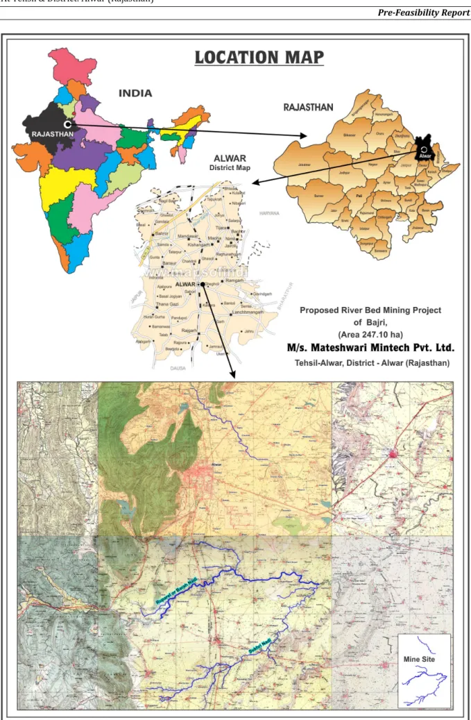
1. Village(s) Ahirbas, Indragarh, Ulahedi, Kairwara, Kairwari, Kairwa Jat, Kairwawal, Kesarpur, Khedli Saiyad, Khedli Pichnaut, Kharkhara, Gujuki, Gajika, Ghegholi, Ghatla, Chomu, Chhajurampura, Jatoli, Dhhakpuri, Dadar, Nangla Charan, Nangla Jogi, Nangli Sandh, Naithala, Nangal Jhida, Nangal Todiyar, Naharpura Kalan, Piladhaba, Bandipura, Barkhera, Burja, Bahadurpur Pattikatla, Badh Vilandi, Bichpuri, Modiya, Moreda, Mohabbatpur, Ratangarh, Roopbas, Haldina, Satana, Sumel, Salpur, Salpuri, Shanpur, Mahuwa Kala, Mahuwa Khurd, Dholaplash, Achalpuri, Roopbas, Bhandodi. 2. Tehsil Alwar 3. District Alwar 4. State Rajasthan 5. Latitude/Longitude 27°19'17.84"N to 27°39'13.10"N 76°31'42.26"E to 76°46'28.40"E
6. Toposheet No 54A/6, 54A/7, 54A/10, 54A/11, 54A/12, 54A/14 & 54A/15
B. Lease Area Details
7. Lease area 247.10 ha
8. Type of land Govt. Land (Gair Mumkin Nadi & Nallah)
C. Cost Details
9. Total Project Cost Rs 1 Crores/-
10. Cost for Environmental Protection Measures
Capital cost – Rs. 4 Lacs/-
Recurring Cost per annum : Rs. 2.5 Lacs per annum/-
D. Requirements of The Project
11. Water Requirement 30 KLD which will be required for (spraying, plantation and drinking) sourced from nearby villages.
12. Power Requirement Electric power is not required as mine will be operated in day hours only. The machinery will be diesel operated. 13. Man Power Requirement 340 (Direct Employment)
ENVIRONMENTAL MANAGEMENT PLAN
Guidelines for sustainable mining of minor mineral which lays down the parameters of riverbed mining, evolved by MoEF, New Delhi vide their letter no. Z-1102/3/2009-IA.II (M) dated June 1st, 2010 will be followed. Also, the State Govt. Policy Notification GSR 27 dated 21st June, 2012
(Annexure-III) will be followed. Geological Survey of India, GSI have also issued guidelines relating to river bed guidelines
S. No. PARTICULARS DETAILS
1. Air Quality
Management
Water sprinkling will be done during loading, transportation over approach roads
Regular maintenance of machinery will be carried out.
Overloading will be prevented.
Trucks will be covered by tarpaulin covers
It will be ensured that all transportation vehicles carry a valid PUC certificate.
Plantation will be carried out at the approach road, river bank and vicinity area.
Periodic air quality monitoring will be done and adequate measures will be taken.
2.
Water Quality Management
Waste water will not be generated during mining operations as it involves only collection of bajri.
Ground Water will not be intersected during mining activities.
Mining will be done well above the water table, 1 m above sub terranean water table; therefore, no adverse impact on surface water regime will be there.
No waste water will be generated from the mining activities.
Toilets will be made available near mine’s office away from the river.
Septic tanks and soak pits will be provided for the disposal of domestic/toilet waste
3. Noise Quality
Management
Sources of noise will be during operation of excavators and transport vehicles. For this proper maintenance will be done at regular intervals.
Oiling and greasing at regular interval will be done.
S. No. PARTICULARS DETAILS
vehicles.
Minimum use of horns and speed limit of 10 km/hr in the village area.
Plantation will be carried out at the sides of approach road, river bank and vicinity area
4 Solid Waste
Management
Waste will not be generated in the mining activities as the project involves collection of Bajri.
There is no toxic element present in the mineral.
5 Plantation
Plantation will be carried out along the approach road, river banks and at all strategic points in the vicinity area. Trees of adequate height will be planted.
Plantation will also be done outside the lease area in consultation with Gram Panchayats.
It is proposed that the plantation development will be carried out in the vicinity of river banks, along the approach roads, around Govt. buildings, schools. About 1500 trees will be planted per year. Trees of adequate height will be planted.
Species proposed for greenbelt development are Aam (Magnifera Indica), Jamun (Syzygium cumini), Arjun (Terminalia arjuna), Shahtoot
(Morus Alba), Neem (Azadiracta indica), Pipal (Ficus religiosa), Babool
(Acacia nilotica), Ber (Ziziphus mauritiana), etc. will be planted.
Other Fruit bearing species, native species and plants useful for local etc. will also be planted in consultation with Forest department.
6
Socio Economics
Measures
The laboures will be from nearby villages that are purely dependent upon such mining activities because they are not skilled in any other trade and vocation and are engaged in this same trade since long time.
2.0 INTRODUCTION OF THE PROJECT/ BACKGROUND INFORMATION (I) IDENTIFICATION OF PROJECT AND PROJECT PROPONENT
M/s Mateshwari Mintech Pvt. Ltd has proposed River Bed Mining Project of Bajri, Area 247.10 ha with Production Capacity 0.342 MTPA from Gair Mumkin Nadi & Nallah at Tehsil & District Alwar, Rajasthan.
Letter of Intent (LOI) for grant of mining lease for Bajri over an area of 247.10 ha has been issued by the Joint Secretary, Department of Mines,
Government of Rajasthan, vide letter no. P. 6 (4)/ Mine/ Group- 2/ 2014 dated 05.12.2014 for the period of five years.
(ii) BRIEF DESCRIPTION OF THE NATURE OF PROJECT
As per EIA Notification dated 14th September, 2006 amended as on date, the
project falls under S. No ‘1’ (Mining of Minerals), Project or Activity ‘1(a) - (3)’, Category “A”.
General condition is applicable as Sariska National Park is about 1.5 km in West direction from Lease area.
(iii) NEED FOR THE PROJECT & ITS IMPORTANCE TO THE COUNTRY AND OR REGION
The Bajri (Sand) is the main material required for construction activities. The mining activities will increase better employment opportunities. Average income level which is the indicator of socio-economic status of house hold is expected to increase and in turn it will uplift the economic standard.
The Bajri is deposited in the river bed during rainy season. To avoid risk of spreading the river and channelize the flow of river, the excavation of Bajri from river bed is necessary or we can say unavoidable as assessed and estimated by State Govt. Therefore the project will contribute in development of infrastructure and construction activities in the region as the Bajri is main raw material for the construction activities.
(iv) DEMAND – SUPPLY GAP
Considering the demand of Bajri and sufficient availability of the mineral in the area, it is necessary to have the mining project to sustain the uninterrupted supply of raw material for construction activities in the region & also to provide employment opportunities to nearby habitants.
(v) IMPORTS VS. INDIGENOUS PRODUCTION
The Bajri is a cheap raw material and available in abundance on river bed, therefore its import is not required.
(vi) EXPORT POSSIBILITY
There is no export possibility as these minerals are quite cheap and locally available in abundance. Also, export will entail huge logistics cost.
(vii) DOMESTIC/EXPORT MARKETS
(viii) EMPLOYMENT GENERATION (DIRECT AND INDIRECT) DUE TO THE PROJECT
The proposed production from this mining project in the area is about .34 million tonnes per year. The daily production will be about 1428 tonnes. Direct Employment to 340 persons will be required to meet the said production capacity and many persons will get indirect employment in transportation.
Due to movement of the men and transport vehicles, the satellite occupation in the form of small hotels, shops etc will boost economic activity in the area and many persons will get indirect employment in and around the area.
3.0 PROJECT DESCRIPTION
(i) Type of Project Including Interlinked And Independent Projects, If Any: No Interlinked Project(s) is there. This is a site specific single mining project.
(ii) Location (map showing general location, specific location, and project boundary & project site layout) with coordinates- Incorporated as Fig no. 1
TABLE 2
Location and Area of the Project
S. No. Particulars Details
A. Location Details
1. Village(s) Ahirbas, Indragarh, Ulahedi, Kairwara, Kairwari, Kairwa Jat, Kairwawal, Kesarpur, Khedli Saiyad, Khedli Pichnaut, Kharkhara, Gujuki, Gajika, Ghegholi, Ghatla, Chomu, Chhajurampura, Jatoli, Dhhakpuri, Dadar, Nangla Charan, Nangla Jogi, Nangli Sandh, Naithala, Nangal Jhida, Nangal Todiyar, Naharpura Kalan, Piladhaba, Bandipura, Barkhera, Burja, Bahadurpur Pattikatla, Badh Vilandi, Bichpuri, Modiya, Moreda, Mohabbatpur, Ratangarh, Roopbas, Haldina, Satana, Sumel, Salpur, Salpuri, Shanpur, Mahuwa Kala, Mahuwa Khurd, Dholaplash, Achalpuri, Roopbas, Bhandodi.
2. Tehsil Alwar
3. District Alwar
4. State Rajasthan
5. Latitude/Longitude 27°19'17.84"N to 27°39'13.10"N 76°31'42.26"E to 76°46'28.40"E
6. Toposheet No 54A/6, 54A/7, 54A/10, 54A/11, 54A/12, 54A/14 & 54A/15
(iii) Details of Alternate Sites Considered and the basis of selecting the proposed site, particularly the environmental considerations gone into should be highlighted.
This is a site specific mining project. Adequate quantity of Bajri reserves is available. Therefore, no Alternative Sites are examined.
(iv) Size or Magnitude of Operation
This is a Bajri mining project for collection of Bajri from Gair Mumkin Nadi & Nallah bed. The lease area is 247.10 ha and proposed production capacity is 0.342 million tonnes per annum. The collection will be done manually as well with excavators of low bucket capacity. No other operation is required.
TABLE 3
Year wise Production details Year Bajri (in million tonnes)
1st 0.342 2nd 0.342 3rd 0.342 4th 0.342 5th 0.342 Total 1.713
Source: Mining plan & progressive Mine Closure Plan
(v) Project Description with Process Detail (a schematic diagram/ flow chart showing the project layout, components of the project etc. should be given)
In respect of river bed mining, State Govt. Policy Notification GSR 27 was issued on 21st June, 2012. The MoEF, New Delhi has also issued a report of
working group in 2010 which also lays down the parameters of riverbed mining. Geological Survey of India, GSI have also issued guidelines relating to river bed guidelines. Mining will be done following all of the above mentioned guidelines.
Mining will be done for 3 metre thick strip at a time in the direction of river, to avoid ponding effect and maintaining the uniform surface.
No Mining will be done below water level and 45 m from any bridge, culvert, or any water works setup, if any etc.
No mining will be done within 10 m from the either side of river banks to maintain its river banks and for their protection.
Mining will proceed along the river in the direction from downstream to upstream in each block. No mining will be done across the river-nalla.
In order to make adequate replenishment, blocks will be mined in alternate year, so that one block is kept idle/ non working while the other block is being worked.
Every mining block will have clearly identified approach road/ entry points into the rivers-nalla and similarly the exit points.
No mining will be done on curves of the rivers-nalla to avoid the meandering effect.
(vi) Raw Material required Along With Estimated Quantity, Likely Source, Marketing Area of Final Products, Mode of Transport of Raw Material and Finished Product
This is a mining project with proposed production capacity of bajri 0.342 million TPA. No raw material will be required for proposed mining. The collected bajri will directly be sold in the open market. The Bajri produced from the area will be transported by trucks/dumpers to different destinations around the area.
(vii) Resources Optimization/ Recycling and Reuse Envisaged in the Project, if any, should be briefly Outlined.
No waste water will be generated from the mining operations.
There will no other product from the area, therefore reuse and recycling of the same is not envisaged.
(viii) Availability of Water Its Source, Energy /Power Requirement and Source
A. Water Requirement
Total Water requirement for the mining project is estimated 30 KLD which will be required for (dust suppression, plantation and drinking) sourced from nearby villages.
B. Power Requirement
Electric Power will not be required in the mining operations as mining activities will be carried out during day time only.
(ix) Quantity of Waste to Be Generated (Liquid and Solid) And Scheme for Their Management/Disposal:
Waste will not be generated in the mining activities as the project involves collection of Bajri.
There is no toxic element present in the mineral.
4.0 SITE ANALYSIS
(i) Connectivity
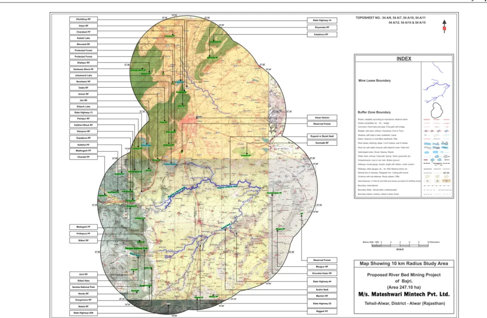
Nearest Railway station is Malakhera at an aerial distance of about 3.0 km in North direction. State Highway-25 and 44 passing through lease area. Nearest Airport is Jaipur International Airport at an aerial distance of about 93 km in SW direction. District headquarter Alwar is about 4.0 km in West direction.
Post and Telegraph, Hospital, Bank, Education and all market facilities are available at these places.
(ii) Land Form, Land Use and Land Ownership
Total mine area of 247.10 ha for the proposed project is Gair Mumkin Nadi & Nallah as available in revenue records.
It is not expected to have permanent change in land use but the same will be changed temporarily during the period when mining operations of Bajri will be undertaken. Natural replenishment of bajri during rainy season will be there. Plantation will be done on the Gair Mumkin Nadi & Nallah banks & approach road of the nearby villages.
(iii) Topography along with Map
The proposed mine area comprises of part of Gair Mumkin Nadi & Nallah. There is neither road nor habitation in the area.
(iv) Existing Land Use Pattern {Agriculture, Non-Agriculture, Forest, Water Bodies (Including Area Under CRZ)}, Shortest Distances From The Periphery Of The Project To Periphery Of The Forests, National Park, Wild Life Sanctuary, Eco Sensitive Areas, Water Bodies (Distance From The HFL Of The River), CRZ. In Case Of Notified Industrial Area, A Copy Of The Gazette Notification.
The proposed mine area is 247.10 ha. There is neither agriculture land nor forest land in the area.
TABLE - 4
ENVIRONMENTAL SETTING
S. No. Particulars Details
1 Nearest National Highway/ State Highway
State Highway- 25 (Passing through lease area) State Highway-44 (Passing through lease area) State Highway- 14 (~1.0 km in NW direction) State Highway-13 (~3.0 km in NW direction) State Highway-25(A) (~8 km in South direction) 2 Nearest Railway Station Malakhera Railway Station (~3.0 km in North
direction).
3 Nearest Airport Jaipur international Airport, (~93 km in SW direction).
4 National Park, Wildlife Sanctuary, Biosphere Reserve,
Sariska National Park (~1.5 km in West direction)
etc. within 10 km radius
6 Reserved / Protected Forests within 10 km radius
Reserved Forests
Shyamaka RF (~ 5.0 km in NE direction).
Kalakhora RF (~ 7.5 km in NE direction).
Reserved Forest (~2.0 km in North direction).
Duninath RF (~4.5 km in North direction).
Reserved Forest (~8.5 km in East direction).
Manjupur RF (~7.0 km in SE direction).
Khunteta Kalan RF (~2.0 km in East direction).
Macheri RF (~8.0 km in South direction).
Nandu RF (~7.5 km in SW direction).
Umri RF (~5.5 km in SW direction).
Dangarwara RF (~6.0 km in SW direction).
Baleta RF (~3.0 km in SW direction).
Silberi RF (~2.5 km in West direction).
Dholidhup RF (~2.0 km in West direction).
Alwar RF (~3.5 km in West direction).
Bhurasid RF (~6.0 km in NW direction).
Shahpur RF (~6.5 km in WNW direction).
Saidawas Block RF (~7.5 km in WNW direction).
Baraliwari RF (~4.0 km in NW direction).
Dabla RF (~8.0 km in West direction).
Umran RF (~4.5 km in WNW direction).
Jhir RF (~6.0 km in NW direction).
Paintpur RF (~9.0 km in NW direction).
Kalikhol Block RF (~6.5 km in NW direction).
Gainpura RF (~3.5 km in West direction).
Gopalpura RF (~4.5 km in NW direction).
Protected Forests
Rajgarh PF (~8.0 km in South direction).
Madogarh PF (~4.0 km in West direction).
Chanduli PF (~6.5 km in NW direction).
Protected Forest (~3.0 km in West direction).
Protected Forest (~4.0 km in WNW direction).
Kalikhor PF (~8.0 km in NW direction).
Madhogarh PF (~7.0 km in NW direction).
Chandol PF (~8.5 km in WNW direction) 7 Water Bodies (within 10 km
radius)
Ruparel Nadi (Part of Lease Area)
Sukhri Nadi (Part of lease area)
Silberi Nala (~3.5 km in West direction)
Siliser Lake (~7.0 km in NW Direction)
Jaisamand Lake (~1.5 km in West direction)
Kaduki Lake (~1.5 km in West direction) 8 Seismic Zone Zone – II as per IS: 1893 (Part-I) : 2002
(v) Existing Infrastructure
Nearest Railway station is Malakhera at an aerial distance of about 3.0 km in North direction. State Highway-25 and 44 passing through lease area. Nearest Airport is Jaipur International Airport at an aerial distance of about 93 km in SW direction. District headquarter Alwar is about 4.0 km in West direction. Post and Telegraph, Hospital, Bank, Education and all market facilities are available at these places.
(vi) Soil Classification
The soils in general are clay loam to clay in texture and moderately to less permeable and developing cracks in dry season.
(vii) Climatic Data from Secondary Sources
The area has semi arid zone type climate. Average rainfall remains between 300mm to 350mm per year. The maximum, minimum and mean temperatures of the area are 450 C, 30 C and 240 C respectively.
(viii) Social Infrastructure Available
The site is well connected with social infrastructure facilities like medical, post office, schools, police stations etc. and as such no constraints are envisaged in this aspect.
5.0 PLANNING BRIEF
(i) Planning Concept (Type of Industries, Facilities, and Transportation etc.) Town and Country Planning/Development Authority Classification
Proposed mining area falls in Govt. land (Gair Mumkin Nadi & Nallah). The mining lease will be granted after grant of Environmental Clearance by MoEF&CC, New Delhi. State Highway-25 and 44 passing through lease area. Transportation of Bajri from river bed face to consumers will be done by trucks/ tractor trolleys to consumer sites. The approach roads will be provided up to the river bed face of Bajri. The terrain of the river is almost flat. The temporary ramps will be made upto working sites. The ramps will be broken before monsoon and will be made good after every monsoon season.
(ii) Population Projection
Manpower required will be engaged from nearby areas. No significant influx of people is anticipated in the area.
(iii) Land Use Planning
The proposed mining lease area is 247.10 ha which comprises of Government land. Plantation will be done along the river banks outside the lease area during the lease period of 5 years. Infrastructure like offices, rest shelter will be maintained outside the lease area. The approach roads will be made in the lease area as well as outside the lease area.
(iv) Assessment of Infrastructure Demand (Physical & Social)
The applicant will assess the demand of infrastructure (Physical & Social) in nearby area of the proposed project site and same will be developed under corporate social responsibilities programs.
(v) Amenities/Facilities
The applicant will develop the Amenities/Facilities in the nearby area of the proposed project site as per requirement of local people the nearby area of under corporate social responsibilities programs.
6.0 PROPOSED INFRASTRUCTURE
(i) Industrial Area (Processing Area)
Proposed mining lease area is 247.10 ha and located in the rural area. All required infrastructure for the mining activities will be provided.
(ii) Residential Area (Non Processing Area)
This is not required as mine workers will come from nearby villages.
(iii) Green Belt Development
Plantation will be carried out at the approach road and river bank Within 5 years of lease period.
(iv) Social Infrastructure
The laborers will be from nearby villages that are purely dependent upon such mining activities because they are not skilled in any other trade and vocation.
(v) CONNECTIVITY
Nearest Railway station is Malakhera at an aerial distance of about 3.0 km in North direction. State Highway-25 and 44 passing through lease area. Nearest Airport is Jaipur International Airport at an aerial distance of about 93 km in SW direction. District headquarter Alwar is about 4.0 km in West direction.
Post and Telegraph, Hospital, Bank, Education and all market facilities are available at these places.
(vi) Drinking Water Management (Source & Supply of water)
Water requirement for drinking purpose will be fulfilled from nearby villages
(vii) Sewerage System
The domestic wastewater generated from mine and utilities will be disposed in Septic tanks and soak pits. No other sewerage system is required.
(viii)Industrial Waste Management
No industrial waste will be generated from mining activities; therefore, its management is not required.
(ix) Solid Waste Management
No waste will be generated from the said mining operations. The small boulders generated during excavations will be used for constructions of haul roads.
Unused material including mineral or spillage (if any) will not be stacked on the banks as it will hinder the flow of river in monsoon season.
(x) Power Requirement & Supply/Source
Electric power is not required as mine will be operated in day hours only. The machinery will be diesel operated.
7.0 REHABILITATION AND RESETTLEMENT (R & R) PLAN
(i) Policy To Be Adopted (Central/State)In Respect Of The Project Affected Persons Including Home Oustees, Land Oustees And Landless Laborers (Brief Outline To Be Given)
The entire mine Area i.e. 247.10 ha is Govt. land (Gair Mumkin Nadi & Nallah) and as there is no habitation, therefore, no displacement of population is involved.
8.0 PROJECT SCHEDULE & COST ESTIMATES
(i) Likely Date Of Start Of Construction And Likely Date Of Completion
The mine will be started after obtaining Environmental Clearance from the MoEF&CC, New Delhi.
(ii) Estimated Project Cost Along With Analysis In Terms Of Economic Viability of the Project
Cost for Environment Protection for the Proposed Mining Project
Capital cost : Rs 4.0 Lacs/-
Recurring Cost per annum : Rs. 2.5 Lacs per annum/-.
9.0 ANALYSIS OF PROPOSAL
(i) Financial and social benefits with special emphasis on the benefit to the local people including tribal population if any.
Proposed riverbed mining project will result in growth of the surrounding areas by increased direct and indirect employment in the region.
Development of social amenities will be in the form of medical facilities, education to under-privileged children and creation of self help groups.
No major adverse effects on environment are envisaged in collection of Bajri from Gair Mumkin Nadi & Nallah.
LIST OF ANNEXURE
S. NO.
PARTICULAR
1.
LETTER OF INTENT
2.
KHASRA DETAILS
Department of Mines (Group-2)
Reference: - P.6(4)Mine/Group-2/2014 Dated 05.12.2014
M/s. Mateshwari Mintech Pvt Ltd Flat No 706, B Block, Athena building,
Jaysingh Highway, Bani Park Jaipur (Rajasthan)
Subject:-Mining lease area 247.10 ha Khasra area of Gair Mumkin Nadi & Nallah falling in Revenue Villages of Tehsil-Alwar, District: Alwar (Rajasthan) in favor of M/s. Mateshwari Mintech Pvt
LtdFlat No 706, B Block, Athena building, Jaysingh Highway, Bani Park Jaipur (Rajasthan)
Sir,
With reference to the above subject State Government has intention for the grant of Mining Lease in your favor for 247.10 ha as per Rajasthan Minor Mineral Concession Rules, 1986. So, fulfill the following condition within one year period.
1. Approved Mining Plan along with Progressive Mine Closure Plan by concerned authority. 2. Environment Clearance under notification 14.09.2006 of MoEF may be obtained.
3. Financial guarantee may be submitted as per rule 37 (J).
Yours
faithfully
Joint Secretary,
Ref.No
Copy forwarded for information and necessary action to: 1. Director, Mines & Geology Deptt, Rajasthan, Udaipur
1 Ahirbas 2988/1 Total 1 2 Indragarh 1 43 79 355 356 405 406 409 411 Total 9 3 Ulahedi 5 299 301 Total 3 4 Kairwara 2 5 336 337 354 1115 1116 1130 1131 1137 1138 1150 1151 1152 1169 1180 1258 1259 1260 1477 1508 1509 1510 1519 1520
1654 1681 1682 1696 1697 1713 1714 1719 1720 2312 2313 2321 2326 2327 2328 2353 2354 2357 2358 2359 2401 2402 2403 2436/2551 2437 2471 2480 2481 2504 Total 56 5 Kairwari 132 292 300 301 302 349 350 567 Total 8 6 Kairwa Jat 1518 1520
1692 Total 4 7 Kairwawal 1 142 Total 2 8 Kesarpur 707 733 Total 2 9 Khedli Saiyad 1964 1965 2037 Total 3 10 Khedli Pichnaut 1270 1469 1941 2052 2483 Total 5 11 Kharkhara 430 431 433 434 435 442 443 444 451 452 466 467 468 469 470 549 550 560 563 564 565 569 570
612 614 619 453 Total 29 12 Gujuki 127 128 414 420 512 514 562 651 Total 9 13 Gajika 77 78 79 80 81 384 Total 6 14 Ghegholi 931/1006 Total 1 15 Ghatla 679 721 1465 1466 1524 1525 1526 1527 1531 1672 1784 1785 1787 1797 1885 2078 2079 2080
2165 2847 2874/1557 13 Total 23 16 Chomu 1 538/2326 539/2327 624 656 697 702 1160 1203 1204/2335 1320 1331 1388 1404 1414 1706 1735 1881 Total 18 17 Chhajurampura 1 60 61 97 Total 4 18 Jatoli 393 513 773 774 Total 4 19 Dhhakpuri 1341 1343 1353 1368 1369 1424 1425
1465 1516 1529 1530 1536 1537 1538 Total 15 20 Dadar 1 1183 Total 2 21 Nangla Charan 289 463 464 Total 3 22 Nangla Jogi 184 193 194 206 207 390 408 411 480 Total 9 23 Nangli Sandh 81 85 208 216 Total 4 24 Naithala 1 2 305 334 336 379 381 387 388 506 568
571 598 624 637 645 647 760 789 1298 1551 2009 2429 2430 Total 25 25 Nangal Jhida 312 Total 1 26 Nangal Todiyar 8 Total 1 27 Naharpura Kalan 615 669 Total 2 28 Piladhaba 483 490 493 503 506 507 508 509 510 513 515 516 517 518/756 520 522 540 541 542 546/759
567 583 631 633 693 Total 26 29 Bandipura 1 1/760 2 3 78/757 81 Total 6 30 Barkhera 989 1002 1003 1090 1456 1457 1458 1459 1460 1461 1462 1463 1464 1465 1466 1467 1468 1730 1731 1747 1748 1450 1751 1752 2127 2164 2339 2320
2403 2445 2470 2471 2736 2757 2760 2784 2944 2965 2966 2967 2968 2987 3358 3384 3385 3386 3387 3388 3407/4267 3469 3470 3489 3495 3496 3497 3506 3507 3564 3565 3573 3575 3578 3579 3584 3656 3657 3658 3678 3681
3748 4092 4111 Total 74 31 Burja 616 693 Total 2 32 Bahadurpur Pattikatla 624 625 626 627 690 691 821/2330 867 868 914 915 916 917 Total 13 33 Badh Vilandi 232 Total 1 34 Bichpuri 2 4 7 Total 3 35 Modiya 311 324 411 433 257 Total 5 36 Moreda 269 270 271 274/676 540 642 661 662
37 Mohabbatpur 1 2 65 66 67 68 71 75 237 244 245 246 248 250 251 253 Total 16 38 Ratangarh 1 589 589/743 651 667 673 674 722 Total 8 39 Roopbas 257 257/466 266 266/467 267 268 327 328 329 331 332 383 401 424 Total 14
2 3 4 16 178 1559 2157 2161 2162 2168 2169 2185 2189 2190 2193 2254 2255 2256 2257 2258 2266 2268 2289 2309 2310 3086 3087 3630 3631 3632 3634 3635 Total 33 41 Satana 312 328 453 486 522 523 529 599
42 Sumel 55 59 63 65 75 665 855 855/2336 1491 1593 1595 1596 1598 1781 1935 2101 2102/2332 2106 2150 2151 2153 2166 2178 2179 2180 2181 2190 2191 2202 2203 2204 2205 2232 2233 2234 2235 2236 2237 2238 2239 2240
2302 2305 2306 2307 2308 2315 2316 2317 2318 2319 2329 Total 54 43 Salpur 781 917 918 922 923 1105 1111 1113 Total 8 44 Salpuri 456 509 534 535 538 649 650 659 669 Total 9 45 Shanpur 1 6 8 701 703 704 Total 6 46 Mahuwa Kala 834 1 47 Mahuwa Khurd 1062
1065 1116 1117 1118 1155 1155/1271 1158 1190 Total 10 48 Dholaplash 257 173 Total 2 49 Achalpuri 1 62 1053 Total 3 50 Roopbas 257 257/466 266 266/467 267 268 327 328 329 331 332 383 401 424 Total 14 51 Bhandodi 13 14 15 18 19 27 30 36 37 38
467 476 477 478 709 711/1955 982 983 1002 1003 1033 1035 1037 1052 1353 1778 1779 Total 28 Grand Total 601
Q6
31, 31,sns
{s-{R.
1934-q4
21,2012 1934-Jilne21,2012 ; qr.r4
(rr)sc_sg-s
(I)1If,r
rRrDn iPrr sral{rq-srBfirfuit
gpr
urft
ffi
Tn
Flqrq
.Trtdt,
sc-frEd
fffr
af
{fufrm
uoi
S$
srlaw
o,r{fr
frqql
MINES (Gr.II) DEPARTMENT
NOTIF'ICATION
,JaiPu4 June 21,2012
G.S.R 27.-
In exercise of powers conferred by rule654
of
The Rajasthan
Minor
Mineral Concession Rules, 1986, hereinafter,eferr"d to as the said ruies, the State Govemment in the interest
of
mineral development hereby
notiff
following
procedurefor
grantofconcession of mineratr bajri, namely
-'
-1.Mining
leases
for
mineral bajriwill
be granted as provided in naj asthan -Minor Mineral Concession (Amendment) Rules, 2012notifi-ed
vide this
DepartmentNotification
No'
F'14(1)
Mines,'GI.IL2C1
I
Cated 23-05-2012.2,
Till
such time that mining leases of bajri comes into force asoer
above
amendedrules,
Mining
Engineer
/
Asstt'
Mining
bngirre",
may recoverroyalty
aiongwithpermit
feesat.the
rates ore"scribed in-the said rules by establishing departmental check posti,
Uy*uy
of royalty cqllection contract for such period as decidedby the Director.
p"Ufi*,i"g
oftnil
deparftnent notification of even no' dated 2012 inofficial
gazette.[No. F-14(1) Mines
/Gr.IIl2011t
Bv
"
Order
of theGovernor'
frro Eqrc
ai-ffsrf,,Deputy Secretary to Government'
Goyerument of Ra.iasthan Mines (Gr. tr) Department it * T
i
:! ;) :!.. .li
t
,o, r
r#flffj.i,1di*,r1?*
H#f
tlis depanmenr refter ro. F.r4(r)Mines/Gr.rrlil*'Jf*ffi?itrflilffiT::yi::f*
inoo rorce as per above amended rues.O"rat"s
prlcriUea';;';;#;*."'gu?eer
mav recover rovaltv alongr,rdrh;;#;;;
royarty corection
",iL*,
il,
s.,ff'#f;
::,ffi:fiiffiTi"hJ-
o}#ff
;",;
;;
4. This aotification shall come i noria"*ion
or","o
ffi;ff
5r".r;,1
;:L*
:i:tr
pubrishing of rhis deparrmearBy
&d".
offlcor".onr,
Copy forwarded to the
followiag for inform^,,."
-,
::;;;::'.jffi'
)
* i=::,
lp
Govemor of Rajas*_.*,0*
*"-,
,
i
lii",ru;l*r**##il"
**iffi$il;
"'o*
i
f
""..,1-"nief secretary, Rajasrhan. Jaipur,:.
r.s.fo
pr. Secretary. Finr1
P's-,.
i"tri*,
,"'ilurance
Deptt' Raiasthan' Jaioui3
*::':;:;;"!,lil:;:fffl
li,1rff.**"
Depu" Raiasthan, raipur'.
^
--:ffi1,:;'l..
-&ffi#'';i"f$;n,"
rnreuigence (sDRD,
vitt
Bhawan,
:
i#::tJ:fm[::f;"?*1:g1o"**a*
udaipur with requesito circurate in.a, the$B*rg*r
.
.
Asstt Seeretary toGovt-No. : F.l4(t)Mines/Gr.Il20t
i
?
J,4ii
?gB
Jaipur, dated :