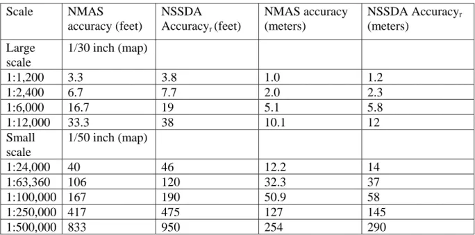
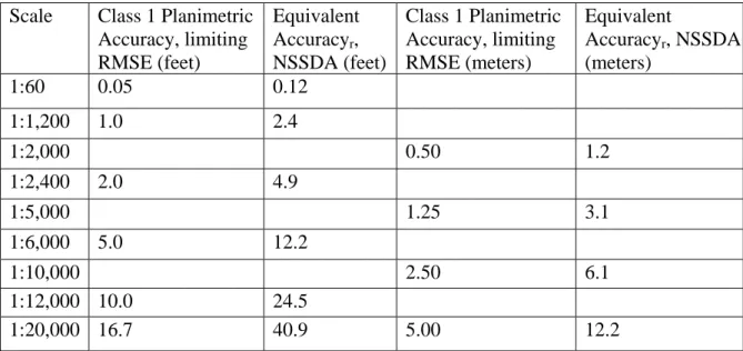
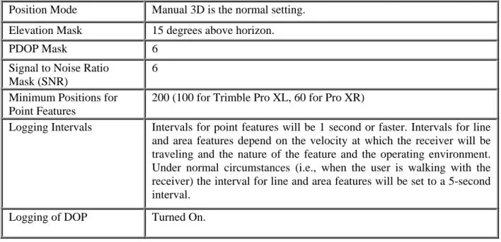
100 North Road (Route 513) | Chester, NJ 07930-2322 | (908)879 6737 | www.highlands.state.nj.us
Lake Management Plan
Guidance
Release Date: January 2014
AbstractThis technical document is intended to be used by planning and science professionals within a municipality to aid in the development of an Adaptive Lake Management strategy, by providing the tools to analyze lake management needs, set corresponding goals, identify appropriate solutions, implement those solutions, and establish ongoing monitoring and management tactics.
Although this document is intended primarily for use by municipalities within the Highlands Region (and grant funding is available to support associated work for municipalities that are conforming with the Highlands Regional Master Plan) the principles, strategies and methods outlined within are applicable to any municipality and may be of interest to other stakeholders.
i
Statutory Platform, Purpose and Funding
Through the passage of the New Jersey Highlands Water Protection and Planning Act in 2004, the NJ Highlands Water Protection and Planning Council (the Highlands Council) was created and charged with developing a Regional Master Plan (RMP).* Adopted in 2008, the RMP serves as the guiding document for the long-term protection and restoration of the region’s critical resources. This Lake Management Plan Guidance document was developed in accordance with Objective 1L6a of the RMP, which directs the Highlands Council to provide guidance related to watershed delineation, pollution sources, lake management techniques, and best management practices.
This is a technical document, intended to be used by planning and science professionals within a municipality to aid in the development of an Adaptive Lake Management strategy, by providing the tools to analyze lake management needs, set corresponding goals, identify appropriate solutions, implement those solutions, and establish ongoing monitoring and management tactics.
Funding to support this work within a municipality is provided through the Highlands Plan Conformance process. Municipalities with approved Plan Conformance Petitions are eligible for grant funding to cover the reasonable expenses of planning activities associated with the Conformance process and should contact their Highlands Council Municipal Liaison for additional information.
* Copies of the Highlands Regional Master Plan are available in most municipal offices and can be obtained by contacting the Highlands Council office.
List of Preparers
This document was prepared by the following firm(s)/individual(s) with project management from Highlands Council technical staff.
Steve Souza
Princeton Hydro, LLC 1108 Old York Road, Suite 1 P.O. Box 720
Ringoes, New Jersey 08551 908.237.5660
www.princetonhydro.com
Table of Contents
Statutory Platform, Purpose and Funding ... i
List of Preparers ... ii
Introduction ... 1
Chapter 1 — Lake Management within the Highlands Region: Historical Overview ... 3
1.1 The Lakes of the Highlands Region... 3
Chapter 2 — An Overview of the Process and Impacts of Lake Eutrophication... 5
2.1 Eutrophication... 5
2.2 Lake and Watershed Interactions ... 5
Chapter 3 — Basic Tenants of an Adaptive Lake Management Plan ... 8
3.1 Introduction to Lake Management Planning... 8
3.2 Adaptive Lake Management ... 9
Chapter 4 — Getting to Know Your Lake... 12
4.1 Getting Started ... 12
4.2 Moving Forward... 12
4.3 Lakes and Ponds are Defined by Physical, Chemical, Hydrologic, and Biological Interactions ... 12
4.4 How Much Data? ... 13
4.5 Goal Setting ... 14
4.6 Gaining Public Support ... 15
Chapter 5 — Preparation of an Adaptive Lake Management Plan ... 16
5.1 Database Development ... 16
5.2 Limnological Data Collection and Analysis ... 17
5.2.1 Primary Components ... 17
5.2.2 Secondary Components ... 31
5.3 Incorporation of Limnological Data into Management Plan ... 33
Chapter 6 — Synopsis of Commonly Implemented Lake and Watershed Management and Restoration Techniques and Strategies ... 34
6.1 Watershed Management Strategies... 34
6.1.1 Public Education and Outreach ... 34
6.1.2 Canada Geese Control ... 36
6.1.3 Septic Management ... 36
6.1.4 Shoreline and Stream Bank Stabilization ... 37
6.1.5 Stormwater Management ... 38
6.1.6 Preservation of Existing Land ... 39
6.2 In-Lake Management Techniques ... 39
6.2.1 Drawdown ... 40 6.2.2 Aeration ... 40 6.2.3 Dredging ... 41 6.2.4 Macrophyte Harvesting ... 41 6.2.5 Algaecides ... 41 6.2.6 Herbicides... 42 6.2.7 Fishery Biomanipulation ... 43 6.2.8 Nutrient Inactivation ... 43
Chapter 7 — Data Summary ... 45
7.1 Data Compilation and Reporting ... 45
7.2 Quality Assurance/Quality Control ... 45
Glossary of Commonly Used Terms ... 46
References ... 55 Appendix A: Lake Management Case Studies/Success Stories
Appendix B: NJDEP GIS Mapping and Digital Data Standards Appendix C: Highlands Technical Documentation Template
Introduction 1
Introduction
Within the boundaries of the New Jersey Highlands Region lies the greatest cluster of the largest lakes and reservoirs in New Jersey. A vast network of head-water streams, rivers, riparian corridors and wetlands are part of the watersheds draining to these waterbodies further defining and accentuating the natural resource value of these lakes. As per the Highlands Regional Master Plan (2008), cumulatively the region’s lakes, streams and wetlands account for well over 122,000 acres and the associated riparian areas account for approximately two-fifths of the entire Highlands Region. While some of the region’s lakes are natural, geologically created features of the landscape, most are man-made impoundments. Many were constructed as far back as the Revolutionary War and helped shape the area’s early land development patterns. Some had commercial importance providing hydro-power for local mills and foundries while others were an integral part of the barge canal transportation system that linked the eastern and western parts of the state. Many of the region’s lakes, such as Lake Hopatcong, Lake Mohawk, Swartswood Lake and Greenwood Lake have long storied histories of serving as major recreational waterbodies, tourist destinations and local attractions. Today the lakes of the New Jersey Highlands Region are among the most heavily utilized water-based recreational facilities of the State.
In the latter part of the 1900s, the communities surrounding the majority of the Region’s lakes transitioned from sleepy, summer enclaves to major population nodes. In almost every case this triggered changes in the character and ecology of these lakes. The features that originally attracted people to these lakes (clear water, natural shorelines, an abundant fishery, etc.) over time became compromised as land was cleared, developed and paved. Algae blooms became more prevalent, changes in the fish and wildlife communities occurred, and water quality in general began to deteriorate. These are all common results of the acceleration of the lake eutrophication process. While eutrophication, or the “aging” of a lake, is a natural occurrence, anthropogenic activities can radically speed up the process and cause a wide array of water quality and ecological problems that negatively affect the aesthetic and recreational attributes of the waterbody.
High standards have been set by both area residents and seasonal users for the region’s lakes and ponds. The public mandates maintenance of a high level of water quality for each lake and pond, even with the increased transformation, encroachment, and development of their surrounding watershed. This makes managing the lake resources of the New Jersey Highlands Region very challenging. To meet these somewhat diverging goals, technically sound, pro-active lake and watershed management is needed. Accomplishing this objective is daunting and cannot be achieved without a properly prepared lake management plan.
A successful lake management plan requires good science, planning and engineering. It also requires an understanding of the functional goals, objectives and vision of the lake community. As such, the
Introduction 2
development of the plan is both a scientific and social effort. At the end of the process, if done correctly, the lake management plan becomes the ecological blueprint for the immediate and future proper care of the subject lake.
Although all lake and pond ecosystems benefit from proper management and maintenance, the approach taken when dealing with a relatively un-impacted lake will be different, though related, to the approach taken when dealing with a highly impacted lake. For the former, the effort will focus more on preservation and enhancement, while for the latter, restoration and mitigation will need to be emphasized. Basically, this means that there is no “standard” strategy or approach for the management of a lake. Although each lake and pond ecosystem is unique, certain strategies, such as nutrient load reduction, are fairly universal elements of most lake management plans. This is why each lake and pond needs its own management plan so that each waterbody’s challenges can be correctly assessed and the proper remedial measures implemented.
Throughout this guidance document, the concept of Adaptive Lake Management will be emphasized. As will be detailed in Chapter 3, Adaptive Lake Management is a dynamic process that is grounded in the preparation of a technically sound database. The data define and quantify the key attributes of the lake and its watershed. The subsequent analysis of these data will lead to the correct identification of the waterbody’s problems and the proper prioritization of the management and restoration measures needed to correct those problems. When approached in this manner, there is an increased certainty that the implementation of the selected restoration and management measures, actions and techniques will lead to sustainable improvements in lake quality. The plan’s ultimate goal is the control of the eutrophication process. As will be demonstrated, a properly conceived and developed plan will enable a lake community to maintain the ecological requirements of the lake or pond and satisfy the aesthetic and recreational needs of the user community.
In summary, the purpose of this document is to provide the reader with guidance in the preparation of a lake management plan. It can be viewed as a “cook book” or “blueprint” that identifies the “what” and “how” of preparing a successful plan and then implementing that plan using an adaptive management approach. Following the Adaptive Lake Management approach, the plan itself is by definition intended to be modified over time to account for “lessons learned, successes, new information, changes in the lake and public input.” It is thus organic and by design meant to aid the community in meeting existing lake management challenges while at the same time serving as the framework for ongoing management needs.
Chapter 1 - Lake Management within the Highlands Region: Historical Overview 3
Chapter 1 — Lake Management within the Highlands Region:
Historical Overview
1.1 The Lakes of the Highlands Region
There is a great diversity of lake ecosystems within the Highlands Region. Some waterbodies are relatively pristine (such as Wawayanda Lake in Vernon Township, Sussex County) and have remained unaffected by watershed development, while many others are highly altered and characterized by conditions clearly resulting from accelerated eutrophication. As such, the region’s lakes span a broad range of biological productivity; often referred to by lake scientists as “trophic state.” Those waterbodies with the least developed watersheds typically fall into the oligotrophic (low productivity) class. Those with moderately developed watersheds are often characterized as mesotrophic (medium productivity) waterbodies. The lakes and ponds having the most extensively developed watersheds range from moderately to highly eutrophic (highly productive) waterbodies. As noted in the Introduction, the vast majority of lakes and ponds in New Jersey are man-made or man-enlarged. Most lakes were created by damming a river or by erecting a dam to expand the impounded area of a naturally created, glacial lake. Many of the region’s ponds were excavated to tap into the groundwater or created by diverting water from an adjacent stream or wetland. Regardless of their origin, the region’s lakes and ponds provide recreational, aesthetics, water power/supply or commercial functions and services to the surrounding communities. The fact that people are attracted to lakes is part of the reason why the watersheds of the Highlands Region’s lakes became increasingly developed over the past few decades. However, as a watershed develops, the attributes that draw the public to these lakes become compromised. Increased human activity leads to changes in the ecology of the lakes and a decline in water quality. Sediment infilling, larger and more persistent algal blooms and greater aquatic weed growth are some of the more common impairments triggered by accelerated eutrophication. Although the public cannot easily relate to “elevated phosphorus levels” or “exceedances in total suspended solids,” they do relate to the ramifications of algae blooms, nuisance densities of aquatic weeds, beach closures, declining fisheries and lost water depth.
The development of lands around the Region’s lakes for the most part intensified in the 1950s. This led to stormwater and wastewater related issues that quickly started to negatively affect the lakes. With respect to stormwater runoff, the common practice was to essentially collect, concentrate and then discharge the stormwater into the lake with little thought given to the negative consequences of the sediments, nutrients and other pollutants present in the runoff. With respect to wastewater, treatment was accomplished using very rudimentary techniques. When present, septic systems tended to be undersized because the homes were intended only for summer use, not year-round residency. Because the Region’s native soils have limited depth to groundwater or bedrock, the actual level of wastewater treatment provided by these systems tended to be limited as well. As the
Chapter 1 - Lake Management within the Highlands Region: Historical Overview 4
communities aged, development intensified, summer homes were converted to full-time residences, and stormwater and wastewater impacts became increasingly pervasive and significant.
The above noted changes in land use and watershed development have led to water quality problems and impairments. However, these problems are not unique to the lakes of the New Jersey Highlands Region, but have occurred nationwide. Presently, most of the water quality problems facing the nation’s lakes are a function of non-point source pollution that can be directly linked to land development, inadequate stormwater management, suboptimal septic management and an ecological disconnect between the lake and its watershed. This decline in water quality is accompanied by a loss in the aesthetic attributes and recreational opportunities provided by these waterbodies.
As difficult as it may seem, facilitating multiple lake community goals including watershed development, social needs and expectations, and maintenance of the ecological integrity of a lake ecosystem can be achieved. To be successful, the long-term management of the causes and impacts of the lake’s accelerated eutrophication must be correctly defined and quantified. This process begins with developing a clear understanding of the ecological and assimilative capacity of the lake ecosystem in question. Thus, before initiating any restoration efforts, a sound water quality database must be developed. This database must encompass the critical elements of the lake’s hydrology, morphometry (shape), water chemistry, biota, pollutant load and trophic state. The management plan needed to correct the lake’s problems and protect it from further degradation must evolve from these data. A lake management plan, when properly formulated, can provide the balance between the contradictory goals of watershed development and lake restoration.
Chapter 2 — An Overview of the Process and Impacts of Lake Eutrophication 5
Chapter 2 — An Overview of the Process and Impacts of Lake
Eutrophication
2.1 Eutrophication
As previously discussed, the majority of the negative water quality impacts to the lakes of the Highlands Region are due to non-point source pollution and accelerated eutrophication. Other issues that necessitate the implementation of some form of management or planning on the community level include competing recreational uses, shoreline clearing/modification, and water level manipulation. However, it is excessive macrophyte and algae growth that lead to the lake quality impacts that most often trigger the need for lake management. This excessive growth and related problems are the direct result of nutrient loading, which causes lake eutrophication. In order to properly and successfully manage a lake, it is important to fully understand the process of eutrophication, from its causes to its ramifications.
Eutrophication is a natural process that affects all lakes, reservoirs and ponds. The North American Lake Management Society (NALMS, 2004) defines eutrophication as an increase in biological productivity stimulated by the introduction of inorganic nutrients and organic matter. This increase in biological productivity is typically reflected as an increase in the density of phytoplankton, filamenous algae and/or macrophytes (aquatic weeds). In northern New Jersey increases in phosphorus loading is most often the primary factor responsible for the enrichment of the waterbody leading to this increase in biological productivity. While eutrophication is commonly defined as increased biological productivity, there are a multitude of other symptomatic effects associated with eutrophication including increased sedimentation, declines in species diversity, altered water transparency, prevalence of invasive species and altered dissolved oxygen and nutrient dynamics. While the implications of eutrophication are far reaching, the causes of eutrophication are initially derived from the watershed.
2.2 Lake and Watershed Interactions
As introduced in Chapter 1, there is a direct linkage between a lake and its watershed. What is often lacking in lake management plans is the study and understanding of this linkage. NALMS promotes the notion that a “lake is a reflection of its watershed,” meaning that the condition of a lake is directly related to the condition of the lake’s watershed. Lakes categorized as low-productivity are usually associated with watersheds characterized by little if any disturbance, whether residential/commercial development or agriculture. Conversely, highly productive lakes are most commonly associated with watersheds that have become extensively developed or intensively farmed. As such, it is fair to state that eutrophication-related problems observed in a lake are primarily linked to the nature of the lake’s contributing watershed. In short, there is a direct relationship between the rate of lake eutrophication and the intensity of development and related land uses occurring within the lake’s watershed.
Chapter 2 — An Overview of the Process and Impacts of Lake Eutrophication 6
The reason for this direct linkage is the relationship that exists between land development and pollutant transport. Over time, as the lands surrounding a lake evolve from an undisturbed, forested state to farmland, suburban development and/or cityscape, there is an associated loss of the natural processes and ecological services once characteristic of the watershed. This is best reflected in increases in the volume and rate of stormwater runoff and the decrease in the recharge of precipitation that occurs as a watershed becomes progressively developed. This change is triggered by the loss of natural ground cover and vegetation, increased compaction of soils and an increase in the amount of impervious cover (pavement), and the direction of stormwater flows to concentrated channels. These types of land use changes promote the generation of stormwater runoff, as opposed to the infiltration and recharge of precipitation.
As previously noted, the resulting increase in runoff volume and the rate at which this runoff is generated during every storm event sets the stage for the increased mobilization and subsequent transport of “pollutants.” Initially, as the vegetation and landscape of a watershed is altered from a natural state to a developed condition, most of these “pollutants” may be in the form of eroded soils and dissolved and particulate nutrients (phosphorus and nitrogen). As the watershed becomes increasingly developed, the concentration and total amount of these pollutants transported into the lake will increase. Depending on the type of development, the variety of pollutants will also increase and may include pollutants such as nutrients. pesticides, petroleum hydrocarbons, pathogens, and heavy metals. These pollutants not only affect the lake’s productivity but can impair the lake’s biota through decreasing species richness and create health-related issues for humans.
Increased agricultural use also modifies watersheds, often through soil disturbance and fertilizer and pesticide inputs. Tilling of the soil may allow the creation of rills and gullies, transporting water faster to the streams feeding a lake. Although most of the Highlands Region’s larger lakes have limited agricultural land within their drainage areas, there are a number of watersheds supporting a fair amount of agricultural uses.
The increase in the rate and volume of runoff associated with watershed development will also start to degrade the stability, ecology and water chemistry of the lake’s tributary streams. Not only does this damage the environmental integrity of these waterways, but it increases the introduction of silt and sediment to the receiving lake as a result of stream bed and bank erosion. These problems are further exacerbated by encroachment of development into the floodplain and riparian areas associated with these streams. This increases the frequency and magnitude of flooding, stream bank erosion, and pollutant transport. The common response to the flooding and erosion of streams triggered by watershed development and floodplain encroachments has been to channelize the impacted streams, or even worse, place the flow from these streams into pipes and culverts. These types of “corrective actions” further disconnect the lake from all of the natural functions and ecological services of its attendant streams and contributing watershed resulting in only more runoff, erosion and pollutant related impacts. The resulting siltation can also reduce lake depth, which may facilitate excessive weed growth and increase boat damage.
Chapter 2 — An Overview of the Process and Impacts of Lake Eutrophication 7
In short, the anthropogenic alteration of a lake’s watershed hastens the eutrophication process, a condition referred to as “accelerated cultural eutrophication.” In addition to an increase in autotrophic productivity, there are additional water quality impairments associated with eutrophication such as increased sediment infilling, declining species diversity, and declines in water clarity. The water quality problems that then arise reduce the lake’s ability to satisfy its ecological, recreational, and aesthetic functions. It is often at this point that the lake community realizes there is a problem and initiates actions intended to remediate the lake and restore its functions. Unfortunately, the management plans developed in response to declining recreational use and aesthetics tend to be very reactive and focused on addressing the symptoms of eutrophication. Such plans are never successful over the long-term.
Chapter 3 — Basic Tenants of an Adaptive Lake Management Plan 8
Chapter 3 — Basic Tenants of an Adaptive Lake Management Plan
3.1 Introduction to Lake Management Planning
There are eight basic steps in the development of a lake management plan:
1. Organize Stakeholders – Bring together and organize stakeholders and others willing to participate actively in the management of the lake.
2. Conduct a Situational Analysis – This analysis involves the integration of the management goals of the lake community with the scientific attributes of the lake. Although the lake management plan will be largely based on the various limnological and watershed related data, valuable and insightful information and direction will be obtained through input obtained from the community of lake users and residents regarding their “vision” of the lake.
3. Set Measurable Goals and Objectives – A successful lake management plan must have clearly defined objectives and both short and long-term goals. The refinement of vision into clear, distinct, measurable objectives will allow for logical, systematic progress towards improving lake conditions and achieving the goals of the lake user community.
4. Evaluate Solutions and Alternatives – Given the complexities and intricacies of lake ecosystems, multiple options may exist by which short- and long-term management goals may be met. Prudent decision making during this step of plan development will help identify the most technically feasible and cost-efficient options to meet a specific management objective. Solutions should be evaluated in a holistic manner that addresses both the lake and its watershed. Doing so will often support the prioritization of watershed-based corrective actions in the advancement of the implementation of substantial in-lake management efforts (e.g., dredging versus sediment control).
5. Identify All Regulatory Constraints and Required Permits – Although lake restoration and management are environmentally positive actions, they are often regulated by Federal, State and Local rules, laws or ordinances. It is important to identify early in the process the regulatory constraints and identify any permits or approvals that will be needed in order to implement the various elements of the management plan. Thus it is imperative to review the plan and plan components within the context of Federal and State regulations, local zoning requirements and/or ordinances and other regulatory related factors that will come into play in implementation of the management plan.
6. Take Action – The implementation of corrective actions represents the crux of the lake management plan. As has been emphasized, these actions need to be pragmatic and achieve both long- and short-term goals. Best management practices that reduce nutrient loading or
Chapter 3 — Basic Tenants of an Adaptive Lake Management Plan 9
otherwise help to correct lake impairment will often be prioritized. However, measures may also need to be taken to correct or control recreational use and aesthetic impacts. Although these may be short-term measures that address the symptoms rather than the causes of lake eutrophication, in many cases they will need to be elevated in terms of their prioritization in the plan given their direct benefit to the lake community.
7. Evaluate and Monitor Effectiveness of Implemented Actions – Lake management is not a precise and exact science. Lakes and their associated watersheds are extremely complex, dynamic systems. As such, implementation of even the best designed lake management plan may not yield the expected results. Therefore, continued monitoring should be conducted following implementation in order to gauge the relative success of the plan. These data will identify the need for changes to the plan. This adaptive management approach will enable the lake community to re-prioritize or tailor management plan elements. Recognizing this reality, the community must be patient. Improvements in lake quality or the correction of lake problems is often a slow process. A well-designed plan will recognize this prospect and will accommodate the needed flexibility without compromising the overall goals and objectives of the plan.
8. Reassess and Modify/Update Plan – Reassessment is an integral element of the adaptive management approach and serves to measure achievement of the plan’s short-term goals. Continual assessment of implemented lake management activities, their effects on the lake, and ever-changing lake conditions is critical. As the lake’s problems are addressed, mitigated or minimized, reassessment will serve to direct where future management efforts should be focused.
3.2 Adaptive Lake Management
Adaptive Management is a common technique used in management and restoration of natural resources. Adaptive Management acknowledges the complexity of ecological systems and sets out an approach that anticipates changing parameters and allows for contingency decisions.
Adaptive Lake Management deals with lakes as complex living systems and provides a flexible framework within which to set and then redefine management goals. The lake ecosystem is characterized by interactions among its physical, biological, chemical and hydrologic attributes. Modification of one lake attribute may trigger a change in another lake attribute. Adaptive Lake Management incorporates this dynamic nature and produces an adaptable management plan. The framework of an Adaptive Lake Management Plan will be discussed in greater detail in Chapter 4, but can be summarized by the following illustration.
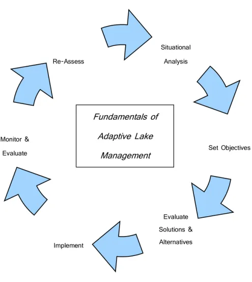
Chapter 3 — Basic Tenants of an Adaptive Lake Management Plan 10 Figure 1 – Adaptive Lake Management
The process begins with an assessment of existing conditions (Situational Analysis) and the identification of goals and objectives. Data are collected, alternative solutions are evaluated, and the recommended plan is implemented. Upon Monitoring and Evaluation, the effectiveness of the implemented restoration and management is measured and the management plan is modified as needed. Thus, as improvements are achieved in the water quality, aesthetic, and recreational attributes of the lake, a new Situational Analysis is conducted and Goals and Objectives are revised, leading to continued improvements. Ultimately, the goal of Adaptive Lake Management is a sustainable, ecologically balanced lake ecosystem.
This Lake Management Plan guidance document is designed to assist lake communities, whether private or public, in preparing a lake management plan that is grounded in the Adaptive Lake Management process. The goal is to provide stakeholders and those charged with the management and restoration of a lake, pond or reservoir with a road map leading to sustainable improvements.
Situational Analysis Monitor & Evaluate Re-Assess Set Objectives Evaluate Solutions & Alternatives Implement Fundamentals of Adaptive Lake Management
Chapter 3 — Basic Tenants of an Adaptive Lake Management Plan 11
Chapter 4 provides the framework for a detailed Situational Analysis. The Situational Analysis is the key to understanding your lake and is the fundamental first step in the lake management plan process. Chapter 5 provides specific technical guidance in collecting the data needed to properly investigate your lake. Finally, Chapter 6 provides an overview of some of the more commonly implemented lake management and restoration techniques.
Chapter 4 — Getting to Know Your Lake 12
Chapter 4 — Getting to Know Your Lake
4.1 Getting Started
As noted in the Highlands Regional Master Plan (RMP), the “Highlands Region lakes offer recreation opportunities, and are the defining features of many distinct communities.” The RMP also notes that the quality of many of the Region’s lakes has declined due to “overbuilt, damaged and poorly managed shoreland areas,” the influx of pollutants and loss of the ecological values associated with a well-functioning lake ecosystem. Reversing these impacts requires a well-designed and properly orchestrated lake and watershed management plan.
4.2 Moving Forward
The success of a lake management plan begins with properly identifying the root cause of the lake’s problem(s). This requires the collection of data and the preparation of a dataset robust enough to properly evaluate and ultimately rank those factors responsible for the root cause of the lake’s problems. Despite the complexity of a detailed lake study, a systematic lake management plan provides the direction and the focus that will allow for the successful attainment of both short and long-term management goals. This chapter presents:
• The framework of a technically sound lake study,
• How lake study data are used to develop the lake management plan, and
• How to engage the lake user community and other stakeholders in support of plan implementation.
4.3 Lakes and Ponds are Defined by Physical, Chemical, Hydrologic, and
Biological Interactions
The science of lake eutrophication involves studying and understanding the interactions that affect the overall ecological quality or “health” of a lake. It also involves investigating and understanding the linkages between a lake and its watershed. There are four basic categories of interactions that define a lake: physical, chemical, hydrologic, and biological.
Physical interactions are defined by the surface area, average (mean) depth, maximum depth and volume of the waterbody. These attributes of a lake or pond are relatively static and easy to measure. However, they are critically important, as they affect the other attributes of a waterbody. These are also “must know” attributes used in the design and implementation of some of the most basic lake restoration/management techniques such as aeration and algae treatments.
Chemical interactions are defined by the makeup of the water; that is the concentration of various minerals, nutrients and other dissolved and suspended constituents present in the water column. It is important to note that the chemical makeup of the water will change
Chapter 4 — Getting to Know Your Lake 13
seasonally and annually. As a result, this attribute is best defined by a robust dataset rather than collection of unlinked, sampling events.
Hydrologic interactions of lakes and ponds are among the most difficult to measure and are often either overlooked or inadequately studied. Although hydrologic interactions can be simplified to an understanding of the amount of water entering and the amount of water leaving a lake or pond over time, its quantification can be difficult. The hydrology of a lake or pond can be viewed as a conveyor belt bringing in nutrients, sediments and pollutants from the surrounding watershed and in turn flushing out the lake or pond. As with the chemical properties of a lake or pond, the hydrologic properties vary substantially from month-to-month and year-to-year.
While the Biology of a lake may appear somewhat straightforward, there are numerous linkages and interactions that necessitate studying the intricacies of the waterbody’s food-web. There are interactions that exist between phytoplankton and zooplankton, fish and zooplankton, as well as plants and algae that affect the water quality and appearance of a lake or pond, and greatly define the recreational and aesthetic qualities of the waterbody.
A clear understanding of these fundamental interactions is the foundation of an adaptive lake management plan. An adaptive lake management plan is the key to successful and sustainable lake restoration and management. The common thread connecting the case study examples provided in Appendix A is that each involved a study period that led to an analysis of the collected data that in turn led to the development of a comprehensive, multidimensional lake management plan. The ability to successfully improve the quality and sustain the condition of a lake is intimately linked to the fact that time was taken to understand the fundamental interactions defining the waterbody. The success of these projects is also a result of implementing a proactive approach that focuses on correcting the root cause of the waterbody’s eutrophication as opposed to simply reacting to the symptoms of eutrophication. The sustainability of the improvements is a function of the continued monitoring and re-evaluation of lake conditions, and the modification or re-prioritization of lake management efforts based on the data.
4.4 How Much Data?
The proper study of a lake requires data, as does the preparation of a comprehensive management plan. It is imperative that the database developed during the Situational Analysis phase of an adaptive lake management study provides enough critical information to examine and understand the various physical, chemical, hydrologic and biological interactions that define a lake or pond ecosystem. These data must also correctly establish the linkages between a lake and its watershed. Chapter 5 provides details concerning the sampling protocols, data collection techniques, desktop models, and various analytical tools used to assess the status of a lake or pond.
Chapter 4 — Getting to Know Your Lake 14
Prior to initiating data collection, any existing data should be reviewed. The information should be sorted into the four main categories of data collection needs: physical, chemical, hydrologic and biological. The quality of any existing data should also be assessed. For example: were the data collected following proper protocols or standard operating procedures? When examining laboratory results, confirm that the analyses were conducted by a NJDEP certified laboratory or university and that the detection limits (lowest measurable concentration) for key parameters are appropriate. It is common that detection limits for total phosphorus tests conducted by wastewater certified laboratories are too high (typically > 0.1 mg/L) making the resulting data of limited value. However, even if existing available or historic data do not meet quality standards for use in the preparation of the Lake Management Plan, these data can provide some insight into the lake’s overall conditions or help better define the severity of the lake’s problems. A source of data or information commonly falling into this category is algae and weed treatment daily or annual reports. At a minimum, these reports provide a good overview of the types of problem algae or aquatic plants present in the lake and the successes of the measures implemented to control this growth. However, because these reports tend to be more informative as opposed to technically based, they are not always a reliable data source for use in the preparation of the Lake Management Plan.
In terms of data minimums, the following is recommended:
• The area, maximum depth, mean depth and volume of lake
• Annual volume of water entering or leaving the lake
• Water quality data, consisting of the following, collected at least in April, May, June, July, August, October and November
o For lakes deeper than 6 feet dissolved oxygen (DO), pH, temperature, conductivity,
and total alkalinity data collected in profile from surface to bottom at 1 meter (3 feet) increments
o Total phosphorus and nitrogen concentrations measured at surface and bottom o Secchi clarity (Please note: because Secchi transparency is the simplest and easiest
measurement, this should be measured weekly.)
• Accurate identification of the types of zooplankton, phytoplankton and macroalgae present in the lake in May, July and August
• Accurate identification of aquatic plants present in lake, including assessment of each plant’s density and distribution as measured in May, July and August
4.5 Goal Setting
The Adaptive Lake Management approach requires stakeholders to set reasonable management or restoration goals and objectives. Because most of the problems affecting the lakes of the Highlands Region are a function of too much algae/phytoplankton growth, too much aquatic plant (weed) growth, or poor clarity, most lake management plans must include actions designed to reduce or control these impairments in a sustainable manner. For example, a reasonable goal for most of the
Chapter 4 — Getting to Know Your Lake 15
lakes in the Highlands Region is the maintenance of a mid-summer Secchi transparency depth of 1 meter (approximately 3 feet). A reasonable project objective linked to this goal would be to reduce the lake’s phosphorus load by, for example, 30%. Another related objective would be to control algae bloom development, for example by closely monitoring algal assemblages, implementing algal control strategies before peak bloom conditions, but doing so while limiting the use of algaecides (i.e., using algaecides in low concentrations, if at all).
In the case of goal setting, it is important to balance the previously referenced short-term user need solutions with the long-term water quality or ecological needs. While the ultimate goal of any lake management plan is to improve the overall quality of the subject lake by correcting the cause(s) of eutrophication, the symptoms of eutrophication must also be mitigated. Algae blooms, excessive weed growth, poor clarity, and sedimentation all directly affect the recreational use and aesthetics of a lake. Mitigation of these problems is therefore of critical importance to the lake users and stakeholders. Lake management efforts must be sensitive to the perspective of lake users and other stakeholders, addressing those circumstances that affect their view of the lake and its public benefits. As such, goal setting needs to focus on achieving sustainable, ecologically-based lake quality improvements, while improving the aesthetic condition of the lake for the benefit of lake users. An overview of the more commonly implemented in-lake and watershed based restoration and management measures are provided at the end of Chapter 5.
4.6 Gaining Public Support
The success of a lake management plan is weighted heavily by the ability to attain broad public support. Gaining public support requires outreach and engagement of lake stakeholders. The credibility of the lake management plan, and ultimately its success, is dependent upon endorsement from the various stakeholders. An effective lake management plan should provide assurances to lake users and stakeholders that the lake restoration recommendations and guidance will ultimately yield positive results.
Implementation of a lake management plan will occur in phases. The Solutions and Alternatives Evaluation component of the adaptive management approach will provide guidance concerning how to prioritize recommended management techniques. This step will also provide guidance concerning how to integrate and balance short-term and long-term restoration measures.
Sharing this information with stakeholders may ensure continuing public support. By keeping the user community and stakeholders informed and engaged, expectations are managed and the plan is allowed to evolve. This is also where balancing short-term and long-term restoration measures comes into play. By taking steps to control algae blooms, while at the same time implementing phosphorus reduction strategies, the immediate concerns of the lake users are satisfied, while still moving toward the attainment of the overall goal of the plan. Each of the examples provided in Appendix A had a strong public education and outreach element.
Chapter 5 — Preparation of an Adaptive Lake Management Plan 16
Chapter 5 — Preparation of an Adaptive Lake Management Plan
5.1 Database Development
The development of a successful lake management or restoration plan is predicated on the fact that each lake is unique. Each lake and its associated watershed should be viewed as an integral component of a biotic community of which humans are a part. A management plan should be designed to function holistically to help preserve the integrity, stability and beauty of the biotic community. All stakeholders in lake management, from lakefront homeowners and marina proprietors to drinking water users and future generations, should be considered when identifying problems and clarifying goals in the genesis of a lake management plan. A distillation of this process simply reflects the inclusion of all stakeholder opinions in the development of a management plan, as the success of lake restoration is not possible without the collective effort of the community. The community, in concert with guidance from a lake management professional, should come together to accurately define the specific problems the lake is facing and set up a plan that will:
• Collect the data necessary to identify the causes of eutrophication and other damage to lake functions,
• Utilize the data to assess and prioritize projects that will slow the rate of eutrophication and other lake impairments, and
• Implement these projects and assess water quality progress through monitoring.
Understanding the origin of the target lake, defining its current trophic state, and projecting water quality changes due to in-lake or watershed management efforts are key components in managing a waterbody and are the backbone of a proper lake management plan. This information can only be obtained through a proper diagnostic study which is comprised of a data collection phase, which serves to accurately characterize pertinent biological, chemical and physical components of a lake and its associated watershed.
The data collected from the diagnostic phase of a lake management or restoration plan are subsequently used as the empirical basis for the implementation of watershed and in-lake management efforts that will slow the rate of eutrophication and correct anthropogenic perturbations affecting the lakes or watersheds. Restoration/management efforts will ultimately address water quality problems identified in the initial phases of the plan and serve as the scientific means for slowing the rate of eutrophication and either restoring a waterbody to its original condition or improving water quality conditions so that the designated uses of the lake may be attained.
Lake management/restoration does not terminate once in-lake or watershed implementation projects have completed. These projects must be evaluated through post monitoring to gauge their effectiveness. Also, as previously mentioned, lakes are dynamic systems in a state of continual flux.
Chapter 5 — Preparation of an Adaptive Lake Management Plan 17
Any changes in nutrient loading, trophic dynamics, hydrology, watershed land use, or a myriad of other environmental conditions will ultimately result in a change within the lake ecosystem. While the goal of lake management/restoration is to implement changes that create positive environmental feedback, it is impossible to know the full implications of any lake management technique. As such, continued monitoring is necessary to collect the limnological data necessary to protect the biotic integrity of the lake.
The following sections of this document discuss several data collection components critical to the development of the diagnostic component of a lake management plan. Specifically, these components include defining a lake’s water quality, biota, morphometry, hydrologic and pollutant budgets, and trophic state. Each section will explain the applicability and utilization of the different data collection phases.
5.2 Limnological Data Collection and Analysis
5.2.1 Primary Components
This section provides a discussion of the applicability, utilization and methods for conducting a basic lake diagnostic study of lake systems greater than 50 acres in size. Simplified versions of these methods may be used for smaller lakes (i.e. < 50 acres) to gain similar information while using less refined techniques. As previously mentioned, lakes are dynamic systems and additional monitoring may be needed based on specific water quality issues or designated usages.
In-Lake Data Collection - Water Quality Monitoring
A central tenet to developing a successful lake management or restoration plan lies in identifying water quality impairments and taking corrective actions to mitigate the processes that are leading to degraded water quality. Water quality impairments are often experienced by lake users through aesthetic or recreational impacts such as unsightly or foul-smelling algal blooms or excessive densities of aquatic macrophytes, which impede boating, fishing or swimming. While observations are important in identifying water quality impacts, and are often the impetus for the development of a management plan, such information is highly subjective and is generally influenced by a person’s use of the lake and the water quality conditions that support such use. For instance, fishermen would generally prefer greater aquatic weed biomass as this would provide an ample base for a robust trophic web thereby leading to large game fish. Conversely, many boaters or swimmers may find the level of algal and weed growth a hindrance to their recreational enjoyment of the lake. Given the inherent variability in subjective measures of water quality, it is necessary to develop an empirical, scientifically based water quality monitoring program for each lake.
A properly designed lake monitoring program should serve to monitor key biological, physical and chemical parameters of a lake system and accurately account for the natural temporal and
Chapter 5 — Preparation of an Adaptive Lake Management Plan 18
spatial variability which exists in all lakes. Development of a water quality monitoring program need not be overly complex in order to develop a useful dataset that can be used to identify water quality impairments while helping filter out natural ecological variability or extreme conditions due to climatic or hydrologic conditions.
Foremost to the development of a proper lake management plan is the inclusion of all interested stakeholders such as lakefront residents, recreational users, waterfront businesses, municipal and county public works (where public roads are a major potential issue), municipal and county parks (where significant active recreational facilities are near the lake), or members of a lake association. The inclusion of those who have the greatest vested interest in the lake and are in the closest spatial proximity to the waterbody will provide incentive for both accurate and consistent data, two characteristics that are paramount to water quality monitoring. A water quality monitoring plan may be developed by volunteers or laypeople, but should include input from a qualified lake professional in order to monitor for those parameters that are most pertinent to lake systems while avoiding common pitfalls associated with collecting unnecessary data or frequent collection of parameters which generally exhibit little spatial or temporal variability. In addition, water quality monitoring can be carried out by lake professionals or volunteers, but only by the latter after they have received proper training. Once the personnel who are going to develop the monitoring plan are selected, some common questions and concerns need to be addressed. Given that lakes are dynamic systems, exhibiting variability in space and time due to both natural and anthropogenic factors, a water quality monitoring plan must account for this variability. At a minimum, most water quality monitoring plans are conducted monthly, from May through September, as this period represents the “growing season” for lakes in the Highlands Region. The growing season is the critical time during the year when the symptoms of eutrophication and excessive plant and algal growth are most pronounced and are the greatest nuisance to lake users. As such, many lakes, especially large lakes (surface area > 50 acres or complex in shape), should be monitored for in-situ parameters on a bi-weekly basis while discrete and plankton parameters should be monitored, at a minimum, on a monthly basis during the growing season.
In-situ parameters (temperature, specific conductance, dissolved oxygen and pH) should be sampled throughout the water column, at 0.5 – 1.0 meter depth intervals, on a bi-weekly basis. Monitoring of in-situ parameters is generally conducted utilizing a water quality meter that contains multiple sensors to analyze the aforementioned parameters. In addition, Secchi disk transparency should be measured, at a minimum, once every two weeks. The Secchi disk is a 20 cm disk, marked with alternating black and white quadrats, which is attached to a line or rope; demarcated in meters. In order to take a Secchi disk measurement, the user should lower the disk until it is not visible, retrieve slowly until visible again, and then average those two depths for the Secchi disk depth. This depth correlates with the amount of turbidity in the water and therefore provides an easy means of estimating water clarity and impairments due to suspensions of algae
Chapter 5 — Preparation of an Adaptive Lake Management Plan 19
or inorganic particulates. The Secchi disk depth, in meters, divided by 1.7 yields an attenuation coefficient for the available light averaged over the Secchi disk depth.
Discrete chemical sampling of nutrient parameters should occur, at a minimum, once every month during the growing season. Typical discrete parameters include total and soluble reactive phosphorus, ammonia, nitrate, total suspended solids and chlorophyll a. Alkalinity and hardness should also be measured once a month for the first year but only approximately every 3 years following the initial sampling as these parameters do not exhibit high temporal variability. Furthermore, the phytoplankton and zooplankton community should be sampled on a monthly basis and identified to, at a minimum, the most dominant genera.
Lake sampling stations are ultimately dictated by the morphometry (shape) of the lake. Those lakes that are round in shape, and of generally homogenous depth, may be sampled from a single, central location. Conversely, lakes with highly irregular shorelines should be sampled at a central, deep water location and throughout any significant coves as these areas may exhibit marked variations in water quality. Spatial variation in water quality in dendritic (branching) lakes may result from numerous factors including local influences from tributary inflow, shoreline residences, temperature variability, light penetration and prevailing winds.
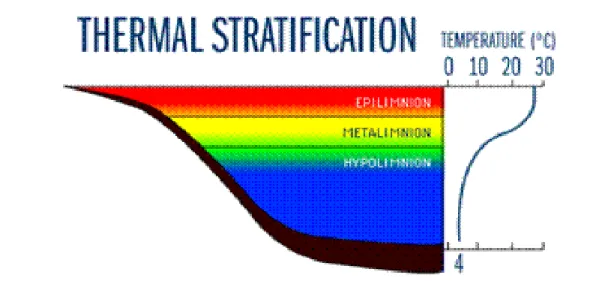
Figure 2: Thermal Stratification
Source:http://www.lakeaccess.org/russ/temperature.htm
At deep sampling stations (depth, or “Z” > 20 feet) lakes may exhibit strong thermal stratification during the growing season. Summer thermal stratification results when increasing solar radiation and air temperatures, in conjunction with a few days of little wind activity, combine to heat the upper portion of the water column. Thermal stratification consists of a relatively warm upper water layer, termed the epilimnion, a transition zone, termed the metalimnion or thermocline, and a cold, deep water layer, termed the hypolimnion (Figure 2). The density differences imparted
Chapter 5 — Preparation of an Adaptive Lake Management Plan 20
through thermal stratification serve to inhibit wind driven mixing of the water column thereby effectively sealing off the hypolimnetic layer from contact with the atmosphere. This phenomenon has important implications in that bottom waters of thermally stratified systems may become devoid of oxygen due to excessive bacterial decomposition of organic matter and a lack of atmospheric replenishment of dissolved oxygen through diffusion. Resultant conditions of hypolimnetic anoxia include internal sediment release of metals and phosphorus into the water column and reduced fish habitat. When the thermal stratification disappears (generally in the fall for most lakes), the metals and nutrients can cycle into the entire water column and cause major water quality changes. As such, water quality parameters within the epilimnetic and hypolimnetic zones are often markedly different. Therefore, in-situ measurement of temperature should be utilized to determine if the lake is thermally stratified. If stratification does exist, then discrete water quality samples should be taken approximately 0.5 m below the water’s surface and approximately 1.0 m above the lake’s sediment. Chlorophyll a should only be measured within the photic zone (approximately two times the Secchi depth) as this is the zone which receives enough sunlight for photosynthesis.
In-Lake Data Collection - Lake Morphometry/Bathymetric Surveys
Lake morphometry is defined as the physical dimensions of a lake and is determined through a combination of surface mapping and a bathymetric survey. Through bathymetric surveys, data are collected pertaining to the depths of water and unconsolidated sediments throughout a lake. Such data are commonly presented as maps which depict contour lines of water depth and depth of unconsolidated sediments. Furthermore, statistical data are calculated such as lake surface area, shoreline length and the depths and volumes of water and unconsolidated sediments. Lake morphometry, in concert with watershed characteristics, are the primary determinants of the physical, chemical and biotic characteristics of lakes. The shape of a lake basin can generally be broken down into three distinct zones which are primarily determined by lake origin but may be altered by anthropogenic activities both within the lake proper and throughout the watershed. These zones are as follows (Figure 3):
• Littoral Zone – The near shore region of lakes where the sediments lie within the photic zone, and where the shallow water flora is frequently dominated by macrophytes.
• Limnetic Zone – The open water region beyond the littoral zone. Primary productivity is dominated by phytoplankton.
Chapter 5 — Preparation of an Adaptive Lake Management Plan 21 Figure 3: Diagrammatic Cross Section of Lake Zones
As previously mentioned, while many of the lakes within the Highlands Region are of glacial origin, many are man-made or have been enlarged through the impoundment of inlet tributaries. The creation of man-made lakes, or enlargement of natural lakes, is commonly associated with an increased littoral zone. As such, many of these waterbodies are characterized by excessive macrophyte growth, which harms the aesthetics and recreational and ecological functioning of these waterbodies. The littoral zone may be further expanded through watershed development, which results in increased sediment erosion and transport to the lake thereby resulting in infilling and creation of deltas, which serve as prime habitat for weed growth. Conversely, some lakes may be characterized by steep shorelines resulting in a high limnetic : littoral zone ratio. In these lakes there is little suitable habitat for macrophytes, as such, primary productivity is dominated by phytoplankton.
Lake morphometry not only dictates the type of plant growth that will occur but also has a direct impact on the flushing time, which in turn affects nutrient retention and, ultimately, eutrophication. Many lake trophic models therefore utilize morphometric statistics in various forms to account for hydraulic retention and particle settling, which ultimately relate watershed based hydrologic and pollutant loading to in-lake nutrient concentrations and, ultimately, algal growth.
Given the importance of morphometric data in evaluating lake systems, it is critical that an up-to-date bathymetric survey is conducted on the target lake for the development of a proper lake management plan. Bathymetric surveys may be conducted in the field via one of two common methods dependent upon lake size and depth. For the purpose of this document, lake sizes are
Chapter 5 — Preparation of an Adaptive Lake Management Plan 22
broken down into two classes, those lakes between 10-50 acres in size and those lakes greater than 50 acres.
Echo sounding methods are commonly used to conduct bathymetric surveys in larger waterbodies where standard surveying methods are unfeasible due to time limitations or water depth restraints. Echo sounding methodology is the most advanced form of bathymetric survey methodology and is conducted through the utilization of a dual frequency sounder tied into a Global Positioning System (GPS) that continuously monitors vertical and horizontal datum along a series of pre-determined transects. The field data are commonly collected using specialized survey software and then imported into GIS for post-processing. Resultant information includes plan and cross-sectional maps that depict the depth of water and unconsolidated sediments of the lake. In addition, vital morphometric statistics such as maximum and mean depth, volume and lake surface area are calculated during post-processing.
Watershed Related Data Collection - Hydrology
Determining the hydrology of any lake is a fundamental step in gaining the full understanding of the overall chemical, physical and even biological dynamics of the system. A lake’s hydrology plays a significant role in governing the rate, amount and sources of pollutant loading to the lake. It also factors into the effectiveness or efficiency of primary producers in the assimilation of nutrients or in the rate of sediment deposition and accumulation. As such, the accurate quantification of a lake’s hydrologic properties is considered a critical element of any well-designed lake management plan.
Hydraulic retention time indicates how long a single drop of water, on average, is expected to be retained in a waterbody. Flushing rate is the opposite of retention time and is related to how many times the water in a lake is exchanged over a specified period of time. Flushing rate is derived by simply dividing the volume of all water inputs by the lake volume, while the retention time is simply the inverse of this metric. Both metrics (flushing rate and hydraulic retention time) have classically been computed on an annual scale. This may be acceptable in most cases, but numerous studies, including investigations of lakes in the Highlands Region, have shown that these properties change seasonally as a result of seasonal differences in rainfall, soil moisture content and vegetative evapotranspiration. As a result, there is greater utility and better representativeness of the data when these metrics are computed on a monthly basis. As would be expected, when calculated on a monthly or seasonal scale, flushing tends to be quicker in the spring and slower in the summer. These temporal variations in flushing and retention are of utmost importance in assessing lake trophic state due to the aforementioned direct relationships between hydrology and nutrient loading, nutrient assimilation and phytoplankton, algae and even macrophyte growth. Additionally, large individual flushing events may physically disrupt the formation of nuisance phytoplankton blooms. Therefore, having a good understanding of a lake’s flushing rate and hydraulic retention time is a very important element of any lake study.
Chapter 5 — Preparation of an Adaptive Lake Management Plan 23
Generally speaking, watershed size and lake volume are the primary components that dictate flushing time (or hydraulic retention time). Small lakes (volume and/or surface area) with large watersheds, typical of most impounded systems, tend to have quick flushing rates (< 180 days). Conversely, when the watershed area is small in relation to lake volume, the flushing rate tends to be slow.
Hydrologic loading can change over time as a result of watershed development. These types of changes are usually more dramatic for small watersheds as opposed to large watersheds. Regardless, as vegetated land is converted to impervious areas or areas of compacted soil, the rate and volume of stormwater runoff is increased. This change in land cover has an acute impact on both storm specific hydrologic and pollutant loading, as well as a cumulative impact on the overall flushing and retention properties of the lake.
There are various means by which to measure the hydrologic properties of a lake. These techniques span the continuum of detailed in-field studies involving the measurement of surface water, groundwater, and direct precipitation loading to models that use various algorithms to simulate or predict hydrologic loading. As will be discussed below, although there are advantages and disadvantages to each approach, the combined application of field data collection and modeling tends to generate results of suitable detail and accuracy for use in lake management plans.
Watershed Related Data Collection - Pollutant Loading
As noted above with respect to hydrology, the interconnectivity between lakes and their watersheds is a central tenet in lake management. This also holds true with respect to the assessment and quantification of pollutant loading. First, it must be emphasized that when dealing with lake systems from the perspective of trophic state analysis, the pollutants of concern are total phosphorus, total nitrogen, and sediment.
Watershed size, along with land use/land cover, soil types, topography and geology, all influence the quantity of water, its temporal distribution and the pollutant load associated with inflows to a lake. As discussed in the Introduction, a direct correlation exists between watershed disturbance and increased lake eutrophication. The conversion of forests to residential, commercial and industrial lands brings about an increase in impervious surface, which serves to alter the hydrologic cycle through increasing surface water runoff while decreasing groundwater infiltration. Associated with increased surface water runoff is increasing amounts of phosphorus, nitrogen and sediments. These pollutants stimulate excessive algal and weed growth within the receiving lake. Most of these pollutants originate from diffuse, ubiquitous sources and enter the lake on a landscape scale. The input of pollutants in this manner from diffuse sources is referred to as non-point source (NPS) loading. The recognition of the effects of non-point source pollution on lake water quality has increased over the past three decades. The USEPA reports that over 70% of all the existing water quality impairments affecting lakes is the result of NPS
Chapter 5 — Preparation of an Adaptive Lake Management Plan 24
loading (USEPA, 1999). As such, lake scientists have continued to examine a multitude of methodologies that may be utilized to measure or estimate the nutrient and sediment flux from a watershed to a receiving lake, and to relate these loads to in-lake nutrient concentrations and, ultimately, algal and weed growth.
As is the case with quantifying a lake’s hydrologic properties, calculating the pollutant budget of a lake can range in complexity, cost, and time. The calculation of the pollutant budget may entail intensive and exhaustive measurement of nutrient and sediment inputs and broader approaches that estimate pollutant loading using simple export coefficients. A balance can be achieved through the use of field and modeled data in computing pollutant loadings.
The following summaries highlight some of the more commonly used techniques for developing lake hydrology and pollutant loading data.
Detailed Field Measurements
Directly quantifying hydrologic, nutrient and sediment loads to a lake by collecting hydrologic and pollutant load data from feeder tributaries, groundwater and the atmosphere is highly accurate but extremely costly and time and consuming. Furthermore, such data cannot be easily applied to another lake as they are extremely site specific. Such studies also must encompass all four seasons and in some cases be conducted over a number of years due to the intra- and inter-annual differences in meteorological and hydrological conditions that affect water and pollutant loading. Some pollutants exhibit marked seasonality based on their application to the watershed lands (e.g., fertilizers). Additionally, such studies require sampling under both base-flow and storm event conditions. As a result, these types of investigations are expensive and take time to fully implement. While field measurements and related sampling must be part of any lake study, relying only on field data is not the most cost-effective means of characterizing lake/watershed interactions or developing a trophic state database.
Modeling Based Efforts
Modeling the hydrologic and pollutant budget utilizing runoff curve numbers and pollutant export coefficients is much less accurate and detailed, but can be more cost effective and applicable for large spatial areas. The problem with modeling techniques is that care must be taken to ensure that the correct model is being used, the model is being properly applied, and an adequate amount of accurate data is used as the model input parameters. As noted with respect to detailed field assessments, reliance solely on modeling based efforts to characterize lake/watershed interactions to define trophic state is not recommended, in part, because a model developed without site-specific data cannot be easily modified to reflect changes in pollutant reduction measures. Rather, a balance using both field and modeling techniques is the best approach.
Chapter 5 — Preparation of an Adaptive Lake Management Plan 25
In terms of modeling efforts, the use of geographic information systems (GIS) technology has greatly improved the accuracy, ease and utility of modeling techniques used in lake management. Such technology provides the means for compiling, organizing, manipulating, analyzing and presenting spatially-referenced model input and output data to rapidly compute watershed based loading of water and nutrients.
With respect to hydrology, the Modified Rational Method is often used to arrive at the monthly hydrologic load to a lake. While this may provide a somewhat useful assessment of runoff-related loading, it needs to be augmented with direct precipitation data and then corrected for evaporation losses from the lake itself and evapotranspiration and soil attenuation losses from the surrounding watershed. Data from stream flow gauges may also be used where available.
With respect to pollutant loading, relatively accurate estimates can be generated using simple Unit Areal Loading techniques. These “models” essentially involve the application of a loading coefficient representative of the nitrogen, phosphorus and sediment load generated on a per acre or hectare basis from the surrounding watershed. The coefficients differ by land use type. The accuracy of these analyses is directly dependent on the correct input of the land use data and the selected loading coefficients. With respect to the loading coefficients, care must be taken that the selected coefficients are reflective of regional conditions and were not developed from data derived from studies conducted in other parts of the country. Given that the coefficients are representative, not site-specific, modeling can use a reasonable range of coefficients for each land use to determine the model’s sensitivity to changes in the loading coefficients.
Recently, GIS has been used to integrate watershed simulation models to increase computational efficiency and accuracy of complex hydrologic and pollutant transport calculations. One such example has been the integration by Dr. Barry Evans of the Generalized Watershed Loading Function (GWLF) model developed by Haith and Shoemaker (1987) with ArcView. The resultant model package, AVGWLF (Generalized Watershed Loading Function with an ArcView (AV) geographic information systems (GIS) interface), has been endorsed by the U.S. EPA as a “mid-level” model that contains algorithms for simulating most of the key mechanisms controlling hydrologic and nutrient fluxes within a watershed (USEPA, 1999). As such, this modeling technique tends to work quite well for most lake studies.
AVGWLF was originally developed for Pennsylvania and is formatted to utilize GIS based data files from this state. Nevertheless, this model has been successfully calibrated and utilized to compute the hydrologic and nutrient budgets for lakes and streams by the New England Interstate Water Pollution Control Commission (NEIWPCC, 2007). The