Thorarinsson, S. 1954. The tephra-fall from Hekla on March 29th 1947.In: The Eruption of Hekla 1947-48, II-3, T. Einarsson, G. Kjartansson and S. Thorarins-son (eds). Societas Scientiarum Islandica, Reykjavík, 1–68.
Thorarinsson, S. 1958. The Öræfajökull eruption of 1362. Acta Naturalia IslandicaII, 2, 1–100.
Thorarinsson, S. 1961. Uppblástur á Íslandi í ljósi öskulagarannsókna (Wind erosion in Iceland. A tephrochronological study). Ársrit skógræktarfélags Íslands1961, 17–54.
Thorarinsson, S. 1963.Askja on Fire. Almenna bókafélag-ið, Reykjavík, 44 p.
Thorarinsson, S. 1964. Surtsey. The new Island in the North Atlantic. Almenna bókafélagið, Reykjavik, 63 pp.
Thorarinsson, S. 1965. Neðansjávargos vid Ísland (Sub-marine eruptions off the coasts of Iceland). Náttúru-fræðingurinn35, 152–181.
Thorarinsson, S. 1966. The age of the maximum Post-glacial advance of Hagafellsjökull eystri. Jökull16, 207–210.
Thorarinsson S. 1967. The eruptions of Hekla in historical times.In:T. Einarsson, G. Kjartansson and S. Thorar-insson eds.The Eruption of Hekla 1947–48I, Societas Scientiarum Islandica, Reykjavík, 1–177.
Thorarinsson, S. 1970. Hekla. Almenna Bókafélagið, Reykjavík, 59 pp.
Thorarinsson, S. 1971. Aldur ljósu gjóskulaganna úr Heklu samkvæmt leiðréttu geislakolstímatali. Nátt-úrufræðingurinn41, 99–105.
Thorarinsson, S. 1974. Vötnin stríð. Saga Grímsvatna-gosa og Skeiðarárhlaupa. Bókaútgáfa Menningar-sjóðs, Reykjavík, 258 pp.
Thorarinsson, S. 1981. The application of tephrochronol-ogy in Iceland.In:Self, S. and R. S. J. Sparks (eds.)
Tephra Studies, D. Reidel Publishing Company, Dor-drecht, 109–134.
Thorarinsson, S. and G. E. Sigvaldason 1972. The Hekla eruption of 1970.Bull. Volc.36, 269–288.
Thordarson, T. and S. Self 1993. The Laki (Skaftár Fires) and Grímsvötn eruptions in 1783–1785.Bull. Volc.55, 233–263.
Thordarson, T. and G. Larsen 2007. Volcanism in Iceland in historical time: Volcano types, eruption styles and eruptive history.J. Geodynamics43, 118–152. Thordarson, T., D. J. Miller, G. Larsen, S. Self and H.
Sigurdsson, 2001. New estimates of sulphur degassing and atmospheric mass loading by the c. 935 AD Eldgjá eruption, Iceland. J. Volc. Geotherm. Res.108, 33–54.
Thordarson, T., G. Larsen, S. Steinthorsson and S. Self 2003. The 1783–1785 AD. Laki-Grímsvötn eruptions II, Appraisal based on contemporary accounts.Jökull 53, 11–48.
Turney, C. S. M., D. D. Harkness and J. J. Lowe 1997. The use of microtephra horizons to correlate Late-glacial lake sediment successions in Scotland. J. Quat. Sci. 12, 525–531.
van den Bogaard, C. and H.-U. Schmincke 2002. Linking the North Atlantic to central Europe, a high-resolution Holocene tephrochronological record from northern Germany.J. Quat. Sci.17, 3–20.
Vilmundardóttir, E. G. and I. Kaldal 1982. Holocene sedimentary sequence at Trjáviðarlækur basin, Þjórsárdalur, Southern Iceland.Jökull32, 49–59. Walker, G. P. L. 1980. The Taupo Pumice, product of the
most powerful known (ultraplinian) eruption.J. Volc. Geotherm. Res.8, 69–94.
Wastegård, S., S. Björck, G. Possnert and B. Wohlfarth 1998. Evidence of the occurence of Vedde Ash in Swe-den, radiocarbon age estimates.J. Quat. Sci.13, 271– 274.
Wastegård, S., S. Björck, M. Grauert and G. E. Hannon 2001. The Mjáuvötn tephra and other Holocene tephra horizons from the Faroe Islands, a link between the Icelandic source region, the Nordic seas, and the Eu-ropean continent.The Holocene11, 101–109. Wastl, M. and H. Stötter 2005. Holocene glacier history.
In:C. Caseldine, A. Russell, J. Hardardóttir and Ó. Knudsen eds. Iceland - Modern Processes and Past Environments, Developments in Quaternary Science 5, Elsevier, Amsterdam, 221–240.
Wohlfarth, B., M. Blaauw, S. M. Davies, M. Anderson, S. Wastegård, A. Hormes and G. Possnert 2006. Con-straining the age of Lateglacial and early Holocene pollen zones and tephra horizons in southern Sweden with Bayesian probability methods.J. Quat. Sci.21, 321–334.
Zielinski, G. A., M. S. Germani, G. Larsen, M. G. L. Baille, S. Whitlow, M. S. Twickler and K. Taylor 1995. Evidence of the Eldgjá (Iceland) eruption in the GISP2 Greenland ice core, relationship to eruption processes and climatic conditions in the tenth century.
The Holocene5, 129–140.
Zielinski, G. A., P. A. Mayewski, L. D. Meeker, K. Grönvold, M. S. Germani, S. Whitlow, M. S. Twick-ler and K. Taylor 1997. Volcanic aerosol records and tephrochronology of the Summit, Greenland, ice cores.J. Geophys. Res.102, C12, 26625–26640.
Volcanic hazards in Iceland
Magnús T. Gudmundsson
1, Guðrún Larsen
1, Ármann Höskuldsson
1and Ágúst Gunnar Gylfason
21Institute of Earth Sciences, University of Iceland, Sturlugötu 7, 101 Reykjavík, Iceland 2National Commissioner of the Icelandic Police, Civil Protection Department,
Skúlagata 21, 101 Reykjavík, Iceland
Abstract—Volcanic eruptions are common in Iceland with individual volcanic events occurring on average at a 3–4 year interval, with small eruptions (<0.1 km3Dense Rock Equivalent - DRE) happening about once every 4–5 years while the largestood-basalt eruptions (>10 km3DRE) occur at a 500–1000 year interval. Despite the dominance of basalts, explosive eruptions are more common than effusive, since frequent eruptions through glaciers give rise to phreatomagmatic activity. The largest explosive eruptions (Volcanic Explosivity Index - VEI 6) occur once or twice per millennium, while VEI 3 eruptions have recurrence times of 10–20 years. No evidence for VEI 7 or larger eruptions has been found in the geological history of Iceland. Jökulhlaups caused by volcanic or geothermal activity under glaciers are the most frequent volcanically related hazard, while fallout of tephra anduorine poisoning of crops, leading to decimation of livestock and famine, killed several thousand people prior to 1800 AD. The most severe volcanic events to be expected in Iceland are: (1) major ood basalt eruptions similar to the Laki eruption in 1783, (2) VEI 6 plinian eruptions in large central volcanoes close to inhabited areas, similar to the Öræfajökull eruption in 1362, which wiped out a district with some 30 farms, and (3) large eruptions at Katla leading to catastrophic jökulhlaups towards the west, inundating several hundred square kilometres of inhabited agricultural land in south Iceland. With the exception of the 1362 Öræfajökull eruption, fatalitiesduring eruptions have been surprisingly few. Economic impact of volcanic events can be considerable and some towns in Iceland are vulnerable to lavaows. For instance a large part of the town of Vestmannaeyjar was buried by lava and tephra in a moderate-sized eruption in 1973. The prospect of fatalities in moderate explosive eruptions is increasing as frequently active volcanoes, especially Hekla, have become a popular destination for hikers. Automated warning systems, mainly based on seismometers, have proved effective in warning of imminent eruptions and hold great potential for averting danger in future eruptions.
INTRODUCTION
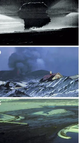
During the eleven centuries of settlement in Iceland volcanic activity has repeatedly affected the popula-tion, directly and indirectly, and sometimes with ex-treme severity. Eruptions and events directly related to volcanic and geothermal activity commonly occur and their consequences range from direct impact of incandescent tephra or lava to jökulhlaups and con-tamination of air, water and crops (Figure 1). For the most part Iceland is sparsely populated with no per-manent settlements in the interior highlands.
Popula-tion clusters mainly occur along the coast, with about 70% of the 300 thousand inhabitants living in the greater Reykjavík area and along the southern shore of Faxaói Bay in southwest Iceland. The Reykjavík metropolitan area is located just outside the margins of the active volcanic zone and the occurrence of vol-canic eruptions inside the Reykjavík area is therefore considered remote although its southern and eastern-most parts are susceptible to lava ows from future eruptions.
Figure 1. Examples of hazards caused by volcanic activity in Iceland: (a) The 28 km high plinian eruption column of Hekla in 1947. Photo: Sæmundur Þórðarson. (b) Burial of part of the town of Vestmannaeyjar in lava and tephra by the Eldfell eruption in 1973. Photo: Sigurður Thorarinsson. (c) a jökulhlaup caused by the Gjálp eruption in 1996 destroy-ing one of the bridges on Highway 1 on Skeiðarársandur outwash plain. –(a) Gosmökkur í Heklugosinu 1947, 28 km hár, teygir sig til suðurs í átt að Fljótshlíðinni; (b) Stór hluti húsanna í Vestmannaeyjum grófst í gjósku í gosinu 1973; (c) Grímsvatnahlaup sem kom í kjölfar Gjálpargossins haustið 1996 tók af brúna á Gígjukvísl og skemmdi stóran hluta ve-garins yr Skeiðarársand.
Moderately populated areas are located close to very active volcanic centres in south, southeast and northeast Iceland. Major eruptions (∼ 2–20 km3 DRE) occur every few hundred years and have ma-jor regional effects which in some cases in the past, as in Laki 1783–84, caused famine in Iceland and had a marked temporal effect on climate in the north-ern hemisphere (e.g. Thorarinsson, 1974a; Thordar-son and Self, 2003). In recent decades, explosive eruptions have posed a threat to aviation trafc in the busy routes between Europe and North America and East Asia.
The aim of this paper is to present a brief overview of the principal types of volcanic hazard in Iceland with special emphasis on the time since settlement (last∼1130 years), the damage and loss due to vol-canic activity in recent decades, the present state of hazard awareness and future prospects.
GEOLOGICAL SETTING –
CHARACTERISTICS OF VOLCANISM
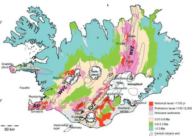
Volcanic activity in Iceland is conned to the active volcanic zones (Figure 2) The zones are composed of volcanic systems which usually consist of a cen-tral volcano and assure swarm that may extend tens of kilometres along strike in both directions away from the central volcano. Out of the 30 identied volcanic systems (Thordarson and Larsen, 2007), 16 have been active after 870 AD (Table 1). Most erup-tions occur within central volcanoes, with Grímsvötn, Hekla and Katla having the highest eruption frequen-cies (Table 1) and together with their associated ss-sure systems they have the highest volcanic produc-tivity (Thordarson and Larsen, 2007). The central vol-canoes have often developed calderas that frequently host active geothermal systems, and erupt a range of magma compositions from basalts to rhyolites al-though basalts or basaltic andesites are usually vol-umetrically dominant in the their products (e.g. Sæ-mundsson, 1979; Jakobsson, 1979; Thordarson and Larsen, 2007). In many central volcanoes typical eruptions are small (<0.1 km3DRE) although in his-torical times eruptions in both Hekla and Katla have frequently been considerably larger. Eruptions on theFigure 2. Simplied geological map of Iceland showing historical and Holocene lava ows, glaciers, and the main chronologically-dened units. Modied from Jóhannesson and Saemundsson (1998). – Einfaldað jarðfræðikort af Íslandi. Á kortinu sjást nýleg hraun (rauð og bleik) og helstu jarðsögulegu einingar landsins.
ssure swarms produce basalts. They are less fre-quent but tend to be larger than eruptions conned to the central volcanoes, with volcanic ssures extend-ing up to several tens of kilometres. Some of the largest known eruptions in Iceland are of this type. Examples are the Laki eruption in 1783 and the Eldgjá eruption of 934, both of which erupted well in excess of 10 km3 DRE (Table 1). It should be noted that the four largest effusive eruptions account for over 50% of the total magma volume emitted in historical time (see Thordarson and Larsen, 2007 and references therein). Many of the largest volcanic events areres: a series of eruptions occurring along the samessure over a period of several months or years. Basalts ac-count for 79% of the total of the 87 km3DRE erupted in Iceland in the last 1130 years, with intermediate
compositions accounting for 16% and silicic erup-tions for 5% (Thordarson and Larsen, 2007). Erup-tions have occurred in Iceland on average once every 3–4 years over the last 4 centuries (Thordarson and Larsen, 2007). The recurrence time of eruptions of different sizes and severity is summarized in Table 2. The eruption size frequencies are based on published data on eruption sizes (Thordarson and Larsen, 2007 and references therein). The bulk volume of pyroclas-tic deposits (Thorarinsson, 1958, 1967, 1975; Larsen, 1984, 2000; Thordarson and Larsen, 2007 and refer-ences therein) is used as a basis for the the recurrence times of eruptions with different VEI values.
Explosive eruptions and explosive phases of mixed eruptions are basically of two categories, mag-matic eruptions where the explosive fragmentation is
Figure 1. Examples of hazards caused by volcanic activity in Iceland: (a) The 28 km high plinian eruption column of Hekla in 1947. Photo: Sæmundur Þórðarson. (b) Burial of part of the town of Vestmannaeyjar in lava and tephra by the Eldfell eruption in 1973. Photo: Sigurður Thorarinsson. (c) a jökulhlaup caused by the Gjálp eruption in 1996 destroy-ing one of the bridges on Highway 1 on Skeiðarársandur outwash plain. –(a) Gosmökkur í Heklugosinu 1947, 28 km hár, teygir sig til suðurs í átt að Fljótshlíðinni; (b) Stór hluti húsanna í Vestmannaeyjum grófst í gjósku í gosinu 1973; (c) Grímsvatnahlaup sem kom í kjölfar Gjálpargossins haustið 1996 tók af brúna á Gígjukvísl og skemmdi stóran hluta ve-garins yr Skeiðarársand.
Moderately populated areas are located close to very active volcanic centres in south, southeast and northeast Iceland. Major eruptions (∼ 2–20 km3 DRE) occur every few hundred years and have ma-jor regional effects which in some cases in the past, as in Laki 1783–84, caused famine in Iceland and had a marked temporal effect on climate in the north-ern hemisphere (e.g. Thorarinsson, 1974a; Thordar-son and Self, 2003). In recent decades, explosive eruptions have posed a threat to aviation trafc in the busy routes between Europe and North America and East Asia.
The aim of this paper is to present a brief overview of the principal types of volcanic hazard in Iceland with special emphasis on the time since settlement (last∼1130 years), the damage and loss due to vol-canic activity in recent decades, the present state of hazard awareness and future prospects.
GEOLOGICAL SETTING –
CHARACTERISTICS OF VOLCANISM
Volcanic activity in Iceland is conned to the active volcanic zones (Figure 2) The zones are composed of volcanic systems which usually consist of a cen-tral volcano and assure swarm that may extend tens of kilometres along strike in both directions away from the central volcano. Out of the 30 identied volcanic systems (Thordarson and Larsen, 2007), 16 have been active after 870 AD (Table 1). Most erup-tions occur within central volcanoes, with Grímsvötn, Hekla and Katla having the highest eruption frequen-cies (Table 1) and together with their associated ss-sure systems they have the highest volcanic produc-tivity (Thordarson and Larsen, 2007). The central vol-canoes have often developed calderas that frequently host active geothermal systems, and erupt a range of magma compositions from basalts to rhyolites al-though basalts or basaltic andesites are usually vol-umetrically dominant in the their products (e.g. Sæ-mundsson, 1979; Jakobsson, 1979; Thordarson and Larsen, 2007). In many central volcanoes typical eruptions are small (<0.1 km3DRE) although in his-torical times eruptions in both Hekla and Katla have frequently been considerably larger. Eruptions on theFigure 2. Simplied geological map of Iceland showing historical and Holocene lava ows, glaciers, and the main chronologically-dened units. Modied from Jóhannesson and Saemundsson (1998). –Einfaldað jarðfræðikort af Íslandi. Á kortinu sjást nýleg hraun (rauð og bleik) og helstu jarðsögulegu einingar landsins.
ssure swarms produce basalts. They are less fre-quent but tend to be larger than eruptions conned to the central volcanoes, with volcanic ssures extend-ing up to several tens of kilometres. Some of the largest known eruptions in Iceland are of this type. Examples are the Laki eruption in 1783 and the Eldgjá eruption of 934, both of which erupted well in excess of 10 km3 DRE (Table 1). It should be noted that the four largest effusive eruptions account for over 50% of the total magma volume emitted in historical time (see Thordarson and Larsen, 2007 and references therein). Many of the largest volcanic events areres: a series of eruptions occurring along the samessure over a period of several months or years. Basalts ac-count for 79% of the total of the 87 km3DRE erupted in Iceland in the last 1130 years, with intermediate
compositions accounting for 16% and silicic erup-tions for 5% (Thordarson and Larsen, 2007). Erup-tions have occurred in Iceland on average once every 3–4 years over the last 4 centuries (Thordarson and Larsen, 2007). The recurrence time of eruptions of different sizes and severity is summarized in Table 2. The eruption size frequencies are based on published data on eruption sizes (Thordarson and Larsen, 2007 and references therein). The bulk volume of pyroclas-tic deposits (Thorarinsson, 1958, 1967, 1975; Larsen, 1984, 2000; Thordarson and Larsen, 2007 and refer-ences therein) is used as a basis for the the recurrence times of eruptions with different VEI values.
Explosive eruptions and explosive phases of mixed eruptions are basically of two categories, mag-matic eruptions where the explosive fragmentation is
Table 1. Volcanic systems in Iceland where eruptions have occurred after∼870 AD –Eldstöðvakersem gosið hafa eftir að landið byggðist (eftir∼870).
Volcano/ Conf. Most Magma Largest Largest Principal hazards Volcanic system eruptions recent prod. since explosive effusive
Since eruption ∼870 AD eruption eruption ∼870 AD DRE (km3)
Katla 21 1918 25 934 934 Jökulhlaups
(1, 2) VEI 5 18 km3 Tephra fall
Lavaows
Grímsvötn ∼70 2004 21 1783 1783 Jökulhlaups
Laki VEI 4 14 km3 Lavaows
(1, 3) Tephra fall
Hekla 23 2000 13 1104 1766–68 Tephra fall
(4, 1) VEI 5 1.3 km3 Lavaows
Fluorosis Bárðarbunga- 23 1910? 10 1477 Pre 12th Tephra fall
Veiðivötn VEI 5–6 century Jökulhlaups
(1, 5) 5 km3 Lavaows
Öræfajökull 2 1727 2 1362 – Pyroclasticows
(6) VEI 6 Jökulhlaups/lahars
Tephra fall Askja >two 1961 >1.5* 1875 uncertain Tephra fall
(7, 1) episodes VEI 5
Kraa two 1984 0.5 – 1984 Lavaow
(8, 9) episodes ∼0.1 km3
Eyjafjallajökull 3 1821–23 <0.1 1821–23 ∼920 Jökulhlaups/lahars
(10) VEI 2 0.05 km3 Tephra fall
Vestmannaeyjar 2 1973 ≥1.2 1963–64 1964–67# Tephra fall
(11, 12) VEI 3 1 km3 Lavaow
Reykjanes four ∼1340? 3 – ∼1227 Lavaow
Peninsula (four episodes 0.3 km3 Tephra fall
volc. systems) (13, 14)
Prestahnúkur 1 ∼950 8 – ∼950 Lavaow
system (1) 8 km3
Þeistareykir - 1 1867 ? VEI 2? – Tephra fall
submarine part (15)
Snæfellsnes (16) 1 ∼900 0.2 – ∼900 Lavaow
0.2 km3 Tephra fall
* Values highly uncertain. #: Volume applies to whole Surtsey eruption, both explosive and effusive phases. References: (1) Thordarson
and Larsen (2007), (2) Larsen (2000); (3) Larsen (2002); (4) Thorarinsson (1967); (5) Larsen (1984); (6) Thorarinsson (1958); (7) Tho-rarinsson (1944, 1963); (8) Sæmundsson (1991); (9) Rossi (1997); (10) Gudmundssonet al.(2005); (11) Jakobsson (1979), (12) Mattsson and Höskuldsson (2003); (13) Jónsson (1983); (14) Einarsson and Jóhannesson (1989); (15) Thorarinsson (1965); (16) Jóhannesson (1978). primarily caused by the expansion of magmatic gases
and phreatomagmatic eruptions where fragmentation results from magma-water interaction. In Iceland, by far the greatest majority of explosive events are phreatomagmatic explosive basaltic eruptions. These occur in volcanic systems that are partly covered by ice caps such as the Grímsvötn and Katla volcanoes, have high groundwater level (e.g. the Veiðivötnssure swarm), or are situated on the continental shelf (like
Vestmannaeyjar). Plinian, subplinian and phreato-plinian explosive events producing andesitic, dacitic or rhyolitic tephra are less common but constitute 24 of about 150 known explosive or partly explosive eruptions since AD 870. They have, however, gen-erally wider aerial dispersal and more poisonous ef-fects than the phreatomagmatic eruptions; mainly due to halogens adhering to the tephra (Thordarson and Larsen, 2007; Larsen and Eiríksson, this volume).
Table 2. Recurrence times, magnitude and severity of eruptions in Iceland. (a) Recurrence times - eruption
magnitude. –Tíðni og stærð eldgosa á Íslandi. VDRE Recurrence time
km3 Years <0.01 5–10 0.01–0.05 5–10 0.05–0.1 10 0.1–0.5 10–20 0.5–1.0 50 1–5 100 5–10 500 >10 500–1,000
(b) Recurrence times of eruptions of Volcanic
Explosivity Index 1–6.
VEI Recurrence time Years 1 10 2 10 3 10–20 4 30–50 5 100–200 6 500–1,000
The high frequency of eruptions within glaciers in Iceland implies that some common terms used to de-scribe explosive eruptions such as the Volcanic Explo-sivity Index (VEI) can give misleading information on the true magnitude or impact of events. For example,
the Gjálp eruption in 1996 produced only∼0.01 km3 of airborne tephra and no lava. Yet it was the fourth largest eruption in Iceland in the 20th century but with the bulk of the material deposited subglacially (Gud-mundssonet al., 1997). A similar argument can be ap-plied to the Katla eruption in 1918 where a large part of the erupted material was water-transported tephra
(Larsen, 2000; Tómasson, 1996). Hence, the volume
of meltwater (about 4 km3for Gjálp) may be a useful indicator of magnitude in subglacial eruptions.
Short term warning of an impeding eruption is at present based on short term seismic precursors. These are usually intense swarms of earthquakes in the hours before the onset of an eruption. The start of an erup-tion often distinguishes itself on seismic records as a sudden drop in frequency and magnitude of earth-quakes and the onset of continuous seismic tremor (e.g. Einarsson, 1991a, 1991b; Soosaluet al., 2005). All conrmed eruptions since 1996 have been
pre-dicted on the basis of such seismic activity.
The most severe volcanic eruptions in Iceland are the dominantly effusiveood basalt eruptions reach-ing a volume of 20 km3DRE, and plinian eruptions
with a VEI of 6 (bulk volume of tephra≥10 km3). Evidence for explosive eruptions reaching VEI 7 and VEI 8 has not been discovered in the geological record of Iceland.
MAIN TYPES OF VOLCANIC HAZARDS
Tephra falloutThe factors inuencing tephra dispersal can broadly be divided into those governed by the type, intensity and magnitude of the eruption, including height of the eruption column and the duration of the eruption, and those governed by external factors such as wind strength, wind direction and changes in wind direction during an eruption. The location of a volcano relative to inhabited areas is also important with respect to po-tential hazards from tephra fallout.
Tephra fallout from plinian and subplinian erup-tion columns, normally lasting an hour to several hours, is most often conned to relatively narrow sectors but tephra thickness within these sectors can reach tens of cm in proximal areas (Figure 3). Phreatomagmatic basaltic eruptions aressure erup-tions that generally last days or weeks and although the tephra is dispersed from lower eruption columns, changing wind directions can increase the area af-fected by the fallout due to the longevity of the erup-tions.
Hekla volcano, located at the northeast margin
of the Southern lowlands, is characterised by erup-tions having a subplinian to plinian opening phase with tephra volumes ranging from 0.1 to 2 km3 of
Table 1. Volcanic systems in Iceland where eruptions have occurred after∼870 AD –Eldstöðvakersem gosið hafa eftir að landið byggðist (eftir∼870).
Volcano/ Conf. Most Magma Largest Largest Principal hazards Volcanic system eruptions recent prod. since explosive effusive
Since eruption ∼870 AD eruption eruption ∼870 AD DRE (km3)
Katla 21 1918 25 934 934 Jökulhlaups
(1, 2) VEI 5 18 km3 Tephra fall
Lavaows
Grímsvötn ∼70 2004 21 1783 1783 Jökulhlaups
Laki VEI 4 14 km3 Lavaows
(1, 3) Tephra fall
Hekla 23 2000 13 1104 1766–68 Tephra fall
(4, 1) VEI 5 1.3 km3 Lavaows
Fluorosis Bárðarbunga- 23 1910? 10 1477 Pre 12th Tephra fall
Veiðivötn VEI 5–6 century Jökulhlaups
(1, 5) 5 km3 Lavaows
Öræfajökull 2 1727 2 1362 – Pyroclasticows
(6) VEI 6 Jökulhlaups/lahars
Tephra fall Askja >two 1961 >1.5* 1875 uncertain Tephra fall
(7, 1) episodes VEI 5
Kraa two 1984 0.5 – 1984 Lavaow
(8, 9) episodes ∼0.1 km3
Eyjafjallajökull 3 1821–23 <0.1 1821–23 ∼920 Jökulhlaups/lahars
(10) VEI 2 0.05 km3 Tephra fall
Vestmannaeyjar 2 1973 ≥1.2 1963–64 1964–67# Tephra fall
(11, 12) VEI 3 1 km3 Lavaow
Reykjanes four ∼1340? 3 – ∼1227 Lavaow
Peninsula (four episodes 0.3 km3 Tephra fall
volc. systems) (13, 14)
Prestahnúkur 1 ∼950 8 – ∼950 Lavaow
system (1) 8 km3
Þeistareykir - 1 1867 ? VEI 2? – Tephra fall
submarine part (15)
Snæfellsnes (16) 1 ∼900 0.2 – ∼900 Lavaow
0.2 km3 Tephra fall
* Values highly uncertain. #: Volume applies to whole Surtsey eruption, both explosive and effusive phases. References: (1) Thordarson
and Larsen (2007), (2) Larsen (2000); (3) Larsen (2002); (4) Thorarinsson (1967); (5) Larsen (1984); (6) Thorarinsson (1958); (7) Tho-rarinsson (1944, 1963); (8) Sæmundsson (1991); (9) Rossi (1997); (10) Gudmundssonet al.(2005); (11) Jakobsson (1979), (12) Mattsson and Höskuldsson (2003); (13) Jónsson (1983); (14) Einarsson and Jóhannesson (1989); (15) Thorarinsson (1965); (16) Jóhannesson (1978). primarily caused by the expansion of magmatic gases
and phreatomagmatic eruptions where fragmentation results from magma-water interaction. In Iceland, by far the greatest majority of explosive events are phreatomagmatic explosive basaltic eruptions. These occur in volcanic systems that are partly covered by ice caps such as the Grímsvötn and Katla volcanoes, have high groundwater level (e.g. the Veiðivötnssure swarm), or are situated on the continental shelf (like
Vestmannaeyjar). Plinian, subplinian and phreato-plinian explosive events producing andesitic, dacitic or rhyolitic tephra are less common but constitute 24 of about 150 known explosive or partly explosive eruptions since AD 870. They have, however, gen-erally wider aerial dispersal and more poisonous ef-fects than the phreatomagmatic eruptions; mainly due to halogens adhering to the tephra (Thordarson and Larsen, 2007; Larsen and Eiríksson, this volume).
Table 2. Recurrence times, magnitude and severity of eruptions in Iceland. (a) Recurrence times - eruption
magnitude. –Tíðni og stærð eldgosa á Íslandi. VDRE Recurrence time
km3 Years <0.01 5–10 0.01–0.05 5–10 0.05–0.1 10 0.1–0.5 10–20 0.5–1.0 50 1–5 100 5–10 500 >10 500–1,000
(b) Recurrence times of eruptions of Volcanic
Explosivity Index 1–6.
VEI Recurrence time Years 1 10 2 10 3 10–20 4 30–50 5 100–200 6 500–1,000
The high frequency of eruptions within glaciers in Iceland implies that some common terms used to de-scribe explosive eruptions such as the Volcanic Explo-sivity Index (VEI) can give misleading information on the true magnitude or impact of events. For example,
the Gjálp eruption in 1996 produced only∼0.01 km3 of airborne tephra and no lava. Yet it was the fourth largest eruption in Iceland in the 20th century but with the bulk of the material deposited subglacially (Gud-mundssonet al., 1997). A similar argument can be ap-plied to the Katla eruption in 1918 where a large part of the erupted material was water-transported tephra
(Larsen, 2000; Tómasson, 1996). Hence, the volume
of meltwater (about 4 km3for Gjálp) may be a useful indicator of magnitude in subglacial eruptions.
Short term warning of an impeding eruption is at present based on short term seismic precursors. These are usually intense swarms of earthquakes in the hours before the onset of an eruption. The start of an erup-tion often distinguishes itself on seismic records as a sudden drop in frequency and magnitude of earth-quakes and the onset of continuous seismic tremor (e.g. Einarsson, 1991a, 1991b; Soosaluet al., 2005). All conrmed eruptions since 1996 have been
pre-dicted on the basis of such seismic activity.
The most severe volcanic eruptions in Iceland are the dominantly effusiveood basalt eruptions reach-ing a volume of 20 km3DRE, and plinian eruptions
with a VEI of 6 (bulk volume of tephra ≥10 km3). Evidence for explosive eruptions reaching VEI 7 and VEI 8 has not been discovered in the geological record of Iceland.
MAIN TYPES OF VOLCANIC HAZARDS
Tephra falloutThe factors inuencing tephra dispersal can broadly be divided into those governed by the type, intensity and magnitude of the eruption, including height of the eruption column and the duration of the eruption, and those governed by external factors such as wind strength, wind direction and changes in wind direction during an eruption. The location of a volcano relative to inhabited areas is also important with respect to po-tential hazards from tephra fallout.
Tephra fallout from plinian and subplinian erup-tion columns, normally lasting an hour to several hours, is most often conned to relatively narrow sectors but tephra thickness within these sectors can reach tens of cm in proximal areas (Figure 3). Phreatomagmatic basaltic eruptions are ssure erup-tions that generally last days or weeks and although the tephra is dispersed from lower eruption columns, changing wind directions can increase the area af-fected by the fallout due to the longevity of the erup-tions.
Hekla volcano, located at the northeast margin
of the Southern lowlands, is characterised by erup-tions having a subplinian to plinian opening phase with tephra volumes ranging from 0.1 to 2 km3 of
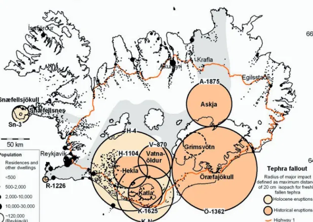
Figure 3. Areas that may receive over 20 cm of tephra fall in major explosive eruptions are indicated with circles around volcanoes orssure swarms where explosive activity is common or the dominant mode of activity. The radius of each circle is dened as the distance to the 20 cm isopach along the axis of thickness for the largest historical and prehistoric explosive eruptions of each volcano. Also shown are populated areas and the main route, Highway 1. The volcanic zones are shown with a shade of gray. –1. Svæði þar sem gjóskufall getur orðið 20 cm eða meira í miklum sprengigosum eru sýnd með hringjum utan um eldstöðvarnar. Geisli hvers hrings ákvarðast af mestu fjarlægð til 20 cm jafnþykktarlínu fyrir stærstu þekkt gos í hverri eldstöð á sögulegum og forsögulegum tíma. Á kortinu sjást einnig byggð svæði og þjóðvegur 1.
uncompacted tephra (VEI indices 3–5). The largest of the 18 Hekla eruptions of the last millennium, in 1104, deposited a 20 cm thick tephra layer 30 km from Hekla and devastated farms up to 70 km from the volcano. The largest plinian eruption of the last millennium (VEI 6) which produced about 10 km3 of uncompacted tephra, occurred in 1362 at the ice capped Öræfajökull volcano located in the middle of the Öræ district in South East Iceland (Thorarins-son, 1958). The inhabited area at the base of the
volcano and stretching eastward along the coast to Hornafjörður was devastated by tephra fallout. The tephra reached a thickness of ≥1 m some ∼15 km from source. Furthermore the immediate surround-ings of Öræfajökull where affected by jökulhlaups, and pyroclastic ows and surges (see below). The plinian eruption of Askja in 1875, which produced 2 km3bulk volume, caused abandonment of farms in the highlands 60–70 km away from the volcano (Tho-rarinsson, 1944; Sparkset al., 1981).
The majority of the phreatomagmatic eruptions during the last millennium occurred on the ice-covered parts of the Grímsvötn system with the heav-iest tephra fall within the∼8000 km3Vatnajökull ice
cap. Tephra fallout causing problems in farming ar-eas occurred only during the largest events (VEI 4), e.g. the Grímsvötn eruptions of 1619, 1873 and 1903. Eruptions in the subglacial Katla volcano have caused much more damage than those within Vatnajökull. The upper slopes of Katla volcano are covered by the 600 km3 Mýrdalsjökull ice cap and the lowlands to its west, south and east are partly inhabited. Depend-ing on wind direction durDepend-ing large eruptions (VEI 4) inhabited areas have been subjected to heavy tephra fall, such as up to 20 cm at distances of 30 km (Figure 3). However, the largest phreatomagmatic eruptions (VEI 5) are those occurring on longssures in areas of high ground water or below ice, such as the∼870 AD Vatnaöldur and∼934 AD Eldgjá eruptions (see Figs. 2 and 3 for location). Although the 20 cm isopachs do not extend signicantly farther from source than the those of smaller (VEI 4) eruptions (Figure 3), the area within that isopach is an order of magnitude larger, e.g. 240 km2and 1600 km2for K–1625 and V
∼870 tephra layers, respectively (Larsen, 1984, 2000).
The moderate-sized explosive eruptions that have occurred in recent decades have produced eruption plumes rising to 8–15 km. As a result eruption plumes have repeatedly caused temporal disruption to air traf-c within Iceland and in parts of the North Atlantic. Over the last 20 years this occurred in 1991, 1996, 1998, 2000 and 2004 (e.g. Höskuldssonet al., 2007; Vogfjördet al., 2005).
Lightning
Lightning is common in phreatomagmatic eruption columns. In the past lightning has been a threat to livestock and people during Katla eruptions due to the volcano’s proximity to populated areas, resulting in two fatalities at a farm 30 km from Katla in 1755 (Safn til sögu Íslands IV; 1907–1915). No reliable numbers exist for loss of livestock although it is often men-tioned in accounts of eruptions of Katla. Even though lightning is also common during the more frequent Grímsvötn eruptions, they have posed much less of
threat due to the location of Grímsvötn far from pop-ulated areas and the moderate size of past eruptions. Pollution
Chemical compounds adhering to the surface of tephra particles can cause pollution of water supplies and grazing lands in areas remote to the erupting vol-canoes. Hekla magma is rich in halogens, in partic-ular uorine. Fluorosis, poisoning of grazing live-stock, has been reported in almost all Hekla eruptions where adequate records exist. Mass death of trout in lakes 110 km from Hekla in 1693 was attributed to tephra fallout. Fluorosis poisoning in livestock and humans was also reported from the Laki eruption in 1783 (D’Alessandro 2006, Steingrímsson 1998). The most pronounced atmospheric pollution from an Ice-landic eruption occurred in the largeood basalt erup-tions of Eldgjá 934 and Laki 1783. The former re-leased some 220 Mt of SO2 and the latter about 120 Mt. (Thordarsonet al., 1996, 2001). The resulting haze that accompanied the Laki eruption was noted in Europe in the summer of 1783 (Thordarsonet al., 1996). In Iceland the poisoning led to ill health of the population, decimation of livestock and a subse-quent famine that killed thousands of people (Tho-rarinsson, 1974a). Studies in Europe suggests that the haze contributed to unusually high mortality in Eng-land and France in 1783–1784 (Grattanet al., 2003a, 2003b, 2005; Courtillot, 2005; Witham and Oppen-heimer, 2005).
Pyroclastic density currents
Due to the primarily basaltic nature of Icelandic vol-canism, pyroclastic density currents are not promi-nent. However, major ignimbrites and minor pyro-clasticow deposits have formed throughout the ge-ological history of Iceland within central volcanoes erupting evolved magma. Several are found within the Tertiary formations (Walker, 1959, 1962, 1963) notably the Skessa Tuff. In western Iceland the ig-nimbrite in Húsafell is well known (Sæmundsson and Noll, 1974). Only three examples are known from the Quaternary Period (<1.8 Ma), the Halarauður tuff from Kraa volcano (Sæmundsson, 1991), the ∼55,000 year old Þórsmörk ignimbrite from Tind-fjallajökull volcano (Lacasse and Garbe-Schönberg,
Figure 3. Areas that may receive over 20 cm of tephra fall in major explosive eruptions are indicated with circles around volcanoes orssure swarms where explosive activity is common or the dominant mode of activity. The radius of each circle is dened as the distance to the 20 cm isopach along the axis of thickness for the largest historical and prehistoric explosive eruptions of each volcano. Also shown are populated areas and the main route, Highway 1. The volcanic zones are shown with a shade of gray. –1. Svæði þar sem gjóskufall getur orðið 20 cm eða meira í miklum sprengigosum eru sýnd með hringjum utan um eldstöðvarnar. Geisli hvers hrings ákvarðast af mestu fjarlægð til 20 cm jafnþykktarlínu fyrir stærstu þekkt gos í hverri eldstöð á sögulegum og forsögulegum tíma. Á kortinu sjást einnig byggð svæði og þjóðvegur 1.
uncompacted tephra (VEI indices 3–5). The largest of the 18 Hekla eruptions of the last millennium, in 1104, deposited a 20 cm thick tephra layer 30 km from Hekla and devastated farms up to 70 km from the volcano. The largest plinian eruption of the last millennium (VEI 6) which produced about 10 km3 of uncompacted tephra, occurred in 1362 at the ice capped Öræfajökull volcano located in the middle of the Öræ district in South East Iceland (Thorarins-son, 1958). The inhabited area at the base of the
volcano and stretching eastward along the coast to Hornafjörður was devastated by tephra fallout. The tephra reached a thickness of ≥1 m some ∼15 km from source. Furthermore the immediate surround-ings of Öræfajökull where affected by jökulhlaups, and pyroclastic ows and surges (see below). The plinian eruption of Askja in 1875, which produced 2 km3bulk volume, caused abandonment of farms in the highlands 60–70 km away from the volcano (Tho-rarinsson, 1944; Sparkset al., 1981).
The majority of the phreatomagmatic eruptions during the last millennium occurred on the ice-covered parts of the Grímsvötn system with the heav-iest tephra fall within the∼8000 km3Vatnajökull ice
cap. Tephra fallout causing problems in farming ar-eas occurred only during the largest events (VEI 4), e.g. the Grímsvötn eruptions of 1619, 1873 and 1903. Eruptions in the subglacial Katla volcano have caused much more damage than those within Vatnajökull. The upper slopes of Katla volcano are covered by the 600 km3 Mýrdalsjökull ice cap and the lowlands to its west, south and east are partly inhabited. Depend-ing on wind direction durDepend-ing large eruptions (VEI 4) inhabited areas have been subjected to heavy tephra fall, such as up to 20 cm at distances of 30 km (Figure 3). However, the largest phreatomagmatic eruptions (VEI 5) are those occurring on longssures in areas of high ground water or below ice, such as the∼870 AD Vatnaöldur and∼934 AD Eldgjá eruptions (see Figs. 2 and 3 for location). Although the 20 cm isopachs do not extend signicantly farther from source than the those of smaller (VEI 4) eruptions (Figure 3), the area within that isopach is an order of magnitude larger, e.g. 240 km2and 1600 km2 for K–1625 and V
∼870 tephra layers, respectively (Larsen, 1984, 2000).
The moderate-sized explosive eruptions that have occurred in recent decades have produced eruption plumes rising to 8–15 km. As a result eruption plumes have repeatedly caused temporal disruption to air traf-c within Iceland and in parts of the North Atlantic. Over the last 20 years this occurred in 1991, 1996, 1998, 2000 and 2004 (e.g. Höskuldssonet al., 2007; Vogfjördet al., 2005).
Lightning
Lightning is common in phreatomagmatic eruption columns. In the past lightning has been a threat to livestock and people during Katla eruptions due to the volcano’s proximity to populated areas, resulting in two fatalities at a farm 30 km from Katla in 1755 (Safn til sögu Íslands IV; 1907–1915). No reliable numbers exist for loss of livestock although it is often men-tioned in accounts of eruptions of Katla. Even though lightning is also common during the more frequent Grímsvötn eruptions, they have posed much less of
threat due to the location of Grímsvötn far from pop-ulated areas and the moderate size of past eruptions. Pollution
Chemical compounds adhering to the surface of tephra particles can cause pollution of water supplies and grazing lands in areas remote to the erupting vol-canoes. Hekla magma is rich in halogens, in partic-ular uorine. Fluorosis, poisoning of grazing live-stock, has been reported in almost all Hekla eruptions where adequate records exist. Mass death of trout in lakes 110 km from Hekla in 1693 was attributed to tephra fallout. Fluorosis poisoning in livestock and humans was also reported from the Laki eruption in 1783 (D’Alessandro 2006, Steingrímsson 1998). The most pronounced atmospheric pollution from an Ice-landic eruption occurred in the largeood basalt erup-tions of Eldgjá 934 and Laki 1783. The former re-leased some 220 Mt of SO2and the latter about 120 Mt. (Thordarson et al., 1996, 2001). The resulting haze that accompanied the Laki eruption was noted in Europe in the summer of 1783 (Thordarsonet al., 1996). In Iceland the poisoning led to ill health of the population, decimation of livestock and a subse-quent famine that killed thousands of people (Tho-rarinsson, 1974a). Studies in Europe suggests that the haze contributed to unusually high mortality in Eng-land and France in 1783–1784 (Grattanet al., 2003a, 2003b, 2005; Courtillot, 2005; Witham and Oppen-heimer, 2005).
Pyroclastic density currents
Due to the primarily basaltic nature of Icelandic vol-canism, pyroclastic density currents are not promi-nent. However, major ignimbrites and minor pyro-clasticow deposits have formed throughout the ge-ological history of Iceland within central volcanoes erupting evolved magma. Several are found within the Tertiary formations (Walker, 1959, 1962, 1963) notably the Skessa Tuff. In western Iceland the ig-nimbrite in Húsafell is well known (Sæmundsson and Noll, 1974). Only three examples are known from the Quaternary Period (<1.8 Ma), the Halarauður tuff from Kraa volcano (Sæmundsson, 1991), the ∼55,000 year old Þórsmörk ignimbrite from Tind-fjallajökull volcano (Lacasse and Garbe-Schönberg,
Figure 4. Hekla and surroundings. The extent of his-torical lavas and the maximum extent of pyroclastic ows during 20th century eruptions is shown (circle). – Útbreiðsla hrauna frá Heklu á sögulegum tíma og mesta fjarlægð sem gjóskuóð hafa náð út frá eld-stöðinni á 20. öld (sýnd með hring).
Figure 5. Öræfajökull and surroundings. The cir-cle denes the maximum extent of pyroclasticows using the observed runout length of such ows to-wards the south and the west in the 1362 eruption. The dark arrows show conrmed pathways of jökul-hlaups in 1362 while the light arrows indicate sus-pected pathways (Thorarinsson,1958; Höskuldsson and Thordarson, unpublished data). –Öræfajökull og nágrenni. Geisli hringsins miðast við mestu fjarlægð sem gjóskuóð runnu út frá fjallinu til suðurs og ves-turs í gosinu 1362. Dökku örvarnar sýna staðfestar leiðir jökulhlaupa í gosinu 1362 en þær ljósu líklegar hlaupleiðir.
2001) and the Sólheimar ignimbrite from Katla vol-cano (Jónsson, 1987) dated at 12,171±114 ice core years (Rasmussen et al., 2006). The apparent lack of preserved silicic pyroclastic ow deposits during the Quaternary Period in Iceland may be a result of heavy glaciation. Firstly, during glacial periods the pyroclasts may have been deposited on glaciers and therefore not preserved. Secondly, glacial erosion may have removed interglacially-formed pyroclastic deposits.
The opening phase of the subplinian Hekla 2000 eruption generated several small pyroclasticows that
extended up to 5 km from the vent (Höskuldssonet al., 2007). Similarly the subplinian eruption of Hekla in 1980 generated pyroclasticows (Figure 4). The plinian Hekla eruption in 1947 may have generated several pyroclastic ows and some quite extensive, however, the deposits were rst interpreted as be-ing jökulhlaup and mudow deposits (Kjartansson, 1951; Höskuldsson, 1999). The plinian Askja erup-tion in 1875 was accompanied by pyroclastic surges that where conned to the main Askja caldera (Sparks et al., 1981). The most violent eruption during his-torical time in Iceland is that of Öræfajökull in 1362.
Contemporaneous annals simply state that the district as a whole was laid waste but later annals indicate that the entire population of about 30 farms at the foot of the volcano perished in the eruption (Figure 5). Re-cent re-examination of the deposits has revealed that several pyroclasticows and surges where generated at the beginning of the eruption (Höskuldsson and Thordarson, 2007), possibly supporting the annals’ information that nobody survived. These recent stud-ies have therefore revealed that pyroclasticow de-posits are common in historical plinian and subplinian eruptions in Iceland.
Although pyroclasticows can be the most dev-astating and deadly hazard in explosive eruptions, the probability of such events reaching inhabited areas in Iceland is low. The highest probability of this oc-curring applies to Snæfellsjökull, Eyjafjallajökull and Öræfajökull. Although the Holocene eruption fre-quency of these volcanoes has been quite low (erup-tion interval of order 1000 years) this threat cannot be ignored.
Lavaows
Postglacial lava ows cover large parts of the vol-canic zones. Many of these are 8000–10000 year old, formed in a surge of activity following the deglacia-tion at the end of the Weichselian glaciadeglacia-tion (e.g. Maclennan et al., 2002). This includes the large lava shields which have volumes ranging from 1 to 20 km3 (Rossi, 1996; Gudmundsson, 2000). Lava ows formed in historical times (Figure 6) cover 3300 km2. Small volume lavas are conned to the volcanic systems and central volcanoes, while the larger vol-ume lavas canow for tens of kilometers away from the source into areas outside the active volcanic zones (Thordarson and Larsen, 2007). The rate of advance of lava is relatively slow except close to vent or for lava formed at very high eruption rate. Risk of fa-talities in effusive eruptions is therefore low. Prop-erty loss has been frequent in Icelandic effusive erup-tions, especially when eruption occurs close to inhab-ited areas. Examples of loss of property are the Eldgjá eruption in 934, the Hekla eruptions, in particular the eruption of 1389, the Laki eruption in 1783, the Mý-vatnres in 1724–29 and the eruption of Heimaey in 1973 (Landnámabók, 1968; Thorarinsson 1967, 1979;
Einarsson, 1974). Hazard of future effusive eruptions owing into populated areas in Iceland is relatively high and increasing considering the growing popula-tion of the island; of special concern are the south-ern suburbs of Reykjavík, Grindavík on the Reykjanes Peninsula, the town of Heimaey, the Mývatn district and the populated lowland around Snæfellsjökull. Jökulhlaups
The most common hazards related to volcanic and geothermal activity in Iceland are frequent jökul-hlaups, the majority coming from the glaciers of Vatnajökull and Mýrdalsjökull (Katla) (Figures 2 and 7). Most of these events are water ows although they may often carry a heavy load of sediments and sometimes ice blocks (e.g. Tómasson, 1996) and un-less otherwise stated the term jökulhlaup is here used for suchows. However, occasionally theoods may be lahars (hyperconcentrated or debrisows). In his-torical times substantial jökulhlaups have originated in the central volcanoes or associatedssure swarms of Grímsvötn, Katla, Öræfajökull, Bárðarbunga, Eyja-fjallajökull, Þórðarhyrna and the subglacial geother-mal area of Skaftárkatlar in northwest Vatnajökull (e.g. Thorarinsson, 1958, 1974b; Björnsson, 2003; Tómasson, 1996; Larsen, 2000; Ísaksson, 1984; Gud-mundssonet al., 2005; Gröndal and Elefsen, 2005). Two main types of volcano-related jökulhlaups occur. Firstly, where the meltwater is produced in volcanic eruptions by release of thermal energy from rapidly cooling volcanic material as in Katla 1918 and Gjálp 1996. Secondly, where subglacial geothermal areas continuously melt the ice, the meltwater accumulates in a subglacial lake and is then drained at semi-regular intervals when lake level exceeds some critical value (Björnsson, 2003). This latter type tends to be smaller and is much more common. Jökulhlaups also occur from ice-dammed lakes without any volcanic involve-ment. These are usually much smaller than jökul-hlaups due to subglacial volcanic eruptions and will not be considered further here.
The Katla jökulhlaups have been preceded by earthquakes 2–10 hours before the oodwater emerges from the glacier (Safn til sögu Íslands, 1907– 1915; Gudmundsson et al., 2005). A large Katla jökulhlaup as in 1918 may reach peak discharge of
Figure 4. Hekla and surroundings. The extent of his-torical lavas and the maximum extent of pyroclastic ows during 20th century eruptions is shown (circle). – Útbreiðsla hrauna frá Heklu á sögulegum tíma og mesta fjarlægð sem gjóskuóð hafa náð út frá eld-stöðinni á 20. öld (sýnd með hring).
Figure 5. Öræfajökull and surroundings. The cir-cle denes the maximum extent of pyroclasticows using the observed runout length of such ows to-wards the south and the west in the 1362 eruption. The dark arrows show conrmed pathways of jökul-hlaups in 1362 while the light arrows indicate sus-pected pathways (Thorarinsson,1958; Höskuldsson and Thordarson, unpublished data). –Öræfajökull og nágrenni. Geisli hringsins miðast við mestu fjarlægð sem gjóskuóð runnu út frá fjallinu til suðurs og ves-turs í gosinu 1362. Dökku örvarnar sýna staðfestar leiðir jökulhlaupa í gosinu 1362 en þær ljósu líklegar hlaupleiðir.
2001) and the Sólheimar ignimbrite from Katla vol-cano (Jónsson, 1987) dated at 12,171±114 ice core years (Rasmussen et al., 2006). The apparent lack of preserved silicic pyroclastic ow deposits during the Quaternary Period in Iceland may be a result of heavy glaciation. Firstly, during glacial periods the pyroclasts may have been deposited on glaciers and therefore not preserved. Secondly, glacial erosion may have removed interglacially-formed pyroclastic deposits.
The opening phase of the subplinian Hekla 2000 eruption generated several small pyroclasticows that
extended up to 5 km from the vent (Höskuldssonet al., 2007). Similarly the subplinian eruption of Hekla in 1980 generated pyroclasticows (Figure 4). The plinian Hekla eruption in 1947 may have generated several pyroclasticows and some quite extensive, however, the deposits were rst interpreted as be-ing jökulhlaup and mudow deposits (Kjartansson, 1951; Höskuldsson, 1999). The plinian Askja erup-tion in 1875 was accompanied by pyroclastic surges that where conned to the main Askja caldera (Sparks et al., 1981). The most violent eruption during his-torical time in Iceland is that of Öræfajökull in 1362.
Contemporaneous annals simply state that the district as a whole was laid waste but later annals indicate that the entire population of about 30 farms at the foot of the volcano perished in the eruption (Figure 5). Re-cent re-examination of the deposits has revealed that several pyroclasticows and surges where generated at the beginning of the eruption (Höskuldsson and Thordarson, 2007), possibly supporting the annals’ information that nobody survived. These recent stud-ies have therefore revealed that pyroclastic ow de-posits are common in historical plinian and subplinian eruptions in Iceland.
Although pyroclasticows can be the most dev-astating and deadly hazard in explosive eruptions, the probability of such events reaching inhabited areas in Iceland is low. The highest probability of this oc-curring applies to Snæfellsjökull, Eyjafjallajökull and Öræfajökull. Although the Holocene eruption fre-quency of these volcanoes has been quite low (erup-tion interval of order 1000 years) this threat cannot be ignored.
Lavaows
Postglacial lava ows cover large parts of the vol-canic zones. Many of these are 8000–10000 year old, formed in a surge of activity following the deglacia-tion at the end of the Weichselian glaciadeglacia-tion (e.g. Maclennan et al., 2002). This includes the large lava shields which have volumes ranging from 1 to 20 km3 (Rossi, 1996; Gudmundsson, 2000). Lava ows formed in historical times (Figure 6) cover 3300 km2. Small volume lavas are conned to the volcanic systems and central volcanoes, while the larger vol-ume lavas canow for tens of kilometers away from the source into areas outside the active volcanic zones (Thordarson and Larsen, 2007). The rate of advance of lava is relatively slow except close to vent or for lava formed at very high eruption rate. Risk of fa-talities in effusive eruptions is therefore low. Prop-erty loss has been frequent in Icelandic effusive erup-tions, especially when eruption occurs close to inhab-ited areas. Examples of loss of property are the Eldgjá eruption in 934, the Hekla eruptions, in particular the eruption of 1389, the Laki eruption in 1783, the Mý-vatnres in 1724–29 and the eruption of Heimaey in 1973 (Landnámabók, 1968; Thorarinsson 1967, 1979;
Einarsson, 1974). Hazard of future effusive eruptions owing into populated areas in Iceland is relatively high and increasing considering the growing popula-tion of the island; of special concern are the south-ern suburbs of Reykjavík, Grindavík on the Reykjanes Peninsula, the town of Heimaey, the Mývatn district and the populated lowland around Snæfellsjökull. Jökulhlaups
The most common hazards related to volcanic and geothermal activity in Iceland are frequent jökul-hlaups, the majority coming from the glaciers of Vatnajökull and Mýrdalsjökull (Katla) (Figures 2 and 7). Most of these events are water ows although they may often carry a heavy load of sediments and sometimes ice blocks (e.g. Tómasson, 1996) and un-less otherwise stated the term jökulhlaup is here used for suchows. However, occasionally theoods may be lahars (hyperconcentrated or debrisows). In his-torical times substantial jökulhlaups have originated in the central volcanoes or associatedssure swarms of Grímsvötn, Katla, Öræfajökull, Bárðarbunga, Eyja-fjallajökull, Þórðarhyrna and the subglacial geother-mal area of Skaftárkatlar in northwest Vatnajökull (e.g. Thorarinsson, 1958, 1974b; Björnsson, 2003; Tómasson, 1996; Larsen, 2000; Ísaksson, 1984; Gud-mundssonet al., 2005; Gröndal and Elefsen, 2005). Two main types of volcano-related jökulhlaups occur. Firstly, where the meltwater is produced in volcanic eruptions by release of thermal energy from rapidly cooling volcanic material as in Katla 1918 and Gjálp 1996. Secondly, where subglacial geothermal areas continuously melt the ice, the meltwater accumulates in a subglacial lake and is then drained at semi-regular intervals when lake level exceeds some critical value (Björnsson, 2003). This latter type tends to be smaller and is much more common. Jökulhlaups also occur from ice-dammed lakes without any volcanic involve-ment. These are usually much smaller than jökul-hlaups due to subglacial volcanic eruptions and will not be considered further here.
The Katla jökulhlaups have been preceded by earthquakes 2–10 hours before the oodwater emerges from the glacier (Safn til sögu Íslands, 1907– 1915; Gudmundsson et al., 2005). A large Katla jökulhlaup as in 1918 may reach peak discharge of
Figure 6. Historical lavaows in Iceland (age less than 1130 years). The volcanic zones are shown with a shade of gray. –Hraun sem runnið hafa á Íslandi á sögulegum tíma (á síðustu 1130 árum).
300,000 m3/s and inundate an area of 600–800 km2 to the east of the volcano (Tómasson, 1996; Larsen, 2000). The short warning time puts severe strain on civil defence authorities as only about 1–1.5 hours are available to close roads and evacuate areas poten-tially at risk. Recent studies (Smith, 2004; Larsenet al., 2005) show that during the Holocene, large Katla jökulhlaups have on averageowed towards the west once every 500–800 years. Simulations indicate that a westwardowing jökulhlaup of the same magnitude as the 1918 jökulhlaup would inundate an area of 600 km2with a population close to 600 (Elíassonet al., 2007). Water depths exceeding 1 m andow veloci-ties >1 m/s are predicted over most of the populated part of the inundated area. Jökulhlaups from Katla issued directly towards the south around the time of
settlement some 1100 years ago. The onset of a Katla eruption therefore calls for evacuation of a large area on both the west and east side of the volcano, and over a limited area on its south side. Figure 8 shows the results of simulations of propagation times and inun-dation areas for jökulhlaups towards the west, south and east. The great hazard posed by Katla has led to special monitoring with seismometers, continuously recording GPS, radio-linked river gauges, regular air-borne radar proling and inspectionights of the ice cap (e.g. Gudmundssonet al., 2007). Most of these data can be viewed in real time on the internet through the web-pages of the Icelandic Meteorological Ofce, the Hydrological Survey and the Institute of Earth Sci-ences, University of Iceland.
Figure 7. Areas affected by jökulhlaups attributed to volcanic activity in Iceland during the Holocene. Over the last 1130 years the most severely and frequently impacted areas have been Mýrdalssandur east of Katla and Skeiðarársandur, southeast of Vatnajökull. The box indicates the area shown on Figure 8. The volcanic zones are shown with a shade of gray. –Svæði sem jökulhlaup hafa farið yr á Íslandi á síðustu 10.000 árum. Síðan land byggðist hafa stór hlaup einkum farið um Skeiðarársand og Mýrdalssand.
Jökuhlaups from Grímsvötn are either geothermal or eruption-induced, with the latter type usually be-ing much larger but less frequent. A frequent size of geothermal jökulhlaups in the latter half of the 20th century was 1,000–10,000 m3/s (Gudmundsson et al., 1995) while the jökulhlaup caused by the Gjálp eruption in 1996 reached 45,000 m3/s (Björnsson, 2003). The high frequency of Grímsvötn jökulhlaups has made Skeiðarársandur, the pathway of the jök-ulhlaups, uninhabitable. Volcanic jökulhlaups may, however, overow and damage Highway 1 and in that way block the main transportation route in southeast Iceland. Smaller jökulhlaups caused by geothermal activity can issue from various places in the
west-ern part of Vatnajökull and Mýrdalsjökull (Katla) but these are usually relatively minor. The eruptions in Öræfajökull in 1362 and 1727 caused jökulhlaups or lahars that swept down the steep slopes of the volcano and issued from outlet glaciers. The 1727 oods claimed three lives, one of the surprisingly rare recorded fatalities associated with jökulhlaups (Tho-rarinsson, 1958). In the 1362 eruption, major jökul-hlaups occurred, perhaps partly caused by fallout or density currents of hot tephra on glaciers in the steep mountain slopes. These may have played an impor-tant role in destroying the district around Öræfajökull volcano, formerly known as Litla Hérað.
Figure 8. The inundated areas and predicted propagation times for jökulhlaups of peak discharge 250,000– 300,000 m3/s arising from eruptions within the ice-covered Katla caldera. Although jökulhlaups from all three outlets are shown on the map, the probability of majoroods issuing during the same eruption down more than one of the threeood routes is small. –Útbreiðslusvæði og reiknaðir útbreiðslutímar jökulhlaupa vegna eldgosa innan Kötluöskjunnar. Á myndinni eru sýnd þrjú tilfelli (hlaup um Kötlujökul, Entujökul og
Sólheima-jökul). Gert er ráð fyrir hámarksrennslinu 250.000–300.000 m3/s í hverju tilfelli. Líkur á að hlaup af þessu tagi komi fram áeiri en einum stað á sama tíma eru hverfandi.
Other hazards
Hazards not listed above include earthquakes, fault-ing, damming of rivers by lava ows or tephra, and tsunamis. These events can be regarded as infre-quent or minor compared to those discussed earlier. Seismic activity associated with eruptions is usually not of sufcient magnitude to be the cause of ma-jor damage although the seismic precursors are one of the most important warning signs of an imminent eruption (e.g. Einarsson, 1991b; Gudmundssonet al., 2005). Since eruptions sometimes occur during ma-jor rifting episodes, faulting may damage roads and buildings. The largessure eruptions of Vatnaöldur in 870 AD and Veiðivötn in 1477 AD caused damming of the river Tungnaá and subsequentooding (Larsen, 1984). Minor tsunamis have occurred, related to jök-ulhlaups from Katla and Grímsvötn (e.g. Thorarins-son, 1975). These events were somewhat delayed in relation to the oods, suggesting that they resulted
from submarine slumping of unstable sediments car-ried to the ocean by theoods.
DAMAGE AND LOSS DUE TO
VOLCANIC HAZARD
There is evidence to suggest that weather-related events (storms, blizzards, heavy seas, snow avalanches etc.) have claimed the largest number of lives of any hazards in Iceland (Jóhannesson, 2001). In comparison, the volcanic death toll is considerably smaller. However, when it comes to the potential severity of single events, the largest volcanic erup-tions (e.g. Laki 1783, Öræfajökull 1362) dwarf events caused by other natural hazards. The prospects for fa-talities in volcanic eruptions have, however, changed considerably over the last 100 years or so. The main reason for fatalities in conjunction with volcanic erup-tions in Iceland has been famine caused by crop
fail-ure or loss of livestock as a result of tephra fallout and uorine poisoning (Table 3). By far the most
severe recorded event was the famine in 1784–1785
following the Laki eruption. Records are incomplete but other eruptions where contemporary sources in-dicate famine include the Hekla eruptions of 1104 and 1300, and famine is also suspected for the Eldgjá eruption in 934. Major loss of livestock is recorded
for eruptions from Hekla in 1510, 1693 and 1766–68
(Thorarinsson, 1974a). The total loss of life cannot be estimated with any accuracy from pre-18th century records, but the number of fatalities is probably well over 10,000. Major loss of life is suspected for the
Öræfajökull 1362 eruption. However, conrmed fa-talities from reasons other than post-eruption famine are surprisingly few. Only two fatalities occurred
in the 20th century (Jóhannesson, 2001) despite the Heimaey eruption in January 1973 when the volcanic
ssure was located just 200 m east of the town with over 5000 inhabitants. Had thessure opened up 500
m further to the west, considerable loss of life would have been unavoidable.
Although post-eruption famine is a remote prospect today, damage to infrastructure and the eco-nomical consequences of eruptions can be severe for a nation of only 300,000 people. Roads, communica-tion and power lines cross knownoodpaths of major jökulhlaups from Grímsvötn and Katla and geother-mal power plants can by necessity be located on or immediately adjacent to central volcanoes. Some losses are therefore inevitable in the future as in the past. The economic losses resulting from volcanic eruptions since 1970 are outlined in Table 4. These are minimum estimates since any loss to private and public businesses due to inconveniences caused by these events are not listed and neither are costs due to rerouting of aircraft during eruptions. The total loss due to volcanic events over the last 37 years amounts
to approximately 180 million euro or about 5 million
euro on average per year. Two events stand out, the Heimaey eruption in 1973 and the accumulated loss in production in the Kraa power plant.
DISCUSSION
During medieval times and the Little Ice Age, the community in Iceland was poor and relied mostly on subsistence farming. Hence, loss of life due to famine as a result of volcanic eruptions could be very severe as outlined above. Considering the technological and economical advancement over the last 100 years, such fatalities are extremely unlikely in present-day Ice-land. Moreover, the increasingly sophisticated warn-ing systems, notably the real time seismic network, hold great prospects of advance warning for most vol-canic eruptions. Infrequent, high magnitude events,
such as the Öræfajökull eruption of 1362 could today, as in 1362, nevertheless cause major damage and loss
of life if affected areas could not be evacuated in time. The opening of a volcanicssure within a town, as al-most happened in Vestmannaeyjar in 1973, could have catastrophic consequences. With increased tourism, active volcanoes that often have erupted explosively in the past have become popular destinations for hikers and other travellers. Hekla in particular, has erupted every 10 years over the last 40 years and is infamous for the very short duration of seismic precursors prior to eruptions. Therefore the prospect of fatalities in the beginning subplinian phase of a future Hekla eruption are rising.
The prospects for severe loss of property and other economic damage are considerable. Moderate ef-fusive eruptions on the Reykjanes peninsula, as
oc-curred several times in the 10th–13th century AD
(Ta-ble 1) can in future produce lavaows that can reach the shore on either side of the peninsula. Hundreds of residential homes, key transportation routes and important industrial estates could be lost as a result. Awareness of this potent threat, together with appro-priate planning and location of future residential and industrial areas is essential to minimise this risk. Sim-ilar arguments apply to pathways of past catastrophic jökulhlaups west of Katla. Sensible planning of areas close to the Katla volcano is the key issue to minimize risk to life and limit economic damage. In the case of future eruptions of Katla the loss of parts of Highway 1 is anticipated as well as possible damage to compo-nents of communication and power transmission sys-tems from lightning.