Soil Erosion in a Highly Dynamic,
Terraced Environment
The Effect of the Three Gorges Dam in China
Dissertation
der Mathematisch-Naturwissenschaftlichen Fakultät der Eberhard Karls Universität Tübingen
zur Erlangung des Grades eines Doktors der Naturwissenschaften
(Dr. rer. nat.)
vorgelegt von
Diplom Geographin Sarah Schönbrodt-Stitt aus Eberswalde
Tübingen 2013
Tag der mündlichen Prüfung: 29. April 2014
Dekan: Prof. Dr. Wolfgang Rosenstiel
Erster Gutachter: Prof. Dr. Thomas Scholten Zweiter Gutachter: Prof. Dr. Gerhard Gerold
Global land lost to soil erosion in the first half of the year 2013
(January 1st to July 1st, 2013)
2,912,287 HECTARES
LIST OF CONTENT
List of Content ..………... I List of Figures ………... IV List of Tables ………. VI Abbreviations ………. VII Preface ………... IXChapter 1 Introduction and State of the Art ……….. 1
1.1 Soil Erosion in the Global Context ……….. 1
1.1.1 The Natural Geomorphic Process of Soil Erosion ... 1
1.1.2 The Anthropogenic-induced Acceleration of Soil Erosion ... 2
1.1.3 Farming Terraces as Key Soil Conservation Technology ... 3
1.1.4 Figures and Effects of Soil Erosion ... 5
1.2 Soil Erosion in China ………... 7
1.2.1 Soil Erosion in the Upper Yangtze River Basin ……….. 8
1.2.2 Soil Erosion in the Three Gorges Area ……… 11
1.2.2.1 Land Use Changes in the Three Gorges Area ……….. 11
1.2.2.2 Current Status of Soil Erosion in the Three Gorges Area ……... 13
1.2.2.3 Ecological Implications of Soil Erosion in the Three Gorges Area ……….. 14 1.2.2.4 Need for Enhanced Understanding of Soil Erosion in the Three Gorges Area……… 14 Chapter 2 Starting Points of the Research and Objectives ………... 18
3.1 Study Framework ……….... 20
3.2 Study Area ……….... 20
3.2.1 Geographical Position and Study Scales ……….... 20
3.2.2 Climate in the Xiangxi Catchment ……….... 22
3.2.3 Terrain and Geology in the Xiangxi Catchment ………... 23
3.2.4 Soils and Soil Erodibility in the Xiangxi Catchment ………... 24
3.2.5 Land Use and Land Use Change in the Xiangxi Catchment ……….... 26
3.3 Geodatabase ………... 32
3.4 Soil Erosion Modeling ………... 35
3.4.1 The Revised Universal Soil Loss Equation ………..…………... 36
3.4.2 Model Parameterization ………..……….... 38
Chapter 4 Overview on the Manuscripts ……….... 42
4.1 Soil Erosion in the Mountainous Catchment of the Xiangxi River ... 42
4.2 Assessing the USLE Crop and Management Factor C for Soil Erosion Modelling in a Large Mountainous Watershed in Central China ... 45 4.3 Approximation and Spatial Regionalization of Rainfall Erosivity Based on Sparse Data in a Mountainous Catchment of the Yangtze River in Central China …... 48 4.4 Degradation of Cultivated Bench Terraces in the Three Gorges Area - Field Mapping and Data Mining ... 53 Chapter 5 Conclusions and Outlook ...……….... 62
Chapter 6 Summary ………... 72
Chapter 6 Zusammenfassung ………... 75
Annex ………... 100
Annex I China’s History of Human-Induced Soil Erosion ……….... 100
Annex II China’ Efforts on Combating Soil Erosion ……….. 101
Annex III The Yangtze River ……….... 103
Annex IV On Large Dam Projects and their Effect on Soil Erosion ………….... 104
Annex V The Three Gorges Dam and its Reservoir ………... 106
Manuscripts ………. 108
Manuscript 1: GIS-based Assessment and Analysis of Soil Erosion by Water in the Three Gorges Ecosystem, original title: GIS-basierte Erfassung und Analyse der Bodenerosion durch Wasser im Drei-Schluchten-Ökosystem ….. 108 Manuscript 2:Assessing the USLE Crop and Management Factor C for Soil Erosion Modelling in a Large Mountainous Watershed in Central China ….... 165 Manuscript 3: Approximation and Spatial Regionalization of Rainfall Erosivity based on Sparse Data in a Mountainous Catchment of the Yangtze River in Central China ………. 180 Manuscript 4: Degradation of Cultivated Bench Terraces in the Three Gorges Area – Field Mapping and Data Mining …………... 213 Acknowledgments ………... 253 Curriculum Vitae ………... XI Scientific Publications, Books, and Conference Contributions ...………... XIII Declaration by the Candidate ………………...... XVIII
LIST OF FIGURES
Figure 1 Water erosion vulnerability in China, in the Yangtze River Basin, and in the Upper Yangtze River Basin ………...………....
Figure 2 Impoundment of the Yangtze River by the Three Gorges Dam in the surrounding of the dam before the flooding in 1993 and after the flooding in 2009 ...………...
Figure 3 Challenging location of housing and farmland on frequently steep to very steep slopes in the Three Gorges Area as observed in a large mountainous catchment of a first class tributary to the Yangtze River …………...
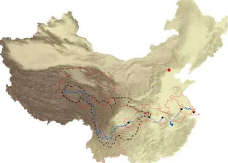
Figure 4 Location of the Xiangxi catchment in the Upper Yangtze River Basin in China and in the western Hubei province with the counties Shennongjia, Xingshan, and Zigui. Geo-graphical position of the Xiangxi catchment and its range of elevation. Slope angles in the Backwater area with the sub-catchments Xiangjiaba and Quyuan ………....
Figure 5 Climate diagram for Xingshan station in the central Xiangxi catchment with long-term average monthly temperature (°C) and precipitation (mm) from 1961 to 1990 ...
Figure 6 The Xiangxi River, and the alternation of the Triassic formation exhibiting extreme slope lengths and the less steep sloping and morphological softer Jurassic formation in the Backwater area of the Xiangxi catchment ...……….………...
Figure 7 Spatial distribution of the major soil groups in the Xiangxi catchment based on the Chinese Second National Soil Survey. Spatial distribution of the soil erodibility (t ha h ha-1 MJ-1 mm-1) based on the major soil groups in the Xiangxi catchment ………...
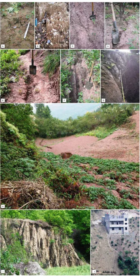
Figure 8 Soil erosion in the Xiangxi catchment ………... Figure 9 Diversity of farming bench terraces in the Xiangxi catchment on hillsides sloping with more than 5° ...
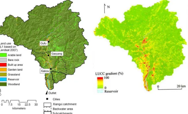
Figure 10 Land use classification in the Xiangxi catchment based on Landsat-TM 2007 and gradient on the land use and land cover change (LUCC) on the catchment scale from 1987 to 2007 ………...………
Figure 11 Land use dynamic in the Xiangxi catchment associated with the impoundment of the Yangtze River by the Three Gorges Dam .……...………...……...
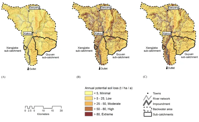
Figure 12 Potential annual average soil loss (t ha-1 a-1) under natural conditions (A), under former land use in 1987 (B), and under recent land use in 2007 (C) in the Backwater area with the sub-catchments Quyuan and Xiangjiaba. The modeled soil erosion is classified according to the Technological Standard of Soil and Water Conservation SD238-87 issued by the Ministry of Water Resources ...
Figure 13 Spatial distribution of R factors in the Xiangxi catchment based on mean annual R factors according to MEN ET AL. (2008). R factors are in SI unit (MJ mm ha-1 h-1 a-1) ...
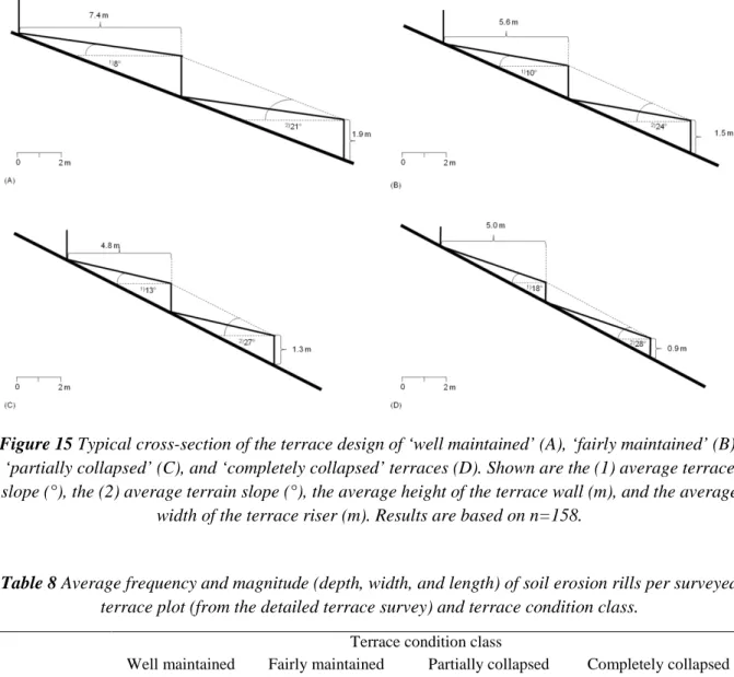
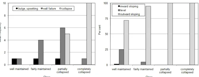
Figure 14 Model framework of TerraCE ... Figure 15 Typical cross-section of the terrace design of ‘well maintained’, ‘fairly main-tained’, ‘partially collapsed’, and ‘completely collapsed’ terraces. Shown are the (1) average terrace slope (°), the (2) average terrain slope (°), the average height of the terrace wall (m), and the average width of the terrace riser (m) ...
Figure 16 Average frequency of wall disorders in each terrace condition class (A). Due to few observations of bulges and upsetting these wall disorders are grouped into one category. Percentage of different sloping terrace risers in each terrace condition class (B) ...
Figure 17 The river course of the Yangtze and the Upper Yangtze River Basin with the borders of the provinces where the Yangtze River mainly passes through and the largest cities Chongqing, Yichang, Wuhan, Nanjing, and Shanghai ...
Figure 18 Global spatial distribution of large dam projects by country ... Figure 19 The Three Gorges Dam in 2008 and the sediment-choked, impounded Yangtze River right upstream the dam in 2010 ...
Figure 20 Location of the Three Gorges Dam close to Yichang at the outlet of the Upper Yangtze River Basin and the newly created Three Gorges Reservoir after river impoundment in 2007 upstream from Yichang towards Chongqing, and design of the scheduled water levels ...
LIST OF TABLES
Table 1 Available data sources for soil erosion modeling in the Xiangxi catchment and their spatial resolution and applicability as well as references of use in the studies conducted within the framework of the present thesis ...
Table 2 Geographical position (UTM WGS 1984, Zone 49 N; X = Northing, Y = Easting), elevation, and length of daily rainfall records of the climate stations in the Xiangxi catchment and its surrounding area ...
Table 3 C factor values for model parameterization of the RUSLE for the land use in the Xiangxi catchment ...
Table 4 Average annual soil losses (t ha-1 a-1) by water erosion under natural conditions and under land use in 1987 and 2007 in the Xiangxi catchment and the sub-units considered ...
Table 5 Multi-temporal analysis of the fractional vegetation cover (FVC) in percent and of C factors (dimensionless) derived from FVC (CFVC) from 2005 to 2007 compared to C factors (dimensionless) taken from literature (CLIT) based on the land use classification from 2007 ....
Table 6 Annual average soil loss potential (t ha-1 a-1) in the Xiangxi catchment and in the subunits for the years 2005, 2006, and 2007 (all for September) ...
Table 7 Approximated R factors (MJ mm ha-1 h-1 a-1) for the Xiangxi catchment calculated from 1971 to 2000 based on regression equations ...
Table 8 Average frequency and magnitude (depth, width, and length) of soil erosion rills per surveyed terrace plot (from the detailed terrace survey) and terrace condition class ...
Table 9 The 30 out of 81 most important indicators in predicting the terrace condition classes Table 10 Areas (in 10³ km²) of soil erosion and soil erosion control in the Upper Yangtze River Basin and Yangtze River Basin from 1951 to 2002 ………...
ABBREVIATIONS
BMBF German Federal Ministry of Education and Research
MEP Ministry of Environmental
Protection of the People's Republic of China
BMP Best Management Practice MLR Ministry of Land and Resources of
the People’s Republic of China CSTC Chinese Soil Taxonomic
Classification
NMIC National Meteorological Information Centre of China CUG China University of Geosciences NDVI Normalized Differenced
Vegetation Index CYJV Canadian Yangtze Joint Venture Pd Precipitation per day
DEM Digital Elevation Model Ra Mean annual R factor
EUROSEM European Soil Erosion Model RD Relieving and De-farming mode FAO Food and Agriculture Organization
of the United Nations
RS Remote sensing
FONA BMBF Framework Programme
'Research for Sustainable Development'
RTD Rebuilding Terrace and De-farming mode
Fmod Modified Fournier Index RUSLE Revised Universal Soil Loss
Equation
FVC Fractional Vegetation Cover SEPA State Environmental Protection Administration
GFG Grain for Green Programme SNSS Second National Soil Survey in China
GIS Geographic Information System SP Subproject
ICOLD International Commission on Large Dams
SRTM Shuttle Radar Topographic Mission
IECA International Erosion Control Association
TerraCE Terrace-Condition-Erosion model
ISWM Integrated Small Watershed Management
TGR Three Gorges Reservoir
IUCN International Union for Conservation of Nature
TGA Three Gorges Area
LUCC Land use and land cover change TGD Three Gorges Dam
MAP Mean annual precipitation USDA U.S. Department for Agriculture USLE Universal Soil Loss Equation
UYR Upper Yangtze River UYRB Upper Yangtze River Basin YRB Yangtze River Basin
WCD World Commission on Dams
WEPP Water Erosion Prediction Project WMO World Meteorological Organization WSC Water and soil conservation
WSCL Water and Soil Conservation Law WRB World Reference Base
PREFACE
The dissertation entitled "Soil Erosion in a Highly Dynamic, Terraced Environment - Effect of the Three Gorges Dam in China" was developed by the author as a cumulative thesis at the Chair of Physical Geography and Soil Science, Department of Geosciences at the University of Tübingen. It is submitted for the degree of Doctor of Natural Sciences.
The thesis is part of an interdisciplinary joint research project aiming at the ecological consequences of the changing environmental conditions in the newly created reservoir of the Three Gorges Area at the Yangtze River in Central China. The results presented herein required comprehensive field surveys, data analysis and modeling using Geographical Information Systems and data mining approaches, and laboratory analyses. Based on those, one book chapter and three peer-reviewed articles dealing with the impact of the Three Gorges Dam on the risk potential of soil erosion by water and the modification of the bench terraces, i.e., terraced degradation, as the most important soil conservation measure in the study area, were published. As a mismatch between existing data and data required as input for soil erosion modeling constrained the study, the research herein is largely based on remote sensing data serving as a fast and available supplier for the derivation of area-wide and spatially explicit data on the landscape level.
The purpose of this dissertation is to introduce and demonstrate an approach to soil erosion modeling and assessment of those processes triggering soil erosion by water in a highly dynamic, terraced environment that currently belongs to the most dynamic large-scale anthropogenic influenced and disturbed regions in the world - The Three Gorges Area. The current situation in this area highly elicits a call for action in order to control soil erosion and its slow and devastating effects. It implies the reduction of agricultural depletion and environmental risks linked to water erosion, and the contribution to ecological protection and sustainability of one of the most populated regions in China. Minimizing soil erosion through best management practices, such as well-adapted farming terraces, is an indispensable prerequisite for good soil management and includes the urgent need for understanding the processes triggering soil erosion and their spatial and temporal variability.
Therefore, this thesis combines physio-geographic and anthropo-geographic aspects to assess the relevant processes and driving forces of the soil erosion risk potential in a region undergoing high land use dynamics. The unique contribution of this thesis is the model framework TerraCE (Terrace Condition Erosion) developed for the identification and spatial analysis of different terrace conditions and their causes. It considers the sparse data availability and limited access to terrain and thus, improves the knowledge on terrace degradation by conducting the first inventory of bench terraces in the Three Gorges Area and throughout China.
Thus, this thesis might be of interest to those studying the impact of land use change in a terraced landscape in the context of soil erosion research and environmental planning as TerraCE is readily transferable to other regions when the requirements on the data are fulfilled. The thesis might also be of interest to those studying the soil erosion potential on the catchment scale of mountainous regions characterized by data scarcity.
Chapter 1 "Introduction and State-of-the-Art" spins the common thread from soil erosion in the global context to soil erosion in China and in the Three Gorges Area where the mountainous study area is located. Thus, Chapter 1 creates the basics for the derivation and for the answer of the research objectives that are presented in Chapter 2 'Staring Point of the Research and Objectives'.
Chapter 3 'Materials and Methods' introduces into the study framework and the study area and presents the geo-basis data as well as soil erosion modeling approach used.
Chapter 4 ‘Overview on the manuscripts’ explores the most relevant and intrinsic results and discussions of each study. Thereby, the overview on the manuscripts follows the chronological order regarding the date of publication of the peer-reviewed articles. Except Manuscript 1, all manuscripts were originally published in English language. They are attached in the end of this thesis as they were originally published in international peer-reviewed journals. Manuscript 1 is attached in the German language.
Chapter 5 'Conclusions and Outlook' concludes the central findings of the thesis with respect to the research objectives and issues an outlook of application possibilities of those findings and further need of research. The summary of the research is given in Chapter 6.
In Chapter 7 all references cited in the thesis are listed. Attached to this thesis, the Annex intends to provide supplementary information on the history and combat of soil erosion in China, on the Yangtze River and its Basin, as well as on the effect of large dam projects on soil erosion and technical information about the Three Gorges Dam in China. This thesis then finishes with words of thanks and appreciation addressing all persons who directly and indirectly made their part in the author’s scientific work and process and contributed to the success of the study.
The dissertation completes with the author's Curriculum Vitae, the compilation of the 'Scientific Publications, Books and Conference Contributions' that were almost exclusively conducted within the thesis framework, and the 'Declaration by the Candidate'.
This research was supported by the German Federal Ministry of Education and Research (BMBF, grant no. 03 G 0669).
1
INTRODUCTION AND STATE OF THE ART
__________________________________________________________________________________
„Should we be shocked that we are skinning our planet? Perhaps, but the evidence is everywhere. We see it in brown streams bleeding off construction sites and in sediment-choked rivers downstream from clear-cut forests. We see it where farmers’ tractors detour around gullies, where mountain bikes jump deep ruts carved into dirt roads, and where new suburbs and strip malls pave fertile valleys. This problem is no secret. Soil is our most underappreciated, least valued, and yet essential natural resource.”
David R. Montgomery, Dirt - The erosion of civilization, 2007a, p. 3 __________________________________________________________________________________
1.1 SOIL EROSION IN THE GLOBAL CONTEXT
1.1.1 THE NATURAL GEOMORPHIC PROCESS OF SOIL EROSION
Soil erosion is a natural geomorphic, interactive process involving the four stages of detachment of individual soil particles from the soil mass, their breakdown, their transport and redistribution by water and wind, and deposition with declining transport energy (LAL, 2003; MORGAN, 2005). Both, water and wind erosion are major land surface processes (BRESHEARS ET AL., 2002; ZHANG ET AL., 2011). Due to both processes generally being studied as separate and the difficulties in determining the contributing area of sediment transported by wind, the magnitude of wind erosion relative to water erosion is not fully quantified across ecosystems (ZHANG ET AL., 2011). MIDDLETON and THOMAS (1997), LAL (2001), and MORGAN (2005), however, revealed a globally higher potential and significance of water erosion. According to LAL (2001), water erosion is the biggest driver of soil degradation. At the end of the 20th century, almost 67% of the worldwide approximately 16.4 million km² of degraded soil was linked to water erosion. Wind erosion amounted to approximately 33% (LAL, 2001).
Particularly, the detachment of soil particles by raindrop impact - splash detachment - (e.g., MORGAN andNEARING, 2011; GEIßLER ET AL., 2012) and their transport downslope by overland flow are recognized as the two main driving processes of water erosion (CHORLEY, 1978; GHAHRAMANI ET AL., 2011). This soil erosion by water is referred to as 'sheet erosion' or overland flow and removes and transports detached soil in form of rainsplash, surface runoff, and shallow flows (MORGAN, 2005). Initiated by a critical distance downslope, overland flow becomes channeled as small ephemeral concentrated flow (rill erosion) or breaks up into small channels (microrill erosion). Rill erosion accounts for the most powerful erosive agent on hillsides as it is also non-selective in the particle sizes
to be transported (MOSS ET AL., 1982; MORGAN, 2005). Amongst permanent gully erosion, developing from intense soil piping typically on deeply weathered regolith or soft bedrock (HOWARD, 1999; POESEN, 2011), and interrill erosion, referring to water erosion between rills by the combined action of raindrop impact and overland flow (MORGAN, 2005), sheet and rill erosion constitute the principal mechanism of water erosion (NEARING, 1997). Factors triggering the natural process of water erosion to a varying extent dependent from their interaction are: the erosivity of the eroding agent (i.e., rainfall amount and intensity, wind speed), the erodibility referring to the soil’s resistance to particle detachment and transport, the land’s slope steepness and slope length, and the vegetation cover acting as protective layer against the erosive impact (MORGAN, 2005).
Ranging from very low soil losses up to 2 t ha-1 a-1 on relatively flat grasslands and forests to 1 to 5 t ha-1 a-1 in mountainous regions completely covered with vegetation (PATRIC, 2002 quoted in PIMENTEL, 2006), water erosion is of earth-historical relevance. In most ecosystems it normally almost equals the average rate of natural soil formation ranging from 0.5 to 1 t ha-1 a-1 (PIMENTEL and KOUNANG, 1998; WACHS and THIBAULT, 2009). The redistribution of soil and associated plant essential nutrients from weathering to depressional sites made the natural water erosion over geologic time one of the most powerful natural forces in landscape evolution (FIGUEIREDO ET AL., 1999).
Nevertheless, soil erosion in general, and water erosion in particular, is on top of the world’s agenda as one of the most pressing environmental problems of present times (HURNI ET AL., 2006). In the scientific discourse, it is even recognized as 'silent global crisis' (MONTGOMERY, 2007a) concurrent with climate change. Here, the concern is not about the natural complex system of soil erosion and its ‘long-term geological’ process (MONTGOMERY, 2007b), but rather about the accelerated soil erosion due to multiple human interferences into ecosystems and, subsequently, soil systems.
1.1.2 THE ANTHROPOGENIC-INDUCED ACCELERATION OF SOIL EROSION
Anthropogenic-induced changes in the land cover and land uses (e.g., shifts and expansion in agriculture, intensification of cultivation, deforestation and logging, urban sprawl, infrastructure construction and mega construction sites) extraordinarily alter the somewhat balanced natural system of soil loss and soil formation. On the one hand, land use is the only factor of soil erosion that can actively be modified to reduce soil loss (GILLEY, 2004). On the other hand, land use leads to accelerated soil losses that can strongly exceed the sustainable replacement rate by natural soil formation. According to BRANTLEY (2008), the human activities have globally increased the long-term soil erosion rate by a factor of approximately 30. For instance, as stated by the International Erosion Control Association (IECA, 1991) construction activities such as road and housing
construction can cause extreme short-term soil erosion ranging from 20 to 500 t ha-1 a-1 and can further enhance runoff that contributes to increased soil erosion in the long-term.
The largest and most continuous destroyer of natural soil systems and main contributor to water erosion is the agricultural production which accounts for about 75% of the worldwide soil erosion (PIMENTEL, 2006). Cropland is among those agricultural land uses that is most vulnerable (PIMENTEL, 2006). Inappropriate cropland management, such as conventional farming (e.g., row cropping, clean weeding, intensive tillage, and reduced fallow), especially enhances the effect of agriculture (MORGAN, 2005).
According to PIMENTEL (2006) and MONTGOMERY (2007a), small-scale subsistence farms in developing countries with hilly and mountainous terrain are particularly vulnerable to water erosion since they are often located on marginal land with poor soil quality and frequently steep topography. According to SOUTHGATE and WHITAKER (1992), STONE and MOORE (1997), and PIMENTEL (2006), subsistence farming is often attributed by inappropriate land management and thus, is susceptible to soil erosion. Here, the erosive effect of rainfall and terrain as well as inappropriate land management can be most effectively alleviated by establishing adequate soil conservation measures, such as sufficient crop cover, contour-aligned cultivation and planting of hedgerows, intercropping, mulching, and farming terraces (HUDSON, 1981; MORGAN, 2005). They all act as a quasi fifth factor on soil erosion in the human-induced water erosion on cropland. By reducing the terrain-induced runoff potential, especially, bench terraces are the major recommended type of soil conservation measure on sloping land (HUDSON, 1981).
1.1.3 FARMING TERRACES AS KEY SOIL CONSERVATION TECHNOLOGY
Bench terraces (synonym for slope or stone terraces) are the major recommended type of terrace for steep sloping areas (HUDSON, 1981; SHI ET AL., 2012). In order to stabilize the vertical terrace riser, dry-stone walling along the contour lines is largely applied (HUDSON, 1981; BELLIN ET AL., 2009; SHI ET AL., 2012). Since the ancient world and early modern age, terracing serves as key technology for soil and water conservation and for a suitable land management in mountainous regions throughout the world (e.g., TOY ET AL., 2002; SHRESTRA ET AL., 2004; CAO ET AL., 2007).
Due to the terracing, steep slopes are converted into an artificial sequence of relatively flat surfaces (MONTGOMERY, 2007a). The erosive slope length and angle and thus, the runoff potential distinctly decrease resulting in a reduction of terrain-induced soil erosion and sediment yield (ARNAEZ ET AL., 2010; EL ATTA and AREF, 2010; SHI ET AL., 2012).
Under optimum conditions, these engineering structures form a ‘hydraulic equilibrium’ state between the geomorphic settings and anthropogenic use (BRANCUCCI and PALIAGA, 2006; CHEMIN
and VAROTTO, 2008). From the Mediterranean, for instance, HAMMAD ET AL. (2004) report a decrease of average soil loss on bench terraces compared to non-terraced plots by factors up to 20. In the highly vulnerable Chinese Loess region, decreases of soil loss of average 49% were observed (LI and NGUYEN, 2008). Applying the WATEM/SEDEM erosion and sediment transportation model for a small watershed sloping in average with 23° in Central China, SHI ET AL. (2012) report a reduction of soil loss and sediment yield by approximately 17% and 32% for bench terraces combined with furrow-ridge tillage. Terraces are further likely to favor the interception of overland flow and to enhance the infiltration in the long-term (e.g., BELLIN ET AL., 2009; EL ATTA and AREF, 2010; SHI ET AL., 2012), to reduce the erosion-induced nutrient loss (DAMENE ET AL., 2012), to promote agricultural productivity (POSTHUMUS and STROOSNIJDER, 2010), and to expand available land for cultivation (ZHANG, 2008).
In contrast to the above benefits, numerous studies such as from Saudi Arabia (EL ATTA and AREF, 2010), the Andes in Peru (INBAR and LLERENA, 2000), from the Chinese Loess region (e.g., LI and LINDSTROM, 2001), from Italy (e.g., BAZZOFFI and GARDIN, 2011), from Greece (e.g., KOULOURI and GIOURGA, 2007), from Spain (e.g., BELLIN ET AL., 2009), Indonesia (VAN DIJK, 2002), and Thailand (SANG-ARUN ET AL., 2006) have proven that bench terraces react sensitively to changes in land use. Subsequently, despite terracing, soil erosion can be a serious problem.
Particularly, inadequate terrace design and mismanagement strongly affect the stability of bench terraces and favor soil erosion (e.g., SANG-ARUN ET AL., 2006; KOULOURI and GIOURGA, 2007; LESSCHEN ET AL., 2008; BELLIN ET AL., 2009). Causes for this phenomenon are seen in a lack of local knowledge of adequate terracing (e.g., ESTEVE ET AL., 2004), in a lack of individual farmers’ motivation and uncertainty regarding tenure (WILLIAMS, 1990; DEININGER and JIN, 2006), in a shortage of labor and investments (INBAR and LLERENA, 2000), a shift of production (BELLIN ET AL., 2009; BEVAN ET AL., 2012), and land shortage and fragmentation (CORBEELS ET AL., 2000). Mostly, these causes interact with each other and are discussed to result from an agricultural abandonment (e.g., KOULOURI and GIOURGA, 2007; LESSCHEN ET AL., 2008; EL ATTA and AREF, 2010) due to social, economic and/or political upheavals, such as rural-urban migration (e.g., AW-HASSAN ET AL., 2000; INBAR and LLERENA, 2000; KOULOURI and GIOURGA, 2007).
According to INBAR and LLERENA (2000) who studied erosional processes on bench terraces in Peru, the supporting terrace wall mainly determines the terrace stability. Typically, walls of bench terraces left to degrade exhibit bulges and upsetting by erosive action followed by more intense wall disorders such as breaches that further lead to complete collapses (INBAR and LLERENA, 2000; LASANTA ET AL., 2001; BRANCUCCI and PALIAGA, 2006; LESSCHEN ET AL., 2008; BELLIN ET AL., 2009). The natural geomorphic system will progressively annul the former balanced terraced system (BRANCUCCI and PALIAGA, 2006; BAZZOFFI and GARDIN, 2011). This will increase the slope length
and slope gradient, followed by an acceleration of runoff (e.g., EL ATTA and AREF, 2010; KOULOURI and GIOURGA, 2007). Consequently, the capability of a terrace to protect the soil against surface erosion by water is reduced, defined as terrace degradation by BAZZOFFI and GARDIN (2011).
By evaluating the potential of the terrace design to reduce soil erosion and applying flow traces, BELLIN ET AL. (2009) proved that terraces that were not longer maintained do not longer retain water and promote an increased contribution of runoff from cropland to the drainage network. Within 50 years, the portion of runoff was observed to increase from 9% to 31%. According to SIDLE ET AL. (2006) and BAZZOFFI and GARDIN (2011) poorly designed and maintained terraces represent significant sediment sources.
1.1.4 FIGURES AND EFFECTS OF SOIL EROSION
Estimated 75 billion tons of fertile soils are eroded from agricultural land each year around the world (e.g., ESWARAN ET AL., 2001; LAL, 2003; PIMENTEL, 2006; WACHS and THIBAULT, 2009). Globally, the estimated average water erosion rate on cropland is 30 t ha-1 a-1 and ranges from 0.5 to 400 t ha-1 a-1 (PIMENTEL ET AL., 1995, PIMENTEL, 2006; WACHS and THIBAULT, 2009). Thereby, highest water erosion on cropland is reported for Asia, Africa, and South America with average soil loss rates ranging from 30 to 40 t ha-1 (TADDESE 2001 quoted in PIMENTEL, 2006). In the 1990s, 105 million hectares in Europe amounting to 16 per cent of the continent's total area (without Russia) were affected by water erosion (JONES ET AL., 2012). New calculations by the Joint Research Centre of the European Union estimate the current area affected to be distinctly higher, with 1.3 million km² for the EU-27 (before EU accession of Croatia in July 2013). Approximately 20% of this area exhibits soil losses of more than 10 t ha-1 a-1 (JONES ET AL., 2012). According to PIMENTEL (2006) this severe soil erosion is directly linked to cropland and equals the average water erosion rate on cropland across the United States.
Soil erosion leads to manifold on-site and off-site disruptions that can interact with each other and can reinforce soil losses by erosive action. It affects the soil’s water storage capacity and water availability due to decreased water infiltration (e.g., PIMENTEL ET AL., 1995; JONES ET AL., 2012). The loss of soil organic matter and the subsequent loss of stable soil aggregates lead to a decline in soil porosity, again influencing slaking, infiltration, and runoff potential (PIMENTEL, 2006; BARTHÈS and ROOSE, 2002; SIX ET AL., 2002). The reduction of soil depth and disruptions in the essential plant nutrients cycle distinctly reduce the (top)soil fertility and land productivity (JONES ET AL., 2012), and considerably influence the soil biodiversity and plant diversity (e.g., PIMENTEL ET AL., 1992; HEYWOOD, 1995; JONES ET AL., 2012). This is especially true for shallow soils where water erosion may lead to an irreversible loss of the entire soil body within short erosive events (JONES ET AL., 2012) triggered by abundant rainfalls. Worldwide, the productivity loss due to soil erosion by water is
estimated to make up to 50% (ESWARAN ET AL., 2001). Particularly, African and South Asian countries are affected. Here, the average annual yield reduction by water erosion is estimated to be approximately 8%, respectively to equal to 36 million tons of cereals (ESWARAN ET AL., 2001).
Water erosion is also widely discussed to largely contribute to global warming due to releases of oxidized biomass carbon (CO2) from the soil into the atmosphere. Based on experimental analyses and national scale modeling for England and Wales, QUINTON ET AL. (2006), for instance, report the carbon that was mobilized as particulate organic matter by water erosion from cropland to range from annually 0.2 to 0.76 Mt. The losses of carbon associated to water erosion accounted for a wide range of 2 to 50% of soil carbon change (QUINTON ET AL., 2006). However, due to the complexity of soil erosion in general, its effects on C emissions and the global terrestrial carbon budget still remain not fully understood and quantifications are vague (e.g., LAL, 2003, 2004; QINTON ET AL., 2006; VAN OOST ET AL., 2007; LAL and PIMENTEL, 2008; JONES ET AL., 2012). Vice versa, future water erosion is expected to react very sensitive on climate change that will drive a 'vigorous hydrological cycle' inducing erosive torrential rainfall with higher rainfall amounts and intensities, and triggering changes in plant biomass (e.g., YANG ET AL., 2003; DUFKOVA and TOMAN, 2004¸NEARING ET AL., 2004). For instance, based on simulation studies across the United States, NEARING ET AL. (2004) predict an increase in water erosion of 1.7% for each 1% change in annual rainfall amount.
Off-site water erosion damages mainly result in and from discharge of sediments and associated contamination of waterbodies due to diffuse matter transport and particle-bounded agrochemicals from cropland (e.g., BENNETT and RHOTON, 2007). They deteriorate the quality of aquatic systems and threaten biodiversity and human health (e.g., PIMENTEL, 2006; MAINSTONE ET AL.,2008). Enormous potential of economic damages is also attributed to extreme overland flow and floods resulting from improper upstream management and from wind-driven dust storms originating from degraded land with porous vegetation (PIMENTEL ET AL., 1995; WACHS and THIBAULT, 2009).
Against the background of an increasing world population to estimated 9 billion people by the year 2050 (UNITED NATIONS, 2011), an increasing demand for food of 60 to 70% by the same year (ALEXANDRATOS and BRUINSMA, 2012), and 99.7 % of the food already coming from the land (FAO 1998 quoted in PIMENTEL, 2006), water erosion has a global significance. It constitutes a global threat to food security and drinking water quality in many parts of the world. Both, available soil resources and clean water are expected to present a future source of conflict. Thus, combating soil erosion will be a major challenge of the world community (BRADY and WEIL, 2007).
1.2 SOIL EROSION IN CHINA
Globally, China belongs to one of those countries most affected by soil erosion (HUANG, 1987; ALDHOUS, 1993; VAN LYNDEN and OLDEMANN, 1997; KOLB, 2003; HAO ET AL., 2004; WANG, 2004; CAI ET AL., 2005) and is strongly challenged with its combat. The mere fact that steeplands and shallow mountain soils, accounting for 52%, respectively 29% of China's totals (BOT ET AL., 2000), are largely linked to subtropical monsoon climate (ZHAO, 1986) already indicates a high to very high physical vulnerability to water erosion, especially, in the great river basins in north, east and central China (Figure 1). Additionally, China exhibits large regions of low to very low protective vegetation cover. This is mainly a result from former phases of development-driven deforestation and agriculturally expansion in China’s great river basins where vegetation could not completely recover through the centuries (ZHANG, 2000; c.f., Annex I).
Figure 1 Water erosion vulnerability in China, in the Yangtze River Basin, and in the Upper Yangtze River Basin (framed). (after U.S. Department of Agriculture, Natural Resources Conservation Service,
Soil Survey Division, World Soil Resources, 1998; modified).
At the same time China has the largest population in the world with a relatively high proportion of rural inhabitants (49%) and employment in agriculture of (37%; both in 2011) of nationals totals (WORLD BANK, 2013). Thus, it seems not surprising that physical vulnerability combined with population pressure on land and soil resources tremendously trigger water erosion and contribute to nationwide environmental degradation (e.g., ROZELLE ET AL., 1997; WANG, 2004; XU ET AL., 2005; TAN and GUO, 2007).
However, figures on the actual soil loss by water erosion and the area affected in China are controversial. They range from recently estimated annual 4.5 billion tons (Xinhua, 2008) to already estimated average 5.5 billion tons per year in the 1990s (e.g., LAL and STEWART, 1990; WEN, 1997;
PIMENTEL, 2006). Based on the report on land resource potential and constraints by BOT ET AL. (2000), 16% of China's territory show soil erosion risk. Based on remote-sensing based studies from the latest Chinese three-year Soil Conservation Scientific Survey, 37% to 40% of China’s territory - accounting for about 3.6 million km² - are recently classified as suffering from soil loss by water erosion (SUN ET AL., 2002; HAO ET AL., 2004; XINHUA, 2008). According to the 2013’s report by the UN Desertification Convention (UNCCD), more than 400 million people in China are directly affected by the on-site and off-site effects; such as serious losses in agricultural productivity of more than annually 20% since the 1990s (ESWARAN ET AL., 2001) and annual economic losses of estimated US$10 billion (UNCCD, 2013).
China’s severe soil erosion problem, and the anthropogenic effects triggering soil erosion and eco-environmental deterioration led to comprehensive countermeasures by the government during the second half of the 20th century (c.f., Annex II). With the nationwide implementation of the Water and Soil Conservation Law (WSCL) in 1991 and its revised version in 2011, especially the prevention and rehabilitation of land prone to water erosion were aimed. Thereby, sloping farmland or sloping land to be reclaimed for cultivation with inclinations greater than 25° is in the focus of the WSCL and prescribed as ‘reclamation-forbidden’ (LIU, 2012). The enhanced installation of conducive water erosion control measures such as farming terraces (XU ET AL., 2005) and the governmental-driven ‘Sloped Land Conversion Program’ based on the above slope steepness criterion (e.g., XU ET AL., 2006; WANG ET AL., 2007; c.f., Annex II) aimed at the distinct reduction of runoff and water erosion potential by controlling the terrain effect and converting cropland to forestland. By identifying key prevention and rehabilitation areas and implementing the Integrated Small Watershed Management (ISWM) since the 1990ies, in particular, the water-eroded, largely mountainous Yangtze River Basin became part of the governmental action plan to control soil erosion (XU ET AL., 20005; LIU, 2012; ZHU ET AL., 2013).
Notwithstanding these efforts, the Yangtze River Basin - presenting a ‘critical global ecoregion’ rich in biodiversity and one of the 35 worldwide ecological priority areas - recently shows the highest rates of soil erosion by water out of the whole of China (YIN ET AL., 2006; ZHOU, 2008; WWF China, 2013).
1.2.1 SOIL EROSION IN THE UPPER YANGTZE RIVER BASIN
Thirty-three percent (560,000 km²) of the area of the Yangtze River Basin (YRB) – the largest watershed in China – is severely affected by water erosion, mainly alongside the upper reaches of the Yangtze River (ZHOU, 2008).
Accounting for approximately 56% of the entire basin area, the mountainous Upper Yangtze River Basin (UYRB) distinctly dominates the YRB. It extends from the Qinghai Tibetan Plateau
through mountainous terrain mainly ranging between 500 and 4,000 m a.s.l. towards the plains in Central China (c.f., Annex III). Accelerated water erosion resulting from deforestation, agricultural expansion, and intensification in cropland due to industrialization and increasing population pressure, seriously affected the UYBR since the last decades (YANG ET AL., 2005; ZHANG, 2008). Within approximately 50 years, the area exhibiting water erosion dramatically increased by more than 100% from 350,000 to 711,000 km², amounting to approximately 40% of the total area of the YRB (ZHANG, 2008. Thereby, the proportion of affected area in the UYRB alone constituted more than 60 to 66% of the YRB’ total (ZHANG, 2008).
According to YANG ET AL. (2005), the area affected by water erosion positively correlated to the sediment yield during the observed period. While at the begin of the 1950s sediment deposition in reservoirs and lakes was recorded as nearly zero, the rate of deposition increased to approximately 740×106 t annually already taking into account the effect of areas under water erosion control (~35% in the YBR, ~23% in the UYBR; YANG ET AL., 2005). With an average annual sediment load of approximately 500 million tons, the UYBR accounts for the principal area of sediment production in the entire basin (DAI and TAN, 1996; YANG ET AL., 2006; ZHANG, 2008). The effect of the high soil erosion, due to inappropriate land uses and causing high deposition of sediments, and siltation of lakes and floodplains, resulted in frequent flooding and was particularly evident in 1998 and 2010 when severe flood disasters hit Hubei province (YIN and LI, 2001; LONG ET AL., 2006; PITTOCK and XU, 2011).
YANG ET AL. (2004) reported intensive and inappropriate land uses on steep slopes to be typical for the UYRB. Their effect on water erosion and sediment yield is even enhanced by abundant precipitation, erodible soil textures, and population pressure (e.g., LU and HIGGITT, 1999; ZHANG ET AL., 2002). Soil erosion by water in the UYRB affects about 35.2 million hectares accounting for approximately 63% of the entire UYRB (LONG ET AL., 2006). The total annual soil loss by water erosion in the UYRB is estimated to be 1,410 million tones with an average annual rate of water erosion of 40 t ha-1 (SHI, 1998). Thereby, sheet and rill erosion, and occasionally gully erosion constitute the major water erosion processes (LONG ET AL., 2006)
Despite the efforts on controlling soil erosion in the UYBR via key environmental programs, such as ISWM (c.f., Section 1.2), the further industrial development of the basin seems to be at odds with the general protection idea and soil conservation need.
Due to the significant elevation drop of the deeply incised Yangtze River in the UYRB (c.f., Annex III), the river has huge hydropower potential. Its usage as relevant transportation path connecting the east with the west already gave the Yangtze River an integral role in the historical development and exploitation of China (PONSETI and LÓPEZ-PUJOL, 2006). This is even more the case nowadays, since the Yangtze River plays a crucial role in the development strategic plans of the
Chinese central government (WU ET AL., 2010). These include, inter alia, the provision of electricity, goods and measures, and water to eradicate the water scarcity in North China (PONSETI and LÓPEZ -PUJOL, 2006; CHENG ET AL., 2012).
In the surrounding of major projects being economically important for the industrial development, a boost of soil erosion can be expected. Large dam projects and hydropower engineering schemes are such major projects and attract worldwide scientific and media interest due to their serious upstream and downstream environmental impacts and associated intensive land use changes (e.g., NILSSON ET AL., 2005; STONE andJIA, 2006). For instance, NORTON ET AL. (2001), COCHRANE ET AL. (2002), ALIXANDRINI (2010), ARVELA ET AL. (2012) and FERREIRA and PANAGOPOULUS (2012) could reveal a distinct raise of the soil erosion risk in the affected watersheds of the Alqueva (Portugal) and Itaipú (Brazil and Paraguay) dams due to post-construction shifts in land use and human activities (c.f., Annex IV). Both projects met unfavorable prerequisites in terms of physical vulnerability (e.g., erosion-prone soils, high rainfall erosivity, and steep terrain) and poor environment-related planning (SERAFIM ET AL., 2006; ALIXANDRINI, 2010; FERREIRA and PANAGOPOULUS, 2012). As a consequence of the increased soil erosion risk, Alqueva and Itaipú lakes are facing an accelerated sediment production and reservoir siltation leading to serious environmental and economic off-site damage (COCHRANE ET AL., 2002; FERREIRA and PANAGOPOULUS, 2012). An extreme example on the causality of 'increased soil erosion - increased sediment production - reservoir siltation' and consequently decreased lifespan of dam projects is reported from the Yellow River in China where trapped sediment behind the SanMenXia dam led to a loss of initial storage capacity within the first four years after construction (ZHU ET AL., 2013).
In the case of the UYBR, a strongly ranging number of more than 42,000 to more than 50,000 dams were already constructed from 1950 to 2003 at the Yangtze River and its tributaries (XU and MILLIMAN, 2009; YANG ET AL., 2005; YANG and LU, 2012). At present, a total of 4,688 km of streams are already regulated by dams that strongly control the discharge in the UYRB (LEHNER et al., 2011; YANG and LU, 2012), but also indicate high relevance and significance of anthropogenic-induced soil erosion in the UYRB.
Probably, the currently most prominent example on large dam projects in China and worldwide is the multipurpose Three Gorges Dam (TGD) at the Yangtze River (c.f., Annex V). It is less the dimension of the dam construction itself, but rather the short period of construction and the huge dimensions of the reservoir with a length of 660 km and a surface area of 1,084 km² (PONSETI and LÓPEZ-PUJOL, 2006) that attract worldwide scientific, societal and political interests.
1.2.2 SOIL EROSION IN THE THREE GORGES AREA
The impoundment of the Yangtze River in the zone of the ‘Three Gorges’ and further beyond towards Chongqing (c.f., Annex V) make the Three Gorges Area (TGA) the currently most dynamic large-scale anthropogenic influenced region in the world (e.g., YANG ET AL., 2002). Though the TGD project is accepted to significantly reduce China's greenhouse gases and emissions by hydropower generation (GUO, 2010), the dam is largely assumed to have negative impacts, too. Thus, the dam-induced impoundment and newly created reservoir are expected to have unprecedented long-term environmental consequences and to threaten the ecology in an unforeseeable dimension (STONE, 2008). Subsequently, expected increases in water erosion will constitute enormous environmental planning challenges in the large drainage area of the TGA of about 1 million km² (REYNOLDS, 2011; ZHU ET AL., 2013).
1.2.2.1 LAND USE CHANGES IN THE THREE GORGES AREA
Due to an enormous transformation process attributed to the construction of the TGD and ongoing associated hydraulic engineering projects after river impoundment, such as small barrages in the tributary valleys and bank reinforcement, the TGA is largely characterized by rapid land use changes. In total, an area of 635 km² has been flooded alongside the Yangtze River and its tributaries (Figure 2). Twelve counties and municipalities, and 116 cities with their whole infrastructure are affected (PONSETI and LÓPEZ-PUJOL, 2006; WU and LUO, 2006; GLEICK, 2009). Estimated 29,500 to 40,000 ha of this flooded land, accounting for about 41 to 63% of the total submerged area, was classified as agricultural land on fertile valley soils (JACKSON and SLEIGH, 2000; DAI ET AL., 2006; PONSETI and LÓPEZ-PUJOL, 2006; GLEICK, 2009).
Figure 2 Impoundment of the Yangtze River by the Three Gorges Dam, here in the surrounding of the dam before the flooding in 1993 (left) and after the flooding in 2009 (right). From GUO (2010).
The massive loss of settlements and farmland area had to be rapidly compensated. Rural and urban resettlements of more than 1.25 million people by the end of the year 2008 (MEP, 2009) and new land reclamation for the purposes of infrastructure connection and settlements as well as subsistence farming and cash crop production has taken place (MCDONALD ET AL., 2008; SUBKLEW ET AL., 2010, CUI ET AL., 2011). Consequently, this land reclamation in pre- and post-construction times of the TGD affected the steep sloping up-hill sites adjacent to the new river line after impoundment (Figure 3).
According to the State Environmental Protection Agency (SEPA), respectively, Ministry of Environmental Protection (MEP), from 2005 to 2008 alone, more than 778 km of rural roads were constructed (SEPA, 2006; MEP, 2008, 2009). Based on the IECA (1991), the road construction alone implies extreme short-term water erosion potential (c.f., Section 1.1.2). Alone during the two years from 2007 to 2008, more than 1.6 million m² and 1.15 million m² of new rural and urban houses had to be constructed for 114,229 resettled people (44% rural relocates, 56% urban relocates) within the same period (MEP, 2008, 2009). In 2009, the area of arable land in the TGA was 209,647 ha which is about 7% higher than in 2008 (195,588 ha) and almost 9% higher than in 2007 (192,672 ha; MEP, 2009; 2010). With the river impoundment, the implementation of orange orchards became highly recommended in the TGA, too, as it is supposed to reduce soil and nutrient losses and to favor a suitable use on critical uphill-sites exceeding slopes of 25° (MENG ET AL., 2001). Moreover, the installation of orange orchards as a cash crop is intended to boost the farmer’s income after the TGD-associated resettlement (SHI ET AL., 2012). For instance, investigations by SHI ET AL. (2012) in the hilly Wangjiaqiao watershed in Zigui county close to the TGD revealed an increase of orange orchards by the 2.8-fold. For the whole TGA, the proportion of orange orchards on the total arable land was approximately 35% in 2009 (73,142 ha). Compared to the previous year, the increase in orange orchards alone is about 18% (61,760 ha in 2008; MEP, 2010).
However, similar to the examples on the dams Alqueva and Itaipú (c.f., Annex IV), the TGD project and associated rapid land use changes are regarded to meet unfavorable prerequisites in a vulnerable region exhibiting an already low environmental carrying capacity (e.g., HEGGELUND, 2006) and the highest soil erosion rates in the UYRB and throughout whole China (ZHOU, 2008).
The limited environmental capacity is mainly due to the steep to extremely steep, mountainous topography accounting for 90% of the total TGA and the impact of the Southeast Asian monsoon with abundant precipitation (mean annual precipitation of 1055 mm) and high rainfall erosivities (SUTTON, 2004; TAN ET AL., 2005; HE ET AL., 2008; MEP, 2010). Additionally, the shallow and fragile, and partially uncovered soils on the steep sloping uphill-sites are characterized as predominantly poor in soil organic matter with low stability of soil aggregates and as highly erodible (SHI ET AL., 2004). They typically show poor fertility and low agricultural productivity compared to the now inundated
valley soils below the impoundment level (SHI ET AL., 2004; CUI ET AL., 2011). This difference in soil's productivity increases the need of sloping agricultural land to produce the same amount of the former harvest. According to HIGGITT and LU (2001) this proportion is 1:5.
Though a total of approximately 19,895 ha of slopes were already transformed into terraced farmland and more than 20,400 ha of cropland was restored to forest or grassland from 2008 to 2009 (MEP, 2009, 2010) according to the slope steepness criterion (c.f., Annex II), soil erosion is a serious threat in the TGA. It dramatically increased in the post-construction time of the TGD. Also, the implementation of hedgerows by the local governments, per se, cannot be considered as effective at reducing runoff and soil loss (NG ET AL., 2008).
1.2.2.2 CURRENT STATUS OF SOIL EROSION IN THE THREE GORGES AREA
Before dam construction and resettlements started, the total annual soil loss in the TGA was estimated to be 157 million tons (~11% of annual soil loss by water erosion in the entire UYRB) producing an annual sediment delivery of about 41 million into the Yangtze River (SHI ET AL., 1992). For post-construction times, estimations on soil loss based on empirical soil erosion modeling, remote sensing, and radionuclides inventory revealed an increase of total annual eroded soil of about 20% accounting for 189 million tons. HU ET AL. (2009) estimate the sediment trapped behind the TGD to amount to annually 162 million tons from 2003 to 2007. The recent, average soil loss by water erosion is reported to range from 32.8 to 45 t ha-1 (LU and HIGGITT, 2000; ZHANG, 2008; WU ET AL., 2011b) for the whole TGA. This is distinctly more (~9 to 12.5%) than the average reported for Asian countries (c.f., Section 1.1). For extreme storm events during summer monsoon, ZHU ET AL. (2013) reported very high soil loss rates of 23 t km-2 on loamy to sandy loamy soils and a precipitation amount of 106 mm.
According to the Soil Erosion Rate Standard (c.f., XU ET AL., 2009), almost 77% of the total soil loss in the TGA occurs in areas of high to extreme erosion grades (WU ET AL., 2011b). The total area affected is estimated to be 33,000 km² (NG ET AL., 2008).
The water erosion is strongly linked to cultivated slopes (LU and HIGGITT, 2000; LONG ET AL., 2006; CUI ET AL., 2011). Sloping farmland greater than 10° accounts for approximately 78% of the total arable farmland in the TGA. Approximately 16% of the farmland occurs on slopes above the critical threshold of 25° over which cultivation is actually prohibited according to the WSCL (ZHANG, 2008; MEP,2010;CUI ET AL.,2011). According to CUI ET AL. (2011), the regional average annual soil loss rates on sloping farmland ranges from almost 45 to 67 t ha-1 and are likely to exceed 10×103 t km² a-1 in places. For the small-scale catchments HeMinGuan and LiZiKou (< 20 km²) in the watershed of the Yangtze tributary Jia Ling Jiang River, ZHU ET AL. (2013) proved the soil loss to be highly linked to the land use, also. Whereas from cropland areas the eroded soil amounted to 20 up to
hundreds of tons per km², soil loss in woodland was very low (< 10 t km-²). The reported soil loss rates increased with higher slope gradients (ZHU ET AL., 2013). Thus, cultivation on slopes, especially conventional slope farming, is the largest contributor to soil erosion and sediment delivery in the TGA (c.f., LU and HIGGITT, 2000; NG ET AL., 2008; ZHANG, 2008; CUI ET AL., 2011; WU ET AL., 2011a).
1.2.2.3 ECOLOGICAL IMPLICATIONS OF SOIL EROSION IN THE THREE GORGES AREA
Along with the soil erosion, manifold environmental and socio-economic threats also occur. Soil erosion in the TGA is widely recognized as the reason for the reduction of soil fertility and agricultural productivity (NG ET AL., 2008), the impoverishment of the local people (XU ET AL., 2005; LIU and WU, 2010), and the reservoir siltation with threat to the long-term safe operation of the TGD (SHI ET AL., 2004;DAI ET AL.,2008;ZHANG, 2008; HU ET AL., 2009).
For instance, the farmland supply of suspended material is estimated to be 90% (CUI ET AL., 2011). Considering the application of pesticides to improve the farming performances in terms of crop yield and soil conservation (NG ET AL., 2008), the discharge of sediment linked to soil erosion might particularly increase the risk of eutrophication (DAI ET AL., 2010). From 2005 to 2009, the use of chemical fertilizers and pesticides increased by approximately 81% and 29% from 88,400 to 160,000 tons of fertilizers, respectively from about 541 to 699 tons of pesticides (SEPA, 2006; MEP, 2010). Most of these are nitrogen fertilizers (63-66%) and organic phosphorous fertilizers (48-49%) that are assumed to distinctly change the trophic status of the Yangtze River, especially in combination with the standing water of the reservoir (BIEGER, 2013). These figures might be even higher as they are based on the monitoring of only 156 towns and villages in 19 counties in the TGA (MEP, 2010). Due to diffuse matter transport by soil erosion and non-point source pollution, those particle-bounded agrochemicals enter the waterbodies and deteriorate the aquatic systems (e.g., LIU ET AL., 2003; PONSETI and LÓPEZ-PUJOL, 2006; DAI ET AL., 2010; CUI ET AL., 2011) with further effects on the drinking water quality, and aquatic biodiversity (LÓPEZ-PUJOL and REN, 2009; BERGMANN ET AL., 2012).
1.2.2.4 NEED FOR ENHANCED UNDERSTANDING OF SOIL EROSION IN THE THREE GORGES AREA
The destabilization of slopes during artificial drawdown processes at the dam (c.f., Annex V), high cutting slopes formed during the infrastructure construction, and the increasing number of landslides (e.g., WU and LUO, 2006; CUI ET AL., 2011; CHU ET AL., 2012) still might accelerate the potential of hillslope erosion. As reported by PIMENTEL (2006) landslides can trigger water erosion by dislodging soil and moving it downhill, consequently followed by an enhanced use of alternative land.
Furthermore, the economic-driven decisions by local farmers are expected to indirectly increase the soil erosion potential in the TGA.Whereas farmers participating in the ‘Grain for Green Program’ (GFG; c.f., Annex II) were paid for converting their farmland into grassland or forests, no considerable improvement of their livelihood was observed (LONG ET AL., 2006). According to JIM and YANG (2006) and LONG ET AL. (2006), those farmers are even expected to reinstall their former farmland due to an end of the payments in order to improve their financial situation through agricultural products. Moreover, GFG that has been proved to effectively reduce the potential of runoff and soil erosion on converted land, decreased the available land for agriculture. This in turn is regarded to further increase the economic pressure on the remaining cropland (JIM and YANG 2006).
ZHANG (2008) concerns an already serious soil erosion problem causing a latent crisis of the agricultural environment which can likely been aggravated by the conflict potential between relocation from the resettlements and agricultural land. The fact that the, probably underestimated, 1.3 million people to be resettled (e.g., MCDONALD ET AL., 2008) had to be upwardly corrected to another 4 million that are expected to move by the year 2020 (OSTER, 2007), and that the infrastructure construction and land reclamation will still continue on a high and long lasting level, e.g., due to slope failure (LONG ET AL., 2008), distinctly reduce the carrying capacity of the TGA. The rapid population growth (i.e., growth of 2.5% from ~20.2 to ~20.7 million people from 2005 to 2008) combined with the intended increases in tourism throughout the entire TGA (china.org.cn2; c.f., Annex V) even accelerates the high conflict potential between available and suitable land (ZHOU ET AL., 2006; ZHANG ET AL., 2009; SEPA 2006, MEP, 2009).
Figure 3 Challenging location of housing and farmland on frequently steep to very steep slopes in the TGA as observed in a large mountainous catchment of a first class tributary to the Yangtze River.
Also considering the projected future climate change, the water erosion is expected to increase across China, and thus in the soil-erosion prone TGA, too. Based on historical data and UKMO Hadley 3 climate scenarios, and the application of hydrological and soil erosivity models for the short-term (2001 to 2030), middle-short-term (2031-2060), and long-short-term (2061-2099) projections, SUN ET AL. (2002) predict a significant middle to long-term increase in rainfall erosivity, following a dry period in the short-term. From 2061 to 2099, the change of annual precipitation in the UYRB and TGA accounts for an increase of 10 to 30%. The predicted change of rainfall erosivity in this region amounts up to average 50% (SUN ET AL., 2002). Taking into account that the current land cover and land management throughout China would not change, the predicted water erosion rates will increase by 37 to 93% across China, subsequently referring to a distinct increase also for the TGA (SUN ET AL., 2002).
Against the background of the current physio-geographic and anthropogenic situation in the TGA and expected future changes for both, the control of soil erosion highly gains relevance and elicits a call for action. The control of soil erosion is an urgent and indispensable prerequisite for good soil management (BOT ET AL., 2000). It further implies the reduction of agricultural depletion and environmental risks linked to water erosion, and the contribution to ecological protection and to the functionality of the TGD. Minimizing soil erosion, e.g., through best managements practices (BMPs), such as well-adapted farming terraces, includes the urgent need for understanding the processes triggering soil erosion and their spatial and temporal variability. Additionally, sound knowledge and information on the quality and quantity, and the spatial distribution of hotspots of soil loss by water erosion are urgently needed. For large areas, predictive tools, such as erosion models, are commonly applied. Such models can provide a scientific base for decision making by assessing current erosion processes and predicting future trends of soil erosion (MORGAN, 2011). Though, ISWM (c.f., Section 1.2) has been integrated in more than 5,000 small watersheds typically less in size than 20 km² (SHI ET AL., 2012; ZHU ET AL., 2013), comprehensive analyses on water erosion in the TGA are largely constraint by a mismatch between existing data and data required for modeling and predicting the soil loss potential (ZHU ET AL., 2013). In addition to the data scarcity, by now little, respectively, hardly anything is known about the status and dynamic of soil erosion and its processes on the scale of complete catchments of major tributaries to the Yangtze River covering by far more than the above mentioned 20 km². According to ZHU ET AL. (2013), the large majority of those studies conducted on soil erosion and its countermeasures in the TGA refer to experimental designs and do not take into account the typical field settings. As the large drainage area of the TGA (c.f., Section 1.2.2) is subject to a variety of land use changes and physio-geographic settings, especially those ‘typical field settings’ on the catchment-scale are expected to reflect the current situation and to hold a great significance for the knowledge on the quality and quantity on soil erosion and its improvement. Moreover, such highly dynamic ecosystems under high socio-economic pressure from large dam building projects are of
particular interest for geo-risk (e.g., soil erosion) research since they are an integral part of the economic development in less-developed countries (e.g., ADAMS, 1993; BROWN ET AL., 2008). In addition, they often represent highly diverse and pristine geo-ecosystems, which offer valuable and particularly sensitive ecosystem functions and services (GUO and GAN, 2002; TIAN ET AL., 2007).
Moreover, the partly dramatic environmental TGD-induced impacts are assumed to gradually expand towards the currently largely wooded headwater zones in the TGA (SCHÖNBRODT-STITT ET AL., 2012). Considering this fact, the urgent need of proper management and conservation decisions, in order to reduce the extent and intensity of soil erosion in such a mountainous region with a low carrying capacity, even increases. Also looking at further more than 20 large dam projects that have been projected in the 'Yangtze cascade' (PONSETI and LÓPEZ-PUJOL, 2006) and large-scale hydropower projects on the global scale, it seems logical to perceive soil erosion in the surrounding of large dams and their reservoirs as a serious environmental threat and to contribute to a better understanding of human-induced land use changes and its effects on soil erosion.
2
STARTING POINTS OF THE RESEARCH AND OBJECTIVES
The overall aim of the present thesis is to investigate the risk potential of soil erosion by water and to identify the processes triggering soil erosion by water in a large hydrological and mountainous catchment that was considered to adequately reflect the typical physio-geographic settings and anthropogenic interferences in the TGA.
As the interaction of factors and processes enhancing or reducing water erosion in the TGA are highly complex, a sound knowledge on the inherent physical vulnerability to water erosion, respectively, natural soil erosion risk potential is considered to present a suitable starting point for the assessment of the natural soil erosion potential and - based on that - the evaluation of the effect of the TGD on the water erosion. In the newly created and highly dynamic reservoir of the TGA, the associated land use changes are assumed to result in a distinct change in the spatial distribution and quantitative dimension of the water erosion potential. Considering the vegetation cover to constitute a key factor in the erosive process and to be highly influenced by land use changes, precise information on its spatial and temporal variability are essential for soil erosion analysis. Due to the water erosion being strongly influenced by rainfall erosivity and in order to account for the superimposed role of the climate and terrain on the rainfall characteristics, knowledge on the rainfall erosivity at a certain place is also essential. Since bench terraces exhibit a key technology for the control of soil erosion with a long tradition in the TGA, the rapid ongoing and extensive land use changes are also expected to likewise impact the cultivated farming bench terraces and to lead to their degradation. Assuming those bench terraces to have a crucial role in the sustainable land management in mountain areas, they are additionally considered as essential precondition in the soil erosion risk evaluation.
Based on the considerations and restrictions imposed by the data scarcity, the central research objectives of the present thesis are:
(i) Spatial analysis and assessment of the soil erosion risk potential under natural conditions and the effect of the TGD on the soil erosion risk potential,
(ii) Spatial and temporal analysis of the vegetation cover and its effects on the soil erosion potential,
(iii) Determination and spatial regionalization of the rainfall erosivity that can be run with limited data and addresses the mountainous topography and
(iv) Analysis of the current status of cultivated bench terraces and spatial analysis of the strength and direction of the effect of TGD project on the terraced landscape.
After a brief introduction into the study framework providing an overall context of this thesis and the description of the study area, available data are listed and the modeling framework is presented