SiNErGIC - A NEW APPROACH TO CADASTRE
Rui Pedro JULIÃO, Catarina ROQUE and José Pedro NETO, Portugal Key words: Cadastre, Digital Cadastre, e-Governance, Information Systems, Portugal SUMMARY
Portugal is known to be one of the last countries in Europe where there is no official geometric registry of parcels. Taking advantage of starting behind others we created SiNErGIC project incorporating knowledge from other countries.
As we all know a true, updated, geometric definition of parcels is an important asset to support policy making, planning and land management, as well to promote nations’ sustainable development. Moreover, it promotes equity in tax policy and collection and it can support several added-value activities and spare a lot of tax payers’ money by providing all necessary information for public organizations to act.
Taking this under consideration, the Portuguese government decided to start SiNErGIC project. SiNErGIC is a project, started in 2005, that created a common platform regarding cadastral information. This project, based in a spatial data infrastructure (SDI) philosophy, integrates in a single infrastructure the cadastral, land registry and fiscal information systems, putting them to work together.
This paper presents all the rationale behind SiNErGIC project, its development, and also the evaluation of its first results.
The first part of the paper will present the context, the reasons for SiNErGIC development and also the main development axis of the project, including the cost-benefit analysis results. The second part is dedicated to present the information system that is supporting data maintenance and exploitation.
The third part of the paper will present the methodology for data acquisition and the results obtained from the first operations done through a call for tender issued in September 2009. Finally, it is going to be presented future actions to keep SiNErGIC updated and as a key useful tool for Portugal.
We consider that SiNErGIC, being developed with this new conceptual framework, and promoted by a small country with limited resources, can be an inspiring model for other countries, namely developing countries.
SiNErGIC - A NEW APPROACH TO CADASTRE
Rui Pedro JULIÃO, Catarina ROQUE and José Pedro NETO, Portugal 1. INTRODUCTION
The Portuguese cadastre, as many other in Europe, was created on the basis of the Napoleonic Cadastre, purely to tax significant economical parcels which, at that time, were mainly rural parcels.
Until the last century we have seen societies with different purposes registries: some legal with the aim of land right protection at the exclusive service of private interests, others with fiscal purposes at the service of public interests.
With the urban growth, population migration from rural to urban areas and new natural resources exploitation, societies had the necessity of knowing and managing their land differently. By this means cadastre, as an inventory of real properties, nowadays assumes a transversal nature to multiple economic and social areas.
Today Portuguese cadastre, under Portuguese Geographic Institute (IGP) responsibility, has been assuming his new role has a key support to land, agriculture, forestry, fiscal policies. It is also considered as a powerful tool to improve efficiency and transparency in Public Administration and its relation with territory and citizens.
Cadastre is now defined as an exhaustive, methodical and updated inventory that characterizes identifies real state properties in certain territory.
2. PORTUGUESE CADASTRE
2.1 Geometric Rural Property Cadastre
In Portugal, the first cadastre works begun in the 1930’s and until 1995 it was in force the Geometric Rural Property Cadastre (GRPC). It was exclusively for fiscal purposes, with no legal value once there was no mandatory property document proof when registered in cadastre, only factual situations. These procedures were completely legitimate due to its purposes: land use identification as well as who got revenues from it.
GRPC covers roughly 50% of Portugal territory, only rural parcels and it is not constantly updated.
2.2 Real Property Cadastre
In 1995, it was created a new model that pretended to implement a multifunctional cadastre. The legal framework that supported this new concept allowed the follow for the first time: - private sector involvement in cadastral data acquisition;
- cadastral data acquisition for both rural and urban areas with no distinction; - collaboration with other institutions;
Besides all the goodwill, true of the matter was that the model did not succeed and the five municipality areas where the cadastral data acquisition operations begun were not finished, due to multiple factors such as:
- parcel concept disharmony and undefined data model;
- data acquisition timeline and complexity;
- lack of inspection, control and management procedures;
- undefined communication strategy;
- Parcel Identification Number configuration; - Ill-fitting technology model;
- IGP and private sector relationship inexperience.
IGP then decided to look abroad and, taking advantage of starting behind others similar projects in Europe, created SiNErGIC project, incorporating knowledge from other countries. Besides the fact that there are multiple differentiated factors in each cadastral system, it is possible to identify some trends and commons purposes in most of them. In this matter “Cadastre 2014” was assumed as a key strategic document to begin from.
The challenge was to decide which path to follow: keep executing cadastral maps adapted to the new survey and IT technologies or executing cadastral maps with a global purpose, involving it in the legal real property market, understanding who, how, when needs this information and what cadastral data is important.
3. SiNErGIC Project
SiNErGIC stands for “Sistema Nacional de Exploração e Gestão de Informação Cadastral” and its a nationwide project, transversal to multiple ministries. Formally created by a Resolution of the Council of Ministries in the 4th of May 2006, its vision is to create, under the coordination of IGP, the Unique Parcel Information according with a shift of paradigm in Public Administration of looking for integrated, articulated and add-value solutions. On the other hand, and in accordance with the vision, it was defined a set of main goals to create the information system infrastructure to serve citizens, owners as well as State allowing them to access in one-stop spot to legal, fiscal and spatial parcel characterization.
SiNErGIC has three main development axes:
- legal framework definition for cadastral data acquisition, update, management,
exploitation and access;
- information system;
- cadastral data acquisition plan.
Theses axes have three different stages: conception, implementation and maintenance.
SiNErGIC pretends not only to fill procedure and process gaps that exist in the legal real property market, but also to be a fundamental tool for planning, management and supporting decision making related to land use and occupation. Its values are:
- institutional cooperation and creation of synergies;
- subsidiarity;
- communication and transparency;
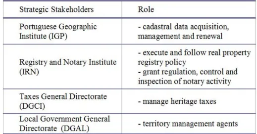
Due to the project assumptions, mainly to the decision that cadastre must be a part of legal real property market, there were defined four SiNErGIC strategic stakeholders.
Figure 1: SiNErGIC stakeholders and their role on legal real property market 3.1 Ongoing Development
Until now a several number of actions were undertaken that determine the short term strategy of SiNErGIC:
- Legal Framework: Decree-Law n. 224/2007, 31st of May that defines cadastral data acquisition process, agents involved and the mains principles of cadastre exploitation; leaves for further definition cadastre update and maintenance.
- SiNErGIC Information System: requirements specification and functional design and analysis.
- Cadastre content: plan for cadastral data acquisition; cadastral data acquisition operation pilot-project at Albergaria-dos-Doze parish; Cadastral data acquisition specification; public international tender for cadastral data acquisition in 7 municipalities.
3.2 Cost-Benefit Analysis
The main component of SiNErGIC is the cadastral data and its added-value for several economic and social activities. Cadastral data acquisition is a very expensive project that will take multiple years to achieve nationwide and will have a significant impact at local level, economic and socially. Most important is how this data will be managed and updated.
Therefore, a very extensive Cost-Benefit Analysis (CBA) was undertaken in 2007 to precisely estimate the project’s costs, to support financial candidatures and to critical and external evaluate it. The timeline for the CBA analysis was a 30 year period, including a 15 year period for data acquisition.
After a pilot-project of data acquisition there were defined tasks and activities of these operations and its costs, which were crossed with the main constraints that will affect them such as area, orography, land use, revenue owners, rainfall, parcels fractionation, population,
number of parishes (lowest administrative level) and the existence of GRPC. It was also estimated SiNErGIC information system costs during the project lifetime.
CBA could not be restrained to financial analysis because not all the costs and benefits can be translated into cash flows. For instance, in the benefits there are several expectable consequences that can turn into cost decrease, efficiencies or externel gains.
CBA results showed that, as expected, costs have a bigger impact in the first years of data acquisition. In terms of benefits they have two different stages: financial benefits occur mainly on the investment years which are related with the expectations of more real property registry revenues – parcels that are not registered before cadastre exists; economical benefits has an increase function associated with emphasis to the years after the data acquisition. The CBA report concluded that, although the financial cost-benefit analysis has a negative value, the economic cost-benefits income surpasses it by far, indicating that for every Euro invested there will be an overcome of 3.6 Euros. It also indicates that the project is viable and largely justifiable, and should be organized in a mounting wave strategy during investment and exploitation phases under a safe strategic financial framework.
4. SiNErGIC Information System
In order to achieve benefits from the existence of cadastre not only data is needed, but also a sustainable and efficient information system to manage the cadastral data.
The bases upon the SiNErGIC-IS is created are that each stakeholder manages and updates their own databases in respect to which parcel characterization they are responsible for: - IGP: spatial data;
- IRN: parcel and owner registry;
- DGCI – tax data;
- Municipalities – land management.
They will communicate between them by an application platform, which can be designated as the SiNErGIC-IS core. This platform makes parcel identification and characterization data and information available to the society by web-browser.
4.1 Update Processes
A key aspect of SiNErGIC is its role in updating parcels spatial changes parcels, such as division or union. The principal assumptions for all parcel spatial changes processes is that any owner who pretends, for instance, divide its parcel, may do it by internet or into a one-stop spot. It is Public Administration responsibility to execute and finish the process through interoperability between SiNErGIC stakeholders.
Likewise, these stakeholders can access the same information avoiding multiple physical travels to citizens and multiple changes of paper documents with information that Public Administration already has. Thus is possible to increase efficiency, transparency and also reduce timelines and costs for the owners.
SiNErGIC-IS brings a set of potential benefits, such as:
- automatic trigger of processes related to parcel spatial changes, such as building permission or authorization to register the new parcels in real property registry;
- participation of a licensed cadastral expert surveyor in the beginning of the process, reducing time analysis of each stakeholder;
- increase transparency in legal real property market, allowing everyone to access at the same information at the same time;
- reduce multiple forms fill to a single digital form at the beginning of the process; - no documents duplication to multiple public services;
- no physical documents transmission between Public Administration.
4.2 Conception and Implementation
SiNErGIC-IS conception and implementation is being UE financed and corresponds only to the bases of the information system architecture before the cadastral data acquisition begins. SiNErGIC-IS conception was made based upon the follow stages:
- SiNErGIC-IS requirement specification;
- System architecture functional design and analysis;
- System management application functional design and analysis;
- Cadastral data application schema functional design and analysis;
- Functional design and analysis of the interaction in the interoperability layer between stakeholders information systems;
- Technological infrastructure architecture design to support the system and its scalability; - Authentication platform functional design and analysis.
4.2.1 Business processes definition
The first step was to map the strategic goals and data flow on the business level to be granted by the SiNErGIC-IS. The data flows allowed the understanding of interactions between IGP and other stakeholders, as well as define the procedures boundaries for cadastral data acquisition and management.
At this point, IGP was able to define the follow processes at a macro level: - cadastral data acquisition;
- cadastral management and update;
- cadastral exploitation;
- supporting processes.
In order to assure alignment between SiNErGIC functionalities and the cadastre management and exploitation business, the supporting business processes were systematized.
4.2.2 Application modules
With the cadastral data application schema established, IGP was then able to identify the application modules by crossing business processes with the information entities. In a global perspective there will be seven application modules:
- Operations Management System: responsible for supporting the beginning and ending of
- Cadastre Management System: responsible for supporting cadastral data acquisition and update, as well as for the cadastral objects life cycle.
- Query Management System: responsible for supporting query requests during acquisition
and update operations as well as for payments and transactions history management.
- Document Management System: responsible for supporting documents issue, upload and
signature.
- Alert Management System: responsible for supporting alert issue, send and reply to designated users.
- Access Management System: responsible for user accounts, functions and credentials. - Entities Management System: responsible for external entities catalogue maintenance. 4.2.3 Application architecture
The application architecture will be organized into four layers:
- Human Interface or Presentation Level: ensure access by Web interface in Front-Office
(internet) and by Web, Thin and Thick Client interfaces in Back-Office (Safe Network). - Network Interface or Integration Level: intended to integrate application modules with
other internal or external systems.
- Applicational or Business Level: ensure that defined business rules are properly executed, according to specified access or functional profiles.
- Data or Persistence Level: it will be a single central repository for all the internal systems of SiNErGIC-IS that must integrate all necessary informational entities to business process management; information can be only be manipulated by the Applicational or Business Level, and any other system besides the one that is the repository administrator can access data in a no-safe mode.
Consequently application modules will be implemented in the defined layer according to the functional requirements of each one.
4.2.4 Services Catalogue
Another important definition was the services catalogue that will be available for each application module, focussing in the network interface layer services that support interoperability between Stakeholder information systems. Services Catalogue was organized according to their architecture layer, as follows:
- Human Interface Service;
- Network Interface Service;
- Business Logic Service.
SiNErGIC-IS is expected to be completely implemented by the end of 2010, in time to be tested on the on-going cadastral data acquisition operations and to manage and update its output.
5. Cadastral Data Acquisition 5.1 Data
Cadastral content means characterizing elements of parcel structure, ie real property cadastre. SiNErGIC was created so that real property cadastre in Portugal corresponded to a multifunctional, interoperable, exhaustive, methodical, updated and juridical inventory that pretends to achieve unique parcel identification nationwide.
5.1.1 Multifunctional
Creation of a single registry, for all parcels, that will work as a transversal tool for land management and serves all citizens. Parcel structure must be identifiable and characterized in a way that allows it to play different roles, depending on the scope of action of interested agents.
5.1.2 Interoperable
Real property cadastre must be consider as support information, among others to real property transaction, a fair land taxation and land management. Tool that single identifies parcels and other systems may work upon.
5.1.3 Exhaustive, methodical, updated and simple
Real property cadastre must be done nationwide to ensure equity among citizens; cadastral data acquisition and management must be under methodical and systematic rules. On the other hand, cadastre has to be permanently available by which means as to be always updated. 5.1.4 Juridical
It is clear that land management paradigm is the single identification of autonomous juridical property. It is a global purpose, because physical, fiscal and economical parcel identification as well as its owners matters to all territory agents.
5.2 Cadastral Data Acquisition Operations
Cadastral data acquisition is made through a five step operation:
- Publicity: crucial to raise owners awareness for what is at stake if there is not a global commitment with it.
- Mapping support acquisition: toponymy digital orthophotos with 10 cm spatial resolution on the ground for supporting recognition and completion of field cadastral survey;
- Cadastral data acquisition: field works, including survey, that enables parcel structure identification and characterization, articulated with owners identification forms;
- Public Consultation: public exposure of collected cadastral data for confirmation and complaint;
- Operation Control and Technical Support: control and monitor all aspects related with the operation.
In these operations, only the parcels that are declared by its owner and are clearly marked or limited in the field are surveyed. Remaining areas are considered blank areas and once operations are finalized, they are not allowed to be transacted until they become parcel with an identification number.
The private sector will be responsible for cadastral data acquisition operations, through international tenders.
The first operation is scheduled to start in this first semester of 2010 and includes seven municipalities’ areas. These areas are spread nationwide and were chosen due to its cost and the fact that they have a high percentage of economically important forestry areas.
Data specifications were produced in accordance to ISO norms and Inspire Data Specifications.
The timeline and complexity of cadastral content acquisition depends directly on the parcel concept. The physical elements defined as parcel characterizing determine how the acquisition process is done and, consequently, its complexity – as more detailed parcel characterizing elements are more complex and demanding these operations will be.
Data acquisition will focus on the truly identifiers and characterizing elements of parcel structure, since only cadastral entities will be acquired, not overloading the operation with acquisition of mapping entities – wells, tanks, ride walkways, etc. Once again, the goal is to avoid data and information duplication and at the same time ensure the parcel structure update viability.
The data acquisition will be limited, in general terms, to the follow: - spatial data: parcel marks and boundaries;
- descriptive data: personal data of the property right holder, parcel nature, real property registry identification, property tax identification, parcel number identification.
It should be notice that it is the property right holder that is wanted, not the property revenue holder; as well as it is the juridical parcel, not the sub-parcel of land use.
5.2.1 Publicity
This stage is begun two months before cadastral data acquisition is started. It includes TV, radio and newspaper ads nationwide, town meetings to explain the operation, announcement spread in multiples places in the operation area and contiguous. There is a special emphasis to explain how can owners mark their parcels and that this operation purposes is not to collect more taxes.
5.2.2 Mapping support acquisition
Due to technology developments, owner parcel identification needs and add-value that it can bring to other economy interests, IGP decided to establish the necessity of 10 cm spatial resolution orthophotos.
Cadastral data is acquired mainly by field survey. That does not mean that, if a boundary or mark is clearly identifiable on orthophotos, it cannot be acquired directly from it.
The orthophotos are also important because it allows owners to identify their parcels during the acquisition and public consultation phase.
When operation is concluded, they are used as geographic layer in the SiNErGIC-IS helping user to locate.
Toponymy and addresses are also very important to locate parcels. Since there is a significant gap in this information layer in rural areas this data collection, although optional, can be very helpful for who has to perform parcel survey.
5.2.3 Cadastral Data Acquisition
The most important operation stage is divided in three main areas:
- Owners declaration;
- Parcel survey;
- Data integration.
This stage has a pre-defined timeline, no less than 6 months, in order to allow owners that live away from their parcels, to have enough time to participate in the operation.
In each parish there is an office where the owner can go to, in order to declare their parcels or any other issue. It is not mandatory to declare it at the office. The owner’s declaration is an e-form that can be accessed through SiNErGIC-IS web site.
Parallel, there are multiple survey teams on the field to identify and survey the marked or limited parcels. For this purpose, IGP has established a Portuguese GNSS CORS Network – Continuously Operating Reference Station Network. Data acquisition will be performed on the field using multiple survey methods and instruments, with special emphasis to the use of GPS-RTK receivers and Tablet PC.
Permanently there are also information systems professionals working in data quality control and integrate data from the owner declaration with the survey parcels.
5.2.4 Public Consultation
When the prior phase its concluded, data is sent to IGP to a final validation and, if accepted, is sent back to the company responsible for the data acquisition in order to be open to a Public Consultation.
During a period of two to four weeks, data is available for all, both in a local office or SiNErGIC-IS web site.
At this stage anyone can complaint about a parcel identification or characterization. The complaint has a pre-analysis done by who perform the parcel survey and then is sent to a Local Technical Support Commission (LTSC) with representatives from:
- IGP: coordinator and responsible for spatial data analysis; - IRN: responsible for parcel registry and ownership analysis; - DGCI: responsible for tax data analysis;
- Municipality: responsible for complementary data analysis (e.g. addresses). The owner can also confirm the parcels identification or/and characterization.
If a complaint is accepted by LTSC the area is either surveyed again or is changed to a blank area until there is a judicial or friendly conflict resolution.
5.2.5 Operation Control and Technical Support
This is a continuously work from day one of publicity until the final acceptance of cadastral data acquired. IGP has survey team on the field to verify work procedures and positional accuracy, and there is also the LTSC who gives support to both owners and the company responsible for the operation.
6. Future Actions
If we would consider this project in an athletics perspective, it would have to be considered a marathon. However, the results expectation is raising high and the demand for cadastre is increasing in multiple places and economical sectors. But, like in athletics, a marathon racer cannot be placed in a one hundred meter race and be expected to win. It is just not possible. SiNErGIC project and similar ones can only be viable when agreement platforms between real property stakeholders are reached and remain sustainable in the long term. It is our believe, undoubtedly, that although SiNErGIC successful path will be long and, for times, painful, in the end it will bring a enormous add-value to Portugal land management policy. The undergoing definition of cadastre business model and its financial plan are essential to define this project speed. This is crucial to stakeholders in order for them to establish their resources needs and infra-structure re-alignments.
In the short term, cadastre acquisition operations will begin in seven municipalities and similar operations are already being planned due to the demand of this information, e.g. Lisbon and forestry high-density areas. Its expected that by the end of 2010 cadastre management and update legal framework as well as SiNErGIC-IS will be completed and implemented, respectively.
BIOGRAPHICAL NOTES
Rui Pedro Julião, PhD in Geography and Regional Planning – New Technologies in Geography, is actually Deputy Director-General of Portuguese Geographic Institute (in charge of research, cadastre, IT and National Spatial Data Infrastructure), Assistant Professor of New University of Lisbon and researcher at e-GEO – Centre for research in Geography and Regional Planning.
Is author of several publications (over 60) including books, book chapters, articles and papers published nationally and internationally and regularly participates at main national and international conferences related with Geographic Information science and systems as well as presenter, session chair, member of programme and organization committees.
Catarina Costa Roque, Licensed in Surveying Engineering, is since March 2003 Cadastral Information Services Director of Portuguese Geographic Institute. Before that Catarina Costa Roque was Geographic Information Management and Exploitation Center Director for one year also of Portuguese Geographic Institute. From 1995 until 2002 Catarina Costa Roque was a Superior Technician of Army Geographic Institute.
José Pedro Neto, Licensed in Surveying Engineering, is since October 2007 head of Cadastral Information Acquisition Division of Portuguese Geographic Institute. Before that José Pedro Neto was a Superior Technician of Portuguese Geographic Institute for 7 years. From 1999 until 2000 José Pedro Neto was a Technical Consultant at a private sector company.
CONTACTS
Prof. Dr. Rui Pedro Julião Deputy Director-General Instituto Geográfico Português Rua de Artilharia Um, 107 1099-052 Lisboa
PORTUGAL
Tel. + 351 21 381 96 91 Fax + 351 21 381 96 99 Email: rpj@igeo.pt
Web site: www.igeo.pt
Engª Catarina Costa Roque
Cadastral Information Services Director Instituto Geográfico Português
Rua de Artilharia Um, 107 1099-052 Lisboa
PORTUGAL
Tel. + 351 21 381 96 00 Fax + 351 21 381 96 99 Email: croque@igeo.pt
Web site: www.igeo.pt
Engº José Pedro Neto
Chief of Cadastral Information Acquisition Division Instituto Geográfico Português
Rua de Artilharia Um, 107 1099-052 Lisboa
PORTUGAL
Tel. + 351 21 381 96 00 Fax + 351 21 381 96 99 Email: jneto@igeo.pt