Procedia Computer Science 31 ( 2014 ) 542 – 551
1877-0509 © 2014 Published by Elsevier B.V. Open access under CC BY-NC-ND license. Selection and peer-review under responsibility of the Organizing Committee of ITQM 2014. doi: 10.1016/j.procs.2014.05.300
ScienceDirect
2nd International Conference on Information Technology and Quantitative Management,
ITQM 2014
Correlation Analysis for Multiple-Dimensional Properties of Water
Recourses
Qin Zhang
a, Manjin Cheng
b, Yuhong Xia
c, Fuqiang Guo
b, Yingjie Tian
aaResearch Center on Fictitious Economy and Data Science, Chinese Academy of Sciences, Beijing 100190, China bInner Mongolia Autonomous Region Research Institute on Hydraulic Sciences, Hohhot, Inner Mongolia 010020, China
cInner Mongolia Bayannoer Water Conservancy Bureau, Bayannur, Inner Mongolia 015000,China
Abstract
Large-scale irrigation districts are the important scale agricultural and commodity grain production bases in the world. The total amount control and multi-dimensional critical regulation and control technology of water resources in irrigation districts have become the key problems of food security and water safety in China. In this paper, we mainly research on water recourse of the Hetao irrigation area in Inner Mongolia, establish the multi-dimensional attributes index system of water recourses in Inner Mongolia Hetao irrigation district, analyze the internal relationship of attributes in the same dimension and between the multi-dimensions, adjust and improve the original index system, and further put forward the specific adjusting and controlling index of water recourses for each dimension. The purpose of all these works is to provide technology support to establish the multi-dimensional critical control model of water resources in the Hetao irrigation district, ultimately achieving the goal of social and economic sustainable development in the irrigation area.
c
2014 The Authors. Published by Elsevier B.V.
Selection and peer-review under responsibility of the Organizing Committee of ITQM 2014.
Keywords: Correlation analysis; Water recourses; Multi-dimensional regulation; Index system
1. Background
Large-scale irrigation districts are the important scale agricultural and commodity grain production bases in the world. The total amount control and multi-scale allocation technology of agriculture water resources in irrigation
districts have become the safeguard of our country’s key problems of food security and water safety15. China has
existing 402 large irrigation areas which are bigger than 20,000 hectares, effective irrigation areas are more than
1.58 million hectares, about 30% of the total irrigation areas in our country, produce more than a quarter of the total
grain production, create more than a third of the country’s gross national farm product, provide more than 1/7 of the
∗Yingjie Tian
E-mail address:[email protected]
© 2014 Published by Elsevier B.V. Open access under CC BY-NC-ND license.
country’s industrial and urban domestic water, benefit more than 200 million people6. Large-scale irrigation districts
have a direct influence with the local people’s live and the safety of living environment, production development, life safeguard, and all people’s livelihood of water conservancy projects. The shortage of irrigation water is the most important factor restricting the development of agriculture in north China. Under the shortage of water resources, how to guarantee the development of irrigated agriculture is a problem we must face. Controlling the total amount
of irrigation water and reasonably allocating limited irrigation water are effective ways to solve above problem.
Ac-cording to these situations, the irrigation districts’ agriculture water resources controlling and multi-scale allocation technology have become the key support to the protection of the food security and the solution of water problems in
our country16.
The Hetao irrigation district in Inner Mongolia is one of the three very large irrigation area in China, the average rainfall in the district is less than 250 millimeters, and the average evaporation is more than 2000 millimeters for many years, the agricultural production water is all depend on the Yellow River. No irrigation, no agriculture. From
1980 to 2000, the annual amount of water used in irrigation districts from the Yellow River is 5.2 billionm3 14. To
solve the problem of the contradiction between demand and supply of water resources in the Yellow River basin, the Yellow River Conservancy Commission stipulated that the quantity of water diversion from Yellow River for Hetao
irrigation area cut down to 4 billionm3 from 5 billionm3in 2000 to 2010, the reduction reaches 20%. That must
have a significant influence to the development of agricultural irrigation. From 1999 to 2009, the implementation of
water-saving engineering in irrigation districts gradually reduced to 4.5 billionm3, but to the requirement of 4 billion
m3, the Hetao irrigation must reduce more 500 millionm3water every year, the lack of water will be further sharp.
On the other hand, in recent years,the industrial and urban development of Bayannur need more and more water, forcing the agriculture in Hetao irrigation district release some water to meet the demand of industrial and urban
development in irrigation area. In 2008, Bayannur owned 5.53 billionm3water resources in total, the surface water
resources are 4.62 billionm3, and the groundwater resources are 2.46 billionm3. In 2008, in Bayannur’s administrative
partition of total water use, agricultural water consumption is 4.71 billionm3, accounting for 96.4% of the total water,
industrial water consumption is 96 millionm3, accounting for 2.0% of the total water, life water consumption is 79
millionm3, accounting for 1.6% of the total water. On the other hand, from the periods of agriculture water using in
the Hetao irrigation district, the agriculture water resources are more lack, especially from the mid September to the
end of October, due to the large area of the irrigation distinct, the autumn irrigation water account to 1/2 of the total
irrigation water quoted from the Yellow River every year, the contradiction between demand and supply is very sharp in this period. At the same time, with the influences of land household contract management, planting structure make crop water requirement be not synchronized, causes the large amount of waste water, intensified shortage of irrigation district agriculture water recourses.
At the same time, the irrigation return water carry a large amount of nitrogen and phosphorus into surface water and groundwater making the amount of nitrogen and phosphorus in surface water and groundwater in irrigation area gen-erally overweight, making the safety of local people’s drinking water be in great danger. The reducing of agricultural irrigation water in the Hetao irrigation area, the deterioration of ecological environment, the urban domestic water in irrigation area and the social and economic development on water resources competition, have seriously restricted the development of agricultural production in the Hetao irrigation area.
In this paper, we mainly research on water recourse of the Hetao irrigation area in Inner Mongolia, establish the multi-dimensional attributes index system of water recourses in Inner Mongolia Hetao irrigation district, analyze the internal relationship of attributes in the same dimension and between the multi-dimensions, adjust and improve the original index system, and further put forward the specific adjusting and controlling index of water recourses for each dimension. The purpose of all these works is to provide technology support to establish the multi-dimensional critical control model of agriculture water resources in the Hetao irrigation district, ultimately achieving the goal of social and economic sustainable development in the irrigation area.
The rest of the paper is organized as follows: Section 2 briefly introduces the principle and calculation of correla-tion analysis. Seccorrela-tion 3 proposes the correlacorrela-tion analysis of multiple-dimensional properties about water recourses,
including the analysis of properties in the same dimension and between the different dimensions. Section 4 contains
2. Principle of Correlation Analysis
Correlation analysis refers to two or more variables which are relevant, and the purpose is to measure the degree of how closely related the two variable factors are. Correlation does not equal to causation, also not a simple instantiate dependency. The fields correlation analysis covered almost include all aspects we usually face.
In mathematical statistics, the covariance and correlation function are extremely important digital features of s-tochastic variables. For variablex=(x1,x2, . . . ,xn)∈Rn, define
Ci j=E((xi−E(xi))(xj−E(xj))),i,j=1,2, . . . ,n, (1)
whereE(x) is the mathematical expectation of variablex.
Matrix C= ⎛ ⎜⎜⎜⎜⎜ ⎜⎜⎜⎜⎜ ⎝ c11· · ·c1n ... ... ... cn1· · ·cnn ⎞ ⎟⎟⎟⎟⎟ ⎟⎟⎟⎟⎟ ⎠ (2)
is the covariance matrix of the random variablex=(x1,· · ·,xn). The correlation coefficient is defined as
Ri j= √Ci j Cii·Cj j, (3) and matrix R= ⎛ ⎜⎜⎜⎜⎜ ⎜⎜⎜⎜⎜ ⎝ R11· · ·R1n ... ... ... Rn1· · ·Rnn ⎞ ⎟⎟⎟⎟⎟ ⎟⎟⎟⎟⎟ ⎠ (4)
is the correlation coefficient matrix of variablex.
For the correlation coefficientRi j∈[−1,1], there are following properties:
• IfRi j>0, it demonstrates that variablesxi,xjare positive correlated;
• IfRi j<0, it demonstrates that variablesxi,xjare negative correlated;
• If|Ri j|=1, it demonstrates that variablesxi,xjhave completely linear correlation, in the other word,xi,xjhave
functional relationship;
• IfRi j=0, it demonstrates that variablesxi,xjalmost have no linear correlation;
When 0<|Ri j|<1, it means variablesxi,xjhave varying degrees of linear correlation, and if the value of|Ri j|is
more close to 1, the correlation of the two variables is more close; oppositely, if the value of|Ri j|is more close to 0, it
means the correlation of the two variables is more weak. Following the experience, we can have the following rules:
|Ri j|<0.4 means low linear correlation; 0.4<|Ri j|<0.75 means significant linear correlation; 0.75<|Ri j|<1 means
highly linear correlation.
3. Correlation analysis of multiple-dimensional properties about water recourses
The natural water cycles are the product of natural systems, are the result of the long-term interaction between climate and biosphere, provide foundation for keeping ecological balance, developing economic and social system, and protecting environment. Without human beings, the water cycles just have natural qualities, with the development of society, the service function of water make water become valuable resources, at the same time, water recourses
appeared obvious social attributes, economic attributes and ecological attributes18,9. So we explore water recourses’
natural, social, economic, recourse and ecological properties to study water resources’ natural characteristics and influences on human beings’ living and production.
Under the influences of environmental change and strong human activities, water cycle shows obviously the
natural-artificial characters and multiple-dimensional properties on all aspects of dynamics, structure and parameters15.
Social dimension describe how water recourses as a critical recourse factor like land and energy influence the devel-opment of society through water recourses’ supply, use, consumption and emission; economic dimension describe
water recourses’ commodity value and market effects when they be used as economic productive factors;
ecologi-cal dimension describe water recourses’ aquatic ecologiecologi-cal service functions in natural conditions and influences on
environmental system6,16. Due to the impact of strong human activities, for water cycle in Inner Mongolia Hetao
irrigation area, its economic dimension properties become stronger, recourse dimension and ecological dimension properties become weaker, social dimensional properties become variant, the coordination of water recourses’ multi-dimensional properties has been certain destructed. So we establish the multi-multi-dimensional attributes index system of water recourses in Inner Mongolia Hetao irrigation district, analyze the internal relationship of attributes in the same dimension and between the multi-dimensions, adjust and improve the original index system, and further put forward the specific adjusting and controlling index of water recourses for each dimension.
3.1. Correlation analysis of properties in the same dimension 3.1.1. Resource dimension
The description of water resources of Inner Mongolia Hetao irrigation area in resource dimension is mainly di-vided into six parts: water resources endowment, Resource matching degree, the quantity of water resources, the utilizable quantity of water resources, supply amount of water resources, the amount of water resources to the
con-sumption14,17,5,10,7,1. Combining with the actual situation of Inner Mongolia Hetao irrigation district, the specific
properties description of these six parts of water resources is shown in table 1.
Table 1. The properties of water resources in resource dimension.
dimension category properties Precipitation
Natural characteristics of water resources Ratio of evaporation and rainfall Mean annual runoffamount
Resource matching degree Average per capita water resources availability Water resources quantity Irrigation quota
Total amount of water resources Resource dimension Surface water resources amount Utilizable quantity of water resources Groundwater resources amount
Water supply
Surface water resources amount Available water supply Groundwater use
Other surface water use
The difference between the total water use and ecological water use Water consumption Inter-basin Water Transfers
Annual average evaporation National economic water consumption
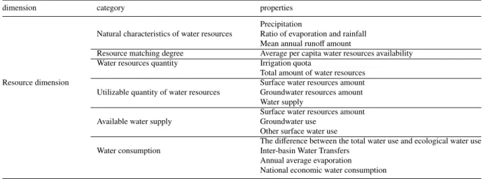
Based on the detailed data, we explore the correlation between this 15 attributes of water resources in resource
dimension. According to the number of the corresponding correlation coefficients, we can get the relationship figure
of the high-related attributes, as shown in Fig. 1. In the figure, if two attributes are connected, they are highly linear related.
From Fig. 1., we can see precipitation, water supply, the difference between total water use and ecological water
use, inter-basin water transfers, the national economic water consumption, the ratio of evaporation and rainfall,
irriga-tion quota and mean annual runoffamount are all strongly correlated, and from the actual meaning of these properties,
there are also strong correlation between them, so we can combine them to a comprehensive index measuring the resource dimension of water resource in Hetao irrigation district, called ”comprehensive index of water resources’ supply, use and consumption”. The numerical value of the comprehensive index is the mean value of all the related properties, the positive or negative correlation between them has been taken into account. From Fig. 1., we can also see that groundwater resources amount and total water resources amount are highly related, so we combine them to ”comprehensive index of water quantity”. From the figure, we can see other surface water use and the average per
,UULJDWLRQ TXRWD
:DWHU VXSSO\ ,QWHUEDVLQ :DWHU7UDQVIHUV
7KH QDWLRQDO HFRQRPLF ZDWHU FRQVXPSWLRQ
7KH GLIIHUHQFH EHWZHHQ WKH WRWDO ZDWHU XVH DQG HFRORJLFDO ZDWHU XVH 3UHFLSLWDWLRQ 7KH UDWLR RI HYDSRUDWLRQ DQG UDLQIDOO 0HDQ DQQXDO UXQRII DPRXQW 6XUIDFH ZDWHU UHVRXUFHV DPRXQW 7RWDO DPRXQW RI ZDWHU UHVRXUFHV *URXQGZDWHU UHVRXUFHV DPRXQW
Fig. 1. The highly related properties in resource dimension.
capita water resources availability are highly related, but the actual meaning they represent are much different, so we
save this two instead of combining them. 3.1.2. Economic dimension
The description of water resources in economic dimension in Inner Mongolia Hetao irrigation area includes four parts: economic development level, water usage level, water diversion from the Yellow River and economic value of
water11?,3. Combining with the actual situation of Inner Mongolia Hetao irrigation district, the specific properties
description is shown in table 2.
Table 2. The properties of water resources in economic dimension.
dimension category properties
Population GDP
The first industry GDP Economic development level Gross industrial production
Construction industry GDP Total grain output Tertiary industry GDP Domestic water consumption Agricultural irrigation water use Economic dimension Water usage level General industrial water use
Surface water supply Groundwater water supply Sewage waste water emissions
Water net diversion from the Yellow River Water diversion from the Yellow River Total trench Water loss
Total small trench water diverted Net water consumption per unit of GDP Economic value of water Total water consumption
Water economic value in planting industry The ratio of GDP and total water consumption
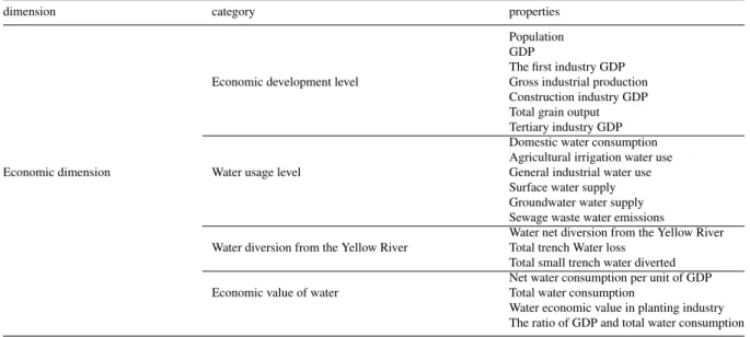
Based on the detailed data, we explore the correlation between the 20 attributes of water resources in economic
dimension. Similar to resource dimension, according to the numerical value of correlation coefficients, we can get the
relationship figure of the high-related attributes in economic dimension, showed in Fig. 2.
From Fig. 2., we can see GDP, the first industry GDP, gross industrial production, construction industry GDP, the total grain output, the tertiary industry GDP, general industrial water use, net water consumption per unit of GDP, water
*'3 dŽƚĂůƚƌĞŶĐŚ :DWHU ORVV 6HZDJH ZDVWH ZDWHU HPLVVLRQV 7KH UDWLR RI *'3 DQG WRWDO ZDWHU FRQVXPSWLRQ :DWHU HFRQRPLF YDOXH LQ SODQWLQJ LQGXVWU\ 1HW ZDWHU FRQVXPSWLRQ SHU XQLW RI *'3 *HQHUDO LQGXVWULDO ZDWHU XVH 7KH WHUWLDU\ LQGXVWU\ *'3 7KH WRWDO JUDLQ RXWSXW &RQVWUXFWLRQ LQGXVWU\ *'3 *URVV LQGXVWULDO SURGXFWLRQ 7KH ILUVW LQGXVWU\ *'3 'RPHVWLF ZDWHU FRQVXPSWLRQ 7KH VXUIDFH ZDWHU VXSSO\ $JULFXOWXUDO LUULJDWLRQ ZDWHU XVH
7RWDO VPDOO WUHQFK ZDWHU GLYHUWHG 7RWDO ZDWHU FRQVXPSWLRQ :DWHU QHW GLYHUVLRQ IURP WKH <HOORZ 5LYHU
Fig. 2. The highly related properties in economic dimension.
economic value in planting industry, the ratio of GDP and total water consumption, sewage waste water emissions and total trench water loss are all strongly correlated, and from the actual meaning they represent, they are also highly correlated. We combine these 12 attributes to a comprehensive index measuring the economic dimension of water resources, called ”comprehensive index of water resources’ economic value”. Based on the same consideration, we combine agricultural irrigation water use, the surface water supply, water net diversion from the Yellow River and total water consumption to ”comprehensive index of water diversion and use”. From Fig. 2., we can also see domestic water consumption and total small trench water diverted also highly related, but consider the actual meaning of them, we do not combine them.
3.1.3. Social dimension
The description of water resources in social dimension in Inner Mongolia Hetao irrigation area includes four parts:
integrated water quantity, per capita water supply guarantee, water shortage degree, the water quality grade?12.
Com-bining with the actual situation of Inner Mongolia Hetao irrigation district, the specific properties in social dimension are showed in table 3.
Table 3. The properties of water resources in social dimension.
dimension category properties
Integrated water quantity Average domestic water-consumption per person Irrigation quota
Per capita water supply guarantee Urban per capita water consumption quota Rural per capita water consumption quota The first industry water consumption per year Social dimension Water shortage degree The second industry water consumption per year
The third industry water consumption per year
Irrigation period average salinity of the Yellow River irrigation area The average salinity of the total drainage ditch discharged into Ulansuhai Nur The average salinity of Ulansuhai Nur discharged into the yellow river Water quality grade The average salinity of groundwater in Hetao irrigation area
Ulansuhai Nur water quality
The average sediment concentration of water from the Yellow River Wastewater emissions
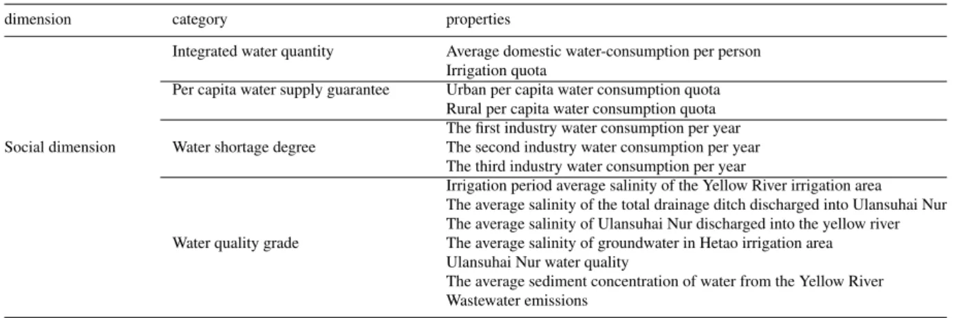
Based on the detailed data, we explore the correlation between the 14 attributes of water resources in social
dimen-sion. Similarly, according to the numerical value of correlation coefficients, we can get the relationship figure of the
high-related attributes in social dimension, showed in Fig. 3.
7KH DYHUDJH VHGLPHQW FRQFHQWUDWLRQ RI ZDWHU IURP WKH <HOORZ 5LYHU
7KH DYHUDJH VDOLQLW\ RI JURXQGZDWHU LQ +HWDR
LUULJDWLRQ DUHD 7KH DYHUDJH VDOLQLW\ RI WKH
WRWDO GUDLQDJH GLWFK GLVFKDUJHG LQWR 8ODQVXKDL 1XU
$YHUDJH GRPHVWLF ZDWHU FRQVXPSWLRQ SHU SHUVRQ ,UULJDWLRQ TXRWD
7KH ILUVW LQGXVWU\ ZDWHU FRQVXPSWLRQ SHU \HDU
7KH VHFRQG LQGXVWU\ ZDWHU FRQVXPSWLRQ SHU \HDU :DVWHZDWHU HPLVVLRQV
8UEDQ SHU FDSLWD ZDWHU FRQVXPSWLRQ TXRWD
Fig. 3. The highly related properties in social dimension.
In social dimension, we combine urban per capita water consumption quota, wastewater emissions, the second in-dustry water consumption per year to ”the second inin-dustry drainage comprehensive index”, combine the first inin-dustry water consumption per year, irrigation quota and average domestic water-consumption per person to ”the first industry drainage comprehensive index”, combine the average salinity of the total drainage ditch discharged into Ulansuhai Nur and The average salinity of groundwater in Hetao irrigation area to ”the salinity of water in Hetao irrigation area comprehensive index”.
3.1.4. Ecological dimension
The description of water resources in ecological dimension in Inner Mongolia Hetao irrigation area includes four parts: ecotype, ecological functions, ensurance of the balance of Ulansuhai Nur water, COD emissions and quality
grade3,2,19,4,8. Combining with the actual situation of Inner Mongolia Hetao irrigation district, the specific properties
in ecological dimension are showed in table 4.
Table 4. The properties of water resources in ecological dimension.
dimension category properties
Cultivated Land Area Forestry land area Pasture area Ecotype Forest coverage rate
Cattle Number Horse number Sheep Number pig number
Ecological dimension gross amount of water resources Total water supply
Total water consumption
Ecological functions Amount of water in medium-sized reservoirs Irrigation area groundwater average buried depth Water used for ecological environment Amount of water into the sea Ensure the balance of Ulansuhai Nur water Amount of water into Wuhai
Amount of water out from Wuhai COD emissions and quality grade COD Emissions
Similar to the above three dimensions, based on the detailed data, we explored the correlation between the 19
attributes of water resources in ecological dimension. According to the numerical value of correlation coefficients, we
can get the relationship figure of the high-related attributes in ecological dimension, showed in Fig. 4.
)RUHVW FRYHUDJH UDWH
7KH DPRXQW RI ZDWHU LQ PHGLXP
VL]HG UHVHUYRLUV
&DWWOH QXPEHU HFRORJLFDO HQYLURQPHQW:DWHU XVHG IRU 6KHHS QXPEHU )RUHVWU\ ODQG DUHD +RUVH QXPEHU *URVV DPRXQW RI ZDWHU UHVRXUFHV 7KH DPRXQW RI ZDWHU LQWR :XKDL &XOWLYDWHG /DQG $UHD 3LJ QXPEHU
&2' HPLVVLRQV 7KH DPRXQW RI ZDWHURXW IURP :XKDL
7RWDO ZDWHU FRQVXPSWLRQ 7RWDO ZDWHU VXSSO\ 3DVWXUH DUHD 7KH UDWH RI SROOXWDQW HPLVVLRQ LQWR ULYHU UHGXFWLRQV
Fig. 4. The highly related properties in ecological dimension.
In ecological dimension, we combine cattle number, horse number, sheep number and pig number to ”Biodiversity index”, combine cultivated land area, forestry land area, forest coverage rate to ”vegetation cover index”, combine gross amount of water resources, the amount of water in medium-sized reservoirs, water used for ecological environ-ment, the amount of water into Wuhai and the amount of water out from Wuhai to ”comprehensive index of water balance”, combine total water supply and total water consumption to ”comprehensive index of total water supply and use”.
3.2. Correlation analysis of properties between all dimensions
After above discussion of the properties in the same dimension, the final properties are shown in table 5. Not only the properties in the same dimensions are related, all the properties in resource, economic, social and ecological dimensions are linked in myriad ways. So we explored the correlations between all the 29 properties. Similarly,
according to the numerical value of correlation coefficients, we get the relationship figure of the high-related attributes
in all dimensions, showed in Fig. 5., where resource dimension marked in red, economic dimension marked in yellow, social dimension marked in blue and ecologic dimension marked in green. From the figure, we can see all the four dimensions are related. The correlation between resource dimension, economical dimension and social dimension are very strong, especially the economical dimension, all the 6 properties in this dimension are highly related to the other three dimensions. Resource dimension and social dimension are also highly related, whereas the correlation between ecologic dimension and social dimension is weak.
After analysis of the index system, we obtain the final attributes to describe the multiple-dimensional properties of water resources in Hetao irrigation district. In order to make adjusting and controlling the use, supply and consump-tion of water resource be tangible, we put forward the specific adjusting and controlling index for each dimension: comprehensive index of water resources’ supply, use and consumption in resource dimension, comprehensive index of water resources’ economic value in economic dimension, the first industry drainage comprehensive index in social dimension, the second industry drainage comprehensive index in social dimension, the third industry water consump-tion per year in social dimension, comprehensive index of water balance in ecological dimension and the rate of pollutant emission into river reductions in ecological dimension. In our next step, we will give full consideration to
Table 5. All properties.
dimensions properties
Comprehensive index of water resources’ supply, use and consumption Comprehensive index of water quantity
Surface water resources amount Resource dimension Groundwater use
Other surface water use
The average per capita water resources availability Annual average evaporation
Comprehensive index of water resources’ economic value Comprehensive index of water diversion and use Economic dimension Population
Domestic water consumption Groundwater water supply Total small trench water diverted
The second industry drainage comprehensive index The first industry drainage comprehensive index
The salinity of water in Hetao irrigation area comprehensive index Social dimension The third industry water consumption per year
Irrigation period average salinity of the Yellow River irrigation area The average salinity of Ulansuhai Nur discharged into the yellow river The average sediment concentration of water from the Yellow River Vegetation cover index
Biodiversity index
The comprehensive index of water balance Comprehensive index of Total water supply and use Ecological dimension Pasture area
Irrigation area groundwater average buried depth The amount of water into the sea
COD emissions
The rate of pollutant emission into river reductions
&RPSUHKHQVLYHLQGH[ RI7RWDOZDWHU VXSSO\DQGXVH 7RWDOVPDOOWUHQFK ZDWHUGLYHUWHG ,UULJDWLRQDUHD JURXQGZDWHUDYHUDJH EXULHGGHSWK 6XUIDFHZDWHU UHVRXUFHVDPRXQW &RPSUHKHQVLYHLQGH[RI ZDWHUUHVRXUFHVÿVXSSO\ XVHDQGFRQVXPSWLRQ *URXQGZDWHU ZDWHUVXSSO\ &RPSUHKHQVLYHLQGH[RI ZDWHUGLYHUVLRQDQGXVH &RPSUHKHQVLYHLQGH[RIZDWHU UHVRXUFHVHFRQRPLFYDOXH 7KHVHFRQGLQGXVWU\GUDLQDJH FRPSUHKHQVLYHLQGH[ 2WKHUVXUIDFH ZDWHUXVH 3RSXODWLRQ 7KHWKLUGLQGXVWU\ZDWHU FRQVXPSWLRQSHU\HDU
Fig. 5. The highly related properties in all dimensions.
the inner link between all properties in the four dimensions and the relative influences between different dimensions,
and analyze them with data, only in this way we can get the right decisions which are close to the practical situation and contribute to the development.
4. Conclusion
In this paper, we mainly research on water recourse of the Hetao irrigation area in Inner Mongolia, establish the multi-dimensional attributes index system of water recourses in Inner Mongolia Hetao irrigation district, analyze the internal relationship of attributes in the same dimension and between the multi-dimensions, adjust and improve the original index system, and further put forward the specific adjusting and controlling index of water recourses for each dimension. In our next step, we will give full consideration to the inner link between all properties in the four
dimensions and the relative influences between different dimensions, and analyze them with data, the purpose of all
these works is to provide technology support to establish the multi-dimensional critical control model of agriculture water resources in the Hetao irrigation district, ultimately achieving the goal of social and economic sustainable development in the irrigation area.
Acknowledgements
This work has been partially supported by grants from National Natural Science Foundation of China(No. 11271361), the Ministry of water resources’ special funds for scientific research on public causes(No. 201301094).
References
1. Xifeng Wang, Zuhao Zhou, Yangwen Jia. Advances in water resources evolution research and future prospects.Water resources and power
2010;28(8):26-29.
2. Archibald, T. W., K. I. M. McKinnon, L.C. Tomas. An aggregate stochastic dynamic programming model of multiple reservoir systems.Water resources research1997;33(2):333-340.
3. Lu Lu, Jiahong Liu, Dayong Qin. Analysis of Variation Characteristics of annual runoffseries in Haihe River Basin.Water resources and power
2011;29(6):17-19.
4. K. Fedra, D. G. Jamieson. An object-oriented approach to model integration : a river basin information system example.Application of geo-graphic infromation systems in Hydrology and Water resources management2002;669-676.
5. M. K. Jha, A. Das Gupta. Application of Mike Basin for water management strategies in a watershed.Water International2003;28(1):27-35. 6. Xiaoguo Chen. Critical regulation of water evolution of multi-dimensional mode in Yellow River Basin.Zhengzhou: Yellow River Water
Conservancy Press2007.
7. C. S. Peng, N. Buras. Dynamic operation of a surface water resources system.Water resources research2000;36(9):2701-2709.
8. K. Fedra. GIS and simulation models for water resources management : a case study of the Kelantan River, Malaysia.GIS Development
2002;6/8:39-43.
9. E. Foufoula-Georgiou, P. K. Kitanidis. Gradient dynamic programming for stochastic optimal control of multidimensional water resources systems.Water resources research1988;24(8):1354-1359.
10. T. R. Neelakantan, N. V. pundarikanthan. Hedging rule optimisation for water supply reserviors system.Water resources management
1999;13(6):409-426.
11. Lei Chen. Implement the most stringent water management system to guarantee the sustainable economic and social development.China water resources2009;(5):10-12.
12. Fu G. T. , David B., Khu S. T.. Multiple objective optimal control of integrated urban wastewater systems. Environ Model Software
2008;23:225-234.
13. Datta B., S. J. Burges. Short-term, single multiple-purpose reservior operation: importance of loss functions and forecast errors, water resources research.Water resources research1984;20(9):1167-1176.
14. Fang Chen, Dong Sheng, Yi Gao. Study on total water consumption control in Taihu Basion.Water resources protection2009;25(3):37-40. 15. The multi-dimensional critical overall regulation threshold and mode of water cycle in Haihe River Basin.Haihe Water Resources Commission
and China Institute of Water Resources and Hydropower Research2010.
16. Qiang huang, Jianxia Chang. Theories and methods of critical regulation of water resources system of multi-dimensional mode.Beijing: China water resources and hydropower press2007.
17. Dinar Ariel, Mark W. Rosegrant , Ruth Meinzen-Dick. Water allocation mechanisms principles and examples.The world bank1995. 18. Esat V. , M. J. Hall. water resources system optimisation using genetic algorithms.Proc. 1st Int. Conf. on Hydroinformatics, Balkema,
Rotter-dam, The Netherlands.1994;225-231.
19. Caixia Lv, Yaqin Qiu, Yangwen Jia. Water resources vulnerability and its assessment of Haihe River Basin.South-to-North water transfers and Water science and technology2012;10(1):55-59.