ISSN: 2319-6505
MORPHOMETRIC ANALYSIS FOR GEOHYDROLOGICAL STUDIES OF UPPER AMARAVATHI
BASIN USING GEO SPATIAL TECHNOLOGY
Thirumurugan V, Thirukumaran V, Sridharan V and Manivannan V
Department of Geology, Government Arts College (Autonomous), Salem-7
A R T I C L E I N F O A B S T R A C T
Morphometric analysis of the Upper Amaravathi drainage basin is attempted in understanding the role of channel network on the geo-hydrological behaviour of the river basin. The study also expresses geology, geomorphology and structural characters of the catchment. Morphometric analysis of a drainage basin expresses the dynamic balance attained by the interaction of energy and elements of the system. Geographical Information System (GIS) techniques are used to assess the geo-hydrological characteristics of the Upper Amaravathi Drainage Basin and an attempt is made to study the ground water potential zones through geo-morphometric data. The morphometric parameters of the basin are studied on the linear, areal and relief aspects. The drainage pattern of the basin is sub-dendritic in the planar regions and dendritic in the mountainous part of the basin. Geology, rainfall and groundwater development of the region are governed by the drainage pattern of the basin. The study has revealed that the III order stream has the maximum stream length with the complex geo structural character of the basin. The bifurcation ratio (Rb ) also varies between different successive stream orders conforming geo structural control of the basin. The shape parameters (Rf = 0.38, Re = 0.19, Rc = 0.37 ) along with the areal parameters of drainage density and drainage texture combined with the relief characters like Basin relief and basin slope inform an elongated basin shape with a low seasonal runoff with a generally permeable weathered rocky terrain conditions with a moderate infiltration capacity that aids in good ground water conditions.
INTRODUCTION
The measurement and mathematical analysis of the dimension, shape and surface of Earth`s landforms is morphometrical analysis. [ObiReddy et.al. 2002]. Morphometric analysis for the geohydrological studies were first initiated by Strahler (1950) and Horton (1940). The morphometrical study of a drainage basin for hydrological evaluation and assessment of its groundwater potential is essential for the better understanding of the geohydrological behaviour of a groundwater basin. The relationship of various morphometric parameters with geology, geomorphology and structure of the catchment are well explained with such studies.
The areal, linear and relief aspects reveal the scientific relationship between the geographic, geologic and geomorphic characters of a basin. The correlation study on the physiographic properties of a drainage basin with the important hydrologic parameters necessitates the successful management of the basin. Climate, relief, and geology forms the basic determinants for drainage of the basin. The assessment of various terrain and morphometric parameters of watersheds using GIS technology provides a mathematically valid spatial environment for research and effective management of a basin by the administrators.
The linear, areal and relief morphometric parameters of Upper Amaravathi basin located on the north western part of Tamilnadu are studied using geospatial technologies. The study is aimed in optimal usage of drainage morphometric attributes based on GIS technologies to understand the geohydrological characteristics of the basin. The study also helps in understanding the different groundwater potential zones of the basin for effective understanding of the groundwater regime of the basin.
MATERIALS AND METHODS
Amaravathi River is an ephemeral river originating from the Westernghats along the border of Tamilnadu and Kerala states. Survey of India toposheets of the scale 1: 50,000 numbering 58 F/1, 2, 3, 4, 5, 6, 7, 8, 9, 10, 11 and 58 F/13 were used as a base for the study. Arc-GIS 9.0 software was used in the geographical referencing and mosaicing of the toposheets to prepare the base map of the basin. Digitization of all the drainage streams was carried out using the same GIS software. Digital data base for the drainage systems were created for further morphometric analysis and treatment. The relief, linear and areal aspects were computed using GIS software. Standard procedures of the established researchers were used for the calculation of various morphometric parameters. GIS techniques were used to prepare geology, geomorphology and slope maps of the region, for further geological assessment and studies.
of Current Advanced
Research
Article History:
Received 11th August, 2016 Received in revised form 9th
September, 2016 Accepted 6th October, 2016 Published online 28th November, 2016
© Copy Right, Research Alert, 2016, Academic Journals. All rights reserved.
RESEARCH ARTICLE
ISSN: 2319 - 6475
Key words:
Morphometry, GIS, Geohydrology, Upper Amaravathi.
Study Area
The Upper Amaravathi River Basin is bounded between latitude 10°8 to 11°0 N and longitude 77°3 to 77°49 E, located within the NW part of Tamilnadu. The river basin has an aerial extent of 5031 sq.km. The river drains the Tiruppur district, and parts of the districts of Dindigul and Coimbatore. The length of the main stream within the study area is 127.6 km. The mean elevation of the study area ranges between 100m and 2500m amsl (Fig 1). Amaravathi River is an ephemeral river supporting surface flow only during monsoonal precipitation. Hence groundwater is the main source for irrigation and nearly 90% of the agricultural lands are fed by groundwater. The geology of the area is of hard rock represented by Migmatite gneisses and Charnockites.
Tamilnadu state receives an average rainfall of 933mm and the rainfall is mostly limited to the monsoonal seasons (PWD, TN, 2012). The Southwest monsoon (June - September) brings in an average rainfall of 320mm, whereas the Northeast monsoon (October - December) brings about 460mm of
rainfall. The summer and winter seasons receive only a meagre rainfall (Statistical Dept of TN, 2014).
Basin Morphometric Studies
The relationship of basin and stream network geometry and their studies are necessary to understand the transmission of water and sediment through the river basin. Measurement of linear, relief and areal parameters of stream network and contributing ground slopes with their systematic description explains the processes that transform the basin landform in space and time. Basin morphometric analysis of the parameters like stream order, stream length, bifurcation ratio, stream length ratio, basin length, drainage density, stream frequency, elongation ratio, circularity ratio, form factor,
basin relief, relief ratio, channel gradient were calculated mathematically and are given in table.1. The results are summarized in the subsequent tables. The basin discharge pattern is influenced by the varying effects of morphometric parameters like basin relief, basin shape and stream length carried through time. The natural runoff is one of the most
potent geomorphic agencies in shaping the landscape of an area. The total land area that contributes water to the main river stream along with the smaller streams forms the catchment area generally termed as drainage basin. The spatial arrangement of all the streams in the basin is called as its drainage pattern reflected by the underlying structure and lithology. The drainage pattern of the Upper Amaravathi Basin is sub-dendritic in the planar regions and dendritic in the mountainous part of the basin.
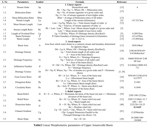
Table 1 Morphometric parameters of Upper Amaravathi Basin with formula
S. No Parameters Symbol Formula Reference
1. Linear aspects
1.1 Stream Order Sμ Hierarchical rank [13] 6
1.2 Bifurcation Ratio Rb
Rb = Nμ / Nμ +1, Where, Rb = Bifurcation ratio, Nμ = No. of stream segments of a given order and Nμ +1= No. of stream segments of next higher order.
[15]
1.3 Mean Bifurcation Ratio Rbm Rbm = Average of bifurcation ratios of all orders [13]
1.4 Stream Length Lμ Length of the stream (kilometers) [5] 147.2217km
1.5 Mean Stream Length Lsm Lsm = Lμ/Nμ, Where, Lμ = Total stream length of order ‘μ’
Nμ = Total no. of stream segments of order ‘μ’
[13]
1.6 Stream Length Ratio RL RL = Lsm / Lsm¯¹, Where, Lsm =Mean stream length of a given order and Lsm¯¹= Mean stream length of next lower order [5]
1.7 Length of Overland Flow Lg Lg =1/2D Km, Where, D=Drainage density (Km/Km2) [5] 0.20932km
1.8 Basin Perimeter P P=Outer boundary of drainage basin measured in kilometers. [15] 413.655km
1.9 Basin Length Lb Lb =1.312×A [15] 115.0941km
2 .Areal aspects
2.1 Basin Area A Area from which water drains to a common stream and boundary determined
by opposite ridges. [13] 5030.69km²
2.2 Drainage Density Dd
Dd = Lμ/A, Where, Dd = Drainage density (Km/Km2) Lμ = Total stream length of all orders and
A = Area of the basin (Km2).
[18] 2106.04/5030.69= 0.41864km/km²
2.3 Drainage Frequency Fs
Fs = Nμ/A, Where, Fs = Drainage frequency. Nμ = Total no. of streams of all orders and
A = Area of the basin (Km2).
[18] 10468/5030.69=2.08 08/ km²
2.4 Infiltration Number If If = Dd × Fs, Where, Dd = Drainage density (Km/Km2) and
Fs = Drainage frequency.
[37] 0.41864x2.0808=0.8 711
2.5 Drainage Texture Dt Dt = Nμ /P, Where, Nμ = No. of streams in a given order and P = Perimeter
(Kms) [5, 38]
2.6 Form Factor Ratio Rf Rf = A/ Lь², Where, A = Area of the basin and
L ь = (Maximum) basin length [18]
5030.69/13246.6518 =0.37977
2.7 Elongation Ratio Re Re= √A /π / Lь, Where, A= Area of the basin (Km2)
Lь =(Maximum) Basin length (Km)
[15]
0.1961
2.8 Circularity Ratio Rc Rc = 4πA/ P², Where, A = Basin area (Km2) and
P= Perimeter of the basin (Km) [34] 0.3694
3. Relief Aspects
3.1 Basin Relief H H = Z – z, Where, Z = Maximum elevation of the basin (m) and z = Minimum
elevation of the basin (m)
[39]
2505-180=2325ms
3.2 Relief Ratio Rr Rr = H / Lь, Where, H = basin relief (m) and
Lь = Basin length (m)
[15] 2505/115.0941=21.7 648 = .021
3.3 Dissection Index D D = H / Ra, Where, H = basin relief (m) and
Ra = Absolute relief (m)
[40] 2325/20=116.25
0.11625
3.4 Channel Gradient Cg
Cg = H / {(π/2) × Clp}, Where, H = basin relief (m) and Clp= Longest Dimension Parallel to the
Principal Drainage Line (Kms) =Lb
[41]
12.8596m/km
3.5 Basin Slope Sb Sw = H / Lb [38] 20.2008/100=
.202008
Table2 Linear Morphometric parameters of Upper Amaravathi Basin
Stream Order
(Sμ)
Stream number (Nμ)
Bifurcation ratio (Rb)
Stream length (Lμ) (kms)
Mean stream length (Lsm) (kms)
Cumulative Mean stream length (Lsm)
Stream length ratio (RL)
Mean bifurcation ratio (Rbm)
I 7989(76.31) 508.89(24.16) 0.064 0.064
4.146
4.23 1.45
II 1860(17.77) 174.01(8.26) 0.093 0.157
3.89 20.107
III 478(4.6) 893.40(42.42) 1.87 2.027
4.23 1.754
IV 113(1.08) 370.97(17.61) 3.28 5.307
5.38 1.496
V 21(0.201) 103.20(4.9) 4.91 10.217
3.0 1.617
VI 7(0.07) 55.57(2.64) 7.94 18.157
Morphometric Studies of the Upper Amaravathi Basin
Linear Morphometric Parameters
The morphometric parameters of linear scale are governed by the channel patterns of the drainage network reflecting the topography of the basin (Table 2).
Stream order (Sμ)
Stream ordering is the first step in the process of morphometric analysis of a Basin. Strahler`s (1964) ordering scheme is followed in this study. The Upper Amaravathi Basin is a Sixth Order drainage basin (Fig 1). Lower order streams feed the higher order stream to form the main stream (River Amaravathi) with discharge of rainwater during seasonal precipitation.
Stream Number (Nμ)
The number count of stream channels of a given order is known as stream number.
The morphometric studies of the basin has shown Amaravathi river has 10468 streams linked to 6 orders as shown in the Figure (1) Covering an area of 5031 Sq.Km. Stream
frequency decreases as the stream order increases. Stream number is directly proportional to the basin size and with the dimensions of the channel (Table 2). Higher stream number is indicative of decrease in permeability and infiltration. The stream order – stream number relationship (Fig 2) returns a negative correlation between stream order and stream number informing a geometrically decreasing stream numbers with an increase of stream order. The complex variability of the underlying structure and geology of the basin results in this negative correlation between stream order and stream number.
Bifurcation Ratio (Rb)
The branching pattern of the drainage network is closely related to the Bifurcation ratio of the basin (15). The bifurcation ratio of the basin varies from 3.0 to 5.38 (Table 2). The possibilities of varying basin geometry, lithology and structure may be responsible for this variability. The mean bifurcation ratio is 4.146. The highest bifurcation ratio (Rb)
5.38 is found between IV and V order streams indicating highest overland flow may be because of less permeable rock formations underlying the region. The slope of the region also is of higher gradient configuration. The high bifurcation ratio indicates a possible potential for flash floods during storm events, where these stream orders dominate (16,17). The relatively lower bifurcation ratio existing between stream orders II and III, and V and VI informs a high permeability, greater geological heterogeneity and relatively lesser structural control in the area.
Stream Length (Lμ)
The relief and lithology of the basin is indicated by the stream length of various stream orders. The III order stream has the maximum stream length of 893.4 followed by I order stream with stream length of 508.89. IV order stream has 113 stream segments running to a length of 370.97. The II, V and VI order streams have stream lengths of 174.01, 103.2 and 55.57 respectively (Table 2), (Fig3). Stream lengths of different orders indicate the structural and tectonic precedence’s of the basin in the developments of the stream segments. Stream orders I and II traverse high altitude regions of the basin, while stream order III is located on zones of moderate slope. Stream segments of IV, V and VI orders flow through plain land regions. The irregularity observed in the stream lengths for successive stream orders inform heterogeneous basin geometry and lithological characteristics of the basin.
Stream Length Ratio (RL)
The stream length ratio has an important relationship with surface flow, discharge and erosion characteristics of the basin (5, 17). The very great difference in the stream length ratio (20.107) seen between II and III orders indicate a sudden decrease in the slope and altitude between the regions of these stream segments. The nominal changes seen between the remaining orders of the Upper Amaravathi Basin from one to other informs the basin is characterized by early mature stage of valley development from a very late youthful stage of the drainage (18).
Length of Overland Flow (Lg)
The physiographic, hydrologic and lithologic development of drainage basins is best understood from the morphometric character, Length of Overland Flow (Lg), (19). Overland flow
of a basin is affected significantly by infiltration or
Table3 Drainage Texture table
Stream Order (Sμ)
Stream number
(Nμ) Perimeter
Drainage Texture Dt = Nμ /P
I 7989(76.31) 413.655 19.3131
II 1860(17.77) 4.4965
III 478(4.6) 1.156
IV 113(1.08) 0.2731
V 21(0.201) 0.5076
VI 7(0.07) 0.01692
Total 10468 25.3061
Fig 2 Stream Order – Stream Number Relationship
Fig 3 Stream Order – Stream Length Relationship
0 2000 4000 6000 8000 10000
1 2 3 4 5 6
S tr e a m N u m b e r
Stream Order-Stream Number Relationship 0 100 200 300 400 500 600 700 800 900 1000
1 2 3 4 5 6
S tr ea m L en g th (K m )
percolation through the top soil layers (20, 17). The length of overland flow of the study basin is 0.21 kilometres, showing gentle slopes in the valleys resulting in low surface runoff and longer river flow segments.
Fitness Ratio (Rf)
The ratio between main channel lengths to the basin perimeter is fitness ratio of a basin. Fitness Ratio expresses the topographic fitness (21) of the basin. The fitness ratio of upper Amaravathi Basin is 0.35.
Wandering Ratio (RW)
The wandering ratio of Upper Amaravathi Basin is 1.2. It is the ratio of the main stream length to the valley length or basin length (21).
Standard Sinuosity Index (SSI)
The standard sinuosity index of the basin is 1.2 and shows a
winding course of the river Amaravathi. It is a significant morphometric parameter for quantifying the stream significance in the evolution of the landscape of the basin. The index also signifies the effect of terrain characteristics on the river course.
Areal Morphometric Parameters
The geomorphic considerations of a river basin start with the quantifiable studies on Area of the Basin (A) and perimeter (P) of the basin. The area of the basin influences the size of storm hydrograph, magnitudes of peak and mean runoff. The maximum flood discharge per unit area of a basin is inversely related to its size (22). The area covered by Upper Amaravathi Basin is 5030.69 km2. The areal morphometric parameters of the study area are given in Table 1.
Drainage density (Dd)
The measurement of Dd is a useful numerical measure of
landscape dissection and runoff potential of a basin (23). A high drainage density reflects a highly dissected drainage basin with a relatively rapid hydrological response to rainfall events, while a low drainage density means a poorly drained basin with a slow hydrologic response (21). Drainage density is the quantitative measure of the interactive factors controlling the surface runoff that influence the output of water and sediment from the basin (24). Dd varies with the soil
and rock (26) properties of the basin along with the variations in the climate, vegetation (25), relief and landscape evolution processes of the basin. The drainage density determines the time travel by water on the basin (15). Thus the hydrology of the basin changes significantly as a response to the changes in the drainage density of the basin.
The drainage density of the study area is a low 0.41864km/km² indicative of low permeability, sparse vegetation cover and a low relief (27) with a moderate infiltration and a moderate recharge to the ground aquifers.
Drainage frequency (Fs)
The drainage frequency or stream frequency of a drainage basin depends on the lithology of the basin and is a reflectance to the texture of the drainage. It also indicates the different stages of landscape evolution of the basin. The stream frequency depends on the rock structure, infiltration, vegetation cover and relief, amount of rainfall and permeability of the subsurface strata. The drainage frequency
of Upper Amaravathi basin is 2.08/km2. Sparse vegetation, low relief, medium to low infiltration capacity and low runoff are characteristic of the basin reflected by the stream frequency. Moderate correlation occurs between the two parameters of Drainage frequency and Drainage density.
Drainage texture (Dt)
Natural factors like vegetation type and density, types of rock and soil, infiltration capacity, climate, relief and stage of development of drainage define the drainage texture of a basin (30) (Table 3). Low drainage density leads to coarse drainage texture while high drainage density leads to fine drainage texture (25), that depend on the infiltration capacity of the bedrock or the underlying strata (31). The drainage texture values of the Upper Amaravathi basin are
The basin has two different sets of drainage texture in accordance with the altitude of the location of the stream orders. The drainage texture is coarse to moderate with medium permeability, lower run off rate and moderate to good recharge of the groundwater of the basin except in the area drained by the first and second order streams.
Infiltration Number (If)
The infiltration number of the study area basin is 0.8711. Infiltration number informs us on the infiltration capacity of the basin and has a inverse relationship with the infiltration potential of the basin. The very low infiltration number indicates a very low runoff with good infiltration capacity of the basin, provided the topsoil and weathered strata have good permeability.
Form factor ratio (Rf)
The form factor ratio of the Upper Amaravathi basin is 0.37, indicating an elongated shape basin. Area, perimeter and basin length are used to calculate this parameter of a dimensionless character (32), which has a great influence on the water flow characteristics of the river. Long, flat stream segments aid in longer durations of peak flow, easily manageable for hydrogeological purposes.
Elongation ratio (Re)
Form factor and elongation ratio go together in explaining the hydrological character of a basin. The hydrological response of a basin to varied basin morphology is similar with elongation ratio and form factor ratio (13, 34). The elongation ratio of the upper Amaravathi basin is 0.19 indicating a moderate relief relative to the elongated shape of the basin.
Circularity ratio (Rc)
The circularity ratio is a quantitative parameter used in explaining the shape of the basin (35, 13). The subsurface character of lithology influences the circularity ratio of a basin. The ratio is more influenced by length, frequency and gradient of the streams of various orders rather than the slope conditions and drainage pattern of the basin. The circularity ratio of 0.37 indicates a elongated basin with low relief
STREAM ORDER (Sμ) DRAINAGE TEXTURE (Dt)
I 19.3131
II 4.4965
III 1.156
IV 0.2731
V 0.5076
influenced by the structural characteristics of the basin (30, 36).
Relief Morphometric Parameters
Area, volume and altitude of landforms are used to understand the relief aspects of a basin. Relief features are used in understanding the geohydrological characteristics of a basin (Table 1).
Relief ratio (Rr)
The relief ratio of the upper Amaravathi basin is 0.021 indicating a low relief and a relatively moderate slope. Relief ratio measures the overall steepness of a drainage basin and is an indicator of the intensity of erosion processes operating on the basin (15).
Basin relief (H)
The morphometric parameter basin relief informs the landform characteristics and the geomorphic processes that are in action in the basin (Fig 4). The study area has a basin relief of 2.325 km.
Dissection index (DI)
Dissection index is a parameter that implies the degree of dissection or vertical erosion and expounds the stages of terrain or landscape development in any physiographic landform or basin (32, 36). The dissection index of the basin is 0.11 indicating poorly dissected plains, exception to the regions of first order streams.
Channel gradient (Cg)
The mean downstream decrease of the upper Amaravathi basin surface is 12.86 m/km. The mean channel slope decreases with the increasing stream order number. The upper Amaravathi basin best signifies the Horton`s law of stream slopes explaining the slope of streams and their orders, given by the inverse geometric series law. High altitude mountainous streams of lower orders show a greater stream slope to a minimal fall in the plains of higher stream orders.
Basin slope (Sb)
The assessment of runoff generation, direction and volume of a basin is enabled by the parameter basin slope (37).
The basin slope of the basin is 0.21. The basin has a planar character with gentle to very low slope. A relatively lower percentage of the stream flows in the high altitude mountainous terrain and a major stream channel flows through plains. The slope of the stream decreases towards north-northeast (Fig 5).
Identification of Groundwater Potential Zones
Quantitative morphometric parameters studied along with geological, lithological, structural and topographical setting of a region is helpful in analysing the geo-hydrological conditions of the region towards the location of groundwater potent zones (38, 39). Amaravathi River is an ephemeral river supporting surface flow only during monsoonal precipitation. Hence groundwater is the main source for irrigation and nearly 90% of the agricultural lands are fed by groundwater. The geology of the area is of hard rock represented by Migmatite gneisses and Charnockites (Fig.6). The shallow aquifers of the region pierced through dug wells
are over exploited at some blocks and most of the blocks are at a critical stage of groundwater extraction with more than 85% of the annual recharge. When a weak monsoon without normal or below it happens, the aquifers suffer overdraft, forcing the aquifer managers to sink deep bore wells to tap the bank storage.
Morphometric parameters like drainage density, stream frequency, drainage texture, infiltration number, length of overland flow, bifurcation ratio, basin relief, basin slope along with rate of runoff, percolation, infiltration, overland flow are used in the evaluation the groundwater potential of a basin.
High groundwater potential zone
The flood plains formed by the river are characterised by sandy and clayey soil overlying the charnockite and gneissic subsurface rocks (Fig 4). The weathered and permeable rocky aquifers along the flood plains have a good to moderate ground water potential. This part of the basin is dominated by 4, 5, and 6th order streams. The region has low relief and
gentler slope. The general altitude is about 180 to 340 m amsl. The region has numerous dugwells and is thickly populated along with agricultural fields with good to moderate groundwater availability.
Moderategroundwater potential zone
The regions other than the flood plains of the stream have a moderate groundwater potential. The region is mostly drained by 2nd and 3rd order streams, with high drainage density, moderate slope medium drainage texture and infiltration number. The region has red and brown soil, red and brown loamy soil, black soil, red soil and clayey soil. The region has a relatively moderate relief and the general altitude is about 500 to 340 m amsl. The dugwells of the region have relatively lesser recharge potential due to their morphometric characters.
Low groundwater potential zones
The mountainous area drained by 1st and 2nd order streams with a general altitude of 2500m to 500 m amsl are covered by forests and are hilly terrain. The region is covered by red and brown soil and has steep slope with greater runoff during
rains. The region has high drainage density and low drainage texture indicative of low permeability.
CONCLUSIONS
The recharge of groundwater of a region is governed by multiple factors and the identification of recharge potential zones using morphometric parameters forms the preliminary assessment for delineation of groundwater potential of the study area. The morphometric studies of the upper Amaravathi basin resulted in the topographic and geomorphic understanding of the basin. The quantitative analysis of the basin on areal, relief and linear aspects has given the necessary morphometric inputs for the geological understanding of the basin.
The Amaravathi River has formed a sixth ordered basin. The basin has a later matured stage of valley development and has two clear drainage divisions of I and II order streams along the mountainous terrain and higher order streams draining the plains. The moderate relief and very low slopes inform a very flat storm runoff with a good to moderate groundwater recharge.
The good ground water development and potential zones are seen along the river plain zones dominated by sandy and clayey soils.
References
1. Agarwal CS (1998) Study of drainage pattern through aerial data in Naugarh area of Varanasi district U.P. Journal of the Indian Society of Remote Sensing 26: 169-175
2. Obi Reddy GP, Maji AK, Gajbhiye KS (2002) GIS for morphometric analysis of drainage basins. Geological Survey of India 11: 9-14.
3. Horton RE (1940) An approach towards physical interpretation of in ltration capacity. Proceedings of the Soil Science Society of America 5: 399-417. 4. Strahler AN (1950) Equilibrium theory of erosional
slopes, approached by frequency distribution analysis. Am Jour Sci 248: 800-814.
5. Horton RE (1945) Erosional Development of streams and their drainage basins, Hydrophysical approach to quantitative morphology. Geological Society of American Bulletin 56: 275-370.
6. Strahler AN (1957) Quantitative analysis of watershed geomorphology. American Geophysical Union Transactions 38: 912-920.
7. Melton MA (1958) Correlation structure of morphometric properties of drainage system and their controlling agents. Journal of Geology 66: 442-460. 8. Pakhmode V, Kulkarni H, Deolankar SB (2003)
Hydrological drainage analysis in watershed programme planning, A case study from the Deccan basalt, India. Hydrogeology Journal 11: 595- 604. 9. Gangalakunta P, Amal K, Kothiram S (2004) Drainage
morphometry and its influence on landform characteristics in a basaltic terrain, Central India – a remote sensing and GIS approach. Int J Appl Earth and Geoinformatic 6: 1-16.
10. Rastogi RA, Sharma TC (1976) Quantitative analysis of drainage basin characteristics. Jour Soil and water Conservation in India. 26: 18-25.
11. Mesa LM (2006) Morphometric analysis of a subtropical Andean basin (Tucumam, Argentina). Environmental Geology 50: 1235-1242.
12. Rafiq Ahmad Hajam et.al (2013) Application of Morphometric Analysis for Geo- Hydrological Studies Using Geo-Spatial Technology – A Case Study of Vishav Drainage Basin. J Hydrology Current Research 2013, 4:3
13. Strahler AN, Chow VT (1964) Quantitative geomorphology of drainage basins and channel network, In. Handbook of Applied Hydrology, McGraw Hill Book Company, New York, USA. 14. Strahler AN, Strahler AH (2002) A Textbook of
Physical Geography, John Wiley and Sons, New York.
15. Schumn SA (1956) Evolution of drainage systems and slopes in badlands at Perth Amboy, New Jersey. Geological Society of American Bulletin 67: 597-646 16. Rakesh K, Lohani AK, Sanjay CC, Nema RK (2000)
GIS based morphometric analysis of Ajay river basin up to Sararath gauging site of south Bihar. J Appl Hydrol 14: 45-54.
17. Kanth TA, Hassan ZU (2012) Morphometric Analysis and Prioritization of Watersheds for Soil and Water Resource Management in Wular Catchment Using Geo-Spatial Tools. International Journal of Geology, Earth and Environmental Sciences 2: 30-41.
18. Singh S, Singh MC (1997) Morphometric analysis of Kanhar river basin. National Geographical Journal of India 43:31-43.
19. Horton RE (1932) Drainage basin characteristics. American Geophysical Union of Transactions 13: 350-361.
20. Schmid BH (1997) Critical Rainfall Duration for Overland Flow an Infiltrating Plane Surface. Journal of Hydrology 193: 45-60.
21. Melton MA (1957) An analysis of the relation among elements of climate, surface properties, and geomorphology. Department of Geology, Columbia University, New York, USA.
22. Smart S, Surkan AJ (1967) The relationship between mainstream length and area in drainage basins. Water Resources Research 3: 963-973.
23. Chorley RJ, Donald EG Malm, Pogorzelski HA (1957) New Standard for Estimating Drainage Basin Shape. American Journal of Science 255: 138-141. 24. Chorley RJ (1969) Introduction to Physical Hydrology.
Suffolk, Methuen and Co. Ltd.
25. Ozdemir H, Bird D (2009) Evaluation of morphometric parameters of drainage networks derived from topographic maps and DEM in point of floods. Environmental Geology 56: 1405-1415.
26. Moglen GE, Eltahir EA, Bras RL (1998) On the Sensitivity of Drainage Density to Climate Change. Water Resource Research 34: 855-862.
27. Kelson KI, Wells SG (1989) Geologic influences on fluvial hydrology and bed load transport in small mountainous watersheds, Northern New Mexico, US. Earth Surface Processes and Landforms 14: 671-690. 28. Nag SK (1998) Morphometric analysis using remote
sensing techniques in the Chaka Sub-basin, Purulia District, West Bengal. Journal of Indian Society of Remote Sensing 26:69-76.
29. 29. Carlston CW (1963) Drainage density and streamflow, U.S Geological Survey Professional Paper.
30. KaleVS, Gupta A (2001) Introduction to Geomorphology. Orient Blackswan Private Limited. 31. Smith GH (1939) The Morphometry of Ohio, the average slope of the land (abstract). Annals of the Association of American Geographers 29: 94.
32. Thornbury WD (1969) Principles of Geomorphology. 2nd edition, Wiley and Sons, New York, USA. 33. Singh S (1998) Geomorphology. Prayag Pustak
Bhawan, Allahabad.
International Journal of Water Resources and Environmental Engineering 5: 489-498.
35. Christopher O, Idown AO, Olugbenga AS (2010) Hydrological analysis of Onitsha north east drainage basin using Geoinformatic techniques. World Applied Science Journal 11: 1297- 1302.
36. Miller VC (1953) A Quantitative Geomorphic Study of Drainage Basin Characteristics in the Clinch Mountain Area, Virginia and Tennessee. Department of Geology, Columbia University.
37. Zavoiance I (1985) Morphometry of drainage basins (Developments in water science), Elsevier Science, New York, USA.
38. Pareta K, Pareta U (2011) Quantitative Morphometric Analysis of a Watershed of Yamuna Basin, India using ASTER (DEM) Data and GIS. International Journal of Geomatics and Geosciences 2: 251-265. 39. Rudraiah M, Govindaiah S, Vittala SS (2008)
Delineation of potential groundwater zones in the Kagna river basin of Gulburgadistrict, Karnataka, India using remote sensing and GIS techniques. MAUSAM, 59: 497-502.
40. Magesh NS, Chandrasekar N, Soundranayagam JP (2012) Delineation of groundwater potential zones in Theni district, Tamil Nadu, using remote sensing, GIS and MIF techniques. Geoscience Frontiers 3: 189-196.
41. Prasad RK, Mondal NC, Banerjee P, Nandakumar MV, Singh VS (2008) Deciphering potential groundwater zone in hard rock through the application of GIS. Environmental Geology 55: 467-475.
42. Faniran A (1968) The Index of Drainage Intensity - A Provisional New Drainage Factor. Australian Journal of Science 31: 328-330.
43. Smith KG (1950) Standards for grading texture of erosional topography. Am J Sci 248: 655-668. 44. Strahler AN (1952) Dynamic basis of geomorphology.
Bulletin of the Geological Society of America 63: 923-938.
45. Singh S, Dubey A (1994) Geo-environmental planning of watersheds in India, Allahabad, India. Chugh Publications 28: 69.
46. Broscoe AJ (1959) Quantitative Analysis of Longitudinal Stream Profiles of Small Watershed. Project N. 389-042, Tech Rep 18, Geology Department, Columbian University, ONR, Geography Branch, New York, USA.