University of Pennsylvania
ScholarlyCommons
Publicly Accessible Penn Dissertations
Fall 12-22-2009
A METHODOLOGY FOR THE
DOCUMENTATION AND ANALYSIS OF
URBAN HISTORIC RESOURCES
Nicholas L. Stapp
University of Pennsylvania, [email protected]
Follow this and additional works at:http://repository.upenn.edu/edissertations
Part of theCultural Resource Management and Policy Analysis Commons,Historic Preservation
and Conservation Commons, and theUrban, Community and Regional Planning Commons
This paper is posted at ScholarlyCommons.http://repository.upenn.edu/edissertations/69 For more information, please [email protected].
Recommended Citation
Stapp, Nicholas L., "A METHODOLOGY FOR THE DOCUMENTATION AND ANALYSIS OF URBAN HISTORIC RESOURCES" (2009).Publicly Accessible Penn Dissertations. 69.
A METHODOLOGY FOR THE DOCUMENTATION AND
ANALYSIS OF URBAN HISTORIC RESOURCES
Abstract
The incorporation of historical data, issues and perspectives into the theory and practice of urban planning has yet to be fully embraced by the planning profession. Though scholars, practitioners and professional
associations have long attempted to do so, planners still struggle to develop effective tools for the
documentation, analysis, synthesis and presentation of historical information. Current practice often relies on the use of historical preservation strategies that are primarily oriented toward legislation and policy rather than physical planning.
This dissertation formulates and demonstrates a methodology that attempts to combine preservation planning strategies developed by the National Park Service with concepts from planning theory and practice in order to better enable physical planners to confront historical conditions and concerns. The methodology is embodied in the form of a survey instrument that is demonstrated by way of three digital cartographic models. The survey combines concepts from planning theory, preservation planning and mainstream practice in order to instruct, govern and classify collected data. The three models demonstrate the utility of this survey by using it to depict degrees of historic building significance and to represent the architectural compatibility of character-contributing features such as materials, patterns and styles. These models are applied to a mixed-use urban environment in the Washington Square area of Philadelphia. Results indicate that the survey instrument is effective and that the models yield interesting results.
Degree Type Dissertation
Degree Name
Doctor of Philosophy (PhD)
Graduate Group
City & Regional Planning
First Advisor Dr. C. Dana Tomlin
Second Advisor Dr. Eugenie L. Birch
Third Advisor Dr. Gary Hack
Keywords
Urban Design, Preservation Planning, GIS, Historic Resources, Urban Character, Sense of Place
Subject Categories
Cultural Resource Management and Policy Analysis | Historic Preservation and Conservation | Urban, Community and Regional Planning
A METHODOLOGY FOR THE DOCUMENTATION AND ANALYSIS
OF URBAN HISTORIC RESOURCES
Nicholas L. Stapp
A DISSERTATION
in
City and Regional Planning
Presented to the Faculties of the University of Pennsylvania
in
Partial Fulfillment of the Requirements for the
Degree of Doctor of Philosophy
2009
Supervisor of Dissertation
_____________________________________
Dr. C. Dana Tomlin, Professor of Landscape Architecture
Graduate Group Chairperson
_____________________________________
Dr. Eugenie L. Birch, Professor of Urban Research and Education
Dissertation Committee
Dr. Eugenie L. Birch, Professor of Urban Research and Education
Dr. Gary Hack, Professor of City and Regional Planning
A METHODOLOGY FOR THE DOCUMENTATION AND ANALYSIS
OF URBAN HISTORIC RESOURCES
COPYRIGHT
2009
iii
Acknowledgements
I would like to thank my dissertation supervisor, C. Dana Tomlin, whose conversations
have inspired and sustained me over the years. His guidance has been critical in
formulating and developing this research. I hope some portion of what I learned from
him is reflected here.
I owe a special debt of gratitude to my committee members, Eugenie L. Birch
and Gary Hack, for their excellent advice, kind guidance and thoughtful comments.
Special thanks are also due to Mark Davison, Eliot Foulds, Dr. Kostis Kourelis,
Anargiros Rentezelas, Dr. David Gilman Romano and Professor Mark Weidemaier.
Finally, I would like to thank my wife and son, Jill and Holden. This dissertation
would not have been possible without their smiles and sense of humor—this work is
iv
ABSTRACT
A METHODOLOGY FOR THE DOCUMENTATION AND ANALYSIS
OF URBAN HISTORIC RESOURCES
Nicholas L. Stapp
Dr. C. Dana Tomlin, Supervisor of Dissertation
The incorporation of historical data, issues and perspectives into the theory and practice
of urban planning has yet to be fully embraced by the planning profession. Though
scholars, practitioners and professional associations have long attempted to do so,
planners still struggle to develop effective tools for the documentation, analysis,
synthesis and presentation of historical information. Current practice often relies on the
use of historical preservation strategies that are primarily oriented toward legislation and
policy rather than physical planning.
This dissertation formulates and demonstrates a methodology that attempts to
combine preservation planning strategies developed by the National Park Service with
concepts from planning theory and practice in order to better enable physical planners to
confront historical conditions and concerns. The methodology is embodied in the form
v
The survey combines concepts from planning theory, preservation planning and
mainstream practice in order to instruct, govern and classify collected data. The three
models demonstrate the utility of this survey by using it to depict degrees of historic
building significance and to represent the architectural compatibility of
character-contributing features such as materials, patterns and styles. These models are applied to
a mixed-use urban environment in the Washington Square area of Philadelphia. Results
indicate that the survey instrument is effective and that the models yield interesting
vi
TABLE OF CONTENTS
I Introduction 1
1.1 Overview 1
1.2 Thesis and Intellectual Contribution 3
1.3 Methodology 4
II Literature Review 6
2.1 Rethinking the Urban Form 6
2.2 Influential Pioneers of Theory and Application 9
2.3 NPS: Bringing Preservation into Planning 22
2.4 The Use of Historic Resources in Planning in 2009 30
2.5 Conclusion 38
III Survey Design and Implementation 41
3.1 Early Survey Design 41
3.2 Early Survey Application 47
3.2.1 Study Area Specifics 48
3.2.2 Identifying Areas for Improvement 56
3.3 Survey Implementation 59
IV Model Design and Implementation 61
4.1 Three Urban Planning Scenarios 61
4.2 Methodology 63
4.2.1 Model 1—Change-Over-Time 66
vii
4.2.3 Model 3—Architectural and Character Compatibility 77
V Demonstration 85
5.1 Model 1—Change-Over-Time 86
5.2 Model 2—Historic Significance 90
5.3 Model 3—Architectural and Character Compatibility 98
VI Evaluation 103
6.1 Survey Evaluation 103
6.2 Evaluating the Models 105
6.2.1 Model 1—Change-Over-Time 106
6.2.2 Model 2—Historic Significance 107
6.2.3 Model 3—Architectural and Character Compatibility 109
VII Conclusion 111
Appendix A 112
Appendix B 119
Bibliography 137
viii
LIST OF TABLES
Table 4.1 Table showing the survey classifications used to construct the
ix
LIST OF ILLUSTRATIONS
Figure 2.1 The visual form of Boston, illustrating Lynch’s five elements 13 Figure 2.2 Serial vision as illustrated by Cullen, depicting aesthetic meaning,
movement and emerging views 15
Figure 2.3 Illustration depicting McHarg’s technique to classify the
landscape 18 Figure 2.4 Thirteen landscape characteristics as illustrated by the NPS 26
Figure 2.5 Survey form for evaluating the condition of the cultural landscape
as illustrated by the NPS 28
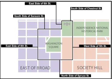
Figure 3.1 Boundary map of study area (outlined in black) with bounding
streets 48 Figure 3.2 Streetscape photograph depicting typical building heights,
materials and architectural styles of the Washington Square
area (looking west from 7th & Walnut St.) 49 Figure 3.3 William Penn/Thomas Holme plan of Philadelphia in 1682. (1)
locates Washington Square on the plan 50
Figure 3.4 This figure illustrates the kinds of information that detailed
chronological maps can provide in an urban planning study 54 Figure 3.5 Aerial photograph from 1965 depicting the dramatic changes to the
southeast and south central part of Washington Square. The area in yellow shows a surface parking lot and the area in orange shows the new Hopkinson House, newly created vacant lots and new
single family housing 55
Figure 3.6 Photographs of the buildings and streetscape recorded in the first application of the survey in the field. From left to right, the first two images are looking north on Walnut Street between 7th and 8th streets, while the third image is looking west on Walnut
Street from 7th to 8th street 57
Figure 3.7 Sample journal entry documenting the first test of the survey in
the field 58
Figure 3.8 The improved field survey map, with recorded classifications for
each building in the quadrant 60
Figure 4.1 Photographic montage of different architectural features from the
Washington Square area 65
Figure 4.2 (1) displays the non-extruded data of the southwest corner of the study area in 1916. (2) shows the same data extruded to its height
recorded from the 1916 map 67
Figure 4.3 Three-dimensional views exported to Adobe Flash. (1) represents 1916, (2) shows 1950, (3) depicts 2008 and (4) is a satellite image 68 Figure 4.4 A diagrammatic view of the final version of Model 2 in
x
Figure 4.5 The first segment of Model 2, (1) shows the creation and reclassification of four datasets, all showing the highest significance values in black, showing cultural condition (2),
PHC (3), NR (4) and historic significance (5) 72 Figure 4.6 The second and third segments of the distance/proximity analysis in
Model 2. (1) shows application of Euclidean distance, (2) illustrates the application of reclassify and cell statistics to produce (3), the final graphical representation of distance and proximity
of significance 73
Figure 4.7 The segment of Model 2 producing historic integrity. (1) shows the model and (2)displays the representation, with black features showing high levels of integrity and shades of gray showing
lower levels 74
Figure 4.8 The segment of Model 2 producing historic designation. (1) displays the model and (2) shows the representation, with black showing buildings with both NR and PHC designation and gray
showing features only with PHC designation 75
Figure 4.9 The segment of Model 2producing historic strength. (1) displays the model and (2) shows the representation, with black showing
high levels of strength and shades of gray showing lower levels 76 Figure 4.10 The segment of Model 2 producing historic significance. (1)
displays the model and (2) shows the representation, with yellow buildings representing the highest level; blue, medium; green,
low and purple, none 77
Figure 4.11 Model 3 as diagramed in ModelBuilder, documenting six unique
functions 78 Figure 4.12 (1) displays the first segment of Model 3 in ModelBuilder,
illustrating the reclassification of façade type (2), façade date (3)
and architectural style (4) 80
Figure 4.13 The second segment of Model 3 illustrating Euclidean distance in ModelBuilder on the left and the results of this analysis on the right. (1) and (3) represent façade date and type, while
(2) represents Federal architecture 81
Figure 4.14 The third segment of Model 3 in ModelBuilder showing the final operations for this segment and the final part of the model
identifying compatibility 83
Figure 4.15 The final segment of Model 3 in ModelBuilder displaying the cell statistics operation to produce an overlay of buildings used for
the analysis 84
Figure 5.1 “Serial vision” illustrating movement through time. This figure displays each scene in the animation, moving sequentially
xi
Figure 5.2 Example of a “high” value from Model 2 displaying historic significance. (1) displays the map of significant buildings; (2) displays the associated survey data and (3) is a photograph
of the significant building (the Reynolds-Morris House) 92 Figure 5.3 Example of a “medium” value from Model 2 showing historic
significance. (1) displays the map of significant buildings; (2) displays the associated attribute data; (3) is a photograph of the building in situ and (4) is a historic painting by Frank H. Taylor
of the area including the significant building 93 Figure 5.4 Example of a “low” value from Model 2 depicting historic
significance. (1) displays the map of significant buildings; (2) displays the associated attribute data and (3) is a photograph of
the building in situ 95
Figure 5.5 Example of a “none” value from Model 2 displaying historic significance. (1) displays the map of significant buildings; (2) displays the associated attribute data and (3) is a photograph
of the building in situ (on left) 96
Figure 5.6 The final map after running Model 2 in ModelBuilder displaying Federal-era buildings at different degrees of significance. (1) identifies the tool in ArcToolbox. (2) is the visual representation of significant buildings in reference to the study area circa
2008. (3) shows the table of contents in ArcMap 97 Figure 5.7 Example of a group of identified Federal buildings in Model 3, all
retaining their original brick façade. (1) identifies the cluster of buildings on the map. (2), (3) and (4) show the prevalence of
Federal-era brick buildings in this part of the study area 99 Figure 5.8 An example of how Model 3 identifies Federal-era buildings whose
façades have been dramatically altered. (1) shows the altered buildings in relation to unaltered buildings. Numbers (2), (3)
and (4) show the various kinds of alterations 100 Figure 5.9 The final map after executing Model 3 to display Federal-era
buildings with brick façades. (1) identifies the tool in ArcToolbox. (2) is the visual representation of compatibility analysis in
reference to the study area circa 2008. (3) shows the table of
1
I Introduction
1.1 Overview
Cities are increasingly demanding that planning and design take history, including
character, culture and meaning, into account. A number of factors are contributing to
this demand, including demographic shifts, which leave existing residents eager to
preserve the neighborhood; energy and climate challenges, which require creative reuse
of existing infrastructure; economic challenges, which can alter the character of an area;
and globalization pressures, which can threaten the individuality of a city (Hack in
Hack, Birch, Sedway & Silver 2009: 103).
Professional associations such as the American Planning Association (APA) and
the International City/County Management Association (ICMA) have also voiced a
desire for the integration of history as a resource for planning and design decisions. For
example, the APA has formulated a policy discussing the role and use of historic
resources,1 and both the APA and ICMA have created standards and techniques for
practice that refer to the importance of considering history when planning (APA Website
2009; Steiner & Butler 2007; Hack, Birch, Sedway & Silver 2009).2 Yet, while both
associations acknowledge the importance of a historical perspective, neither provide a
practical planning-focused method for the integration of history into mainstream
1
http://www.planning.org/policy/guides/pdf/historicandcultural.pdf
2
2
practice. Instead, both the APA and the ICMA recommend the use of preservation
planning strategies when considering historic resources in site planning and design.
While a useful first step, the use of preservation planning strategies does not
allow for the full integration of the resources of history into the planning and design
process. Its focus on documentation, legislation and policy leads to a static view that
isolates a particular building or neighborhood frozen at a particular time. In contrast to
the snapshot approach used by preservationists, planners require a flexible approach that
allows the urban form to be examined over time.
A growing number of scholars have recognized that a historical perspective can
offer a much richer understanding of the planned environment (Lynch 1960: 119; Lynch
1972: 49, 60, 242; Cullen 1996: 9-11; McHarg 1992: 79-93; Rapoport 1977: 12-14);
Relph 1976: 24, 35, 122, 146). These scholars have created new fields of study and
developed experimental methodologies that rely on the use of information associated
with people, activities, designs and buildings from the past as well as the present to
understand the factors that contribute to the structure of the urban form. Despite being
well received, their advances have not yet found their way into the mainstream planning
process.
This dissertation is therefore an attempt to create practical methods to integrate
the resources of history into the urban planning process. It develops a flexible survey
instrument that can be used to gather, classify and evaluate historical information about
buildings, blocks and neighborhoods at given moments in time. It further develops
models to demonstrate how the instrument might be used to query the historical
3
development. The successful demonstration of the survey and its models, based on
fieldwork in the area of Washington Square, Philadelphia, suggests that it has wide
applicability for integrating history into planning practice.
1.2 Thesis and Intellectual Contribution
This dissertation hypothesizes that a methodology rooted in theory and practice,
designed to document and analyze historic characteristics associated with the built
environment, could provide the practical solution needed by planners to more fully
integrate these resources into mainstream practice. Specifically, it employs a customized
survey derived from National Park Service (NPS) categories and three scenario-based
models designed to illustrate the utility of the survey. The survey combines concepts
from planning theory, preservation planning and mainstream practice to guide, regulate
and classify collected data. The three models depict urban scenarios showing the built
environment over time, the degree of significance a historic building possesses and the
architectural compatibility of character-contributing features such as materials, patterns
and styles.
This study tested and evaluated the survey and models on the mixed-use
environment surrounding Washington Square, Philadelphia to measure the ability of the
data to communicate meaningful historical information in a practical manner. This
associational process transformed buildings into layered bundles of information that
individually and/or collectively revealed distinct character-defining traits. The approach
4
a city’s character as it develops; adjusting, strengthening, introducing or removing
influences from the past in order to meet the needs of the residential population.
1.3 Methodology
The survey and models were developed with a multi-phase methodology. Planners and
planning-related literature increasingly employ multi-phase methodology in creating and
analyzing spatially sensitive, technically dependant data. Application of this
methodology permitted the survey and models to be created in four phases: design,
implementation, demonstration and evaluation.
In this project, the design phase included developing the preliminary survey,
including a list of classifications identifiable in the field; identifying scenario-based
models to illustrate the utility of the survey; calibrating the survey for usefulness,
practicality, and appropriateness; and preliminary field testing of the survey and
methodology.
In the second phase, implementation, finalized versions of the survey and the
models were proposed. Based on feedback from the design phase, the final version of
the survey included an abbreviated set of classifications and a refined data-gathering
technique. The demonstration phase showed the utility of the survey to mainstream
practice and the effectiveness of the models in communicating meaningful historical
information. Finally, the evaluation phase examined the design, functionality and
5
evaluation phase identifies successes, failures and anticipated and unanticipated
6
II Literature Review
Over the past forty years, planning scholars’ attitudes about the urban form have evolved
from an insistence of physical planning toward a public-oriented planning. This
philosophical transformation has affected both thought and practice, so that
contemporary planners’ understanding of the city and its environs draws insights from
anthropology, architecture, geography, landscape architecture, political science,
preservation, psychology, and sociology. Planners have moreover also begun to take
account of users’ perspectives by exploring time, motion, place, ecology, and the
aesthetic in addition to their traditional concerns with the physical form of the city. This
scholarly diversity is reflected in the vast assortment of theories and analytical
techniques used to capture and represent these new types of data.
This dissertation’s focus on the uses of resources derived from history draws on
this increasingly diverse field of study. This literature review explores the works of key
scholars’ whose notions of space, place, and community are especially relevant for this
work.
2.1 Rethinking the Urban Form
The 1960s were a critical time for the American planning community, as political
pressure, social unrest and economic demands would ultimately force it to shift from its
traditional focus on physical planning of the city and region to planning for the
7
Although a variety of social and political factors affected the theory and practice
of planning in the 1960s, major population shifts, the civil rights movement, widespread
activism and the large-scale modification of cities and the countryside were particularly
critical (Birch in Krueckeberg 1983: 142).3 Until this point, planning theory had
consisted primarily of a handful of theoretical approaches, many of which were rooted in
the Utopian ideals of the “old planning system” (Hall 2002: 359). Of these highly
regarded (and sometimes still used) theoretical approaches to planning, the four most
important were Marxism (1848—Marx & Foglesong & Harvey)4,
Rational-Comprehensive (1900)5, Spatial (1927)6 and Incrementalism (1950—Lindblom &
Meyerson and Banfield)7. Rational-Comprehensive and Spatial planning theory were
particularly popular, most likely because their techniques were most applicable to the
physical planning of land. The efficiency and logic of these approaches added to their
appeal for planners, with much of their application applied to projects for local, state and
federal governments.
None of these theoretical approaches took into account the consideration of
historic features of the neighborhood, city or region. Historic preservation activities,
which might include surveying, documenting and listing historic resources to protect
3
The Civil Rights Act was passed in 1964, making it illegal to discriminate by race, creed or national origin in public places.
4
Based on the writings of Karl Marx, this theory argues that, in principle, the enhancement of society will only occur if institutions that manipulation of the labor force are eliminated, replacing them with social institutions which serve all.
5
Commonly thought of as the “general theory of planning,” rational-comprehensive planning applies rational decision making to planning to reveal solutions to identified problems. The four basic principles are goal setting; identification of policy alternatives; evaluating the means against ends and the
implementation of decisions with feedback loops and repetition of steps.
6
This theory proposes that planning is an intermingled collection of spatial information representing social and physical space. This approach became popular within comprehensive and regional planners.
7
8
against their demolition and development (Mason in Hack, Birch, Sedway & Silver
2009: 132), were generally led by members of the public, rather than the planning
community. Few planners associated the notion of preservation with the built
environment, with their approach instead shifting toward a theory and practice of social
and economic planning (Hall 2002: 359, 366). The irony is that there is an intrinsic
connection between the social and economic characteristics of the city and its historic
and residential character.
The two were particularly related in the years immediately following World War
II, when the federal government was under tremendous pressure to launch nationwide
planning and construction campaigns of houses, federal highways and municipal
facilities.8 The sheer volume of development made some loss in historic character nearly
inevitable. In addition, during the Great Depression and then the war, many existing
cities had neglected infrastructure, housing, municipal facilities, mass transit and
recreational facilities. The federal government led many initiatives to repair, redevelop
and modernize the country by funding local, state and federal planning agencies to
undertake these renewal campaigns. Many cities were in dire need of resources to
remedy their social, economic, political and structural issues and were more than willing
to participate in many of the governmental programs. For example, cities like Houston,
Pittsburgh, Denver, Chicago and New York all participated in various governmental
8
9
programs to modify, standardize and modernize their cities (Scott 1969: 597).9
Combined with political upheaval and criticism from the public, this high volume of
activity forced the planning profession to rethink its role, ultimately rebranding itself as
an advocate for the public.
Three prominent theoretical models appeared in the wake of this tumultuous
philosophical transformation: the planner as democrat; the planner as informal
coordinator and the probabilistic planner (Hall 2002: 365). These models offered
different techniques that ultimately diverged to reveal the new focus of the profession: to
“contribute to the public well-being by developing communities and environments that
meet the needs of people and of society more effectively” (Hall 2002: 366, 367). This
new perspective allowed planners to step away from traditional methods of theory and
analysis to develop new theories and techniques that would contribute to and promote
residential well-being while also allowing them to explore the non-traditional city to
determine what makes a city unique, interesting and meaningful. Specifically, planners
began to recognize a wide variety of new urban resources: history, character, place, the
aesthetic, culture and residential perception.
2.2 Influential Pioneers of Theory and Application
In 1943, sociologist and ethnographer William F. Whyte’s Street Corner Society
proposed a new theoretical methodology to analyze the complex, stratified layers of
urban social existence. This scholarly work chronicled the lives of an Italian-American
9
10
community living in a depressed part of the North End in Boston (Massachusetts) over a
three-year period. One of the primary research objectives of this study was the
identification of characteristics associated with the social structure of the community in
an attempt to determine what actions (social, financial and political) might help the
community rise from its depressed situation (high rates of crime, unemployment, poor
infrastructure and political corruption), theorizing that change would only be successful
if it was directed toward the real needs of the residential population instead of
generically imposed upon them by the government. Whyte’s research methodology
evolved as the study progressed, originally starting as a quasi socio-anthropological
study (relying on interviews and analysis) and gradually becoming a study that
combined traditional data resources (census, crime statistics and housing/welfare
records) with non-traditional resources like residential observations and
participant-observation. Whyte’s work was revolutionary not only for its content, but also for its
flexible approach to methodology that drew on insights from a number of different
disciplines and developed as the project was lived. Whyte’s work created the notion of
community involvement in decision-making, recognizing that the social qualities of a
community are as valid a resource for study as other more traditional resources.
A central contribution of Whyte’s work is its recognition of the connection
between the social characteristics of the residential population and its relationship to
their local environs—an observation not fully realized by the planning community until
much later. In addition, Whyte’s research methodology was unique because it
incorporated the notion of time, site familiarity and peripheral site data. Whyte thought
11
insights into research questions, while also revealing answers to questions that would
otherwise be difficult to resolve (Whyte 1993: 303). Another methodological
development centered on the notion of site familiarity. Whyte theorized that successful
site research can only be achieved after the researcher becomes intimately familiar with
the site before any research is conducted (Whyte 1993: 303). A final noteworthy
methodological advance theorized that the use of peripheral data (recorded data not
directly related to the research objective) provides the researcher with the ability to
understand the “larger structure of the community” (the so-called big picture) by relating
his work to the city in which the community resides (Whyte 1993: 324). Whyte’s
methodological approach was revolutionary for its time, essentially creating the field of
urban sociology.
In The Image of the City (1960), urban designer and planner Kevin Lynch
followed the premise of planning for the betterment of the community by promoting the
theory of “imageability.” As Lynch defined it, imageability is “that quality in a physical
object which gives it a high probability of evoking a strong image in any given observer.
It is that shape, color, or arrangement which facilitates the making of a vividly
identified, powerfully structured, highly useful mental images of the environment”
(Lynch 1960: 9). Lynch proposed that it was possible to document and analyze
information contained within the minds of city residents—their mental image—when
considering distinctive and memorable elements from their environs. Used correctly, this
form of analysis offered a means to perceive the legibility of the city through the eyes of
its residents (Lynch, Banerjee and Southworth 1990: 239). Lynch suggested that some
12
into either sequential or spatial patterns for analysis to reveal routes, buildings, locations
and natural elements which contribute to the residential perception of place (Appleyard
1970: 114). Lynch theorized that identifying concentrations of these image-contributing
elements would allow the planner to map areas containing the community’s most and
least significant perceptual resources, thereby creating a plan that retains an organized
environment while deemphasizing less significant resources. For Lynch, this approach
creates a stronger sense of place, permitting residents both new experiences and a level
of comfort (Lynch 1960: 9).
Lynch’s methodology combined traditional data recording techniques (field
survey and mapping) with non-traditional resources and techniques (residential
surveys/interviews and cognitive mapping) to produce a new form of graphical
representation that combined the physical location of the study area with residential
perceptual information. Lynch tested this new planning paradigm with five elemental
components (paths, edges, districts, nodes and landmarks) that he theorized served as the
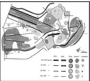
syntax that people use to orient themselves in cities (Lynch 1960: 47–48) (Figure 2.1).
This revolutionary methodological process displays some of the hallmarks of earlier
planning theory (Spatial and Incremental theory), but also proposes the use of
non-traditional resources. Moreover, his insistence on visual representation demonstrates the
viability of these non-traditional resources not only to the planning community but also
to the public at large (Lynch, Banerjee and Southworth 1990: 247).10 This early work
encouraged the planning community to think beyond the boundaries of traditional
10
practice and demonstrated that exploration of the intangible urban realm can make a
valid contribution to planning thinking and practice.
Figure 2.1 The visual form of Boston, illustrating Lynch’s five elements (source: Lynch 1960: 145, 147).
One year later, the architect and urban designer Gordon Cullen made a
monumental contribution to the architectural and planning communities with The
Concise Townscape (1961), which examined the art of the built environment and its
relationship to a cities residential population (Cullen 1996: 13-16). This revolutionary
study used a new approach to the relationship between space, the aesthetic, and the
resident to explore the aesthetic meaning of the urban form (Cullen 1996: 9, 10). Cullen
theorized that the urban landscape consisted of a series of related tangible (aesthetic) and
intangible spaces (meaning of the aesthetic) and proposed that the architect/planner will
produce a more meaningfully design if they understand the relationship between the
14
two. Cullen’s technique of “serial vision” identified and categorized aesthetic
components of the city, documenting the dynamic interplay between the collective form
and the space it occupies. Cullen’s approach emphasized the importance of the personal
and collective visual experience, theorizing that this form of information plays a central
role in creating a vital, vivid and successful city.
As did The Image of The City, The Concise Townscape explores the experiential
relationship between the resident and the city, classifying this relationship into three
categories: optics, place and content (Cullen 1996: 9–12). Cullen describes optics as the
concept of “serial vision” in which movement at a “uniform speed” through a city both
embraces an “existing view” and hints at possible “emerging views” down a winding
road or through a courtyard (Cullen 1996: 9) (Figure 2.2). Place is “concerned with our
reactions to the position of our body in its environment” (Cullen 1996: 9). This
locational awareness allows the resident to identify and sympathize with the
environment and facilitates meaningful navigation through the “here” and “there”
structures of the city (Cullen 1996: 10). Content refers to the aesthetic of place that
contains visual organization through “colour, texture, scale, style, character, personality
and uniqueness” (Cullen 1996: 11). Cullen theorized that these classifications help to
better understand the urban form, and, moreover, that their use demonstrates the
potential of non-traditional resources (architectural detail, natural features, enclosures,
relationships and scale) for informing a plan-making process that is sensitive to
Figure 2.2 Serial vision as illustrated by Cullen, depicting aesthetic meaning, movement and emerging views (source: Cullen 1996: 17).
The most outspoken proponent for an attitudinal shift within the planning
community was journalist, activist and urban visionary Jane Jacobs, who argued for an
inherent link between city residents and their environs in her publication The Death and
Life of Great American Cities (1961). Jacobs eloquently described how a city consists of
a collection of complex layers that make neighborhoods unique and argued that, by
ignoring these resources, planners fail to advocate for the common good of the public.
Largely in reaction to nationwide urban renewal initiatives from the period, Jacobs
strongly criticized both the planning community (specifically the rationalist planners)
and the disruptions their plans caused to cities throughout the United States. In this
groundbreaking work, Jacobs condemned planners for their reliance upon past planning
techniques, their ignorance to the multi-layered nature of the tangible and intangible city
16
(its neighborhoods, streets, sidewalks and aesthetic) and their disinterest in the
relationship between the city and its residents (Jacobs 1993: 4).Jacobs embraced
community involvement at every level in the plan-making process, forcing theorists and
practitioners to revise their concepts of what components are important to a city. As did
Lynch, Jacobs theorized that the community and the places they live—together—are
what makes streets, neighborhoods and cities unique and livable. This work, and the
public’s response to it, greatly influenced many members of the planning community,
forcing them to consider the ramifications of current planning practice, and ultimately
stimulating the adoption of a new public-oriented philosophy towards planning.
Yet a third book published in 1961, Lewis Mumford’s The City in History,
questioned the validity of traditional planning methods for understanding the structure
and function of cities. This monumental book reflected upon cities from a historical
perspective, relating these observations to the state of the city in the 1960s. Throughout
the text, Mumford presents an account of the global city in evolution, theorizing that
humans (the planning community) should look backwards to move forwards by applying
lessons from the past to address the present. Mumford observed that humans and cities
are inherently tied together and that this relationship should not be severed. He similarly
noted that the built environment of cities is inevitably shaped by time and the
preferences of the residents. When combined with insights from Jacobs and Lynch,
Mumford’s position contributed to the argument in favor of a form of
community-centered planning that would encourage residential involvement while also urging
professionals to be sensitive to the multitude of resources that contribute to a city’s
17
In 1969, landscape architect and planner Ian McHarg provided one of the most
significant contributions to modern site analysis since William F. Whyte with the
publication of his Design with Nature. Like other planners from the period, McHarg was
affected by the social, economic, political, industrial and developmental pressures of the
time, witnessing the wide-scale mistreatment of urban residents, urbanized areas and the
countryside. Cities were dirty, dangerous, poor, ghettoized and largely ignored.
Suburban developments, in contrast, appeared everywhere, consuming rural open and
forested lands in order to create supposedly safe havens for fleeing middle- and
upper-class urban residents. McHarg argued that decentralized suburban planning was “an
unrealistic dream” created to avoid facing the ailing state of the industrially polluted
city. What was needed instead was a methodology that considered the landscape (and all
its attributes) in advance of development to determine the area’s most and least suitable
for development. This approach, he argued, would not only maximize developmental
potential by identifying land most suitable for development, but would also preserve
and/or protect locations less suitable for development by reserving them for natural or
agricultural purposes (McHarg 1992: 35–40, 105).
McHarg therefore presented a revolutionary landscape planning methodology
that relied on a combination of both traditional and non-traditional site resources,
including cultural, recreational and ecological information. The technique, a foundation
of modern day GIS, documented site features such as soil composition and drainage,
geological formations, slope, habitats, areas of scenic value, surface drainage and
erosion on transparent sheet maps that could then be overlaid to produce a series of
analysis allowed the professional to determine many useful site-planning features
including the carrying capacity of a site or region, suitable locations for development
and areas for landscape preservation (McHarg 1992: 35–40, 105).
Figure 2.3 Illustration depicting McHarg’s technique to classify the landscape (source: McHarg 1992: 114).
18
In 1972, Kevin Lynch’s What Time is This Place? expanded his earlier theory of
imageability to include the phenomenon of time. Here Lynch argued that “a desirable
image is one that celebrates and enlarges the present while making connections with past
and future” (Lynch 1972: 1). A handbook of sorts, this work is designed to educate the
public and professionals on the character of space when making developmental changes
to urban (and rural) space. Like the work of McHarg, Lynch’s later work was in many
ways a direct response to suburbanization and urban renewal initiatives. Lynch uses case
study examples to demonstrate how time (or the near and far past) is an integral part of
19
Lynch broadly categorized image-building characteristics (culture, the aesthetic,
meaning and the past) into one master category of “time,” which he argued could be
used to define the character of a building, street, neighborhood, district and city. The
concept of time could additionally be used to provide texture and vividness to the
present by reminding residents of past people, cultures and memories. For Lynch, time
acts as a scaffold to which residential memories are attached; this framework in turn
constructs the perceived image of the city (Lynch 1972: 241). Lynch emphasized that
planners should be familiar with the intangible values of the city, stressing that history,
residential perception, meanings and memories are just as important as physical
resources from the built environment. Of particular interest is his metaphor of time as a
type of container that holds information associated to the past and present place. The
simple act of association provides the planner with a non-linear understanding of the
city, allowing her or him to move through time to reveal buildings of significance,
locations of specific meaning or emotion-generating aesthetics.
In many ways, Lynch’s later work is similar to that of Donald Appleyard’s Styles
and Methods of Structuring a City (1970). Appleyard was a professor of urban design at
the University of California, Berkeley with whom Lynch had worked on earlier studies
on environmental perception, motion and community planning. Of particular interest is
Appleyard’s description of how the notion of association is used by residents when
relating to parts of the city—something Lynch explores in What Time is This Place?.
Appleyard describes association as three methods: “the associational method which
depends on the differentiation, association, and patterning of functional, social, or
20
movement and character; and the positional method, emphasizing spatial placement,
direction, and distance” (Appleyard 1970: 115). Lynch appears to utilize, in part,
Appleyard’s associational method to describe how time (the past) and the resident are
interconnected.
In 1976, geographer and planner Edward Relph’s Place and Placelessness
attempted to introduce a new interpretation of the descriptive environmental concept
known as “the phenomenon of place” into scholarly debate. In many ways, this work
complimented many of the observations made by Lynch, Cullen, Mumford and others
by acknowledging the inherent relationship between people and place; however, it
distinguishes itself from earlier works by focusing on the “day-to-day” activities and
experiences of the “lived-world” to develop “an alternate approach to understanding
environment” (Relph 1976: Preface 1). To achieve this, Relph categorized place into
what he described as “four themes:” space and place; essence of place; identity of place
and sense of place. “Space and place” examines the relationship, range of experiences
and concepts attributed to the phenomenon. “Essence of place” explores the differing
“components and intensities of place experience.” Relph argued that “there are profound
psychological links between people and the places which they live in and experience”
(Relph 1976: Preface 1). “Identity of place” investigates the “identity of places and the
identity of people with places” (Relph 1976: Preface 1). “Sense of place” considers
“ways in which sense of place and attachment to place are manifest in the making of
places and landscapes” (Relph 1976: Preface 1). These classifications are designed to
categorize place by space, time and meaning (a new addition to the scholarly discussion
21
targeted methodology for application. For example, space and place has eight associated
subcategories designed to identify different spatial qualities of place, including
pragmatic or primitive space; perceptual space; existential space; architectural space and
planning space; cognitive space; abstract space and relationships between the forms of
space. This referential methodology, similar (although more detailed) to the one created
by Cullen in The Concise Townscape, provides a nonlinear method for understanding an
otherwise complex concept like the phenomenon of place.
Relph’s pivotal work propelled the study of place to the forefront of planning
thought and practice, demonstrating that a stratified interpretation of place allows for
different aspects of place (association, essence, identity and sense) to be used
individually or collectively to analyze and design public-oriented environments. Its
primary contribution is Relph’s transformation of a non-traditional, complex resource
into a rational asset to describe (and assign) meaning and significance to the built and
natural “lived” environment. Relph’s pioneering work indirectly follows the path that
Whyte, Lynch, Cullen and McHarg took to address the need to relate differing
environments to people to create distinct, meaningful locations of all scales. However,
Relph’s work differs from theirs in that he disapproved of any “scientific approaches to
resolve social, spatial and economic problems” (the method adopted by Whyte, Lynch
and McHarg), and instead encouraged the creation of a practical methodology that treats
experience and meaning along with other, traditional, design resources and not just as
second-class “variables capable of manipulation” (Relph 1976: 87–89 & 146).
In 1977 architect, planner and environmental behavior pioneer Amos Rapoport’s
22
groundbreaking work takes a bold step towards planning for the good of the public by
relating culture (specifically the characteristics of people as individuals or groups) to
space and time to identify qualities associated with physical characteristics of the urban
form. The study of this dynamic relationship, Rapoport argued, demonstrates that culture
dictates behavior and therefore affects design (Rapoport 1977: 1–3). In addition,
Rapoport suggested that “the built environment provides cues for behavior and that the
environment can, therefore, be seen as a form of non-verbal communication” and can
therefore be used to guide the design process (Rapoport 1977: 3). Rapoport thought that
planners need the ability to understand differing residential meanings and behaviors in
order to truly design for the public. Rapoport proposed a method to classify space and
time from an environmental behaviorist’s perspective, dividing space into “human and
non-human space” and time into either linear or rhythmic instances (Rapoport 1977: 12–
14). To a certain extent, this methodology relies on Lynch and Appleyard’s notions of
perception and association to communicate the meaning and cultural significance of
specific urban resources to the planner (Rapoport 1977: 24–25). This revolutionary
approach allows the planner to document and analyze a city’s “…present stimulus
information, present context information as well as stored stimulus information; also
acting are the perceiver’s current and stable characteristics and previous experience, as
well as hopes, ambitions, fears, values and various other “real” and “imagined”
elements” (Rapoport 1977: 26).
23
Preservation planning is the integration of historic preservation principles, for example,
documentation of historic structures and legislative action to protect historic locations,
into urban planning. The use of preservation planning overlaps with urban planning in
many areas, including adopting a public focused approach to planning and the use of
resources like tax credits, tourism and historic structures to stimulate economic
development (Mason in Hack, Birch, Sedway & Silver 2009: 132). The National Park
Service (NPS), a branch of the United States Department of Interior, uses preservation
planning routinely to protect and preserve the “natural and cultural resources and values
of the national park system” (NPS Website 2008: Mission).11 The NPS, which manages
5,771 historic buildings, 8,505 historic monuments and statues and 391 National Park
System Units (parks, national monuments, seashore sites, battlefields and other
recreational and cultural sites) produces many publications that describe its use of
preservation planning in practice (NPS Website 2008: Quick Facts).12
The majority of the NPS’s publications are aimed at informing the public, federal
agencies and professional practitioners on the motivations, activities and operations of
the NPS. Nevertheless, one publication, A Guide to Cultural Landscape Reports:
Contents, Process, and Techniques (1988), has found much wider influence. This work
attempts to simplify an otherwise complex process—the creation of a “cultural
landscape report” (CLR).13 Although the creation of a CLR is not directly relevant to
this dissertation, the work identifies the practical approaches most commonly applied
11
http://www.nps.gov/aboutus/mission.htm
12
http://www.nps.gov/aboutus/quickfacts.htm
13
24
when examining the historic and cultural attributes of place. The methods described
were developed by drawing on more than thirty governmental sources related to historic
preservation, historic landscapes, conservation, planning, architectural history, policy,
natural systems and recording techniques. 14
The Guide presents various qualities associated with the past as practical
resources, demonstrating that its value is as significant as any other traditional resource.
Many of the concepts are current and forward looking, broad in description and flexible
enough for experimental use on environments that contain significant historic and
cultural information. Of particular interest to this dissertation are three methodological
approaches related to landscape characteristics, conditions of the cultural landscape,
and historic significance, each of which are designed to identify and categorize historic
and cultural qualities from the built and natural environment for the purposes of
preservation, planning and site management. The use of these methodologies in this
dissertation provided two distinct benefits. First, they provided a demonstrable
methodology to bridge resources related to the past with traditional resources. Secondly,
the NPS approach demonstrates that their function is similar to existing site planning
tools for the purposes of site documentation and analysis.
The concept of landscape characteristics is similar to a planner’s
characterization of land use. This methodology consists of applying a collection of
categories designed to identify the individual and collective historic character of a
landscape within a site plan (Page, Gilbert and Dolan 1998: 53). Defined as “the tangible
14
25
and intangible characteristics of a landscape,” the authors of the report advise that the
term can be “applied to either culturally derived and naturally occurring processes or to
cultural and natural physical forms that have influenced the historical developments of a
landscape or are the products of its development” (Page, Gilbert and Dolan 1998: 139).
As developed by the NPS, this methodology provides a framework to quantify
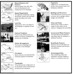
elements of the landscape into thirteen character-defining categories: natural systems
and features; spatial organization; land use; cultural traditions; cluster arrangements;
circulation; topography; vegetation; buildings and structures; views and vistas;
constructed water features; small-scale features and archaeological sites (Figure 2.4).
Category assignment identifies the primary use, presence and arrangement of site
features of the landscape under which associated individual features specific to the
primary use are grouped. For example, the landscape characteristic “vegetation” may
include a nested set of sub-features that describe specimen name, life-cycle and survival
specifications. The classification is meant to be flexible, applicable to features “ranging
from large-scale patterns and relationships to site details and materials” (Page, Gilbert
Figure 2.4 Thirteen landscape characteristics as illustrated by the NPS (source: Page, Gilbert and Dolan 1998: 53).
Similar to Lynch’s approach to understanding the relationship between
residential perception and location, this methodology highlights relationships between
features of historic or cultural value and their spatial location. A planner’s use of this
methodology allows a quantified, categorical and structured focus on a landscape’s past,
providing her or him with an intimate understanding of the evolutionary nature of
environmental change within the urban landscape (Lynch 1972: 238–239).
Although generally successful in application, the NPS approach was both too
narrow and too broad for effective use on the urban setting. Use of the NPS categories in
the field demonstrated that only three of the original categorizations (buildings and
structures, spatial organization, and cluster arrangements) were relevant and applicable
for urban historic resources. At the same time, the categories proved too limited to
27
capture the characteristics associated with a community’s understanding of space and
place. For this reason, the NPS’s approach was modified to include qualities associated
with character, image and place, with associated sub-classifications related to buildings,
people, activities, memories and events. These modifications transformed the
methodology from one designed to preserve the past for historical purposes into one that
emphasizes the collective urban character for present and future purposes, a concept
championed by Lynch and other theorists of the contemporary city.
The second concept, conditions of the cultural landscape, is similar to a
planner’s approach for evaluating the condition of the built and natural environment.
This methodology is used to evaluate the physical condition of historic and cultural
landscapes for the purposes of identifying “disturbances and deterioration” over time
(Page, Gilbert and Dolan 1998: 67, 68). This observational method is designed to gauge
detrimental activity over a prolonged period of observation and apply prescribed
solutions when appropriate. For example, the planner may survey a site and identify a
collection of historic buildings whose upkeep, purpose or modification is affecting the
cultural character of a neighborhood. The planner assigns a mixture of evaluations
ranging from good, fair, poor and unknown to document the conditions in text and
color-coded map format (Figure 2.5).15 The ultimate goal of this evaluative methodology is to
identify and evaluate the current condition of qualities that contribute to the historic and
cultural character of the site. Although Lynch and Rapoport acknowledge the
15
importance of identifying these character-contributing qualities, a methodology of this
type does not exist within present planning practice.
Figure 2.5 Survey form for evaluating the condition of the cultural landscape as illustrated by the NPS (source: Page, Gilbert and Dolan 1998: 68).
Use of this methodology is appropriate for urban areas; however, the scope of the
approach was modified to solely focus on features from the present built environment
that contribute to the cultural and aesthetic character of the site. The evaluative process
utilized the rating of good, fair, poor or unknown; however, their application was used to
determine the condition of physical features (architectural style, façade composition and
building use). The planner may use this modified methodology to map the strength and
condition of elemental pieces of a neighborhood’s character over time to protect and
strengthen it.
The final concept, historic significance, is designed to identify significant
associations related to a variety of historic features and episodes, including events,
29
people of importance, distinctive characteristics of design and unique landscapes (Page,
Gilbert and Dolan 1998: 71). Historic significance is “the meaning or value ascribed to a
structure, landscape, object, or site based on the National Register criteria for evaluation.
It normally stems from a combination of association and integrity” (Page, Gilbert and
Dolan 1998: 137). As originally designed, this methodology was intended to determine
whether a particular site should be designated on the National Register of Historic
Places (NR).16 Although NR designation is not directly relevant to this dissertation, the
mechanism for determining significance yields interesting results when applied to urban
historic landscapes. The methodology requires that an applicant satisfy at least one
criterion of four; applicants satisfying more than one criterion have a stronger case for
designation. The four criteria are defined as: “1) associated with events that have made a
significant contribution to the broad patterns of our history; 2) associated with the lives
of persons significant in our past; 3) embody the distinctive characteristics of a type,
period, or method of construction, or that represent the work of a master, or that possess
high artistic values, or that represent a significant and distinguishable entity whose
components may lack individual distinction and 4) have yielded, or may be likely to
yield, information important in prehistory or history” (Page, Gilbert and Dolan 1998:
71). This methodology is useful for determining the level of significance that a building
or monument has on a local, regional or national scale, but its associational strength has
no other purpose than determining NR designation.
16
30
A modified version of the NPS’s historical significance methodology provides
the planner with a unique approach that not only determines the strength of historically
significant buildings (on many scales), but also provides a practical mechanism for
design by allowing the planner to determine the true historic and cultural value of
historic buildings. For example, buildings determined to have low historic value might
be likely candidates for development. Similarly, the methodology enhances the
decision-making process by creating talking points for community involvement. Use of the
methodology allows residents to work with planners to determine, review and customize
the data, resulting in a true collaborative interpretation of what makes an area
significant. The modified methodology utilizes the classifications and definitions created
by the NPS as they adequately categorize qualities associated with culture, history,
meaning and aesthetic. The difference lies in the determination of significance. As with
the NR designation, the modified methodology calculates the number of satisfied criteria
on a building-by-building basis to determine strength. This modified methodology
provides planners with the ability to understand the strengths and weaknesses of
historical significant phenomena on a macro- and microscale. Such an experience can
positively influence the site planning process by conveying a vivid and meaningful sense
of place to both the planner and the community through communication and design
(Cullen 1996: 194, 195; Lynch 1960: 119; Lynch & Hack 1984: 5; Rapoport 1977: 26;
Relph 1976: 1, 146).
31
Both the APA and the ICMA recommend that planners consider the use of various kinds
of historic resources in practice. Both organizations have created policies regulating use,
standards guiding use and examples demonstrating application.
In 1987 (last updated and ratified in 1997), the APA produced a policy titled
“...Guide on Historic and Cultural Resources,” which explains that “the scope of historic
preservation practice has broadened to protect a greater array of cultural resources
including historic districts, buildings, structures, sites, public works, transportation
corridors, archaeological sites, heritage areas and corridors, cultural landscapes, objects
and related built forms. Planners conduct these activities as part of a comprehensive
planning framework that combines the benefits of preservation with other community
planning objectives” (APA Website 2009).17 In addition, the policy states that
“[p]lanning and preservation work hand-in-hand to ensure the conservation of housing
stock in residential neighborhoods, economic development and revitalization (including
the preservation and revitalization of downtowns), protection of historic landscapes, and
preservation and growth management of rural villages, and conservation of farmland”
(APA Website on Policy Guides 2009).18
The policy describes various threats to urban and rural historic resources and
proposes “a full integration of preservation and planning practice,” stating that “planners
must assume a greater responsibility to use the range of preservation techniques and
options” to prevent further loss of America’s historic resources (APA Website 2009).19
The policy sets out fourteen principles for practice, many of which focus on funding and
17
http://www.planning.org/policy/guides/pdf/historicandcultural.pdf
18
ibid.
19
32
legislation. Of the fourteen principles, one stands out as most relevant to this
dissertation. Principle eleven states “[the] APA and its chapters recognize that
neighborhoods are dynamic objects that evolve rather than remain fixed in time;
therefore, they support preservation strategies that respect the heritage, context, design
and scale of older neighborhoods while recognizing the evolution of those
neighborhoods’ built form” (APA Website 2009).20 The importance of this principle lies
in its acknowledgement of the past as a resource for understanding the context and
character of the setting—one of the fundamental themes of this dissertation.
It is unfortunate that the APA has not updated this policy to reflect current trends
of theory, practice or analysis. Although well intentioned, the policy appears as either an
afterthought or as a formality, whose relevance to the profession has yet to be proven.
The policy primarily relies on legislation and policy to affect change. Although effective
as a catalyst for change (as demonstrated in practice by preservationists and the NPS),
this legalistic approach to application tends to restrict and distract the planner from the
site-planning process. The use of these methodologies may result in the creation and
protection of a district or a neighborhood whose character is distinct, but these actions
simply place a glass dome over a section of a city, potentially frustrating both the
planner and the community, rather than reflecting the potential of historic resources to
improve the lived experience of a city.
In 2007, the APA produced Planning and Urban Design Standards (Student
Edition) to “provide reference to the standards met by the profession and present the
standards all should work to achieve” (Lewis and Klein in Steiner & Butler 2007: viii).
20
33
The book guides planners and planning students through the various areas of practice.
Many sections in the book acknowledge the importance of historic and cultural
resources in planning practice and suggest their incorporation either through additional
research or by using typical preservation planning strategies. In general, the book relies
on a combination of preservation planning strategies (legislation and policy) and
common-sense design to incorporate features from the past into planning. However, the
book fails in a few sections by either briefly mentioning its use (without providing
details or guidance for use) or by completely omitting its use from areas where they
obviously belong. For example, the section on comprehensive planning categorizes the
use of historic preservation for downtown and neighborhood revitalization initiatives,
but excludes it from any other part of the comprehensive planning process (Steiner &
Butler 2007: 8, 9 & 12). Similarly, the section on housing plans briefly mentions
preservation and its role for downtown and neighborhood revitalization, but provides no
guidance beyond the use of preservation planning strategies (Steiner & Butler 2007: 24).
The section on building types advises the planner to “be sensitive to….regional
styles and traditions” through observation, while also suggesting the use of zoning
regulations and design guidelines to address developmental “mass that is out of scale
with neighborhood or community character” (Steiner & Butler 2007: 121). Related to
these recommendations is the section on places and districts, which unfortunately omits
historic resources from its description of neighborhood composition (Steiner & Butler
2007: 227). While the sections on boundary identification and form guidelines provide