Public Space As Development Control Element In
Coastal Settlements: Comparison Of Urban
Design Guidelines Concepts
Nurhikmah Budi Hartanti, Achmad Hadi Prabowo, Arief Fadhilah, Dwi RosnartiAbstract: The objective of the study is to identify the appropriate typology of a public space design concept that effectively encourages the vitality of the area. The growth of coastal settlements requires special attention due to the dynamic characteristics of resources as well as the natural system. Coastal settlements in Indonesia experience problems of vitality. Public space has become a significant key element of many development schemes to solve the problem of vitality. It plays as a catalyst for urban renewal and arena for community participatory. It is a generator of urban vitality, which offers great social, economic as well as environmental benefits to the communities. The study was a comparative analysis of urban design guidelines in three different coastal settlements emphasizing on public space design policy. A qualitative assessment by the expert judgment was employed to assess the contribution of existing public space characteristics to the vitality of the area and the formulation of public space design concept in the urban design guidelines. The result shows that as a development control, public space can function as a balancer of activities, as a generator of activities, as well as reducer and distributor of activities.
Index Terms: coastal settlement, design concepts, development control, public space, urban design guidelines, element
————————————————————
1
I
NTRODUCTIONThe coastal area has been an attractive place for settlements since the beginning of human civilization because of the availability of resources, the defense advantages, and ease of access especially for trading activities [1], [2]. However, the growth of coastal settlements requires special attention due to the dynamic characteristic of the resources as well as the natural system. Human habitation in the coastal area has a considerable challenge in facing the dynamic and even hazardous nature. Coastal hazard can occur in a quick hit but cause fatal damages, or slowly develops over a while like tidal flood and sea erosion or abrasion [1],[3]. To the other hand, the growth of coastal settlement also threatens the quality of the coastal environment. The concentration of population in a coastal area can be a burden to the aquatic systems. Economic activities often followed by uncontrolled growth. The lack of infrastructure availability in a high-intensity development such as clean water provision and sanitation system is the main cause of the environmental problem of coastal settlement [4],[5]. Therefore, the need for development control instrument for the coastal settlement is a priority. There are various development control instruments in Indonesia, one of which is Rencana Tata Bangunan dan Lingkungan (RTBL) or urban design guidelines (UDGL), which cover the arrangement of the 3-dimensional physical form of buildings and urban space. The UDGL elements include: land uses structure and intensity, building arrangement, circulation and linkage system, open space and green systems, signage and
visual quality, and infrastructure systems. This paper focuses on the open space systems, especially public open space since it plays an important role as a development control element in the coastal settlement. Coastal settlement characteristic that is often a problem is the privatization of the waterfront area, which should be a common space accessible for all people [6],[7]. Coastal areas are used for various activities and social interactions so that the functioning of a space order will be determined by its components, which are also the manifestations of community's activity.
Public space has a more active meaning than open space. Its definition encompasses all spaces, in a built or natural environment, where people of all status can access it freely to carry out shared activities [8],[9]. The form of public space in the built environment range from merely spaces between buildings or street corners that incidentally used by public, up to formal squares where public life, activities, and events take place; whereas in the natural environment the scope is even broader including woods, beaches and waterfronts [10], [11], [12]. Public space has become a significant and pervasive tool of urban development policy, as a catalyst for urban renewal and arena for community participatory. It is a key element of many development schemes, a generator of urban vitality, which offer great social, economic as well as environmental benefits to the communities [13],[14],[15]. Urban vitality is not a new concept and widely applied in many policy documents of urban design and planning. The definition of vitality in this paper refers to the term described by Montgomery back to 1998 [16] to address a quality of urban space that socially successful. Vitality means the existence of people and activities in urban spaces. It refers to the variety of activities and the number of people involved in an urban space. Vitality is an important quality of a public realm that indicates economic viability, social interaction and reduces crimes, so the more human presence in urban space will make it more pleasant [12],[17]. Vitality is commonly employed as a consideration of public space quality. It is a criterion used in guiding urban design and development to ensure urban competitiveness, and many works emphasize the importance of public space in enhancing urban vitality [10], [12],[17]. Vitality concerned with four features, i.e.: levels of activity variety; levels of public participation; levels of interaction, ————————————————
Nurhikmah Budi Hartanti, is currently a lecturer of urban studies in undergraduate and master program, Architecture Department, Universitas Trisakti, Indonesia, PH +6281519977167. Corresponding Author E-mail: [email protected]
Achmad Hadi Prabowo, is currently a lecturer of urban design in undergraduate and master program, Architecture Department, Universitas Trisakti, Indonesia, PH +628121804562. E-mail: [email protected]
Arief Fadilla, is currently a lecturer of architectural design in the undergraduate program, Architecture Department, Universitas Trisakti, Indonesia, PH +6285265361225. E-mail: [email protected]. Dwi Rosnarti, is currently a lecturer of housing and settlement in the
3418 communication and transaction; and level of representation,
that is how all that features make the place unique and well known [17]. Regarding that, the parameter of vitality can be grouped four categories: (1) diversity; (2) density; (3) livability; and (4) accessibility [18], [19]. The concept has been broadly employed in the urban design guidelines of coastal settlements in several regions in Indonesia with different characters and problems related to the use of public space, especially those that experiencing a decrease in vitality [13],[14],[15]. This paper discusses the spatial planning concept of coastal settlements in Indonesia with a focus on public spaces design as a development control element, by comparing three coastal settlements with different characteristics and problems in Sulawesi and Kalimantan. The aim is to identify the typology of the public space design concept that is appropriate for the existing characteristics and effectively encourages the vitality of the area.
2
R
ESEARCHM
ETHODOLOGY2.1 Method
The approach applied in this study is mixed-method, which involves collecting, integrating, and analyzing both quantitative and qualitative data, to obtain a better understanding of a research problem [20]. The method was a documents review with the subjects was Urban Design Guideline (UDGL) documents of three different locations that compiled as a guide for area development. UDGL documents are prepared with standard procedures and substances that regulated in Ministerial Regulation number PU No. 06 / PRT / M / 2007 regarding "Urban Design Guideline Preparation Direction" [21]. Thus, each document has the same content and comparable materials. This study compares the document material on the subject of (a) the description of the existing condition; (b) the description of potential and problems, and (c) the design concept of public space as a solution offered. The study was conducted in the following stages. The first stage was reviewing the existing condition of the area and assessing its contribution to vitality. This includes the components that are indicators of vitality according to Zeng [18], that is: land uses as indicator of diversity; building and traffic density as indicator of density; building functions and public space activities as indicators of livability; as well as traffic characteristic, pedestrian ways as accessibility indicators. Each component assessed its contribution to vitality through expert judgment. In this case, the qualitative approach allows the researcher as an assessment instrument. The second stage was analysis of the relationship between the vitality contribution with the concept of spatial structure and public space design, based on contribution score of each component to the vitality and the components of the design concept. The third stage is to classify the spatial design and public space concepts into a typology, based on the level of contribution of each component, as well as identifying design factors that must be considered.
2.2 Research Cases and Design Area
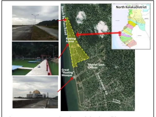
Urban Design Guideline of Palu Bay Tourism Area, Palu City, Central Sulawesi Palu is the capital city of Central Sulawesi Province with a population of 350.000. The city is called as a five-dimensional city because its geography consists of valleys, oceans, rivers, mountains, and bays. The study area, as shown in Figure 1, is located at the corner of Palu Bay and
is a recreational area known as Talise Beach. The design site is a combination of in the form of open land, which was an old unproductive salting field, and some commercial buildings. The main problems in this area are the un-optimal recreational activities with un-organized street vendors and the growth of commercial buildings in the tsunami-prone areas. For the record, the design guideline was prepared in 2014, four years before the tsunami struck on September 2018.
Urban Design Guideline of Lasusua City Square, North Kolaka Regency, South East Sulawesi
Lasusua is a small capital town of North Kolaka district, located at the edge of Bone Bay, with a population less than 50.000. Figure 2 shows that the design area is mostly vacant site of reclaimed land, and rowing sports natural pool. Between the site and the coast, there is a highway that connects Lasusua with Tobaku town. The main problem of the study area is the need to develop vacant land as a public space to increase the vitality of the city.
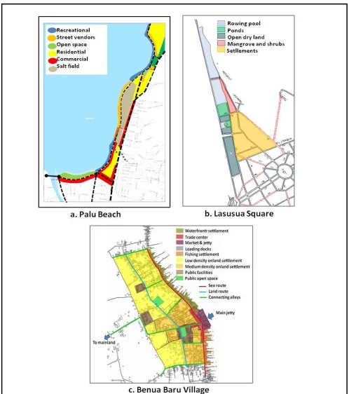
Urban Design Guideline of Benua Baru Village, Sangkulirang, East Kutai Regency, East Kalimantan
Benua Baru village is a capital town of Sangkulirang district, East Kutai Regency, in East Kalimantan province. It is located in a small island at Sangkulirang Bay on the northern coast of East Kalimantan. The design site is the city center of Benua
Fig. 1. Palu bay location and visual condition
Baru village, which is a small populated area, at the southeast part of the Island. The study area is about 90 hectare or only 2,3 % of the entire island (see figure 3.), with a population of less than 10.000. However, this village serves as the activity center for all Sangkulirang sub-district (kecamatan), as well as other areas around it within a radius of more than 10 kilometers. The main problem of the design area is the blocking of waterfront area by the fishermen settlements that grow along the shoreline, so the public access to the water is somehow restricted. As a result, public activities are concentrated around the great market and occupy the narrow road spaces.
3
R
ESULTS ANDD
ISCUSSIONThis paper focuses on the role of public space on regional vitality, so the discussion covers physical, social and functional aspects. The data used includes the existing conditions, the vision of development, the concept of spatial structure and public space.
3.1 Existing Character of the Study Area
Land Use Character
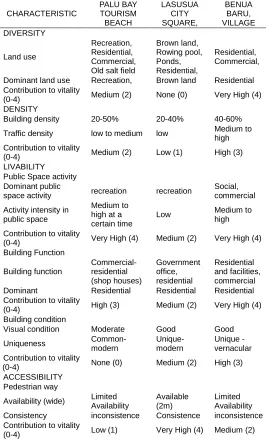
Land use will determine the characteristics of activities that shape the vitality of the area [17]. Land use in the three study locations is quite diverse, as well as the characteristics of vitality and problems that arise (Figure 4.). Land use in Palu Bay consists of open space, salting field, and a mix of residential and commercial. Tourism activities attract the street vendors, sporadically occupying the open space from afternoon until midnight. During the day, the beach is quite empty because of the hot atmosphere. This needs to be anticipated in order not to become more un-organized and slummy. Therefore, it is necessary to restructure the beach by creating an organized and visually attractive non-permanent commercial site. Meanwhile, as a newly reclaimed area, land use in Lasusua Square is mostly vacant wetland area. The active sites are a rowing sports pool and a few scattered housing, the other are ponds and open land covered by shrubs. With the potential of beautiful coastal scenery, the area will be developed as a public space to attract tourism activities and social interaction. On the contrary, Benua Baru coast is a densely populated area with fishing settlements block up almost along the coastline. The process of land use
development in Benua Baru is primarily determined by forces of attraction, which is the market, circulation routes and driven by economic motivation.
Circulation and accessibility character: Street network, Traffic, Parking, and Pedestrian Ways
The ease of circulation and accessibility will determine the vitality of the area [16],[17]. As shown in Figure 4, Palu Bay recreation area is relatively easy to access, because there are arterial and collector roads pass through it. The absence of a parking lot has not a problem since the traffic tends to be infrequent during the day, and the light crowds at night are still manageable with on-street parking system. However, this area is not pedestrian-friendly because there are no special lanes nor supporting activities for pedestrians. Located in a new un-built reclaimed site, Lasusua Square does not yet have adequate road network within the area, but is accessible through arterial roads from the southern end of the area, and soon there will be two new access point from the center and northern end. This is a very good potential for the area to draw visitors, as long as it provides good accessibility and facility, especially for pedestrians. Benua Baru village has a steady and hierarchical street network. Historically, there are three main street lines in Benua Baru Village. Two parallel lanes, called the sea-lane and the land-lane, heading north-south connecting the upstream to downstream area. Another lane is heading east-west from the market to the small jetty at the west side of the island that links to the mainland. All of those lanes classified as local streets. Parking problems occurred around the market during peak days or market days. Although it has not become a massive problem, it will make a heedless parking culture that will eventually undermine the urban spatial order. As a small town, most facilities are at a walkable distance, but there is no pedestrian path along the street except in the fishing settlements as a means to get to the dock.
Fig. 3. Benua Baru Village location and visual condition
3420 Building Form and Functional Characteristic
The shape and mass of existing buildings create grains and visual character of the area as well as open spaces between them. Building function provides the types of activities that will support vitality [15]. The building condition around Palu Bay recreation area is generally well-maintained, but there is no special character that can be a feature or identity. Likewise, the building functions do not have mutual support with recreational activities. Whereas in Lasusua Square, there is no permanent building inside the area, but there are relatively new and well-designed government's buildings, especially the iconic waterfront mosque. Although all those buildings are located outside the area, they can be a landmark leads to the design area. Among the three cases, Benua Baru has quite different building characters. The buildings function are mostly residential or mixed with commercial. The buildings form are quite specific, represent a typology of local vernacular architecture in timber structure and raised floor as an adaptation to the swampy land and to anticipate sea tides. Buildings lined up along the street and coast, facing the street with zero building lines. When the front line is full, new buildings grow toward the water on timber docks structure. Consequently, public access to water is closed and the waterfronts become uncontrolled private space.
Public Space Activity
Public space activities indicate the vitality of the area, it refers to the variety of activities and numbers of people involved in urban space [14]. In Palu bay recreation area, public activities mostly start from afternoon to evening, especially on weekends and holidays night. The form of activities is more of passive engagement enjoying the atmosphere and view of the beach, which is then supported by food and drink stalls. In Lasusua, rowing sports can be a generator of public activities on a wider scale, in addition to the potential of an attractive beach view. Whereas public activities in Benua Baru occur at the soccer field, mosque yard, and open spaces around the market. Residents also use fishing piers that are usually found among fisherman's houses, as places of interaction. It shows that waterfront remains as preferred public space, though the accesses closed by private houses. It is a critical situation because when a public space is privatized it ceases the public realm [9].
3.2 Contribution of the Existing Characteristics to the Vitality
The existing character of the area is a potential that can contribute to the urban vitality. Tabel 1 is a summary of the extent to which these characteristics contribute to vitality. The characteristic considered as the parameter of vitality, according to Zeng [18] are categorized: (1) diversity, which refers to variation of land uses; (2) density, which is characterized by building and traffic density; (3) livability, which is reflected by building function, condition and public space activities; and (4) accessibility, which is measured by availability of circulation facilities for both vehicles and pedestrians [18], [19]. Using an expert judgment, the level of contributions classified into four levels, which are: (0) None, means no contribution or influence to vitality at all; (1) Low, means very limited contribution or influence to vitality; (2) Medium, means there is a small contribution or influence to vitality; (3) High, means there is a significant contribution to vitality; and (4) Very high, means there is very significant
contribution or influence to vitality. Table 1. shows the components of existing characteristics and their contribution to vitality.
Diversity
Land use in Palu Bay Area only has a mediocre contribution to the urban vitality, because the recreational activities are limited and passive, and there is no direct interaction between the existing commercial activities and recreational activities. However, it is better than land use in the area of Lasusua City Square, which is dominated by vacant land, so it does not support vitality at all. On the contrary, land use in Benua Baru Village has a very significant contribution to its vitality, especially commercial activities that are concentrated in the grand market and its surroundings. This vitality even attracts visitors from outside the island. From these conditions, it can be said that commercial land use has the potential to contribute to vitality.
TABLE 1
EXISTING CHARACTERISTIC AND CONTRIBUTION TO VITALITY
CHARACTERISTIC
PALU BAY TOURISM BEACH
LASUSUA CITY SQUARE,
BENUA BARU, VILLAGE DIVERSITY
Land use
Recreation, Residential, Commercial, Old salt field
Brown land, Rowing pool, Ponds, Residential,
Residential, Commercial,
Dominant land use Recreation, Brown land Residential Contribution to vitality
(0-4) Medium (2) None (0) Very High (4) DENSITY
Building density 20-50% 20-40% 40-60%
Traffic density low to medium low Medium to high Contribution to vitality
(0-4) Medium (2) Low (1) High (3)
LIVABILITY Public Space activity Dominant public
space activity recreation recreation
Social, commercial
Activity intensity in public space
Medium to high at a certain time
Low Medium to
high
Contribution to vitality
(0-4) Very High (4) Medium (2) Very High (4) Building Function
Building function
Commercial- residential (shop houses)
Government office, residential
Residential and facilities, commercial Dominant Residential Residential Residential Contribution to vitality
(0-4) High (3) Medium (2) Very High (4) Building condition
Visual condition Moderate Good Good
Uniqueness
Common-modern
Unique-modern
Unique -vernacular Contribution to vitality
(0-4) None (0) Medium (2) High (3)
ACCESSIBILITY Pedestrian way
Availability (wide) Limited Availability
Available (2m)
Limited Availability Consistency inconsistence Consistence inconsistence Contribution to vitality
Walkability to the
urban center walkable walkable
Very walkable Public transport
availability
Limited
availability Not available Not available Contribution to vitality Low (1) Low (1) Very High (4) Traffic characteristic
Road function
Arterial, Collector, Local
Collector, Local
Collector, Local
Parking On
-street- On-street On-street Contribution to vitality
(0-4) High (3) Medium (2) High (3) Source: Observation and Expert Judgment
Contribution to vitality:
0- None: No contribution or influence to vitality at all 1-Low: Very Limited contribution or influence to the vitality 2-Medium: Small contribution or influence to the vitality 3-High: Significant contribution or influence to the vitality 4-Very high: Very significant contribution or influence to the vitality
Density
Building density in Palu Bay area is an average of 20-50%, with uneven distribution of buildings. Buildings are more concentrated in the southeast part of the area, due to the regulation of a 100-meter beach borderline, while the traffic density is between low during the day to medium in the afternoon. That condition gives a moderate contribution to the vitality. In Lasusua, building density is an average of 20-40%, but actually, it refers to the government buildings outside the design area, and the traffic is even lower, so as its contribution to vitality. On the contrary, Benua Baru has a higher building density with a more even distribution of buildings. The specific characteristic of this area is that the building growth starts from the water edge and leads to the water. After the waterfront is full, then the buildings grow in the land area. The buildings density and distribution character, with a mix of residential and commercial functions, affects traffic density, especially around the market, and it contributes quite high to the vitality.
Livability
Livability characters are supported by building function, condition, and public space activities. Building function in Palu bay is dominated by residential and shop-houses with a common-modern style and moderate physical condition. The condition of a well-maintained building will contribute to visual quality. Meanwhile, the assessment of buildings in Lasusua is referring to buildings near to the area since there are no buildings inside. Lasusua City Square design area is part of the new city center development, with the initial construction of government office complexes and city mosques. Those buildings are well designed and have unique characters that can become landmarks of the city and support the vitality of the area. Quite different characters are found in Benua Baru village, where most of the buildings are residential houses with very strong local characters. Besides, there is a grand market, which functionally plays as the main generator of activity, as well as physically as the landmark of the village. These conditions show that commercial buildings and buildings with uniqueness contribute to greater vitality [18]. Nevertheless, the biggest contribution to urban vitality is from activities in the public space [12],[17]. Both in Palu Bay and Lasusua Square, the dominant public space activity is recreation, but the
intensity is quite different. Public activity in Lasusua is low on average, while in Palu Bay is medium during day time and increasing at afternoon. Recreation activities supported by culinary activities along the beach in the afternoon can arouse attraction and has a significant contribution to its vitality. In the meantime, activity in the public space of Benua Baru Village is concentrated at the grand market and its surroundings, as well as in the mosque's yard. The types of activities that make the biggest contribution to vitality are recreational and commercial.
Accessibility
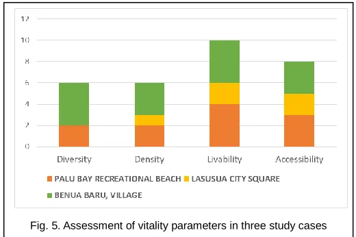
Public transportation and the pedestrian facility has a significant contribution to vitality [19]. In Palu bay, the component of accessibility that contributes to vitality in public space is the movement of vehicles, because accessibility in and around the area uses more vehicles than walking. The ease of vehicle circulation and availability of public transportation will attract people to visit. In contrast, the limited availability of pedestrian paths in this area makes walking accessibility is low. While in Lasusua, the accessibility is formed by the presence of pedestrian promenade along the coast, but not yet supported by street network and transportation. Its vitality is supported by the accessibility to the region through a well-planned area and interesting landmarks. Accessibility in Benua Baru Village has a very significant contribution to its vitality due to its walkability to activity centers, even though there are no pedestrian paths provided. Quantitative analysis of the contribution of vitality assessment shows that among the three study cases, Lasusua City Square has the lowest potential for vitality because the existing conditions do not support the vitality. It is shown in Figure 5, that the diversity parameters formed by land-use components in Lasusua is the lowest among the other locations, while Benua Baru Village has the highest potential of vitality, especially on the diversity and livability parameters.
3.3 Vision of Development and Concept of Spatial Structure and Public Space
Palu Bay Tourism Area, Central Sulawesi
The vision of developing the Palu Bay recreational Area is as inclusive beach tourism, educational tourism, and culinary center. The vision is based on the function that contributes most to vitality, which is recreation activities. The design concept is to increase the diversity of public activities and
3422 create a linkage system among those activities. Spatially,
public space consists of primary and secondary spaces connected by pedestrian paths. The concept of spatial structure is to create open spaces that serve as centers of activity (nodes). These open spaces are generators of public activities in the form of educational tourism activities, active recreation, and culinary centers. The nodes are connected with a linkage system in the form of pedestrian paths, vehicle lanes and parking lots to maintain continuity of space and activities.
Lasusua City Square, South East Sulawesi
Based on the existing potential, development vision of Lasusua City Square is as a water sports tourism, folks culinary center, hotels, and housings. Public space as a driving force of vitality is manifested in recreational activities, both active (sport) and passive. Public activities play as growth control by placing the right type and intensity of activities that fit the carrying capacity. Public space also serves as a linkage between existing commercial activities, settlements, and offices as well as development control by stimulating the development of the surrounding area. Since it was a new vacant area, it needs to create poles of activities that are interconnected with pedestrian paths to stimulate the growth of activities between these poles.
Benua Baru Village, East Kalimantan
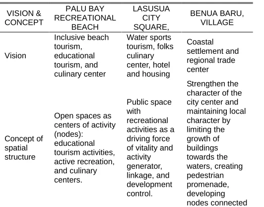
The development vision for Benua Baru Village is as a coastal settlement and regional trade center. The spatial structure concept is to strengthen the character of the city center and maintaining local character by limiting the growth of buildings towards the waters and creating a linkage system in the form of pedestrian paths. Existing activity centers, which are the market and the city square, are developed as the main nodes connected by a main street as a "great street". The waterfront area is reclaimed to its function as a public space by creating pedestrian promenades as a link as well as limiting the growth of fisherman settlement buildings. Table 2 shows the vision of development and the concept of spatial structure and public space in the three study cases.
TABLE 2
VISION OF DEVELOPMENT AND CONCEPT
VISION & CONCEPT PALU BAY RECREATIONAL BEACH LASUSUA CITY SQUARE, BENUA BARU, VILLAGE Vision Inclusive beach tourism, educational tourism, and culinary center Water sports tourism, folks culinary center, hotel and housing Coastal settlement and regional trade center Concept of spatial structure
Open spaces as centers of activity (nodes): educational tourism activities, active recreation, and culinary centers. Public space with recreational activities as a driving force of vitality and activity generator, linkage, and development control. Strengthen the character of the city center and maintaining local character by limiting the growth of buildings towards the waters, creating pedestrian promenade, developing nodes connected by a great street.
Concept of public space
As an activity center or vitality factor that connected by pedestrian paths to maintain the continuity of space and activities. As activity generator and Development control of the surrounding area
As city center connected by a great street and a pedestrian promenades as a growth barrier of waterfront settlement.
4
C
ONCLUSIONTo formulate the concept of public space as a development control should consider physical, social and functional aspects. Public spaces that have good urban vitality can become a generator and at once a controlling growth. To increase the vitality of the public space, a linkage system must be created between the centers of activity, especially activities that can support urban vitality. From the discussion of the three cases, there are three types of conditions and the concept of public space as a development control. First, public space as development controls with balancing function, which is balancing the existing activities that contribute to vitality. This concept can be applied in public spaces with low intensity existing activities. Second, public space as development controls with a generator function, which is generating activities in the public space and its surroundings. New activities are inserted into the existing public space evenly. This concept can be employed in areas with a lack of activities that contribute to vitality. Third, public space as development controls with the function of reducing and distributing the existing activities to locations with relatively low vitality. The concept is suitable for areas that already have a high vitality which needs to be controlled in order not to accumulate in one location and leading to over-vitality.
A
CKNOWLEDGMENTGreatest gratitude directed to Department of Architecture, Faculty of Civil Engineering and Planning, Universitas Trisakti for supporting this work; Directorate of Building and Environment Plan, Indonesian Ministry of Public Works and Housing as well as Government of East Kutai Regency for giving the opportunity to be involved in the process of preparing UDGL documents of Palu Bay, Lasusua Square and Benua Baru Village.
R
EFERENCES[1] G. McGranahan, D. Balk, and b. Anderson, "The Rising Tide: Assessing the Risks of Climate Change and Human Settlements in Low Elevation Coastal Zones", Environment and Urbanization, vol. 19, no. 1, pp. 17-37, 2007, https://doi.org/10.1177/0956247807076960
[2] C. Small and R.J. Nichols, "A Global Analysis of Human Settlement in Coastal Zones" Journal of Coastal Research, vol. 19, no. 3, 2003, p. 584-599, DOI: 10.2307/4299200.
[3] S. Huang, " Natural Disaster Reduction in Coastal Lowland Areas Natural Disaster Reduction in Coastal Lowland Areas", World Agro-Meteorological Information Service, available at http://www.wamis.org
/agm/pubs/agm10/agm10_14.pdf. 2019
[4] A. Rosytha, " Study on the Impact of Settlement Development in the Coastal Areas of East Surabaya" (Studi Dampak Pengembangan Permukiman di Wilayah Pesisir Surabaya Timur), AGREGAT, vol. 1, no. 1, November 2016, ISSN:
2541-0318,
[5] K. F. A. Lo and C. W. D. Gunasiri, "Impact of Coastal Land Use Change on Shoreline Dynamics in Yunlin County, Taiwan", Environments, vol. 1, 2014, DOI: 10.3390/environments1020124.
[6] I. Asmal, M. Ali, and S. Amin, "Coastal Environmental Degradation as Communal Space, Impact on Social Fishermen Community Life at North Galesong", IJIRES, vol.2, issue 5, 2015, pp. 428-434, available at http://www.ijires.org/index.php/issues?view=publication&ta sk=show&id=123, Jul 2019.
[7] M. Hafid, et.al, "Characteristics of Settlement at Balikpapan Coastal Road Area", Proc. of International Conference: Issues, Management and Engineering in the Sustainable Development on Delta Areas, Feb. 2015.
[8] M. Carmona, "Re-theorizing Contemporary Public Space: a New Narrative and New Normative", Journal of Urbanism, vol. 8,
no. 4, 2015, pp. 373-405,
http://dx.doi.org/10.1080/17549175.2014.909518.
[9] J. Nemeth, "Controlling the Commons: How Public is Public Space?", Urban Affairs Review, vol. 20, no. 10, 2012, pp. 1-25, DOI: 10.1177/1078087412446445, http://uar.sagepub.com. [10]M.N. Lopes and A.N. Camanho, "Public Green Space Use and
Consequences on Urban Vitality: An Assessment of European Cities", Soc. Indic. Res., 113, 2013, pp. 751-767, DOI: 10.1007/s11205-012-0106-9
[11]M. Carmona, "Principles for Public Space Design, Planning to Do Better", Urban Des. Int., vol. 24, 2019, pp. 47-59, https://doi.org/10.1057/s41289-018-0070-3
[12]S. Jalaladdini and D. Oktay, "Urban Public Spaces and Vitality: A Socio-Spatial Analysis in the Streets of Cypriot Towns", Proc. Social and Behavioral Sci., Dec. 2012, pp. 664-675, DOI:10.1016/j.sbpro.2012.02.135
[13]Directorate of Building and Environment Plan, Indonesian Ministry of Public Works and Housing, "Urban Design Guidelines of Lasusua City Square, North Kolaka Regency, Southeast Sulawesi Province, 2013", (unpublished).
[14]Directorate of Building and Environment Plan, Indonesian Ministry of Public Works and Housing, "Urban Design Guidelines of Palu Bay Tourism Area, East Palu District, Palu City, Central Sulawesi Province, 2014", (unpublished).
[15]Government of East Kutai Regency, East Kalimantan Province, "Urban Design Guidelines of Benua Baru Village, Sangkulirang District, East Kutai, 2017", (unpublished).
[16]J. Montgomery, "Making a City: Urbanity, Vitality and Urban Design", Journal of Urban Design, vol. 3, no. 1, 1998, p. 93-116. [17]N. Rastegara, M. Ahmadi, and M. Malek, "Factors Affecting the
Vitality of Streets in Johor Bahru City", Indian J. Sci. Res., vol. 7, no. 1, 2014, pp.361-374, available at
https://pdfs.semanticscholar.org/1c95/626c6925c87fd70256cf99 0f5b7640309ea8.pdf.
[18]C. Zeng, et.al., " Spatially Explicit Assessment on Urban Vitality: Case Studies in Chicago and Wuhan", Sustain. Cities and Soc., vol. 40, 2018, pp. 296–306, https://doi.org/ 10.1016/j.scs.2018.04.021
[19]A. Khalilin, S.N. Fallah, "Role of Social Indicators on Vitality Parameter to Enhance the Quality of Women's Communal Life within an Urban Public Space", Frontiers Arch.Res. vol. 7, 2018, pp. 440-454.
[20]Indonesian Ministry of Public Works and Housing, "Ministerial Regulation number PU No. 06 / PRT / M / 2007 on Urban Design Guideline Preparation Direction", 2007 (limited publication)
[21]J.W. Creswell, Research Design: Qualitative, Quantitative and