University of Pennsylvania
ScholarlyCommons
Publicly Accessible Penn Dissertations
Fall 10-11-2010
Landscapes of Achaemenid Paphlagonia
Peri Johnson
peri.johnson@gmail.com
Follow this and additional works at:http://repository.upenn.edu/edissertations Part of theClassical Archaeology and Art History Commons
This paper is posted at ScholarlyCommons.http://repository.upenn.edu/edissertations/273
For more information, please contactlibraryrepository@pobox.upenn.edu. Recommended Citation
Johnson, Peri, "Landscapes of Achaemenid Paphlagonia" (2010).Publicly Accessible Penn Dissertations. 273.
Landscapes of Achaemenid Paphlagonia
Abstract
This dissertation presents a critical study of the landscapes of Achaemenid-period Paphlagonia (c. 550-330 BCE), a mountainous region in northern central Turkey that extends from the verdant Black Sea coast to the sparser Anatolian plateau. In the classical literary sources and the imperial narratives of the Achaemenid Empire, the region of Paphlagonia has been characterized as a mountainous frontier, inhabited by migrants and ruled by gluttonous dynasts. Classically-informed historians writing about the Achaemenid period also speak of Paphlagonia as a bounded region, divided into several rival chiefdoms. Recent archaeological surveys and excavations in the region, however, present a different perspective: a complex and contested landscape politically and culturally related to the Black Sea and Anatolia, as well as the wider Aegean and Achaemenid worlds. A series of ubiquitous, columnar rockcut tombs spread across the Paphlagonian landscape function as significant monuments where such hybrid identities and political alignments are negotiated.
The dissertation develops a post-colonial critique of the ancient and modern discourses that reimagine Paphlagonia and Paphlagonians as marginal, uncivilized, and tribal. It traces the genealogy of how the region of Paphlagonia within classical geography came about in the work of 19th and 20th century colonial
antiquarians, geographers, and archaeologists; and demonstrates the modernist and nationalist underpinnings of their writings. Furthermore, the dissertation brings together data from recent archaeological surveys and excavations in the region to provide a fuller picture of the various landscapes of Paphlagonia, with special emphasis on the relationship of rockcut funerary monuments and settlement to copper mining, karst landscapes, and forest ecologies. Finally, the dissertation demonstrates a critical methodology of an
archaeology of landscapes by deconstructing ancient and modern discourses about them and creating a new analytical framework, using a combination of archaeological survey, archival research, and critical
perspectives.
Degree Type Dissertation
Degree Name
Doctor of Philosophy (PhD)
Graduate Group
Art & Archaeology of Mediterranean World
First Advisor C. Brian Rose
Second Advisor Holly Pittman
Third Advisor
Keywords
archaeology, Anatolia, Turkey, Achaemenid, Iron Age, chiefdoms
Subject Categories
LANDSCAPES OF ACHAEMENID PAPHLAGONIA
Peri A. Johnson
A DISSERTATION
in
Art and Archaeology of the Mediterranean World
Presented to the Faculties of the University of Pennsylvania
in
Partial Fulfillment of the Requirements for the
Degree of Doctor of Philosophy
2010
Supervisor of Dissertation
C. Brian Rose, James B. Pritchard Professor of Archaeology
Graduate Group Chairperson
Robert Ousterhout, Professor of the History of Art
Dissertation Committee
C. Brian Rose, James B. Pritchard Professor of Archaeology
Holly Pittman, Professor of the History of Art
David Gilman Romano, Senior Research Scientist of the Mediterranean Section
Landscapes of Achaemenid Paphlagonia
© 2010
ABSTRACT
LANDSCAPES OF ACHAEMENID PAPHLAGONIA
Peri A. Johnson
C. Brian Rose
This dissertation presents a critical study of the landscapes of Achaemenid-period
Paphlagonia (c. 550-330 BCE), a mountainous region in northern central Turkey that
extends from the verdant Black Sea coast to the sparser Anatolian plateau. In the
classical literary sources and the imperial narratives of the Achaemenid Empire, the
region of Paphlagonia has been characterized as a mountainous frontier, inhabited by
migrants and ruled by gluttonous dynasts. Classically-informed historians writing about
the Achaemenid period also speak of Paphlagonia as a bounded region, divided into
several rival chiefdoms. Recent archaeological surveys and excavations in the region,
however, present a different perspective: a complex and contested landscape politically
and culturally related to the Black Sea and Anatolia, as well as the wider Aegean and
Achaemenid worlds. A series of ubiquitous, columnar rockcut tombs spread across the
Paphlagonian landscape function as significant monuments where such hybrid identities
and political alignments are negotiated.
The dissertation develops a post-colonial critique of the ancient and modern discourses
that reimagine Paphlagonia and Paphlagonians as marginal, uncivilized, and tribal. It
traces the genealogy of how the region of Paphlagonia within classical geography came
archaeologists; and demonstrates the modernist and nationalist underpinnings of their
writings. Furthermore, the dissertation brings together data from recent archaeological
surveys and excavations in the region to provide a fuller picture of the various landscapes
of Paphlagonia, with special emphasis on the relationship of rockcut funerary monuments
and settlement to copper mining, karst landscapes, and forest ecologies. Finally, the
dissertation demonstrates a critical methodology of an archaeology of landscapes by
deconstructing ancient and modern discourses about them and creating a new analytical
framework, using a combination of archaeological survey, archival research, and critical
TABLE OF CONTENTS
I. CHAPTER 1: Introduction: Landscapes of Achaemenid Paphlagonia ...1
A. Mapping Paphlagonia in place and time ...1
i. Achaemenid Paphlagonia ...4
ii. Colonized Paphlagonia ...7
iii. Subjected Paphlagonia...12
B. Paphlagonian landscapes...15
C. Defining Paphlagonians ...18
i. Paphlagonians as the colonized ...18
ii. Paphlagonians as the imperial subject ...20
D. Paphlagonians with a material history ...22
E. Archaeological scholarship on Paphlagonia...23
F. Conclusion ...25
II. CHAPTER 2: Archaeological Landscapes: Physical and Social Frameworks ...26
A. Introduction...26
B. Geological landscape...27
i. Seismicity...27
ii. Aquifers ...29
iii. Mining ...33
C. Ecological landscape ...36
E. Connectivity ...45
F. Archaeological surveys...51
G. Columnar rockcut tombs...62
H. Settlement pattern ...64
I. Conclusion...73
III. CHAPTER 3: Colonization in Myth and Archaeology ...75
A. Colonial narratives: almost the same but not quite ...75
i. Mapping Homer – ofl PaflagÒnew...76
ii. Mythical reimagination of Sinope & other landscapes...83
iii. Athenian entanglements ...89
iv. Aristophanes – ı Paflag≈n...97
v. Xenophon – ≤ Paflagon¤a...100
B. Material narratives: the Sinop Promontory ...105
i. Settlement on Berezan Island ...108
ii. Sinopean residents: columnar grave markers and stelai ...110
iii. Sinopean leaders: numismatic and epigraphic evidence ...111
iv. Sinopean landscapes ...114
C. Material narratives: Samsun landscapes ...115
i. Achaemenid elites: tumuli ...115
ii. Fortified settlements ...118
D. Herakles in Paphlagonia...121
ii. Situated interpretations ...128
E. Conclusion...130
IV. CHAPTER 4: Chiefdoms within the Empire?...133
A. Introduction...133
B. Archaeological discourse on change and complexity ...135
i. Chiefdoms in archaeological discourse ...135
ii. Tradition and the traditional ...137
iii. Chiefdom as a heuristic concept...138
C. Achaemenid relations with Paphlagonia ...141
i. Achaemenid administration ...142
ii. Models of imperial administration...149
iii. Paphlagonia in the empire: evidence from imperial histories ...157
D. Discourses of difference...159
i. Thys – othering the Paphlagonian ...162
ii. Datames – the incorporation of Paphlagonia...168
iii. Behistun inscription...177
E. Discourses of similarity...180
F. Historical discourses...190
G. Conclusion ...193
V. CHAPTER 5: Multi-sited Archaeology and Kalekapı...195
B. Kalekapı...200
C. Kalekapı and Naqsh-i Rustam...207
D. Kalekapı and Persepolis ...211
E. Kalekapı and Göynüş Valley...222
F. Kalekapı and Kazankaya Canyon...238
G. Anatolian phreatic landscapes...243
H. Afırözü and Karaburun ...247
I. Conclusion...255
VI. CHAPTER 6: From Region to Landscape: Indigenous Tombs, Hirschfeld and the Making of Paphlagonia ...258
A. Introduction...258
i. Hirschfeld’s methodology and subjectivity ...262
ii. Imperialism: kaleidoscopic landscapes...267
iii. Colonial nationalism: migrating tribes ...269
iv. Hirschfeld’s invention...274
B. Hellenistic tombs...277
i. Kannenberg...277
ii. Terelikkayası...278
iii. Salarköy...281
iv. Asarkale and Kapıkaya ...283
C. The twentieth century...285
ii. Translating Leonhard: Gökoğlu...288
iii. Regional archaeology ...290
D. Conclusion: archaeological heterotopias ...292
VII. CHAPTER 7: Conclusion: Placing Paphlagonia...295
A. Discursive and social landscapes ...295
B. Regional settlement patterns ...298
C. Social and natural landscapes...299
D. The Black Sea coast ...300
E. The Achaemenid Empire’s Paphlagonia ...301
VIII. CATALOG: A selected inventory of archaeological sites...305
IX. BIBLIOGRAPHY...419
LIST OF FIGURES
Fig. 1. Map of Paphlagonia.
Fig. 2. Map of Homer’s Paphlagonia Fig. 3. Map of Herodotus’ Paphlagonia.
Fig. 4. Texier’s representation of the Paphlagonian king meeting the Amazon queen,
Yazılıkaya, Boğazköy (Texier 1839:pl. 78).
Fig. 5. Map of Xenophon’s Paphlagonia.
Fig. 6. Measured drawing of the reliefs and columnar porch of the Kalekapı rockcut tomb
(C.7).
Fig. 7. Map of the North Anatolian Fault Zone. Fig. 8. Ekinveren Fault Zone and İnaltı limestone.
Fig. 9. Map of sites associated with mining and copper ore deposits.
Fig. 10. Map of zones of inferred natural forest vegetation: deciduous in pale green,
montane in dark green, mixed woodlands in blue, and woodlands & anthropogene steppe in orange.
Fig. 11. Map of probable and possible routes in northern central Turkey in the
Achaemenid period.
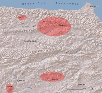
Fig. 12. Map of the distribution of tombs and tumuli discussed in catalog. Fig. 13. Map of the Iron Age settlement pattern.
Fig. 14. Maps of proposed Iron Age pathways at: a. Akalan (J.1), b. Tıngıroğlu Tepesi
(K.1), and c. Yüklütepe (C.6).
Fig. 15. Sinopean drachma dating from the last decade of the fifth century to the middle
of the fourth century. On the obverse is the head of the nymph Sinope facing left
and on the reverse are the eagle and dolphin in profile over SINO (Price 1993:pl.
53 no. 1439).
Fig. 16. Map of Sinop Promontory, Kızılırmak Delta, and valleys around Samsun. Fig. 17. Dugout building 41 dating to the middle of the sixth century, northwest sector,
Berezan (Solovyov 1999:62 fig. 46).
Fig. 18. House 4 built at the end of the sixth century, northwest sector, Berezan
(Solovyov 1999:74 fig. 53).
Fig. 19. Fluted Doric column burial marker of Bas, the son of Kallias, dating to the fifth
or fourth century. Height of marker: 0.64 m, Sinop Arkeoloji Müzesi inv. no. 13.48.70. (French 2004:pl. 4 no. 12)
Fig. 20. Sinopean drachma dating from the second quarter of the fourth century. On the
obverse is the head of the nymph Sinope facing left, and on the reverse are the
eagle and dolphin in profile over DATAMA (Price 1993:pl. 53 no. 1447).
Fig. 21. Silver amphora with ibex handles. Height: 0.29 m. (Amandry 1959:pl. 24) Fig. 22. Gilt silver phiale. Diameter: 0.19 m, Boston Museum of Fine Arts acc. no.
60.535. (Terrace 1963:pls. 29.3, 30.1.)
Fig. 23. Measured drawing of the reliefs within the gable of the Kalekapı rockcut tomb
(C.7).
Fig. 25. Central acroterion of the Alexander sarcophagus, royal necropolis, Sidon
(Graeve 1970:pl. 4.1).
Fig. 26. Corner acroterion of the Alexander sarcophagus, royal necropolis, Sidon (Graeve
1970:pl. 6.2).
Fig. 27. Elevation of the Alexander sarcophagus, royal necropolis, Sidon (Espouy
1981:pl. 98).
Fig. 28. Kalekapı as photographed from the SSW (C.7). Fig. 29. Map of the rockcut features of the Kalekapı site (C.7).
Fig. 30. Northeastern artificial trench and precipitous northwestern cliff of the eastern
section of the ridge at Kalekapı (C.7).
Fig. 31. Stepped wall footing that climbs to near the opening of a tunnel on the top of the
western outcrop of Kalekapı (C.7).
Fig. 32. The sequence of carving Kalekapı rockcut tomb.
Fig. 33. Map of the Persepolis environs (Schmidt 1970:7 fig. 1). Fig. 34. Persepolis environs (GE 10 April 2008, scale 2 km).
Fig. 35. Tomb of Darius I, Naqsh-I Rustam (Schmidt 1970:frontispiece).
Fig. 36. Royal hero in combat with lion griffin, south jam of the northern doorway in the
columned hall’s east wall, Persepolis (Schmidt 1953:pl. 116a).
Fig. 37. Center of eastern stairway of Apadana, Persepolis (Schmidt 1953:pl. 22).
Fig. 38. Lion and bull combat of southern section of central façade of eastern stairway of
Apadana, Persepolis (Schmidt 1953:pl. 20).
Fig. 39. Map of Göynüş Valley, Afyon (Based on Berndt-Ersöz 2006:317 fig. 5). Fig. 40. Aslantaş, Göynüş Valley, Afyon (Akurgal 1961:pl. 51).
Fig. 41. Maltaş ritual façade, Göynüş Valley, Afyon (Berndt-Ersöz 2006:338 fig. 33). Fig. 42. Yılantaş rockcut tomb, Göynüş Valley, Afyon.
Fig. 43. Drawings of the lion (a) and gorgoneion (b), Yılantaş rockcut tomb, Göynüş
Valley, Afyon (von Gall 1999:152 fig. 3, Akurgal 1965:fig. 6c).
Fig. 44. Map of the Kazankaya Canyon, Yozgat and Çorum Provinces (Duran and
Hamzaoğlu 2002:352 fig. 1).
Fig. 45. Sword god of the Underworld, Yazılıkaya. Height: 3.43 m. (Bittel et al. 1975:pl.
62.)
Fig. 46. Relief block with funerary banquet scene, Afırözü, Daday, Kastamonu (C.22).
Face: 27 × 43 cm, depth: 43 cm; Kastamonu Müzesi inv. no. 438. (Donceel-Voûte 1983:pl. 5 fig.4.)
Fig. 47. Paphlagonian rockcut tombs: a. Kargı Ambarkaya (I.17), b. İskilip tomb 4 (I.12,
Hirschfeld 1885:pls. 2, 4).
Fig. 48. Hirschfeld’s distribution of rockcut monuments in Asia Minor (1885:3).
Fig. 49. Paphlagonian rockcut tombs: a. Kargı Ambarkaya (I.17), b. İskilip tomb 4 (I.12;
Perrot and Chipiez 1892:200 fig. 139, 206 fig. 149; after Hirschfeld 1885:pls. 2, 4).
Fig. 50. Sketches of the Kızılırmak gorge and columnar rockcut tomb at Asarkale (J.14),
looking upstream: a. Prittwitz (1894:126), b. Flottwell (1895:pl. 4, detail).
Fig. 51. Terelikkayası columnar rockcut tomb (A.1): a. photograph of the outcrop (S.
Sabri), b. elevation and plan (von Gall 1966a:83-4 figs. 11a, 10).
Fig. 52. Terelikkayası columnar rockcut tomb (A.1): a. photograph of the tomb (S.
Fig. 53. Salarköy columnar rockcut tomb (A.9): a. photograph of the outcrop, b. elevation
(von Gall 1966a:57 fig. 3).
Fig. 54. Winged bull capital, Salarköy columnar rockcut tomb (A.9): a. frontal
photograph, b. oblique photograph.
Fig. 55. Gable of Evkayası columnar rockcut tomb 1 (C.18): a. photograph of the gable,
b. elevation (von Gall 1966a:67 fig. 7).
Fig. 56. Asarkale columnar rockcut tomb in fort cliff (J.14): a. photograph, b. elevation
and plan (von Gall 1966a:99 fig. 21).
Fig. 57. Asarkale columnar rockcut tomb in cliff upstream of fort (J.14): a. photograph,
b. elevation and plan (von Gall 1966a:97 fig. 20).
Fig. 58. Kapıkaya columnar rockcut tomb on the river bank facing the fort (J.14): a.
photograph, b. elevation and plan (von Gall 1966a:96 fig. 19).
Fig. 59. Tomb of Mithridates I, Amasya: a. photograph (Højte 2009:126 fig. 2), b.
elevation and plan (Fleischer 2009:112 fig. 4b).
Fig. 60. Durağan Ambarkaya columnar rockcut tomb (A.3): a. photograph, b. elevation
and plan (von Gall 1966a:105 fig. 25).
Fig. 61. Salarköy columnar rockcut tomb, plan (A.9, von Gall 1966a:58 fig. 4). Fig. 62. Slag heaps, Küre (B.8).
Fig. 63. Monolithic column plinth, Ağcıkişi, Taşköprü (C.5).
Fig. 64. Lion-griffin reliefs of the Kalekapı rockcut tomb (C.7): a. eastern, height 3.82 m,
b. western, height 3.52 m.
Fig. 65. Evkayası tombs 1 and 2 (C.18): a. photograph of tomb 1, b. plan of both tombs
(von Gall 1966a:65 fig. 6).
Fig. 66. Şehinşahkayası niche (C.20).
Fig. 67. Karakoyunlu columnar rockcut tomb (E.1): a. photograph, b. elevation and plan
(von Gall 1966a:74-6 figs. 8-9).
Fig. 68. Gümüştepe tumulus, Safranbolu (E.2).
Fig. 69. Tosya stele (F.9). Dimensions: 2.26 × 0.36 × 0.12 m, Çorum Müzesi inv. no.
20.1.81. (Durugönül 1994a:pl. 1)
Fig. 70. İskilip columnar rockcut tomb 1 (I.12): a. photograph, b. plan (von Gall
1966a:93 fig. 15).
Fig. 71. İskilip columnar rockcut tomb 4 (I.12): a. photograph, b. plan (von Gall
1966a:91 fig. 14).
Fig. 72. Kargı Ambarkaya columnar rockcut tomb (I.17): a. photograph, b. plan (von
PREFACE
The fieldwork for my dissertation began in 2002 with three months of travel in
northern central Turkey through a landscape of managed mountain forests separating
densely settled and intensively cultivated valleys and plains centered around cities and
towns. I traveled by public transportation, village tractors, and on foot to published first
millennium B.C.E. sites. This means of transportation imposed a slowness that allowed
me to become familiar with the people and their environment. The hospitality and
civility of the inhabitants assisted my travels throughout. Each day was spent at a single
site: Gavurevleri, Afırözü, Doğanlar Kayası, Akalan, Tıngıroğlu Tepesi, and many
others. I traveled in the Gökırmak Valley from Daday to Durağan, the Devrekani and
Eflani Plains, the Küre vicinity, the Araç and Soğanlı Valleys, the Devrez Valley from
Kurşunlu to Tosya, the Tatlıçay Valley and Çankırı, the İskilip Valley, the Kızılırmak
Valley from Osmancık to east of Kargı, the Çorum and and Alaca Plains, the Merzifon
Plain and Amasya Valley, and the coast from Samsun to Akliman. I aslo visited
Boğazkale to examine the Iron Age ceramics with Hermann Genz. Following my
research in the region of northern central Turkey, I traveled through the highlands of
Phrygia in Afyon and Eskişehir Provinces. My travels in 2002 inspired an interest in the
northern Turkey that has endured through the completion my dissertation.
During June of 2003 and 2004 Aslı Özdoğan of the Istanbul University Prehistory
Department and Catherine Marro, then of the French Institute for Anatolian Studies,
invited me to study the Late Iron Age ceramics collected by the Kastamonu Project
Laboratory. This analysis is not included in my dissertation but will appear in the final
publication of the survey. My participation in the Gordion Archaeological Survey in the
summer of 2001 proved invaluable background for my analysis of the Iron Age ceramics
of Kastamonu, particularly the ceramic fabrics. I also arranged a visit to Gordion in 2003
after the end of laboratory work in Istanbul to examine the Iron Age ceramics with Bob
Henrickson.
In 2004 the Ministry of Culture and Tourism granted me a permit to document the
columnar rockcut tomb at Kalekapı with single point photogrammetry. The fieldwork
was done with the photogrammetry specialist, Kemal Gülcen, of the Middle East
Technical University Photogrammetry Laboratory.
In 2006 I groundtruthed my measured drawing of the tomb and traveled to coastal and
mountainous areas in the northwest not visited in 2002: the coast from Bartın to Cide and
the Şenpazar vicinity. In 2008 I traveled in Azdavay and Pınarbaşı and visited Mızrak
Cave, the provenance of a Hittite sword. I also traveled in the north of Ankara Province.
During July and August of 2008 and 2009 I participated in the excavations and
surveys of the Pompeiopolis Project directed by Latife Summerer of the Institute for
Classical Archaeology, Ludwig-Maximilians University of Munich. The excavations
have uncovered only Roman levels, but my participation familiarized me with the
geomorphology of the Gökırmak Valley around Taşköprü. In 2009 I was the field
director of the survey component of the Pompeiopolis Project in Taşköprü County.
During the 2009 season we visited the Alaçam Valley, the Aşağıçay Valley, the Köçeklı
Plateau and Saraycık Mountain, and Samanlıören and the Karadere Valley.1
Many people have assisted me in fieldwork, analysis, and writing. First, I wish to
thank Murat Karasalihoğlu and Fulya Aldı for their generosity, hospitality, and
enthusiasm in sharing of their knowledge of Kastamonu. Next, I wish to recognize the
assistance of the residents of Afırözü, Karadonu, Eskiekin, Donalar, Samanlıören,
Kızılca, Kurmalar, Eymir, and the many other villages that I visited in the course of my
dissertation research. Without them my dissertation fieldwork would have been neither
so productive not pleasurable.
I deeply thank Aslı Özdoğan, Catherine Marro, and Latife Summerer for their
invitations to collaborate and lively discussions of the region.
Keith DeVries holds the credit for suggesting that I address the question of chiefdoms
in my dissertation. The influence of his seminars on Anatolian and Aegean archaeology
and history is present throughout this dissertation. Owen Doonan deserves thanks for
planting the seed of this dissertation by assigning a research paper on the region during
the Achaemenid period. David Romano not only taught me geographic information
science, but also generously provided space in the Corinth Computer Project Research
Laboratory where I rectified and digitized maps. His influence is visible in the
cartography included in the dissertation. Holly Pittman has always been constructively
critical and supportively concerned. Last but not least, I am deeply in debt to Brian Rose
for his thoughtful suggestions and thorough editing. No matter how thorough the editing,
CHAPTER 1:
Introduction: Landscapes of Achaemenid Paphlagonia
A. Mapping Paphlagonia in place and time
In classical literature Paphlagonia is a mountainous region that extends from the
verdant Pontic coast in the north to the arid Anatolian Plateau in the south (fig. 1).1
Rising from rugged foothills, the Pontic mountain range bends around the northward
bulge of Paphlagonia into the sea, with the Sinope Promontory and the delta of the Halys
River rupturing the curve of the coastline.2 A tributary of the Halys, the Amnias River,
flows eastward along the southern slopes of the Pontic mountains through a long and
broad valley. The southern bank of the Amnias is bound to the heart of Paphlagonia, the
evergreen forests of the Olgassys Massif. From the Halys in the east to the Billaios River
in the west, the massif straddles the width of Paphlagonia.
The string of valleys that tread along the zigzagging course of the Halys through the
mountains is the southeastern boundary of Paphlagonia. Through the southern
Paphlagonian plains, west of the Halys, two of its tributaries flow eastward past fortified
settlements at ancient Gangra and near contemporary Ilgaz. In the west, the rivers of
1 The following description draws upon the boundaries for Paphlagonia as presented in Strabo’s
Geographia (12.3) and as defined by Ruge and Bittel (1949:2489-94, especially their conclusion on
2493-4), Marek (1993:7-13), and Belke (1996:41-7). It also draws upon the ecological landscape as described by Belke (1996:48-54), Kuzucuoğlu and others (1997:275-81), and Marsh (in Matthews and Glatz 2009:29-47). In accordance with geographical convention, in this dissertation Anatolia refers to the peninsula extending from the Caucasus Mountains to the Aegean Sea. The citations by author and date of publication refer to works listed in the bibliography. The abbreviations in the bibliography follow the guidelines of the American Journal of Archaeology. References to ancient works follow the
abbreviations listed in the Oxford Classical Dictionary, 3rd ed.
Paphlagonia flow northwestward into the Parthenios and Billaios. The fort at Kimista on
a tributary of the Billaios lies near the western Paphlagonian border running through the
catchment of the river.3 The valleys of the Araç and Billaios Rivers are ample and open
around their confluence, although hemmed in by high mountains. Paphlagonia abounds
in many lesser rivers that flow through fertile mountain plateaus, but just as many rivers
cut through remote mountains with steep slopes and poor soils. The high mountain
passes of the Pontic mountains and Olgassys Massif similarly remove the valley of the
Amnias from both the coast and the valleys of the Halys tributaries south of Olgassys. In
a few words, Paphlagonia is a fragmented mountainous landscape. Consequently,
Paphlagonia is traversed by three separate itineraries: the nautically linked coast, the
Amnias valley linked to the west and east with lower mountain passes, and the valleys of
the Anatolian Plateau south of Olgassys.4
When writing archaeologies and historical geographies of Paphlagonia, the practice is
to begin with evocative descriptions of the ‘natural’ landscape similar to the preceding
paragraph. These descriptions are intended to paint the scenery for an archaeology or
historical geography of the region.5 The argument runs that the natural landscape
constrains the trajectory of Paphlagonian society, and, consequently, a description of the
natural landscape is properly introductory as background. The flip side of these
descriptions is that they give a misleading impression that Paphlagonia is ‘quite naturally’
3 Marek (1993:122-4) summarizes the arguments for the various suggested locations of Strabo’s Kimiata (12.3.41) and the emendation of Kimiata to Kimista, which Laflı recently surveyed near Eskipazar (2007, 2009, n.d.). See also Bosworth and Wheatley 1998:164.
4 Pathways, routes, and roads are discussed in the second chapter.
an internally coherent region. With respect to Paphlagonia, in particular, this impression
flies in the face of the literary and material discourses on Paphlagonia, as well as the
fragmented mountainous landscape itself. I argue in this dissertation that Paphlagonia as
a region is founded, primarily, on the scholarship of nationalism and associated concepts,
such as unchanging, bounded, and homogeneous ethnicities. I hold that Paphlagonia’s
construction in this tradition of scholarship required smoothing out inconsistencies in the
scant literary references from Homer through Byzantine scholars, and massaging stylistic
analyses of material culture to conform to this literary construct. Although the region
from the Billaios to the Halys, and from the promontory of Sinope to the Halys south of
Gangra were historically rarely integrated, archaeologists and ancient historians alike
consider this region as the extent of the distribution of ethnic Paphlagonians, and argue
that it is internally fragmented.6
We have now reached a stage where it is possible to demand more of our material and
literary sources, as well as ourselves. No longer is it acceptable to be engaged in a
disingenuous project of writing an archaeology of the past that fits into our preconceived
expectations of the past. It is possible for the difference of the past from the present to
emerge through a critical perspective and an analysis of the archaeological and historical
specificity of the area under study. This dissertation is an attempt to insert some
specificity of place and time back into the region of Paphlagonia during the Achaemenid
period. Paphlagonia as a place is concisely introduced in this section; Paphlagonia during
the period of the Achaemenid Empire in Paphlagonia is the focus of the following
section.
i. Achaemenid Paphlagonia
On the Anatolian peninsula, the first appearance of Achaemenid power was in c. 546
B.C.E. to the southeast of Paphlagonia, when the Achaemenid king Cyrus II responds to
an invasion of Cappadocia by the Lydian king Croesus.7 The army of Cyrus II engages
the Lydian army in battle at Pteria, a Cappadocian city provisionally identified with the
walled city on Kerkenes Dağı more than 100 km to the southeast of Paphlagonia.8 After
the defeat of Croesus, Paphlagonia and the rest of Lydian Kingdom are incorporated into
the Achaemenid Empire.9 The Achaemenid administrative organization of the Anatolian
peninsula does not emerge until the imperial reforms of Darius I in c. 519, when the
peninsula is reorganized into administrative regions or satrapies. After his reforms,
Paphlagonia becomes a dependency of Daskyleion, the residence of the satrap of
northwestern Anatolia. To the west of Paphlagonia is Mariandynia, another dependency
of Daskyleion, and to the south and east of the Paphlagonia’s Halys River border,
respectively, stretch the satrapies of Phrygia and Cappadocia.10
7 All unlabeled dates in this dissertation are B.C.E., unless clarity requires otherwise, and all C.E. dates are labeled. Additionally, the more specific term “Achaemenid Empire” is preferred to “Persian Empire.” Cyrus II is the founder of the Achaemenid Empire, and he is also known as Cyrus the Great. On the chronology of Cyrus II’s campaign, see Briant 2002:34-5. The capital of the Lydian Kingdom of Croesus is Sardis, a city near the Aegean coast of the Anatolian Peninsula.
8 Herodotus 1.76 (hereafter, Hdt.); G.D. Summers 1997, 2000; cf. Rollinger 2003a:305-19, 2003b; Tuplin 2004:232-48. Summers has proposed that Kerkenes Dağı is Pteria, but other fortified settlements have been proposed nearer to Paphlagonia, such as Eğrikale (see entry A.2 in the Catalog). Pteria is a Greek
place name meaning “wing-like” or “feather-like,” probably referring to the walls, and derived from tÚ pterÒn “feather.” Other fortified sites might be called Pteria, but of the possibilities, only Kerkenes Dağı is a walled Cappadocian city occupied in the sixth century.
9 On Paphlagonia’s inclusion in the Lydian Kingdom, see Hdt. 1.6, 28, 72.
Historical sources on the fifth century are silent about Paphlagonia except for a
reference in Herodotus’ census of Xerxes’ army assembled for the invasion of the Greece
in 480. Herodotus lists Paphlagonians under the command of Dotos, the son of
Megasidros.11 The sources on the fourth century, similarly, introduce Paphlagonians into
literary narratives only when the Paphlagonians emerge on the wider Anatolian and
Aegean stage. In these fourth century sources the place name “Paphlagonia” first
appears, and the derived name of the people “Paphlagonians” replaces Paphlagones,
which had been used earlier.
The first of the four episodes occurs during the retreat of Xenophon and the Greek
mercenaries in 401 through eastern Anatolia.12 When they are camped outside Kotyora,
c. 200 km east of the Halys River, the Sinopean representative (proxenos) of the
Paphlagonian ruler Korylas persuades Xenophon and the mercenaries to sail along the
Paphlagonian coast rather than marching through Paphlagonia. Herodotus mentions that
Korylas had not yet submitted to the Achaemenid king Artaxerxes II, even though he had
been summoned to do so. This recalcitrance of the Paphlagonian ruler is a literary trope
that connects the Korylas episode with the subsequent two episodes.
The second episode occurs in the west of Paphlagonia. During an expedition between
396 and 394 to decrease the influence of the satrap of western Anatolia and increase
Spartan influence, Agesilaos arranges a marriage alliance between an exile from
Daskyleion, Spithridates, and the Paphlagonian king Otys. The daughter of Spithridates
(Hdt. 3.90). Additionally, I argue Cappadocia and Phrygia are Anatolian Plateau satrapies neglected by Herodotus.
11 Paphlagonians are grouped with the Matieneans, a people from around Lake Urmia in northwestern Iran (Hdt. 7.72-3).
is promised to Otys to strengthen Agesilaos’ alliance with Otys, and Otys’ contribution of
3000 cavalry and foot soldiers to Agesilaos’ expedition.13 Xenophon describes Otys as
not having submitted to Artaxerxes II, and his alliance with Agesilaos is an additional
step in opposition to Achaemenid administration.
The third episode is the most significant for the history of Achaemenid Paphlagonia.
The episode centers on the activities of Datames, who was the son of an Achaemenid
governor in southern Anatolia and a Paphlagonian princess.14 In the 380s, Datames was
given the command of an expedition to capture his cousin, the Paphlagonian king Thys.
Later activities of Datames in Paphlagonia, such as Sinopean coins minted by him, are
frequently woven into narratives on instability in Achaemenid Anatolia in the 360s.15
With respect to the historical implications for Paphlagonia, however, the trope of the
recalcitrant Paphlagonian king serves as the justification for the more direct Achaemenid
administration of Paphlagonia and its coastal Greek cities by Datames following Thys’
capture in the 380s.
Paphlagonia’s more comprehensive participation within the Achaemenid Empire
becomes apparent in the fourth episode, when the son of the satrap residing at Daskyleion
and several other Achaemenids with Iranian names written in Aramaic script issue coins
in Sinope. All the coins date between c. 360 and c. 330, and possibly represent the period
of Achaemenid resistance to Alexander after the defeat at Issos.16 With the satrapal
13 Xen. Hell. 4.1.1-28; Briant 2002:634-45. In other versions of the episode Otys is referred to by different names. In Xenophon’s Agesilaus (3.4) and Plutarch (Vit. Ages. 11.1-4), Otys is referred to as Kotys,
and his name appears as Gyes in the Hellenica Oxyrhynchia (24.6-25.2 [Chambers 1993:47-8]).
14 Nepos Datames 1.1, 2.4 (hereafter, Nep.).
15 The coins minted at Sinope by Datames are dated to the 360s (C.M. Harrison 1982:181).
centers under Macedonian control, the Achaemenid elite of Anatolia retreat to a region
still under Achaemenid administration to increase the number of soldiers and mint coins.
At the close of the two centuries of Achaemenid presence in Anatolia, Paphlagonia
becomes more directly administered by Daskyleion.
My objectives in this dissertation are to develop a recursive relationship between this
historical argument for the process of imperial incorporation and the interpretation of the
archaeological evidence. Previously, the historical sources portraying recalcitrant and
rival Paphlagonian chiefs aligned well with the archaeological evidence for fortified
settlements dispersed in the physically fragmented, but supposedly ethnically
homogenous landscape. Problems began to emerge from both the historical and
archaeological evidence, particularly with respect to a Paphlagonian identity during the
Achaemenid period and the fourth century landscape. What was the archaeological
evidence for a Paphlagonian identity? If the chiefs were always recalcitrant and engaged
in rivalry, how could the landscape have developed? In order to address these problems,
this dissertation undertakes an analysis of how Paphlagonia is mapped in the colonial
Greek and imperial Achaemenid worlds. Through these analyses, the dissertation
develops a fresh understanding of the region situated in the archaeological landscape of
the impact of Achaemenid Empire in Anatolia. Several critical perspectives on the
scholarship of nationalism as well as colonialism and imperialism inform the theoretical
framework in which these analyses are undertaken.
ii. Colonized Paphlagonia
The first critical perspective on colonialism is reflected in my qualification of the
scholarship are peeled away, Paphlagonia loses integrity and becomes a restless place
that flits here and there around the map. In Homer’s Iliad, Paphlagonians live where the
Parthenios River debouches into the sea and to the northeast along a short stretch of the
coastline (fig. 2).17 Diverging from Homer’s more western oriented Paphlagonia,
Herodotus creates an eastern and more abstract Paphlagonia (fig. 3). In his description of
Anatolia as separated by the Halys River into the western lowlands and the eastern
highlands, Herodotus defines the Halys as the eastern border of the region where the
Paphlagonians live.18 These restless and variously placed Paphlagonias of Homer and
Herodotus are to be approached through a critical analysis of the authors’ discursive
imagination. Once the concepts of modern colonialism are peeled away, their
Paphlagonias remain ancient colonized places, both in a tangible sense, emerging from
the analysis of Greek settlement practices, and in a discursive sense, emerging from
Paphlagonia’s multiple mappings in the Greek imagination.
Homer’s use of Paphlagonia in the Iliad is particularly intriguing, in that he is
composing not only the founding epic of the Greek community but also an explanation of
Greek expansion into the Black Sea. Drawing on a memory of the Hittite kingdom of
Pala, Homer reimagines the place name as Paphlagonia.19 The Homeric name becomes
valuable and contested, but not bound to administrative borders, as names are bound in
17 Homer Il. 2.851-5 (hereafter, Hom.). The Parthenios River as mapped in figure 2 is the Kocaçay branch of the Bartın River.
modern colonial mapping.20 Paphlagonia also becomes entangled in Homer’s outward,
maritime perspective, wherein the familiar mapped coastal lowlands are reimagined
through translation into Greek, and the more unfamiliar inlands are nameless and
fantastic places of difference. Herodotus, on the other hand, presents the Paphlagonians
as one of the known coastal peoples but is silent about inland place names; there is a
vague reference to Paphlagonia as an area located inland along the Halys River. This
maritime perspective leads, therefore, to an ambivalent imagination of a Hellenized
coastal Paphlagonia, and a nameless inland Paphlagonia.
This glance at the earliest literary references to Paphlagonia is enough to demonstrate
that the concept of an unchanging, bounded region serves Paphlagonia rather poorly. It is
not just a question of poor fit, however. When the literary references are refracted
through the lens of modern orientalist and nationalist scholarship, it becomes clear that
such perspectives continue to filter how contemporary archaeology sees the past. The
first scholar to identify Paphlagonian monuments, French architect Charles Texier, is an
early and particularly transparent example.21 With the hazily mapped Paphlagonia of
Homer and Herodotus in mind,22 Texier in 1834 proposed that the Paphlagonian king met
the Amazon queen at the Hittite rockcut sanctuary at Yazılıkaya located east of the Halys
River near Boğazköy (fig. 4).23 He describes the rockcut imagery as follows:
20 Modern colonial mapping was a “concretization of…the colonial state’s peculiar imagining of history and power” (Anderson 1991:185).
21 Before Texier, The French consul at Sinop, Pascal Fourcade, had published an article about the Roman city of Pompeiopolis in Paphlagonia (Fourcade 1811).
22 Texier 1839:218-9.
The [Paphlagonian] king is armed with a club; he is bearded and wears a very tall conical hat. All his retinue, which is composed of figures similarly clothed, is set out as follows: a corps of soldiers; three generals; three princes; a retinue of gift bearers with each one preceded by a soldier; the navy represented by two men who carry a boat; a monarch who appears to be a vanquished king, dorophores, all dressed in long dresses and bearing on
their backs a kind of quiver or wings; finally, the king who holds in his hands a gift.24
Conflicting perspectives abound in Texier’s description of the Paphlagonians. The king
is a barbarian warrior armed with a club, yet his court is modeled on the French
government with monarch, military officers, and the nobility of the Paphlagonian
“nation.”25 This is despite describing the meeting as displaying “Asiatic pomp” and
brushing aside the similar belief of the villagers of Boğazköy that the reliefs were of the
Ottoman sultan and court.26
As an orientalist and a subject of the French king, Texier holds views that are not
surprising, but his unreflexive interpretation conflates contemporary prejudices on Asiatic
pomp with an aesthetic judgment on the primitive and barbarian quality of
Paphlagonians, their reliefs, and of their Ottoman descendants.27 The conflicting
accounts within Texier’s interpretation of Yazılıkaya are characteristic of colonial
24 “L’autre roi [Paphlagonien] est armé d’une massue; il est barbu et coiffé d’un bonnet conique très-élevé. Toute sa suite, qui se compose de figures également vêtues, est disposée ainsi: Un corps de soldats [Bittel et al. 1975:pl. 56 nos. 1-12 (underworld gods)], trois généraux [nos. 13-5 (mountain gods)], trois princes [nos. 16 (unidentified god), 16a & 17 (mountain gods)], une suite de dorophores précédés chacun d’un soldat [nos. 18-26 (unidentified gods), no. 27 the underworld god Nergal)]; la marine, représentée par deux hommes qui portent une barque [nos. 28-9 (the bull gods Hurri and Sheri holding a cresent moon]; un monarque qui paraît un roi vaincu [no. 30], des dorophores, tous vêtus de longues robes et portant sur le dos des sortes de carquois ou d’ailes [nos. 31-41]; enfin le roi qui tient dans ses mains le présent [no. 42]” (Texier 1839:219, my translation).
25 Texier’s original interpretation had the Paphlagonian king meeting the Persian king followed by “a warrior of the Persian nation” (ibid.:218-9, italics added). Texier emended his description to have the
Amazon queen meeting the Paphlagonian king, with the Leukosyrian king behind the queen (ibid.:219). 26 The villagers of Boğazköy (now Boğazkale) interpret the reliefs of Yazılıkaya as representations of their
Ottoman government (ibid.:214), just as Texier models his interpretation on the French government. It is well known among Hittitologists today that the scenes depict Hittite deities and royal ancestors accompanied by various other ritual scenes (Bryce 2002:195-9).
archaeology and illustrate some of the prejudices entangled in the modern constructs of
Paphlagonia. Even more significantly, the conflicts clarify that it is not a straightforward
question of “each age writing the history of the past anew with reference to the conditions
uppermost in its own time,” as the colonial historian of the American frontier stated.28
The question is how archaeology navigates between uncritical application and critical
analysis of contemporary preoccupations, both of which are “necessarily interventions in
political discourse.”29 When Texier discovers the oriental in antiquity, he is necessarily
participating in French colonial policy.30
Contemporary research on Paphlagonia has not always recognized the complicity
between political and archaeological discourse. The slippage from American political
discourse after the violence on September 11th, 2001 to Paphlagonian “landscapes of
terror and control” is inexplicable in research conducted in a majority Islamic country.31
The critical perspective towards colonialism in my dissertation is intended to assist me in
stepping over the pitfalls of research on a region that has a history of both ancient
colonialism and modern orientalism. To lead my archaeological interpretations on the
path to a self-reflexive discourse, I also take a critical perspective towards the
interpretations that reimagine Paphlagonia as imperial subject.
28 The quotation is from Turner’s essay on the significance of history ([1891]1938:52, italics added). 29 This is my paraphrase of Chatterjee’s insightful comment: “the critical analysis of nationalist thought is
also necessarily an intervention in a political discourse of our own time” (1999b:52). 30 This is the argument of Said against the passivity of scholarship (e.g. Said 1978:12).
iii. Subjected Paphlagonia
The Paphlagonias of Homer and Herodotus are subjected places tangentially
participating in epic and imperial struggles. For Herodotus, and later for Xenophon, the
struggle is against the Achaemenid Empire. Through imperial eyes, Xenophon, in
particular, sees Paphlagonia as coastal mountains and rivers to be traversed on his
westward return to the Aegean. Paphlagonia is entered through a mountain pass west of
Kotyora; the pass leads to plains where the Paphlagonian cavalry can operate; and the
Thermodon, Iris, Halys, and Parthenios Rivers follow (fig. 5).32 Notwithstanding the
sequence of the description, the plains of Paphlagonia are not east of the Thermodon
River; the sequence is entirely structured for rhetorical effect.33 Additionally, the
emphasis of Xenophon’s imperial perspective is primarily the military itineraries:
mountain passes, plains where cavalry have the advantage, river fords, and other loci
linked to military strategy.34
In the writings of a contemporary of Texier, the British antiquarian William
Ainsworth, Xenophon’s ancient imperial perspective becomes entangled in a modern
32 During the retreat of the mercenaries from Babylon in 401, Xenophon has the representative of the Paphlagonian king emphasize the difficulty of traversing the mountains and rivers of Paphlagonia (An.
5.6.6-10). The representative’s description is a sequence. The mountain pass is located close enough to the mercenaries’ camp that the representative can show it to them: “I would show it to you, if you were to send someone with me” (taËtad¢ka‹de¤jaimiên, e‡mo¤tinaboÊloisyejump°mcai, 5.6.7). The pass and the plains are followed by the rivers: “If you are able to win, by taking the mountains by stealth or anticipation…,you will come to the rivers” (ἢν δὲ καὶ δυνηθῆτε τά τε ὄρη κλέψαι ἢ φθάσαι λαβόντες…, ¥jete§p‹toÁwpotamoÊw, 5.6.9). Xenophon narrates another story about Paphlagonia in 395when the Spartan king Agesilaos was marauding through the satrapy of Pharnabazos (Hell. 4.1.18).
Agesilaos, the Paphlagonian king Otys, and the exile Spithridates arrange a military alliance at an unnamed place in Paphlagonia that is distant from the Black Sea and near Pharnabazos’ Phrygia. 33 The map (fig. 5) still stands because of Xenophon’s inclusion of the eastern rivers in Paphlagonia. 34 Xenophon’s status as a mercenary in an Achaemenid expedition does not necessitate that his perspective
imperial mapping.35 Ainsworth participated in several British expeditions exploring
routes through the Ottoman Empire as a surgeon and geologist, most notably the
Euphrates Expedition between 1835 and 1837, and an expedition to Mosul that traveled
through Paphlagonia in 1838. As the precedent for his explorations, Ainsworth embraces
Xenophon’s imperial perspective and endeavors to map Xenophon’s route.36 Ainsworth
identifies, for example, the mountain pass east of the confluence of the Gökırmak and
Kızılırmak as the mountain pass in Xenophon, “who said that Paphlagonia must of
necessity be entered by but one pass, and that lay between two points of a rock exceeding
high.”37 Ainsworth’s mapping of the places described by Xenophon onto the Ottoman
landscape reimagines the landscape within a western framework that claimed a Hellenic
legacy. Mapping and renaming places is not a passive scholarly endeavor.38
Ainsworth’s embrace of Xenophon not only doubly obscures Paphlagonia under a
general ancient and modern imperial cloud, but also serves to reflect attention away from
the differences between the imperial frames of reference of Xenophon and the nineteenth
century. Ainsworth’s dissimulation validates his explorations while masking his military
objectives.
Similar to Ainsworth’s mapping of Xenophon, my introductory description of the
Paphlagonian landscape maps Strabo’s names and boundaries for Paphlagonia (fig. 1).
Strabo wrote under Augustus, at which time the Greek descriptions of Paphlagonia had
35 Ainsworth 1844.
36 Ainsworth 1838, 1839, 1842, 1888.
37 Ainsworth (1839:256) referring to Xen. An. 5.6.7. Xenophon is probably referring to a mountain pass near Kotyora. Ainsworth juxtaposes the brigandage on the mountain pass under the Ottomans and Korylas’ hostile control of the pass (1839:256-7). This is the mountain pass that passes by Terelikkayası (see entry A.1 in the Catalog).
spanned half a millennium. Even so, Strabo describes three separate Paphlagonias: the
Pontic coast and Amnias Valley controlled by Mithridates Eupator, and the valleys south
of the Olgassys Massif controlled by dynasts.39 Strabo also mentions the prevalence of
Paphlagonian names in Cappadocian valleys along the Halys and describes the Kaukones
on the Pontic coast to the west of Paphlagonia as Paphlagonians.40
Strabo’s description cannot be mapped as a region with unchanging, bounded, and
homogeneous ethnicities. His landscape is a palimpsest composed of local knowledge
and literary and historical memories of the recently defeated Pontic Kingdom and the
preceding Achaemenid Empire. In contrast, the concept of homogeneous ethnicities lies
at the foundation of nineteenth century nationalism. European imperialism in the
Ottoman Empire coupled economic and military expansionist policies with the
assumption of the universal applicability of this nationalism.41 Consequently, it is only a
consensus that emerged among the antiquarian colonial travelers and subsequent
archaeologists that Paphlagonia “was enclosed between the river Parthenius and Halys on
the west and east, contiguous to Galatia on the south, and bordered by the Euxine on the
north.”42 This consensus formed through iteration and accretion of knowledge developed
in national and imperial frames of reference, without the necessary occasional revisions
and shedding of the prejudicial perspectives of earlier decades.
39 Strabo 12.3.9-11 (Pontic Paphlagonia); 12.3.9, 40 (Amnias Valley); 12.3.9, 41 west and south of the Olgassys Massif.
40 Strabo 12.3.25 (Paphlagonian names in Cappadocia), 8.3.17 (on Kaukones).
41 Massey 2005:64-5. See the sixth chapter for a discussion of nationalism within late nineteenth and early twentieth century German imperialism in the Ottoman Empire.
In response to the theoretical questions raised by mapping and renaming, my
dissertation uses contemporary place names, except where historically appropriate.
Additionally, the region analyzed extends beyond the Halys (Kızılırmak) and Parthenios
(Bartın) Rivers.43 As a concession to clarity and the historical situation during the
Achaemenid period, the name Paphlagonia refers approximately to the region between
the Kızılırmak and the Bartın Rivers.44 Although my dissertation does not propose a
methodology that addresses the intrinsic questions of mapping, my analyses of the
archaeological, literary, and historiographical evidence engage the extrinsic questions
raised by my critical perspectives towards the colonial and imperial frameworks.45
B. Paphlagonian landscapes
Most significantly, in order to construct a new framework for Paphlagonia during the
Achaemenid period, I adopt a distinctive landscape perspective. At the center of my
43 This extension is more comprehensive to the east of the Kızılırmak because of the research conducted in the coastal hills around Samsun, in the Havza and Vezirköprü Plains, and along the right bank of the Kızılırmak. The surveys conducted by Karauğuz to the west of the Bartın River have produced little evidence that dates before the Roman period (Karauğuz 2006, 2007, 2008, 2009).
44 The late Ottoman Kastamonu Vilayeti is coterminous with the region of Paphlagonia, with the exception of additional counties in the west (Bolu, Ereğli, etc.), but no contemporary region corresponds to Paphlagonia (Cuinet 1894:404). The region is approximate primarily because of hesitation about connectivity and settlement pattern on the left bank of the Kızılırmak southeast of Çankırı (I.1-15), in
the V-shaped area on the right bank of the river between Osmancık (I.16) and Kargı Ambarkaya (I.17),
and on the Kızılırmak Delta (J.7-14). It does not seem probable that an empire that attempted to
administer the coast and the subregions north and south of the Ilgaz Massif would not have included the nexus between Safranbolu (E.2) and Deresemail Asar Tepe (E.5) as part of Paphlagonia (catalog entries
in bold). Secondarily, the region is approximate because of the administrative contingency of Achaemenid Anatolia and Paphlagonia as a potential configuration of the landscape, as discussed in the fourth chapter.
perspective is a definition of landscape as “an anonymous sculptural form always already
fashioned by human agency, never completed, and constantly being added to.”46
Landscapes are dependent on what has come before and is happening in a specific place.
This definition brings the associated questions of temporal continuity and situated
practices to the forefront of my discussion. Whereas my general objective is to study the
impact of the Achaemenid Empire, my particular emphasis is on how Achaemenid
imperialism is situated in place and time. Accordingly, my objective is not to identify
the traces of Achaemenid imperialism but to come up with a more diverse analysis of the
society of Paphlagonia during the Achaemenid period.47
The contemporary social implications of the landscape perspective are also important.
In archaeological interpretations influenced by European narratives of colonization and
imperialism, Paphlagonia is displaced to a more primitive time before the European
protagonists, and is viewed as a marginal place far from the narratives’ setting. The
landscape perspective participates in a broader trend of decentralizing European
modernity from these interpretations and disentangling archaeology from the narrative of
modernity.48 The emphasis of this trend is on multiplying local narratives by setting
diverse narratives in places far from the center. Paphlagonia is such a place, and a
landscape perspective should enable me to escape the predicament of Texier, Ainsworth,
and later researchers who describe Paphlagonia as a wild and mountainous landscape.
46 Tilley 1994:23, italics added. 47 Cf. Dökü 2008b.
The emphasis on place and time in landscape archaeology is not an endorsement of
the modernist one-to-one relationship of communities and their localities, or cultures and
their regions.49 Landscapes are constituted by spatial and temporal connections ranging
in scale from the personal and everyday to the social and far-flung. The interpretation of
the most everyday connections depends on archaeological survey and the analysis of the
physical and social landscape. The second chapter is an introduction to the physical and
social landscapes of the places and subregions within and around Paphlagonia. Although
the physical landscape is introduced separately from the social, the features of the
physical landscape were selected in response to the nexus of features around significant
places, particularly the settlement at Kalekapı in the middle Gökırmak Valley.
Kalekapı (C.7) is a fortified settlement resting on the summit and slopes of a
limestone ridge cut by a tributary of the Gökırmak River.50 The settlement derives its
modern name from a rockcut tomb with columnar entryway surrounded by low relief
sculptures (fig. 6). The tomb is the most prominent Achaemenid landscape feature in
Paphlagonia, and I rely extensively on the nexus of features in the vicinity in my
interpretation of the landscape of Achaemenid Paphlagonia. The physical landscape of
fault zones, phreatic limestone features, and copper mining all are present at the
settlement at Kalekapı.
The most far-flung of Paphlagonian connections are partially mediated through
connections embodied in the material culture, particularly in the relief sculptures of the
Kalekapı tomb. In the third and fifth chapters I touch on specific features of the
sculptures in my analyses of the Aegean and Achaemenid material connections of
49 Ibid.:64-5.
Paphlagonian elites who must have occupied the tomb. Beforehand, however, I
incorporate into the landscape perspective those far-flung connections mediated through
discourses written during to the Achaemenid period. In a landscape imagined within
colonial and imperial frameworks, locality and situated practices present only half the
picture. The other half is the discursive colonial and imperial worlds. My landscape
perspective emphasizes the effective qualities of these discourses on the imagination of
the landscape and the recursive relationship between material and literary culture.
Consequently, material connections are analyzed after a deconstruction of the literary
discourses.
An annotated catalog of the most important archaeological sites appears at the end of
the dissertation. Bold letter and number citations in the text and footnotes refer to the
catalog entries. For the analysis of settlement patterns in the second chapter and in the
catalog I divide the area into subregions that are compared with each other. References
to the catalog consist of a letter for each subregion (A-L) followed by a number for each
site (e.g. A.1).
C. Defining Paphlagonians
i. Paphlagonians as the colonized
The sixth century is when the Paphlagonians emerge, not only in the Greek literary
sources on colonization in the Black Sea, but also in historical references to Achaemenid
Achaemenid Empire,51 we see Paphlagonia through the discourse of the Greek historians.
But more so than other areas of the empire, Paphlagonia was not just a possession of the
Greeks’ imperial other, the Achaemenids; it was also the object of the colonial intentions
of Miletos, and later Athens.52 This double layered colonial discourse of the Greek poets
and historians is the subject of the third chapter. Whereas modern colonial discourse
articulates a certain permanence of cultural, historical, and racial difference, in the
ancient Paphlagonian colonial experience, the quality of difference and the categories of
othering are neither essentialist nor exclusionary.53 The Paphlagonians of Homer remain
within a mythopoetic discursive world, but they are dislocated to the mountainous
margins of this world that is centered on the Aegean.
The second half of the third chapter examines the relationship of the Aegean
connections embodied in the Kalekapı relief sculptures to the imagination of Kalekapı as
a significant place in the landscape. In the gable of the tomb is a representation of
Herakles wrestling the Nemean lion. Representations of Herakles are exceptional in
Anatolia before the Hellenistic period and the interpretation of Herakles at Kalekapı is
problematic. Through an examination of the relationship of Herakles to Melqart and the
veneration of Herakles on Thasos, I conclude that the Herakles at Kalekapı most probably
references a memory of an earlier local deity of mining similar to the Hittite and
Mesopotamian deity of mining, Nergal. Material culture evinces the connections of the
51 The ruling members of the Achaemenid dynasty referred to themselves as, for example, Darius I in the Old Persian columns of Behistun inscription, “the great king, king of kings, the king of Persia (Pārsaiy), the king of countries, the son of Hystaspes, the grandson of Arsames, the Achaemenid” (DB §1 (1.1-3), translation adapted from Kent 1953:119 (Old Persian version); cf. Kuhrt 2007b, vol. 1:143 no. 5.1). Because my dissertation analyzes ways of knowing Paphlagonia that were constructed during modern imperialism, I prefer “empire” to “kingdom” for the Achaemenids, and, in the third chapter, I define “empire”.
Paphlagonian elite, but an understanding of the exceptional aspects of the connections
emerges from the analysis of the local physical and social landscape.
ii. Paphlagonians as the imperial subject
I would not want to write a history of Paphlagonia even if it were possible, but rather
open the possibilities to histories in Paphlagonia.54 Neither a history of—nor histories
in—Paphlagonia are possible in the light of the fragmentary and ambiguous textual
sources. Only archaeology has the potential to detect histories in Paphlagonia. Our
fragmented textual sources and disintegrated landscape let us engage with a history
around Paphlagonia, or to reflect on the Achaemenid relations with Paphlagonia.
How Paphlagonian leaders related to the Achaemenid administration is one of the few
questions that the extant textual sources let us address, as they only refer to
Paphlagonians when they appear on the wider Achaemenid stage in Anatolia. Following
Pierre Briant’s reflexive supposition that “Paphlagonia must have been split among
several rival chiefdoms,”55 the fourth chapter is centered on the concepts of chiefdoms
and empires. Briant’s comments belong to the predominant mindset of historians and
archaeologists on the Achaemenid and other early empires, who argue that the
administration of empires was undertaken through the adoption of preexisting
sociopolitical structures.56 The fourth chapter begins with a genealogy of chiefdoms in
scholarly discourse and demonstrates that chiefdoms, as understood by archaeologists,
54 In Mediterranean histories before Fernand Braudel’s The Mediterranean and the Mediterranean world
in the age of Philip II history was written as if set in the Mediterranean region. In Braudel’s history of
the Mediterranean the ecology binds the region and brings out structures of the longue durée
(1972:23-4, 25-102 passim). In Peregrine Horden and Nicholas Purcell’s revision of Braudel for the medieval and ancient Mediterranean they return to a discussion of the fragmented histories of microecologies set in the Mediterranean. Here, in contrast, I discuss history in the region formerly occupied by Paphlagonia in the modern historical imagination.
55 Briant 2002:642.
emerged only in the European colonial experience. It is argued that chiefdoms are best
understood as an imperially instituted relationship in conquered territories without
preexisting states. Research on modern empires shows how imperial administration was
not undertaken through the co-option of preexisting sociopolitical structures. On the
contrary, the administration needed chiefs, designated them, and invented traditions for
them to lessen the sense of discontinuity within the spaces of colonization. One can
therefore abandon the concept of chiefdom as an irredeemably modern colonial
institution; nevertheless, after a postcolonial genealogy—as Sean Hawkins and others
have done for ethnographically known chiefdoms—the chiefdom just might yield insights
into changes in Paphlagonian society during the Achaemenid period.57
In the fourth chapter, therefore, I first discuss the discourse of difference within
Achaemenid administration, admittedly filtered through classical sources, particularly
deconstructing Paphlagonian dining practices. I then move on to the personal relations of
the Achaemenid elite through marriage alliances, proxeny, and personal alliances. The
relations contradict the discourse of difference that sets Paphlagonian elites apart from
other Anatolian Achaemenid elite groups. The episode of Datames’ capture of his
cousin, the Paphlagonian chief Thys, is particularly telling in that it precedes Datames’
acquisition of Thys’ territory. This linear sequence of a narrative of barbarism preceding,
and then retrospectively justifying, territorial expansion is precisely what the modern
discourse on chiefdoms uncovers. The familial relations of Datames and Thys indicate,
however, that this rhetoric, similar to the Greek colonial discourse, does not lead to
essentialist, exclusionary social categories.
D. Paphlagonians with a material history
The fifth chapter is devoted to a move away from imperial discourses to address
Paphlagonian self-representation in monumental sculpture and a discussion of whether
Paphlagonia experienced imperial disjunctions under Achaemenid administration.
Should Paphlagonia be described more aptly as changing incrementally under
Achaemenid administration, or did it experience social ruptures? Through a discussion
of Pierre Bourdieu’s habitus, I attempt to divert the archaeology of empires away from
the explanation of systemic change to a description of the local processes of change.
Primarily this is undertaken through a comparison of the three Achaemenid monuments
with relief sculpture known from Paphlagonia. As the evidence suggests, two of these
monuments were stelai decorating altars placed at the base of tumuli. Tumulus burials
are attested as a practice in Paphlagonia in the period preceding the Achaemenid
administration. The third monument is the tomb at Kalekapı where a new Achaemenid
architectural style, the columnar rockcut tomb, is adapted to Paphlagonia. The visual
repertoire of the tomb is a hybrid of Aegean, Achaemenid, and Anatolian cultural
spheres, and follows none of the stylistic features of the funerary repertoire from
Daskyleion, the satrapal center from which Paphlagonia was administered.
In the second chapter I demonstrate that Achaemenid administration led to gradual
changes in Paphlagonia, with an initial phase of continuity at the fortified settlements
built during the preceding period and new settlements emerging gradually in the fourth
century. The fortified settlements occupy ridge locations in the lowest foothills
surrounding valleys and survey the terraces below. The ridges are broad enough to