1
Structural architecturing and hydrocarbon reservoir potential of Sakesar
Limestone: Surghar Range, North Pakistan
Iftikhar Alam, Syed Abbas Sultan, M. Waseem Khan
Atomic Energy Minerals Centre, Lahore, Pakistan
*Email:
[email protected]
Received: 21October, 2016 Accepted: 20 December, 2016 Abstract: The Surghar Range western extension of the Trans-Indus ranges constitutes the southeastern anterior fold-and-thrust belt of the Kohat Plateau. This structural territory is comprised of various local to regional scale anticlines right from Serkia-Mitha Khattak to Kutki areas. The existing range-front anticlinal trend is well-built along the east-west trending segment of the Surghar Range. These anticlinal features reveal infantile tendency from east to east-west and unearthing the platform rock sequences ranging from Permian to Eocene which is unconformably overlain by the Mitha Khattak Formation, equivalent facies to the Rawalpindi Group. This formation in turn has been overlain by the fluvial sediments of Siwalik Group. Overall three major anticlinal structures have been mapped from west to east as the Mitha Khattak, Makarwal and Malla Khel anticline. Different stratigraphic levels are exposed in cores of these anticlines and illustrate probable prospect that could be potential hydrocarbon reservoir horizons. The Eocene Sakesar limestone has been chosen for detailed studies. This horizon exposes along the range front which making fraction of the frontal limbs of different anticlines. Various fractures network and joints pattern has been observed in the Sakesar Limestone at different localities along the range and reveal high secondary porosity and permeability. Most of the secondary features induced and primary diagenetic opening and ruptures planes are interconnected and tenders proficient conduit lattice for munificent circulation of fluids in the Sakesar horizon. Origin of fractures and joints growth is mainly associated to force folding in response to the compressional, transpressional and trans-tensional deformation being observed in the region. The studied anticlines reveal that they are the product of fault-bend and fault-propagation folding tender excellent structural fluid trapping philosophy. The range frontal flanks reveal that different level of strata thrust over the foredeep showing variation in the subsurface level of basal detachment horizon which is too hopeful for the construction of structural traps at various levels. Blending of the structural style of the area with the sedimentary structural features of the Sakesar Limestone of Surghar Range urges that this structural province is significantly associated to make hydrocarbon reservoir potential at the stratigraphic level of Sakesar Limestone. The mapped fractured rocks assist the fluid storage aptitude and transmissivity along the medium to enhance the reservoir eminence of the Sakesar Limestone. That’s why one of the most important preconditions for the hydrocarbon accrual is in hand in the Surghar Range, Trans-Indus Ranges of the outer Himalayan Orogenic province of north Pakistan.
Keywords: Surghar Range, deformation style, Sakesar Limestone, reservoir potential, tectonic, diagenetic fractures.
Introduction
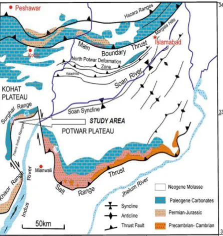
Surghar Range is the outer most fold-and-thrust belt of the sub-Himalayas making the eastern most extension of the Tran-Indus ranges (TIR) bifurcated by the KaIabagh fault system from the western Salt Range of North Pakistan Powel (1979). The range follows east-west structural trend along the southern margin of the Kohat plateau and switches to north-south trend along the eastern most flank of Bannu Basin (Fig. 1), (Khan and Opdyke, 1993). Along the range front the non-outcropping Permian to Eocene rocks underneath the Kohat and Bannu basins are exposed at surface. The range displays arcuate structural style in plan and exhibits distinct mountain forefront geometries along its map trace. It is characterized by south facing structures along its east-west trending segment. Whereas, the north-south trending segment of the range is dominated east vergent fold-thrust assemblages. The whole range displays bidirectional structural trend, north-south toward its sothern terminus to Malla Khel and oriented
east-west from Malla Khel to its eastern terminus up to junction of KaIabagh Fault Zone, making two broad segments. The north-south segment is composed of Siwalik sequence penetrated in progression by Eocene to Jurassic rocks from south to north in the proximity of Malla Khel village across the Baroch Nala section. The north-south oriented segment of the range is dominated by east facing structural geometries in additional to west vergent active back thrusting and tectonic wedging Ali, et al., (2014). Previous work is mostly attributed to stratigraphy, economic geology and geological mapping of the Surghar Range (Wynne, 1880; Danilchik and Shah, 1987;Khan et al., 1993) whereas its outer eastern flanks of the north-south segment and southeast flanks of the east-west segments have been remained unaddressed since long. Southern part of the north-south oriented segment is dominantly controlled by the uplifts of Siwalik sequence where Chinji Formation is exposed in the core of Qubul Khel Anticline. Near Sirkai, a broad anticline has been mapped in the Siwalik sequence where Mitha Khattak Formation and Sakesar Limestone
Copyright © SEGMITE
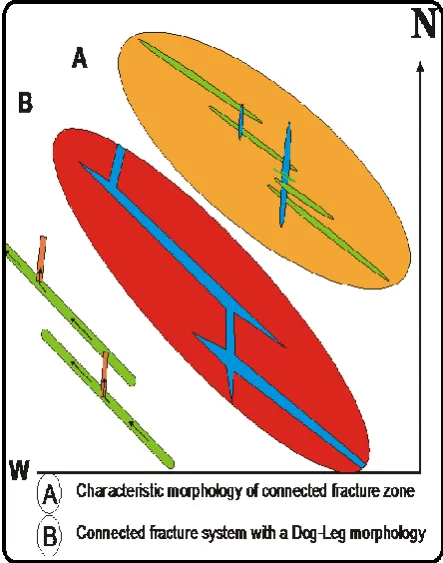
are thrust in the hanging wall over the Dhok Pathan Formation in the footwall. The structural geometries of east-west oriented segment are characterized by south facing overturned concentric anticlinal folds with a prominent south vergent thrust fault. The Sakesar Limestone is exposed and mapped along three major anticlinal folds right from northwest of Sirkia Village to Baroch Nala. These anticlines have been designated from south to north as Mitha Khattak, Makarwal and Malla Khel anticlines. The frontal limbs of these folds are thrust over Siwaliks Group rocks toward Punjab Foredeep. This thrust fault is observed laterally extended along the foothills of the range from Sirkia to the eastern terminus of the Surghar Range. Transpressional tectonics is the significant structural style of the north-south trending segment, while overturned concentric folding and thrust faulting is the dominant structural mechanism of the east-west trending segment of the range. Maturity in deformation style and variable stress regimes are observed from sothern plunging end to the eastern termination of the range all along the structural pathway in the form of tectonic progression, structural growth, maximum crustal shortening and unearthing of Paleozoic-Mesozoic rocks of the cover sequence. Maturity in the tectonic phases and exhumation of the older strata from interior to surface is well predictable. Sakesar Limestone has been studied for their reservoir potential by considering the growth of natural fractures and joints network developed attributable to the tectonic and diagenatic processes. The fractures network and their distribution are important parameter and essential prerequisite for the potential hydrocarbon reservoir. This well established fractures network is in hand in at the Sakesar Limestone all along the range. Beside this, connected fractures have been observed, which provide high permeability for the carbonate reservoirs and eventually helpful for the enhancement of yield (Fig. 10).
Fig. 1 Regional geological map showing the Trans-Indus ranges and present study area.
Material and Methods
This paper is comprised of data collected during geological field work in the Surghar Range for the radiometric prospection data acquisition of Cretaceous Lumshiwal Formation towards fore / frontal flanks of various anticlines exposed in the range for Atomic Energy Minerals Centre, Lahore. During the field work additional field structural data of unclassified nature of the Samana Suk Formation and Sakesar Limestone have also been acquired for the measurement and estimation of their fluid reservoir potential. Several field traverses have been made across the strike of the structural trend of different anticlines and acquired fractures / joints structural outcrop data of the Samana Suk and Sakesar Limestone. Geological and radiometric data acquisition gamma counters and instruments have been used in the field work.
Geo-structural setting
Pakistan occupies the northwestern structural province of the subducting Indian lithospheric plate underneath the Eurasian Plate. This global tectonic event has produced compressional and transpressional tectonic elements since Eocene on the northern and northwestern fringes of Pakistan. Continual under thrusting of the Indian Plate since Cretaceous created the amazing elevated mountain ranges of Himalaya and a series of foreland fold-and-thrust belts as thick sheets of sedimentary origin and thrust over the Indian Craton (Kemal, 1991).
The Trans-Indus extension of the Salt ranges is composed of several frontal ranges creates an “S” shaped double re-entrant and surrounds the Bannu Basin (Fig. 1). These ranges symbolize the western fraction of the northwestern Himalayan foreland fold-thrust belt that produced by continual south-directed décollement-related thrusting of the Indian Plate crust during long-term collision between India and Eurasia (Wells, 1984; Yeats and Hussain, 1987; Smith et al., 1994; Beck et al., 1995), crustal architecturing normally advanced southward with time space. The youngest and latest southernmost fracture zone has transpired along the fore front thrust mechanism contiguous to the Trans-Indus ranges (Khan et al., 1988, Alam, 2008) (Fig. 1). The current study area is the easternmost extension of the TIR (Fig. 2). Along the Surghar frontal fault Paleozoic to Cenozoic platform sequence is thrust southward over the undeformed Quaternary sediments of the Punjab Foredeep. The TIR characterized the foremost deformational front of the Kohat fold-thrust belt and Bannu Basin in North Pakistan. Consequently, the tectonic mode is generally observed thin-skinned for the outcropping structures.
Stratigraphic Framework
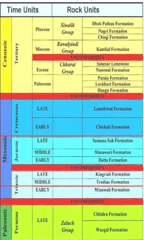
sediments of Siwaliks Group rocks (Table 1). The platform sediments become thicker and more complete from west to east along the range. In western part of range, northeast of Malla Khel in Baroch Nala and east of Pannu in the Chichali Nala excellent sections ranging in age from Permian to Miocene are exposed. The stratigraphic successions were studied along these sections of the range as shown in Table 1.
In this area, the base of stratigraphic succession is occupied by the Permian Zaluch Group rocks of Wargal Limestone overlain by the Chhidru Formation. This succession is occupied by the Triassic sequence of Musa Khel Group rocks of Mianwali, Tredian and Kingriali Dolomite overlying the Jurassic sequence that include Datta, Shinawari and Samana Suk Formation. On top the Cretaceous sequence is mapped and comprised of Chichali and Lumshiwal formations unconformably overlain by Paleocene sequence that comprised of Hangu, Lockhart and Patala formations. In turn the sequence is overlain by the Eocene Nammal Formation and Sakesar Limestone, which is unconformably overlain by the Mitha Khattak Formation and Siwalik Group rocks, makes the apex of the stratigraphic profile.
Table 1: Stratigraphic framework of the Surghar Range (after Danilchik et. al., 1987).
5. Reservoir Potential of Sakesar Limestone
Following prominent fold structures have been mapped from south to northeast toward the frontal flanks of the Surghar Range exposing Sakesar Limestone of Eocene (Fig. 2). Medium to thick beds of the Sakesar Limestone make the hanging wall ramp of the frontal thrust sheet against the Siwaliks sequence in the footwall toward the Punjab Foredeep. The Sakesar Limestone is developed throughout the Surghar Range is a hard prominent cliff-forming formation. The limestone horizon maintains a relatively uniform character all over the area. It consists of white to whitish gray, greenish gray to gray, nodular, medium to thick bedded limestone with alternate thin marl beds. Chert concretions are frequently observed in middle and upper parts of the limestone. The whole limestone is well fossiliferous, highly fractured, jointed, moderate to rationally cavernous and visible to measurable beds disjointing have been observed in the outcrop exposure. Random joints and fissures have been observed along the bedding planes making the horizon well porous and permeable. Thickness of the Sakesar Limestone in the Landa Psha section is 128 meters whereas in the Makarwal section of the Surghar Range is 300 meters (Ali, 2010). Thickness reported 220 meters in Chichali section and 600 meters at Makarwal area (Danilchik and Shah 1987). Physical characteristics including its lateral extension, thicknesses, primary and secondary connected and unconnected fractures fabricate its permeability and storage capacity of the formation is appropriate and in hand basic parameter for the reservoir potential of the horizon. Its lower contact with the Nammal Formation and upper contact with the Chinji Formation both comprised of thick shale beds making the seal horizons, observed conformable and unconformable respectively. The Sakesar Limestone evolved in open marine carbonate depositional environment (Tectostrat, 1992) during early Eocene.
Mitha Khattak Anticline (MKA)
This anticline is mapped north of Mitha Khattak village and comprised of rocks of the Siwaliks Group underlain by the Eocene Sakesar Limestone and Nammal Formation. The Eocene rocks are underlain by the Paleocene Patala Formation and Lockhart Limestone. Base of the Lockhart Limestone is not exposed in the core of MKA. The anticline is facing to east and plunging to south. The eastern limb is steeply dipping to southeast to make the anticline is overturned.
at an angle of 75° 80°SE (Fig. 3).
Fig. 3 Photograph showing the Mitha Khattak and Eocene Nammal and Sakesar formations exposed in the Mitha Khattak Anticline (MKA).
Joints Data
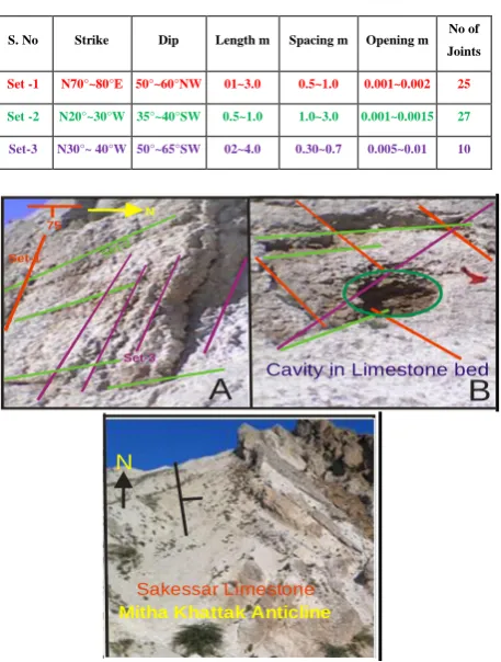
Joints data has been collected on the eastern limb of the MKA on the exposed beds of Sakesar Limestone observed highly fractured tectonically and diagenatically. Tectonically, induced three different joint sets have been observed and acquired data of each parameter, which is tabulated below (Table 2).
Table 2. Showing joints trend along with dimensional data of the Sakessar Limestone in MKA.
S. No Strike Dip Length m Spacing m Opening m No of Joints
Set -1 N70°~80°E 50°~60°NW 01~3.0 0.5~1.0 0.001~0.002 25
Set -2 N20°~30°W 35°~40°SW 0.5~1.0 1.0~3.0 0.001~0.0015 27
Set-3 N30°~ 40°W 50°~65°SW 02~4.0 0.30~0.7 0.005~0.01 10
N
75 Set-1 Set-2
Set-3
A
B
Mitha Khattak AnticlineN
Sakessar Limestone
Cavity in Limestone bed
N 75
Set-1 Set-2
Set-3
A
B
Mitha Khattak Anticline N
Sakessar Limestone
Cavity in Limestone bed
Fig. 4 Photographs showing Joint system in the Sakesar Limestone exposed in the eastern limb of MKA.
B
Malla Khel
Karandi
Dhok Pathan
Nagri
Chinji
Eo ce ne Pa le oc en e Cre ta ce ou s Sa m an a S
uk Sh in aw ari Da tta Sa m an a +
Sh ina wa ri Eo ce ne Kingriali Tre dia n M ia nw a li Ch inji
Mitha Khattak Frm
Alluvium
N
Scale
0 1000 2000m
32 55 32 57 7 1 0 5 71 15 50 65 45 45 40 46 30 40 Surghar Thrust
A
32 55 32 57 Ka ra nd i Anti cli
ne
M all
a K he
l A nti
cli ne
The surface exposure of Sakesar Limestone observed highly fractured, jointed, vugy and showing nodulation. Visible and splitted bedding planes,
longitudinal and transverse joints pattern, chicken wire net fractures and existence of elliptical to circular holes at right angle to strike make the horizon encouraging reservoir for fluid circulation as well as potential storage compartment (Fig. 4).
Karandi Anticline (KA)
Rocks exposed on the eastern limb of KA are the Mitha Khattak and Chinji formations. The Eocene
Nammal Formation and Sakesar Limestone are thrust eastward on the Mitha Khattak Formation in the hanging wall. The oldest formation exposed in core of
the KA is the Cretaceous Lumshiwal Formation, where base of the Lumshiwal Formation is not exposed in the core. General trend of the strata is N5°~10°W and dipping steeply toward 80°SW. Tectonically induced joints trend and other diagenetic apertures up to13 cm diameters, data have been acquired of the Sakesar Limestone to determine its reservoir potential capability in the region. The obtained data are tabulated below and shown in Table 3.
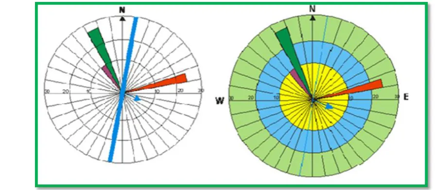
Fig. 5 Joints Rose diagram along with structural trend data of Sakesar Limestone eastern limb of MKA.
Table 3. Showing joints trend along with dimensional data of the Sakessar Limestone, KA.
S. No Strike Dip Length m Spacing m Opening m No of Joints
Set -1 N68°~75°W 70°~80°SW 0.3~2.0 0.2~0.5 0.001~0.002 12
Set -2 N20°~25°E 50°~56°SE 0.5~4.0 1.0~3.0 0.01~0.15 15
Set-3 N55°~ 60°E 50°~65°NW 0.5~3.0 0.5~1.5 0.01~0.03 12
A B
N
E W
0
90 90
Class Interval 03 degrees
The limestones are medium to thick bedded showing prominently bidirectional joint pattern with some visible circular to semicircular openings. The fracture density visually observed high at the outcrop level.
The same density is expected to be existed at the subsurface level because these ruptures are the product of diagenetic as well as tectonic process. The Sakesar Limestone is virtually considered as potential reservoir for the accumulation of hydrocarbon in the Surghar Range (Fig. 6).
Malla Khel Anticline (MKhA)
The Malla Khel Anticline is located northwest of Malla Khel village. It is a prominent structural feature of the region. The frontal limb of the anticline is overturned. The back limb of the anticline is gently dipping to northeast. While, its forelimb is asymmetrical to overturned and dipping at high angle ranging from 80-85o northeast. The oldest Datta Formation is exposed in its core. In frontal flank, Eocene strata are thrust in a hanging wall ramp over Siwaliks in the footwall ramp. Geometry of the anticline revealed as fault bend-fold (Fig. 2). Generalized structural transect along line AB of the geological map has been constructed and shown in Fig. 7. The cross section shows that the Triassic rocks are entrapped in the core of the Malla Khel Anticline, whereas the Datta Formation of Jurassic exposed in the core of Karandi Anticline.
Fig. 7 Generalized cross-section constructed along the AB line of geological map.
General structural orientation of beds is N05~10°E and steeply dipping to 80°~88°NW~NE. Secondary induced joints/fractures trend along with diagenatically produced openings data has been acquired along the frontal limb of anticline of the Sakesar Limestone to reveal its fluid
reservoir potential in the Surghar Range. The collected data are tabulated below in Table 4.
The surface exposure of the Sakesar Limestone observed remarkably fractured, jointed by penetrative strain with the creation of open bedding planes. Some major dissolution of the primary minerals observed in the form of cavities which is responsible for the enchantment of permeability of the desired horizon (Fig. 9).
Fig. 8 Photographs showing overturned Malla Khel Anticline, Surghar Range
N
E W
0
90
90 3 6 9 12 15 18 21
Class Interval
03 degrees Unit Area
Fig. 9 Fractures in Sakesar Limestone along with rose diagram of Malla Khel Anticline.
Table 4. Joints trend and diagenetic apertures data of the Sakesar Limestone, MKhA.
S. No Strike Dip Length m Spacing m Opening m No of Joints
Set -1 N40°~60°W 65°SW~Vert 0.2~1.0 0.5~ 2.0 0.001~0.0015 15
Set -2 N20°~25°E 30°~40°SE 0.5~2.0 0.5~1.5 0.002~0.004 18
Results and Discussion
Tectonics and structural deformations in the Surghar Range is younger proportional to the northern mountain belts of the inner Himalayas. This outermost frontal fold-and-thrust belt of the sub-Himalayas is comprised of latest tectonic and local to regional scale structural features well developed in the frontal flanks of the range. The mapped folds and faults are the products of compressional to transpressional tectonic regime. The Surghar Range is an arcuate feature and bounded all along its periphery by the combination of major thrust and local scale strike slip faults. The younger segment of the range is north-south oriented whereas the well-grown segment of the range is east-west oriented. The southern plunging terminus of the range is bounded by the Kundal strike-slip fault whereas the eastern terminus of the range is bounded by the Kalabagh fault system. The northwestern border is demarcated by the Karak Thrust fault and the southeastern perimeter is decoupled by the Surghar Range forethrust. The in-between compartmentalized area is comprised of small to large sized force folds being the product of fault-bend and fault-propagation compressional phenomenon. The oldest Paleozoic sequence of Permian rocks is cropped out along the frontal thrust sheet and protrudes southeastward against the Punjab foredeep. In structural route from south to east along the range, different stratigraphic horizons have been exhumed along the frontal ramp revealing detachment flux from the prime basal décollement. The Eocene strata towards south and Permian strata toward east along the range front have thrust over Siwaliks in the footwall ramp. The outcrop exposure of the rocks along the range front is remarkably fractured and jointed. The Sakesar Limestone of Eocene has been selected for detailed fractures analysis to show its hydrocarbon reservoir potential along the eastern and southeastern flanks of the range. These structural defects have been observed that they are the products being induced tectonically and diagenatically during depositional phase of the Sakesar Limestone. The tectonically induced fractures are elongated reveal systematic and preferred orientations, joint spacing and joint openings/apertures. Three different joint sets have been observed at three different observatory stations at three different anticlines along the range front shown high fracture density. Some of the unsystematic/random joints and fractures have also been observed at each location raises the reservoir capability of the Sakesar horizon. The diagenetic apertures are generally shown on the photographs in the form of circles, because they are more or less spherical in appearance. The sizes of sphere and their openings are significantly larger than the secondary tectonically induced fractures. The inner diameter walls of the spheres are uneven, rough and harsh and reveal the dissolution of some unstable minerals mass subsequent to their deposition.
The differences in fracture directions that might disclose differences in the regional tectonic stress
patterns between the two time periods. Most of the joint patterns are observed interconnected with each other and give dog-leg morphology (Fig. 10). Visually the fracture density in the Sakesar Limestone horizon observed greater in the east-west trending segment as compared to the north-south trending segment of the range. These fractured rocks facilitate the fluid storage capacity and transmissivity along the medium to enhance the reservoir quality of the Sakesar Limestone. That’s why one of the most essential prerequisites for the hydrocarbon accumulation is in hand in the Surghar Range, Trans-Indus Ranges of the outer Himalayan Orogenic province of north Pakistan.
Fig. 10 Showing characteristics of connected and dog-leg fracture morphology (modified after Jamison, W. R., 1998).
Conclusion
observed and shown equally high fracture density which also raises the reservoir potential of the Sakesar horizon. Most of the fractures are of dual nature generated in diagenetic and post diagenetic environments. These fractures and joints are observed interconnected with each other and give dog-leg morphology. At the outcrop level the fracture density of the Sakesar Limestone horizon observed greater in the east-west trending segment as compared to the north-south trending segment of the range. These fractured lithology make possible the fluid accumulation capacity and permeability along the medium to improve the reservoir worth of the Sakesar Limestone. Hence, one of the most essential prerequisites for the hydrocarbon accumulation is in hand in the Surghar Range, Trans-Indus Ranges of the outer Himalayan orogenic province.
Acknowledgement
This research work is based on data collected during field work for Lumshiwal Formation in the Surghar Range for Atomic Energy Minerals Centre Lahore. Authors acknowledge the financial support and facilities provided by Mr. Muhammad Ali Sheikh, Ex-Director General, AEMCL to arrange field work in the Surghar Range.
References
Alam, I. (2008). Structural and stratigraphic framework of the Marwat-Khisor ranges, N-W.F.P, Pakistan. Unpublished Ph.D. Thesis submitted to NCEG, Univ. of Pesh, Pak., 142pages.
Ali, A. (2010). Structural analysis of the TIR: Implication for the hydrocarbon potential of the NW Himalayan, Pak. Unpublished Ph.D. Thesis, submitted to NCEG, Univ. of Pesh. Pak., 1~259.
Ali, F., Khan, I. M., Ahmad, S., Rehman, Ali, H. T. (2014). Range front structural style: An example from Surghar Range, north Pakistan, JHES, 47 (2), 193-204.
Beck, R. A., Burbank, D. W., Sercombe, W. J., Riley, G. W., Brandt, J. R., Afzal, J., Khan, A. M., Jurgen, H., Metje, J., Cheema, A., Shafique, A., Lawrence, R. D. & Khan, M. A. (1995). Stratigraphic. evidence for an early collision between NW India and Asia. Nature, 373, 55-58.
Danilchik, W., Shah, M. I. (1987). Stratigraphic and coal resources of the Makarwal area, TIR, Mianwali District, Pakistan. U.S. Geological Survey, Prof. Paper, 131, 38 pages.
Jamison, W. R. (1998). Quantitative evaluation. of fractures on Monkshood Anticline, a det. fold in the foothills of western Canada. AAPGB., 81 (7), 1110-1132.
Kemal, A. (1991). Geology and new trends for hydrocarbon exploration in Pakistan. Proceedings, International petroleum seminar Ministry of Petroleum and Natural Resources, Islamabad, Pakistan, 16-57.
Khan, M. J., Opdyke, N. D. (1993). Position of Paleo-Indus as revealed by the mag. Strati. of the Shinghar-Surghar Ranges, Pak. In: Himalaya to sea: geology, geomorphology and the Quaternary, J. F. Shroder (ed.), Rutledge Press, London, 198-212.
Khan, M. J., Opdyke, N. D., Tahir Kheli, R. A. K., (1988). Magnetic stratigraphy of the Siwalik Group, Bhittani, Marwat and Khisor ranges, north-western Pakistan and the timing of Neogene tectonics of the Trans-Indus. J. Geophy. Res., 93, 773-790.
Powell, C. M. A. (1979). A speculative tectonic history of Pakistan and surroundings: some constraints from the Indian Ocean. In: Farah, A. and DeJong, K. A., (eds.) Geodynamics of Pakistan. Geological Survey of Pakistan, Quetta, 5-24.
Smith, H. A., Chamberlain, C. P., Zeitler, P. K. (1994). Timing and duration of Himalayan metamorphism within the Indian plate, NW Himalaya, Pak. J. of Geo., l02, 493-503.
Tectostrat, (1992). Trans-Indus and Salt Range Study Report.
Wells, N. A. (1984). Marine and continental sedimentation in the early Cenozoic Kohat Basin and adjacent northwestern Indo-Pak: Ann Arbor, University of Michigan, Ph.D. dissertation, 465 pages.
Wynne, A. B. (1880). On the Trans-Indus extension of the Punjab Salt Range. India Geol. Survey Mem. 17(2), 95 pages.
Yeats, R. S., Hussain, A. (1987). Timing of structural events in the Himalayan foothills of north-western Pakistan. Geological Society of America Bulletin, 99, 161-175.