Satellite tracking of kereru (
Hemiphaga novaeseelandiae
) in Southland, New Zealand:
impacts, movements and home range
Ralph G. Powlesland
1*, Les R. Moran
1, and Debra M. Wotton
1,21Research & Development Group, Department of Conservation, PO Box 10-420, Wellington 6143, New Zealand 2Present address: Landcare Research, PO Box 40, Lincoln 7640, New Zealand
*Author for correspondence (Email: rpowlesland@doc.govt.nz)
Published on-line: 21 March 2011
Abstract: Satellite transmitters (PTTs) were attached to four kereru (New Zealand pigeon, Hemiphaga novaeseelandiae) in Invercargill, Southland, New Zealand, during 2005–06. The transmitters were used to monitor the birds’ locations, movements and home ranges. Attachment of the transmitters affected the behaviour and body condition of one of the kereru; no other negative effects, such as skin abrasion, were noticed. Fifty-four percent of locations recorded were of Argos location classes 1, 2 or 3 (accuracy of ≤1 km), and were used to determine the birds’ movements and home range areas. Three of the kereru made flights across Foveaux Strait (a minimum distance of 33 km) to Stewart Island; the other remained around Invercargill. The maximum distance between their locations ranged from 11.4 to 101.9 km. Home ranges, as determined by cluster analysis, ranged from 619 ha to 31,732 ha, 100–1000 times greater than kereru home range areas estimated in previous studies. Given the long-distance movements kereru make, often to locations distant from roads and tracks, satellite telemetry is probably the most reliable and cost-effective method of determining their locations.
Keywords: cluster analysis; minimum convex polygon; New Zealand pigeon; transmitter; weight change
Introduction
The kererū (New Zealand pigeon, Hemiphaga novaeseelandiae) is a ‘Not Threatened’ large endemic pigeon (Miskelly et al. 2008). It occurs through much of North, South and Stewart islands, on some offshore islands (Robertson et al. 2007), and in a variety of habitats, including extensive tracts of podocarp–hardwood forest, Nothofagus forest, forest remnants, exotic plantations, farmland, and urban parks and gardens (Heather & Robertson 2005).
Until recently, kererū were thought to be the only remaining New Zealand bird capable of dispersing large-fruited tree species (McEwen 1978; Clout & Hay 1989). However, Kelly et al. (2010) have shown that most large-fruited species produce some smaller fruit that can be swallowed by mid-sized bird species that are still widely distributed, such as tūī (Prosthemadera novaezelandiae). However, the effective dispersal of seeds depends not only on birds’ abilities to swallow large fruits, but also on the extent and frequency of their movements. Much of New Zealand’s remaining native forest occurs in relatively small fragments. Long-distance seed dispersal may be particularly important in maintaining small, isolated populations of large-seeded trees within these remnants (Purves & Dushoff 2005; Wotton 2007). In addition, the majority of gene flow among plant populations appears to occur via seed dispersal (Hamilton 1999; García et al. 2007). Restricted dispersal among populations can lead to reduced genetic diversity and may increase the risk of extinction (Shapcott 2000). The effects of inbreeding appear to be particularly severe in trees and shrubs, with complete mortality of inbred offspring prior to maturity (Scofield & Schultz 2006). Thus movements of fruit-eating bird species, such as kererū, may have significant repercussions for the maintenance of fleshy-fruited tree populations in fragmented landscapes.
While individual kererū often spend several days or weeks making only small movements within a limited geographical range (<5 ha) (Clout & Hay 1989; Bell 1996), such periods can be followed by extensive movements of several kilometres (Clout et al. 1986, 1991; Pierce & Graham 1995; Hill 2003; Schotborgh 2005; Campbell 2006; Stevens 2006). Some kererū movements can involve flights of more than 10 km (Clout et al. 1986, 1991; Harper 2003; Hill 2003) between discrete areas of their home ranges (Clout et al. 1986; Hill 2003; Stevens 2006).
Researchers have previously relied on the use of VHF transmitters attached to kererū to locate individuals at regular intervals (Clout et al. 1986, 1995; Powlesland & Willans 1997; Powlesland et al. 2003; Innes et al. 2004). Locating widely dispersed radio-tagged kererū with such transmitters is expensive and time-consuming; moreover, tracking them from a motor vehicle, light plane or helicopter is not always successful. Thus, development of satellite telemetry and smaller transmitters (≤20 g) has enabled this technology to be used on kererū (Kenward 2001; Soutullo et al. 2006). Here we report on a pilot study into the suitability of satellite telemetry to monitor the movements and home ranges of four kererū in Southland. This study was part of a 4-year study into various aspects of the ecology of kererū and tūī, particularly their foods, movements, mortality and nesting success, in urban and rural landscapes about Invercargill and New Plymouth (Powlesland et al. 2007, 2008).
Methods
Kererū capture, handling, transmitter attachment, and sexing
Three kererū were captured in mist-nets erected using aluminium poles (Dilks et al. 1995), with two of these kererū
being recaptured the same way. A fourth bird was tagged with a satellite transmitter while in captivity recuperating from injury sustained after flying into a window. We used satellite transmitters (platform transmitter terminals; PTT-100, Microwave Telemetry Inc., Columbia, MD, USA) that weighed 20 g, were battery-powered, and had a transmission life of 400 h – just 17 days (more details at http://microwavetelemetry. com). To extend the potential field life of the transmitters, the following duty cycles were used: 6 h on, 48 h off (148 days of field life); 5 h on, 72 h off (257 days), and 4 h on, 84 h off (367 days) (Table 1). The on or transmission period of the duty cycle is when the transmitter is signalling to satellites. The satellite transmitters were attached to the birds using a back-mounted harness (c. 3.5 g) developed by Karl and Clout (1987). Satellite transmitter signals were picked up by Argos® satellites that use the Doppler Effect to determine the transmitter’s location (Nicholls & Robertson 2007). The location information is relayed to a central computer in France, which the researcher can download via the Internet. Thus signals from satellite transmitters could not be tracked to their source by a person on foot with a receiver and antenna.
Because kererū sometimes suffer post-handling shock (become grounded and unable to fly) following transmitter attachment (Clout et al. 1995; Powlesland et al. 2003), two additional procedures were carried out. The first was the attachment on three of the four birds of a 3.8-g VHF two-stage transmitter (Sirtrack, Havelock North, NZ) to the top of the satellite transmitter with a piece of adhesive tape so that the kererū could be located daily for the first week after release. One of the VHF transmitters remained attached for 10 weeks; the fate of the other transmitters is unknown. The weight of the complete package (satellite transmitter, VHF transmitter and harness) was c. 27.3 g. Thus the package represents c. 4% of a Southland kererū’s bodyweight (mean = 686 g, SD = 51.9, range = 585–790, n = 33). The second procedure
involved administering 20 ml of Hartmann’s solution or 20 ml of a glucose solution (1 teaspoon of glucose dissolved in distilled water) directly into the bird’s crop. This was done in an effort to provide an easily assimilated energy supplement and liquid to assist a shocked bird through the first few hours after its release. Following release, each kererū with a VHF transmitter was located and checked twice daily for the first two days, and then once daily for another five.
At the initial capture of each kererū, a few dislodged feathers were collected from the weighing bag. These were submitted to the Equine Blood Typing & Research Centre, Massey University, Palmerston North, for gender determination by DNA (Griffiths et al. 1998).
Locations from Argos
The number of days that satellite transmitters were active (i.e. provided location data) ranged from 42 to 305 (mean = 155) (Table 1). The number of locations per transmitter ranged from 99 to 339 (mean = 221), as a result of both duty cycle and actual transmitter field life. Locations provided by the Argos system were divided into different classes (labelled Z, B, A, 0, 1, 2, 3 in ascending order of accuracy). Only location classes 1, 2 and 3 were used in analyses because they provide reasonably accurate estimates of locations, 1 km, 350 m and 150 m respectively. These high-quality locations (LC 1–3) represented 54.6% of our total data set. During transmitter transmission periods a mean of 2.2 high-quality locations were obtained (Table 2), which is a similar rate to that found in two other studies (Hake et al. 2001; Jourdain et al. 2008).
Estimation of movement distance and home range area
Movement distance was estimated using the statistical programme R (version 2.8.0; R Development Core Team 2008) using package ‘adehabitat’ (version 1.8.0; Calenge 2006).
Table 1. Details for each adult kererū that was fitted with a PTT (platform terminal transmitter) transmitter in Southland, New Zealand: sex, period when PTT was active, duty cycle, kererū percentage weight change between capture and recapture, and location information.
__________________________________________________________________________________________________________________________________________________________________
Band no. Sex PTT active period PTT duty Weight Locations LC 3, 2 or 1 LC 3, 2 or 1
(days active) cycle change (n) locations locations per
(%) (%) transmission period1 (n)
__________________________________________________________________________________________________________________________________________________________________
K-14403 Male 26 January 2005 to 5 h on, +4.7 108 50.0 54/34 = 1.6
05 May 2005 (100) 72 h off
K-14403 Male 28 November 2005 to 6 h on, +1.3 99 53.5 53/17 = 3.1
(recapture) 08 January 2006 (42) 48 h off
S-80578 Female 02 December 2005 to 6 h on, -13.5 339 66.4 225/53 = 4.2
18 April 2006 (138) 48 h off
K-12304 Female 21 December 2005 to 6 h on, - 263 39.9 105/88 = 1.2
28 June 2006 (190) 48 h off
S-80580 Female 13 January 2006 to 4 h on, - 298 56.4 166/80 = 2.1
13 November 2006 (305) 84 h off
__________________________________________________________________________________________________________________________________________________________________
1Transmission or ‘on’ period of the duty cycle is when the transmitter is signalling to satellites.
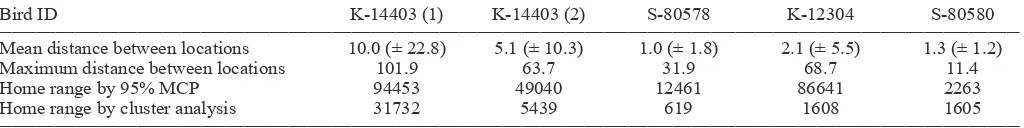
Table 2. Distance moved (km) and home range (ha) estimations using cluster analysis and 95% minimum convex polygons for four satellite-tagged kererū in Southland, New Zealand.
__________________________________________________________________________________________________________________________________________________________________
Bird ID K-14403 (1) K-14403 (2) S-80578 K-12304 S-80580
__________________________________________________________________________________________________________________________________________________________________
Mean distance between locations 10.0 (± 22.8) 5.1 (± 10.3) 1.0 (± 1.8) 2.1 (± 5.5) 1.3 (± 1.2)
Maximum distance between locations 101.9 63.7 31.9 68.7 11.4
Home range by 95% MCP 94453 49040 12461 86641 2263
Home range by cluster analysis 31732 5439 619 1608 1605
In addition, the same package was used to estimate home range area using both cluster analysis (Kenward 2001) and minimum convex polygons (MCP). A 95% threshold was used to exclude outliers from home range calculations for both methods. Previous studies have identified that kererū home ranges often include two or more discrete areas separated by several kilometres (Clout et al. 1986; Hill 2003; Stevens 2006). Cluster analysis of nearest-neighbour distances between locations enables multiple high-usage areas to be distinguished within home ranges (Kenward 2001) and therefore is the most appropriate method for estimating kererū home ranges. We included MCP results to allow comparison with results from earlier studies of kererū home range, and to illustrate how this method can provide a misleading home range estimate when kererū core areas are separated by extensive unused areas.
Results
Impacts of transmitters on weight and feathering
Satellite transmitters, their harnesses and the attached VHF transmitters represented 3.0 – 4.7% of the four birds’ capture weights. The two birds (K-14403, K-12304) that had been carrying VHF transmitters before being deployed with satellite transmitters showed no ill effects of the capture and handling procedures. Similarly, S-80580, the bird that had recuperated from window strike, flew off strongly when released and appeared to behave normally during the following week. In contrast, S-80578 was found on the ground in a weakened state on the fourth day after transmitter attachment. She was taken into captivity, the transmitter was detached then reattached 2 weeks later, and she was then re-released a further two weeks later. This bird behaved normally thereafter.
Two of the kererū were recaptured after about a year of carrying a satellite transmitter. The weight of K-14403 had increased by 4.7% over the 10-month period he carried his first transmitter, and by a further 1.3% during the 12-month Figure 1.
Figure 1. Home ranges of four
satellite-tagged kererū in Southland and Stewart
Island, New Zealand, as determined by cluster analysis for locations obtained during 2005–06.
period that he carried the second transmitter (Table 1). In contrast, S-80578 had lost 13.5% of her bodyweight when the transmitter was removed, but had gained 8.7% following her release from captivity.
On none of the three occasions that the above two birds were recaptured did they show any evidence of skin abrasion or callusing as a result of carrying satellite transmitters. The feathers under and adjacent to where the transmitters were positioned on the birds’ backs were ruffled, but no skin was exposed.
Movements
The satellite-tagged kererū spent variable time resident in a relatively small area, interspersed with movements to new locations, occasionally of many kilometres. For example for the first 47 days after being radio-tagged, K-12304 remained within 2 km of the capture site near Invercargill. Subsequently she was located near Bluff, and then 2 days later, having crossed Foveaux Strait, was located in northern Stewart Island where she remained for more than 4 months (Fig. 1). Similarly, within 4 days of being radio-tagged, K-14403 flew from Invercargill to Greenpoint near Bluff, and then 3 days later, when further data were received, the bird was near Port William, Stewart Island (Fig. 2). K-14403 remained in the Port William area and then near Horseshoe Bay, Stewart Island, for 6 weeks. However, during the next 7.5 weeks he made at least four crossings of Foveaux Strait, and flew more than 480 km during a 100-day period. In contrast, S-80580 remained within c. 5 km of her release site throughout the 305-day period her transmitter provided location data (Fig. 1). Overall, the mean distance between locations of the four kererū varied from 1.0 to 10.0 km, and the maximum distance 11.4 to 101.9 km (Table 2).
Home range
Figure 2. Movements of K-14403, an adult
male kererū, from 26 January to 5 May
2005 in Southland and Stewart Island, New Zealand.
732 ha for the four birds (Fig. 1), while the minimum convex polygon method gave areas from 2263 ha to 94 453 ha (Fig. 3). While the two methodologies gave similar-sized home ranges for female S-80580, they gave quite different results for the other three kererū, with the MCP method giving home ranges 3–54 times greater than cluster analysis (Table 2).
Each of the satellite-tagged kererū centred its movements within more than one area during the study. K-14403 spent most time in three areas, but also stayed briefly (<4 days duration) at five other areas. The two females that flew to Stewart Island occupied three areas, while S-80580, which remained about Invercargill, occupied two.
Discussion
Impacts of capture and transmitter attachment
Of the four kererū used in this study, the one that had never been handled before responded negatively to handling and transmitter attachment. Even though most kererū coped well with handling and weight of transmitters and harness, appearing to behave normally and three making long-distance movements across Foveaux Strait, we think it advisable to reduce package weight in accord with the recommendation that back-mounted transmitters attached to flighted birds should be ≤3% of bodyweight (Kenward 2001; Redfern & Clark 2001). Now that 9.5-g and 12-g solar-powered satellite transmitters are available, such transmitters plus harness and VHF transmitters would constitute c. 2% of a Southland kererū’s bodyweight and may be a better option for monitoring kererū movements. We recommend that if satellite transmitters are attached to kererū small VHF transmitters continue to be attached as well so the tagged kererū can be readily located and their well-being checked daily for about a week after release.
Movements
Kererū occasionally make long-distance movements (>1.5 km) in between weeks or months of fairly sedentary behaviour (Clout et al. 1986, 1991; Hill 2003; Schotborgh 2005; Campbell 2006; Stevens 2006). These long-distance movements may involve sea crossings, for example between Cape Rodney and Little Barrier Island (21.5 km) (L. Whitwell & S. McInnes, Department of Conservation, pers. comm.) and between Southland and Stewart Island (c. 33 km) (Harper 2003). Thus, the general behaviour of the four satellite-tagged kererū and the extent of their movements were not unusual. However, the frequency of the long-distance movements, including repeated traverses of Foveaux Strait, undertaken by K-14403 was unexpected. It is possible that he was unpaired and that his movements involved attempts to find a mate as he was never regularly seen roosting closely with another kererū while in Invercargill. Bell (1996) found that unpaired immature kererū had significantly larger home ranges than adults and made more long-distance movements.
The three satellite-tagged kererū that moved from Invercargill to Stewart Island did so during December–March. The timing of these movements related well to the start of the main nesting season of kererū in Southland. While a few eggs were laid during August–November of the three breeding seasons covered by the study (2003/04, 2004/05, 2005/06), the majority were laid during December–March (RGP & LRM unpubl. data). Even though none of the satellite-tagged kererū could be located and observed when on Stewart Island, the timing of their departures suggests that they were going there to breed. Similarly, some kererū at Whirinaki Forest Park (Hill 2003) and Pelorus Bridge Scenic Reserve (Clout et al. 1991) made long-distance movements during late spring – early summer between wintering and breeding sites.
Home range area
Figure 3. Home ranges of four
satellite-tagged kererū in Southland and Stewart
Island, New Zealand, as determined by the 95% Minimum Convex Polygon method (outliers removed) for locations obtained during 2005–06.
for estimating kererū home range size than the minimum convex polygon approach, especially when discrete areas of an individual’s home range are separated by large areas of unused habitat. This is illustrated by the three kererū that had home range core areas in both mainland Southland and Stewart Island. Minimum convex polygon analysis included Foveaux Strait, obviously unusable habitat, within the home range areas of these kererū.
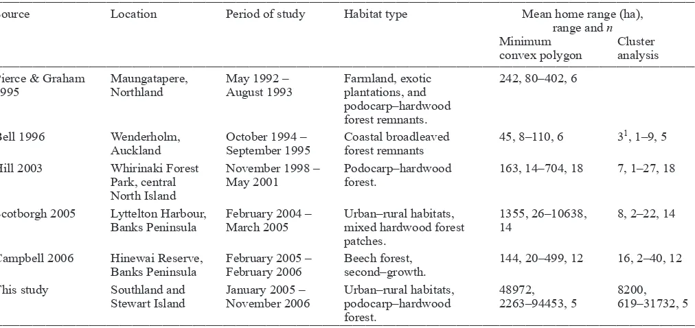
Home range areas were far larger for the four kererū monitored during our study than those previously recorded (Table 3). Even the cluster analysis results were still 100–1000 times greater than those obtained from other studies. Possible reasons for this difference includes habitat quality and that all four of the kererū in our study had home ranges that included two or more disparate areas. Compared with regions further north and especially compared with the North Island, Southland kererū habitat is of lesser quality, has fewer native plant species producing fruit >10 mm in diameter, and fleshy-fruited plants comprise a lesser proportion of the woody basal area (Kelly et al. 2010). For example, at Maungatapere, near Whangarei (Pierce & Graham 1995), at Wenderholm, near Auckland (Bell 1996), and at Hinewai Reserve on Banks Peninsula (Campbell 2006), suitable food sources appeared to be available year round within relatively small areas. Consequently, kererū did not move more than a few kilometres.
The ability of satellite transmitters to collect kererū location data at widely separated sites may also have contributed to the larger estimates of home range size in this study compared
with previous studies using radio transmitters. Several authors have reported the ‘disappearance’ of tagged kererū during radio-tracking studies (Pierce & Graham 1995; Bell 1996; Schotborgh 2005; Campbell 2006). Thus home range estimates for some kererū carrying VHF transmitters are likely to be underestimates of home range size.
Conclusions
In most studies that have involved radio-tagging kererū the occasional bird has suffered from post-capture trauma, with some kererū becoming grounded within a few days of having a transmitter attached. With appropriate care in captivity they generally recuperate within a week. Retagging a bird while it is still in captivity enables it to be monitored closely before being released. However, given the possible deleterious reaction to manipulations, it is essential that each radio-tagged kererū is checked daily for a week after release or until such time that it is feeding and flying readily.
Table 3. Comparison of home range estimates for kererū during six studies as determined by minimum convex polygon and cluster analysis methods.
__________________________________________________________________________________________________________________________________________________________________
Source Location Period of study Habitat type Mean home range (ha),
range and n
Minimum Cluster convex polygon analysis
__________________________________________________________________________________________________________________________________________________________________
Pierce & Graham Maungatapere, May 1992 – Farmland, exotic 242, 80–402, 6
1995 Northland August 1993 plantations, and
podocarp–hardwood forest remnants.
Bell 1996 Wenderholm, October 1994 – Coastal broadleaved 45, 8–110, 6 31, 1–9, 5
Auckland September 1995 forest remnants
Hill 2003 Whirinaki Forest November 1998 – Podocarp–hardwood 163, 14–704, 18 7, 1–27, 18 Park, central May 2001 forest.
North Island
Scotborgh 2005 Lyttelton Harbour, February 2004 – Urban–rural habitats, 1355, 26–10638, 8, 2–22, 14 Banks Peninsula March 2005 mixed hardwood forest 14
patches.
Campbell 2006 Hinewai Reserve, February 2005 – Beech forest, 144, 20–499, 12 16, 2–40, 12 Banks Peninsula February 2006 second–growth.
This study Southland and January 2005 – Urban–rural habitats, 48972, 8200, Stewart Island November 2006 podocarp–hardwood 2263–94453, 5 619–31732, 5
forest.
__________________________________________________________________________________________________________________________________________________________________ 1Determined by peeled polygon.
only cost-effective method of obtaining daily locations to fully detail movements, home range and habitat use.
One drawback observed during our study was the limited transmission life of the satellite transmitters. Even with a duty cycle incorporating much time off (4 h on, 84 h off), transmission life was only one year. Given that kererū occasionally travel several kilometres in a day, and that timing of movements and locations of individuals can differ between years as a result of food availability (Clout et al. 1991), transmission life needs to be at least 2 years. Solar-powered transmitters have the potential to provide the increased transmission life needed and should be trialled on kererū.
Native forest in New Zealand has become fragmented because much has been converted to pasture and exotic plantations, especially in the lowlands. The ability of kererū to make long-distance flights (McEwen 1978; Clout et al. 1991; Pierce & Graham 1995; Karan 2000; Schotborgh 2005; Campbell 2006; Powlesland et al. 2008) has enabled them to cope with the fragmented landscape as they are able to reach seasonal food sources at widely separated sites (Heather & Robertson 2005; Powlesland et al. 2008). Kererū may not be essential for seed dispersal of most large-fruited (fruit >14 mm in diameter) tree species (Kelly et al. 2010). However, as a long-distance disperser of such fruit, they are probably important for maintaining the diversity of medium- to large-fruited tree species in fragmented native forest ecosystems. Kererū home range data collected during this study help demonstrate the potential for this mechanism.
Acknowledgements
We thank Gloria Harris, John Henderson and Kirsty Moran for assistance with capture and tagging of kererū; Mary and Mark Hosie, Des and Brenda Quayle, and Gary and Suzette Morgan for access to their properties to capture and monitor
kererū; May and Russell Evans for the rehabilitation of S-80578; Clément Calenge for assistance with using the Adehabitat package; Peter Hiemstra and Chris Edkins for preparation of the figures; Lynette Clelland, Department of Conservation, for editing of the manuscript; and Kirsten Campbell, Mick Clout, John Innes, Isabel Castro and two anonymous referees for comments that improved the manuscript. This project was funded by the Department of Conservation (investigation 3579), and was carried out with Department of Conservation Animal Ethics Committee approval (AEC 117).
References
Bell R 1996. Seed dispersal by kereru (Hemiphaga novaeseelandiae) at Wenderholm Regional Park. Unpublished MSc thesis, the University of Auckland, Auckland, New Zealand. 90 p.
Calenge C 2006. The package “adehabitat” for the R software: a tool for the analysis of space and habitat use by animals. Ecological Modelling 197: 516–519.
Campbell KL 2006. A study of home ranges, movements, diet and habitat use of kereru (Hemiphaga novaeseelandiae) in the southeastern sector of Banks Peninsula, New Zealand. Unpublished MSc thesis, Lincoln University, Canterbury, New Zealand. 116 p.
Clout MN, Hay JR 1989. The importance of birds as browsers, pollinators and seed dispersers in New Zealand forests. New Zealand Journal of Ecology 12 (Suppl.): 27–33. Clout MN, Gaze PD, Hay JR, Karl BJ 1986. Habitat use
and spring movements of New Zealand Pigeons at Lake Rotoroa, Nelson Lakes National Park. Notornis 33: 37–44.
Clout MN, Karl BJ, Pierce RJ, Robertson HA 1995. Breeding and survival of New Zealand pigeons (Hemiphaga novaeseelandiae). Ibis 137: 264–271.
Dilks P, Elliott G, O’Donnell C 1995. Mist netting techniques. Ecological Management 3: 20–28.
García C, Jordano P, Godoy JA 2007. Contemporary pollen and seed dispersal in a Prunus mahaleb population: patterns in distance and direction. Molecular Ecology 16: 1947–1955.
Griffiths R, Double MC, Orr K, Dawson RJG 1998. A DNA test to sex most birds. Molecular Ecology 7: 1071–1075. Hake M, Kjellén N, Alerstam T 2001. Satellite tracking of
Swedish Ospreys Pandion haliaetus: autumn migration routes and orientation. Journal of Avian Biology 32: 47–56.
Hamilton MB 1999. Tropical tree gene flow and seed dispersal. Nature 401: 129–130.
Harper GA 2003. New Zealand pigeon (kereru: Hemiphaga novaeseelandiae) crossing Foveaux Strait. Notornis 50: 174–175.
Heather BD, Robertson HA 2005. The field guide to the birds of New Zealand. Rev. edn. Auckland, Viking. 440 p. Hill MT 2003. Diet, dispersal and distribution of kereru
(Hemiphaga novaeseelandiae novaeseelandiae) in a lowland podocarp–hardwood forest. Unpublished MSc thesis, Massey University, Palmerston North, New Zealand. 149 p.
Innes J, Nugent G, Prime K, Spurr EB 2004. Responses of kukupa (Hemiphaga novaeseelandiae) and other birds to mammal pest control at Motatau, Northland. New Zealand Journal of Ecology 28: 73–81.
Jourdain E, Gauthier-Clerc M, Kayser Y, Lafaye M, Sabatier P 2008. Satellite-tracking migrating juvenile Purple Herons Ardea purpurea from the Camargue area, France. Ardea 96: 121–124.
Karan A 2000. Diet of kereru in an urban area: implications for weed dispersal. Unpublished MSc thesis, the University of Auckland, Auckland, New Zealand. 73 p.
Karl BJ, Clout MN 1987. An improved radio transmitter harness with a weak link to prevent snagging. Journal of Field Ornithology 58: 73–77.
Kelly D, Ladley JJ, Robertson AW, Anderson SH, Wotton DM, Wiser SK 2010. Mutualisms with the wreckage of an avifauna: the status of bird pollination and fruit-dispersal in New Zealand. New Zealand Journal of Ecology 34: 66–85.
Kenward RE 2001. A manual for wildlife radio tagging. London, Academic Press.
McEwen WM 1978. The food of the New Zealand pigeon (Hemiphaga novaeseelandiae novaeseelandiae). New Zealand Journal of Ecology 1: 99–108.
Miskelly CM, Dowding JE, Elliott GP, Hitchmough RA, Powlesland RG, Robertson HA, Sagar PM, Scofield RP, Taylor GA 2008. Conservation status of New Zealand birds, 2008. Notornis 55: 117–135.
Nicholls DG, Robertson CJR 2007. Validating locations from CLS:Argos satellite telemetry. Notornis 54: 121-136.
Pierce RJ, Graham PJ 1995. Ecology and breeding biology of kukupa (Hemiphaga novaeseelandiae) in Northland. Science & Research Series 91. Wellington, Department of Conservation. 32 p.
Powlesland RG, Willans M 1997. “Hard release” of captive-reared New Zealand pigeons (Hemiphaga n. novaeseelandiae). Notornis 44: 57–59.
Powlesland RG, Wills DE, August ACL, August CK 2003. Effects of a 1080 operation on kaka and kereru survival and nesting success, Whirinaki Forest Park. New Zealand Journal of Ecology 27: 125–137.
Powlesland R, Moran L, Moran K, Pullen K, Joice N, Henderson J, Kivi S 2007. Aspects of kereru ecology in and about New Plymouth. Notornis 54: 245.
Powlesland R, Miskelly C, Innes J 2008. City slickers. Forest & Bird 330: 36-38.
Purves DW, Dushoff J 2005. Directed seed dispersal and metapopulation response to habitat loss and disturbance: application to Eichhornia paniculata. Journal of Ecology 93: 658–669.
R Development Core Team 2008. R: a language and environment for statistical computing. Vienna, Austria, R Foundation for Statistical Computing. www.r-project. org (accessed 22 December 2008).
Redfern CPF, Clark JA 2001. Ringers’ manual. 4th rev. edn. Thetford, British Trust for Ornithology.
Robertson CJR, Hyvonen P, Fraser MJ, Pickard CR 2007. Atlas of bird distribution in New Zealand, 1999–2004. Wellington, Ornithological Society of New Zealand Inc. 533 p.
Schotborgh HM 2005. An analysis of home ranges, movements, foods and breeding of kereru (Hemiphaga novaeseelandiae) in a rural–urban landscape on Banks Peninsula, New Zealand. Unpublished MSc thesis, Lincoln University, Canterbury, New Zealand. 103 p.
Scofield DG, Schultz ST 2006. Mitosis, stature and evolution of plant mating systems: low-Phi and high-Phi plants. Proceedings of the Royal Society B-Biological Sciences 273: 275–282.
Seddon, PJ, Maloney, RF 2004. Tracking wildlife radio-tag signals by light fixed-wing aircraft. Department of Conservation Technical Series 30. Wellington, Department of Conservation. 23 p.
Shapcott A 2000. Conservation and genetics in the fragmented monsoon rainforest in the Northern Territory, Australia: a case study of three frugivore-dispersed species. Australian Journal of Botany 48: 397–407.
Soutullo A, Urios V, Ferrer M, Peñarrubia SG 2006. Dispersal of golden eagles Aquila chrysaetos during their first year of life. Bird Study 53: 258–264.
Stevens H 2006. Native birds in forest remnants. Unpublished PhD thesis, the University of Auckland, Auckland, New Zealand. 200 p.
Wotton DM 2007. Consequences of dispersal failure: kereru and large seeds in New Zealand. Unpublished PhD thesis, University of Canterbury, Christchurch, New Zealand. 159 p.
Editorial Board member: Isabel Castro