Appendix 16
Severe Weather Emergencies Sub-Plan - Context
The severe weather emergencies sub-plan outlines the standard operational procedures put in place by Meath County Council to deal with emergencies arising from:
Flooding
Severe Frost / Heavy snow Storm winds
Heat wave
Meath County Council receives advance weather warnings from Met Eireann when severe weather conditions are forecast. Met Eireann also have the contact details for the duty rostered engineers in the event of a sudden or unexpected change in weather patterns.
Meath County Council operates an out of hours emergency Free phone number 1890 445 335. Initial contact with the Local Authority through this service is usually with the local overseer. During office hours contact will be made through the main County Hall number 046-9097000 or through the Municipal area offices in Ashbourne, Kells, Laytown/Bettystown, Navan, Ratoath or Trim.
Record of Issues and Amendments
Amendment
No. Version No. Date Amended Section Amended By
1. 1.0 February 2014 Draft M. Fitzsimons
2. 2.0 April 2014 Draft M. Fitzsimons
3. 3.0 May 2014 Draft M. Fitzsimons
4. 4.0 July 2014 Operational M. Fitzsimons
5. 6. 7. 8. 9. 10. 11. 12. 13. 14. 15. 16. 17. 18. 19. 20.
Contents
Section Page
R Context R1
Record of Amendments R2
Flood Emergency Plan
Activation of Plan R4
1 Introduction R6
2 Area of Operation & Flood History – Risk assessment R10
3 Roles and Responsibilities R13
4 Flood Warning Stages and Response Plan R18
5 Public Information and the Media R22
6 Stand down, Recovery and Clean-up Operations R23
Appendices R25
7 Other Weather Events
Severe Frost/Heavy Snow R30
Winter Gritting Routes R31
Storm Winds R33
Heat Wave R34
Note: The inter-agency arrangements of this Flood Emergency Plan shall be activated if a Level 3 Flooding Incident is threatened or is occurring. For a Level 4 Flooding Incident, follow the declaration and activation procedure in the Major Emergency Plan.
TO ACTIVATE THIS PLAN
Contact the Eastern Regional Communications Centre at
999 / 112
If these numbers are not answered use as an alternative
the following Confidential Numbers
ERCC Telephone
Number Back-up Number Fax Number e-mail
CAMP
Leinster 01-6432805 01-6713951 01-6705432 [email protected]
The authorised officer should notify the Eastern Regional Communications Centre of the Declaration of the Major Emergency using the following message format:
This is ……….. (Name, Grade & Local Authority) ……… A Level 3 Flooding Incident has occurred / is imminent
At ……… (Location) ……….. As an authorised officer I request the activation of the Flood Emergency Plan for Meath Local Authority
Please activate the mobilisation procedures for Meath Local Authority Flood Emergency Plan.
The Flood Operations Committee will convene at: Time: ……….
Location: ………
My Contact No. is: ………..
I am now giving you the ETHANE message in accordance with our agreed procedures:
Exact Location of the Emergency
Type of Flooding (Coastal, Fluvial, Pluvial etc.)
Hazards, present and potential
Access / egress routes that may be affected
Number and types of Casualties (if None, state None)
Emergency Services present and required (state None if None specifically required at this time)
Procedure for ERCC:
On the activation of the Flood Emergency Plan, the ERCC will:
1. Notify the Local Authority Crisis Management Team (via text alert or similar). Include details of the ETHANE message and the time and location of the Flood Operations Committee meeting.
2. Notify the Rostered Senior Fire Officer. Include details of the ETHANE message and the time and location of the Flood Operations Committee meeting.
3. Notify the relevant Divisional H.Q. of an Garda Siochána. Include details of the ETHANE message and the time and location of the Flood Operations Committee meeting.
Garda District
H.Q. at: Telephone Number Back-up Number Fax Number e-mail
Ashbourne 01-8010600 01-8010603
Kells 046-9280820 046-9280823
Navan 046-9079930 046-9079931 046-9027268
Trim 046-9481540 046-9481543
4. Notify the HSE. Include details of the ETHANE message and the time and location of the Flood Operations Committee meeting.
5. Notify the Civil Defence Officer. Include details of the ETHANE
message and the time and location of the Flood Operations Committee meeting.
6. Notify the National Directorate for Fire and Emergency Management of the DoECLG via 1800 303 063 (or 01 8882579 during business hours)
Ambulance
Control Telephone Number Back-up Number Fax Number e-mail
1. Introduction
Purpose of Plan:
This plan has been prepared by Meath County Council in accordance with the Government approved Framework for Major Emergency Management Guidance Document 11 A Guide to Flood Emergencies and the Protocol for Multi-Agency Response to Flood Emergencies. The plan sets out the background to flooding events in County Meath, work undertaken to mitigate against flooding in areas most affected in the past and procedures for dealing with potential flood events in the future.
Intended Usage:
This plan is intended for use by Meath County Council staff including but not exclusive to:
• Management Team
• Environment Engineering staff
• Municipal area Engineering and Technical staff • Meath County Fire and Rescue personnel • Meath Civil Defence
Background:
Areas of County Meath, particularly in the east of the county around Duleek and Mornington, the south of the county in Dunboyne and Clonee and in the river Boyne catchment around Trim and Navan have been most prone to flooding over many years. Significant flood events occurred in these areas between 2000 and 2002. Flooding has also occurred in the Mornington area going back from the 1950’s – the 1970’s and again more recently. Remedial works on the Boyne drainage in the 1970’s and more recently in the Dunboyne / Clonee area have substantially alleviated the problems in that area. More recently remedial works in the Mornington area have been undertaken to mitigate against flooding there.
However climate change phenomena has seen unusual weather patterns most notably in the UK and across Europe in summer of 2007 and again in 2014 causing widespread flooding and devastation.
Meath County Council in conjunction with the Office of Public Works and the Department of Environment, Community and Local Government have continued the remedial works in the previously affected areas of the county to mitigate against the effects of future flooding events.
Objectives of the Plan:
The objectives of Meath County Council’s (MCC) response in an emergency are;
• Protection and care of the public at times of vulnerability • Clear leadership in times of crisis
• Early and appropriate response • Efficient, coordinated operations
• Realistic and rational approach, capable of being delivered • Transparent systems, with accountability
• Harnessing community spirit • The ethos of self protection
• Maintenance of essential services • Safe working
Scope of the Plan:
The Flood Emergency plan provides for a timely response by Meath County Council staff to Level 3 Flooding Incidents (see Fig. 4.1 p.18) and a co-ordinated inter-agency response by the three Principal Response Agencies and their Principal Emergency Services to emergencies beyond their normal capabilities in County Meath. The plan also provides for a regional response to a wider scale flooding emergency and links into National Emergency Plans.
Relationships with Other Plans:
This plan has been prepared in consultation with Management and Technical staff of Meath County Council and partner Principal Response Agencies (PRA’s) An Garda Siochána and the Health Service Executive and provides for a co-ordinated response to Category 3 Flood emergencies. The plan is a sub plan of Meath County Council’s Major Emergency Plan.
Language and Terminology of the Plan:
Differences in terminologies and nomenclatures used by responders from various agencies or diverse technical disciplines can seriously impede the achievement of co-ordinated and safe emergency management. The plan, therefore, provides for the use of common terminology and a full set of relevant terms is provided in Appendix 1.
Sources of Flooding:
Floods can be categorised by the source of the event. The characteristics of each of the following flood sources will assist in determining the actions taken to alleviate the flood consequences.
River/Fluvial flooding
The principal source of river flooding is excessive rainfall or snow melt within a limited period, which overwhelms the drainage capacity of the land or
drainage systems, particularly when the ground is already saturated or when drainage channels become blocked. Weather patterns determine the amount and location of rain and snowfall. Unfortunately the amount and time over which precipitation (rainfall) occurs is not consistent for any given area. A number of factors can combine with exceptional precipitation to exacerbate flooding e.g., heavy snow melts, water-saturated ground, unusually high tides, and drainage modifications.
A flash flood can occur when extensive saturation of high ground accompanied by intense short-duration rainfall in a small catchment or in a heavily urbanised catchment results in the sudden release of large volumes of water along narrow channels from high ground to low lying locations. Extreme rainfall events may be forced by airflow over mountains, weather fronts and convective storms. The most extreme events involve a rapid uplift of moist air in the same location for a long time. This type of meteorological event can cause other effects including landslides. Characteristics of the local flood catchment area will determine if and how the flood develops.
Coastal Flooding
Inundation by the sea on coastal areas is potentially caused by unusually high tide, storm surge, hurricanes (cyclonic storms) and wave activity including tsunamis1. Coastal floods may also be caused by structural failure of defences with some locations subject to combinations of tidal and river impacts. Long-term processes like subsidence and rising sea level as a result of global warming can lead to encroachment of the sea on land.
Pluvial Flooding
Pluvial flooding occurs where areas become inundated by flood water arising from excess rainfall, prior to the water reaching drainage networks, rivers or the sea.
Groundwater Flooding
The evidence indicates that the vast majority of extensive, recurring groundwater floods originate at turloughs. Groundwater flooding is particularly prevalent in the western lowlands near the town of Gort and between the River Fergus and Lough Bunny south-west of Gort.
Dam Burst, Defence Failure, Overtopping or Blockages
Dams occur as human constructed features, or as natural features constructed possibly by landslides, or blockages by ice. Human constructed
1
There is historical evidence of tsunami affecting the coast of Ireland, and predictive assessments have shown that tsunami waves caused by Atlantic seabed earthquakes could affect the Irish coast. However, the probability of tsunami affecting Ireland is low and the flood levels of these very rare floods would generally be less at the coast (or in some locations, about the same) than predictive coastal floods caused by more frequent surge events. (Ref. National Preliminary Flood Risk Assessment (2011) –
dams are built for water storage, generation of electrical power, flood control and navigation. Flood defence systems (e.g. levees, earthen banks, walls) are designed to protect vulnerable low-lying areas and also hold water levels above the surrounding natural ground level. Other sources of flooding include blockages or failures of bridges, culverts and under-passes.
Irrespective of their construction, failure can result in the sudden release of large volumes of water leading to catastrophic flooding including potential loss of life.
Impact of climate change
A very significant volume of research has been undertaken, and is ongoing, in the field of climate change; with respect to both causes and impacts of change. Recent publications concerning climate change that are of particular relevance are:
- Climate Change 2007: The Physical Science Basis;
(Intergovernmental Panel on Climate Change [IPCC], 2007)
- Annual Report 2004 (Community Climate Change Consortium for Ireland [C4i], Met. Éireann, 2004)
- Climate Change: Scenarios and Impacts for Ireland (Environmental Protection Agency, 2003)
- Key Meteorological Indicators of Climate Change in Ireland; (Environmental Protection Agency, 2007)
Based on the above research, it is predicted that changes in climatic parameters in Ireland are projected to have impacts on sea level, storm event magnitude and frequency, and rainfall depths, intensities and patterns. The IPCC (2007) projects that global mean sea level will rise between 0.18m and 0.59m over the 21st century, with further rises expected beyond this, and that over this period more frequent heavy precipitation events will occur, particularly in high-latitude areas (such as Ireland).
On the basis of increased rainfall and rising sea levels, the national level of flood hazard (frequency and degree of flooding) would be expected to increase. This increase in hazard can be expressed as increases in the:
- severity of flooding for given flood event probabilities, - frequency of flood events of a given magnitude,
- likelihood of flooding in areas previously not considered being at risk. The increases in hazard would, in turn, be expected to give rise to an increased level of flood risk (likelihood and degree of damages arising), with existing people and properties at risk experiencing more frequent or severe flooding, and more people and properties becoming subject to risk. The degree of protection offered by existing river, estuary and coastal flood defences would also fall, as the flood events the schemes were designed to protect against would become more frequent.
2. Area of Operation and Flood History – Risk Assessment
History of Flooding:
Many areas of County Meath have been prone to flooding over a long number of years. Extensive commercial and domestic development in recent years particularly on traditional flood plains coupled with perceived changes in extreme weather patterns has added to the risk of flood events.
A significant number of remedial works have taken place to mitigate the effects of flooding particularly in flood prone areas of high population density most notably the dredging of the river Boyne in the 1970’s, works on the river Nanny in the Duleek area in the 1980’s, the river Tolka following floods in 2002 in the Dunboyne/Clonee area and the Boyne/Nanny estuary in the Mornington area in 2013.
Hazard Identification and Risk Assessment:
The OPW is the Lead Agency for Flood Risk Management in Ireland and works closely with Local Authorities. The OPW has undertaken an extensive programme of Flood Risk mapping studies throughout the country known as CFRAM (Catchment Flood Risk Assessment and Management). While this study is on-going in Meath, areas identified for particular attention include but not exclusive to:
• Ashbourne • Athboy • Ballivor • Bettystown • Clonee • Duleek • Dunboyne • Gormanston • Longwood • Mornington • Navan • Ratoath • Trim
Some of the areas identified involve agricultural land only and pose no significant threat to dwellings or property.
Mitigation:
A number of remedial works have been undertaken over many years in areas of significant flood impact. In the 1970’s a major drainage programme of the river Boyne was undertaken by the OPW alleviating flood prone areas particularly in Trim and Navan.
Remedial works on the river Nanny in the Duleek area were undertaken in the 1980’s following sustained flooding at the northern end of the village particularly in the Millrace area. Following two significant flood events in the Dunboyne/Clonee area in 2001/2002 a major programme of work was undertaken by the OPW on the river Tolka including drainage and berm construction. In 2013 work was undertaken in the Mornington / river Nanny Estuary to mitigate against flooding particularly in the Northlands area.
Flood Risk Mapping:
The CFRAM project will comprehensively identify areas at risk or prone to flooding throughout Ireland. When flood risk maps become available during 2014 a public consultation process will take place to allow local communities to input to the process before being finalised. Flood risk maps will be included in this plan in Appendix 4.
3. Roles and Responsibilities
The role of each of the organisations who may be involved in response to a flooding incident is given below;
Meath County Council is the designated Lead Agency for Flood emergencies under the Framework for Major Emergency Management and
will undertake the following responsibilities:
declaration of a Flood Emergency and notifying the other two relevant principal response agencies;
mobilisation of predetermined resources and activating predetermined procedures in accordance with its Flood Emergency Mobilisation Procedure;
acting as lead agency and undertaking the specified co-ordination function;
protection and rescue of persons and property;
dealing with hazardous material incidents including: identification, containment, neutralisation and clearance of
contaminants; decontamination (other than clinical
decontamination) on-site of persons affected (under medical supervision where necessary);
advising on protection of persons threatened, by sheltering or evacuation;
arranging/overseeing clean-up of affected areas; limiting damage to infrastructure and property;
provision of access/transport to/from the site of the emergency; provision of additional lighting required, beyond what the
principal emergency services normally carry;
assisting An Garda Siochána to recover bodies, when requested;
support for the Coroner’s role, including provision of temporary mortuary facilities;
accommodation and welfare (1) of evacuees and persons displaced by the emergency;
provision of food, rest and sanitary facilities as appropriate for personnel involved in the response to the emergency;
engaging any specialist contractors required to assist with emergency operations;
exercising control of any voluntary or other service which it mobilises to the site;
liaison with utilities regarding restoration/maintenance/or enhancing services provided to the site or to persons affected; site clearance, demolition, clear-up operations, removal and
disposal of debris (2);
monitoring and / or reporting on the impact in its functional area of any emergency / crisis which falls within the ambit of a “National Emergency”, and coordinating (3) / undertaking any
countermeasures in its functional area which are required/ recommended by an appropriate national body;
any other function, related to its normal functions, which is necessary for the management of the emergency/crisis;
any function which the Flood Assessment Group requests it to perform; and,
maintaining essential Local Authority services (e.g. roads availability, fire and emergency operations cover, public water supply, waste water treatment, waste disposal) during the major emergency.
(1) Welfare in this case is intended to mean food, bedding, sanitary and washing facilities;
(2) This should be done after consultation with An Garda Síochána to avoid the possible destruction of evidence.
(3) The Local Authority should co-ordinate local aspects of National Emergency Plans
An Garda Siochána should undertake the following responsibilities in response to a Flood Emergency being declared;
notify the Local Authority if it becomes aware of a flood emergency or threatened flooding incident;
mobilisation of predetermined resources and activating predetermined procedures in accordance with its Flood response procedure;
requesting assistance from the Defence Forces in line with agreed protocols, MOU’s, SLA’s and current practices;
maintaining law and order;
implementing agreed site plan/management arrangements, as appropriate;
traffic management; crowd control;
implementing agreed aspects of evacuation procedures;
informing the public, as necessary and on the advice of the competent authorities, of actual or potential dangers arising from the emergency;
coordinating/conducting searches for missing persons;
assisting and directing survivors/uninjured persons away from the site (and any danger area) to places of safety;
collecting information on casualties and survivors;
arrangements in respect of the dead, in association with the Coroner;
recovery of bodies;
provision of casualty bureau/casualty information service; preservation of the site;
collection of evidence and forensic work (1) ;
assisting the Coroner in the case of fatal casualties, inquiries or criminal proceedings;
engaging any specialist contractors required to assist with emergency operations;
exercising control of any voluntary or other service which it mobilises to the site;
monitoring and/or reporting on the impact in its functional area of any emergency/crisis which falls within the ambit of a “National Emergency”, and undertaking any countermeasures in its functional area which are required/recommended by an appropriate national body;
any other function, related to its normal functions, which is necessary for the management of the emergency/crisis;
any function which the Flood Coordinating Group requests it to perform; and,
maintaining essential Garda services during the Flood Emergency.
(1) Precedence should only be given to this activity where it will not interfere with the protection of life, the rescue of live casualties, and the treatment of casualties
Health Service Executive should undertake the following responsibilities in response to an emergency being declared;
notify the Local Authority if it becomes aware of a flood emergency or threatened flooding incident;
mobilisation of predetermined resources and activating predetermined procedures in accordance with its Flood Emergency Mobilisation Procedure;
provision of medical advice and assistance; provision of medical aid to casualties at the site;
triage of casualties, and assigning them to hospitals for evacuation;
casualty evacuation and ambulance transport; provision of hospital treatment;
provision of psycho-social support to persons affected by the emergency;
certification of the dead;
support for An Garda Siochána’s forensic work; support for the Coroner’s role;
provision of community welfare services(1) ;
clinical decontamination and decontamination of contaminated persons on arrival at hospital;
advising and assisting An Garda Siochána and Local Authorities on public health issues arising;
exercising control of any voluntary or other service which it mobilises to the site;
monitoring and/or reporting on the impact in its functional area of any emergency / crisis which falls within the ambit of a “National Emergency”, and coordinating(2) / undertaking any
countermeasures in its functional area which are required/recommended by an appropriate national body;
any other function, related to its normal functions, which is necessary for the management of the emergency/crisis;
any function which the Flood Coordinating Group requests it to perform; and,
maintaining essential health services during the Flood Emergency.
(1) Welfare in this case is intended to mean the normal community welfare support services.
(2) The Health Service Executive should co-ordinate local aspects of the National Public Health (Infectious Diseases) Emergency Plan.
Utility Companies such as Electricity providers, Telecoms companies and Public Transport may be affected by Flood Emergencies. Such companies should undertake the following functions;
notify the Local Authority if it becomes aware of a Flood Incident or threatened Flood Incident which could compromise its service;
mobilisation of predetermined resources and activating predetermined procedures to mitigate against and minimize the impact on its service;
ensure the safety of its staff and members of the public;
arranging/overseeing clean-up of affected areas within its remit; limiting damage to infrastructure and property;
engaging any specialist contractors required to assist with emergency operations;
liaison with the Principle Emergency Services regarding restoration/maintenance/or enhancing services provided to the site or to persons affected;
site clearance, demolition, clear-up operations, removal and disposal of debris (1);
monitoring and / or reporting on the impact in its functional area and activity of any emergency
any other function, related to its normal functions, which is necessary for the management of the emergency/crisis;
any function which the Flood Assessment Group requests it to perform; and,
maintaining and protecting its essential services.
(1) This should be done after consultation with the Local Authority and An Garda Síochána to avoid the possible destruction of evidence and to ensure disposal in an appropriate licensed facility.
Voluntary Agencies such as Civil Defence, Red Cross etc. may be mobilised and tasked with specific roles to aid in the statutory agencies response to a Flood Emergency. They should undertake the following functions;
mobilise resources in line with their tasking agencies request; undertake roles assigned having satisfied themselves that they
have the capability and resources at the time;
ensure the safety and health of their volunteer members; liaison with their tasking agency on outcomes of their efforts; evacuation and care of affected populations;
Voluntary Community Groups will often self mobilise to assist their neighbours and can be very difficult to co-ordinate. Where possible such groups should be directed to tasks which can be monitored and managed in such a way as to minimise risks to individuals both responding and those affected by flooding.
Individual households and business should take appropriate action to minimise the affects on their lives and property by preparing in advance for flood events particularly in areas of known flood risks. This can be done by installing flood barriers or having stocks of sandbags available which may be supplemented by the Local Authority.
4. Flood Warning Stages and Response Plan
Flood Warning and Alerting:
Flood warnings can be divided into two separate types as follows:
• Warnings which are issued by different organisations or received from
automated flood forecasting systems and used by local authorities to decide on the appropriate response, and
• Warnings which are issued to the public.
Arrangements are in place at national level with Met Éireann to issue severe weather warnings both to Government Departments and Local Authorities and also public warnings where warranted.
Weather related warnings and alerts can also be received from other sources, such as the ESB, OPW Storm Surge Forecast System, or the European Flood Awareness System (EFAS) which are disseminated to Local Authorities via the OPW.
Every warning or alert will be considered by Meath County Council in the context of other relevant information available to it (such as, information from automated flood gauges, OPW’s real-time water level website (http://waterlevel.ie), hydrological information and local knowledge of river systems, roads, infrastructure, vulnerable communities, etc). Based on all relevant information, an estimated flood impact assessment will be prepared in each case.
Using the Met Éireann public service severe weather forecasts and/or information derived from automated flood gauges local flood conditions can be monitored and acted upon by Meath County Council’s Severe Weather Assessment Team.
Figure 4 illustrates the weather warning alert levels and the primary levels of response required as a result of the analysis and monitoring of local flood conditions by the Severe Weather Assessment Team.
Flood Monitoring and Assessment:
Flood monitoring and assessment will be ongoing throughout all stages of the flood response. Where the local authority has identified significant flooding as a hazard during the risk assessment process, a Severe Weather Assessment Team will be appointed, as part of the pre-planning process for
flood emergency response. This team can monitor weather alerts and provide an analysis of the flood risk before and during an event, (see sample Flood Assessment Record Sheet Appendix 3) as well as providing specialist advice to the operational services deployed to a flood event. The Severe Weather Assessment Team should initiate contact with Met Éireann, and act
Figure 4.1: Weather Warning criteria and Response Action levels
Or Flood Alert from telemetered Early Warning System Or Flood Alert from ESB / Waterways Ireland / OPW Or Flash Flooding occurs
without warning or unexpectedly
Impact Assessment
by LA
Weather Warning issued by Met Éireann
Weather Alert - Yellow (usually not issued to LA’s)
30-50mm rain likely in 24 hours or 25-40mm rain likely in 12 hours or 20-30mm rain likely in 6 hours or Mean winds of Gale Force (Beaufort 8) or
higher expected
Weather Warning – Status Orange
50-70mm rain likely in 24 hours or 40-50mm rain likely in 12 hours or 30-40mm rain likely in 6 hours or
Mean winds of Storm Force (Beaufort 10) or higher expected
Severe Weather Warning – Status Red
70+mm rain likely in 24 hours or 50+mm rain likely in 12 hours or 40+mm rain likely in 6 hours or
Mean winds of Violent Storm Force (Beaufort 11) or higher
Event is a Severe Weather Alert requiring routine
response by relevant operational sections of
Local Authority
Event will probably cause significant damage to property, disruption to the community and the delivery of normal PRA services but falls short of the definition of
a Major Emergency
Event will almost certainly exceed the response capability of the Emergency Services
and satisfies the Framework definition of a Major Emergency LEVEL 3 RESPONSE LEVEL 4 RESPONSE LEVEL 2 RESPONSE
Declare a Major Emergency; notify other PRA’s of the Declaration; activate Major
Emergency Plan; inform DECLG
Convene CMT; declare flood emergency; inform other PRA’s; activate inter-agency co-ordination arrangements;
inform DECLG.
Respond to event as per standard procedures; continue to monitor situation; inform media and other PRA’s
as appropriate
Public safety message SEVERE FLOOD
WARNING Severe flooding is expected
– Danger to life Public safety message
FLOOD WARNING Flooding is expected – Immediate action is
required Public safety message
FLOOD ALERT Flooding is possible – Be prepared LEVEL 1 RESPONSE All Clear Continue to monitor
as liaison between the weather services and the local authority’s Crisis Management Team and the Local Coordination Group.
Response:
A programme of gully and storm drain maintenance will be carried out in each municipal district. This will take account of leaf fall and heavy rain patterns. A stock of sandbags will be held in each electoral area for use in flood situations.
The initial response to a developing flood situation will be provided by the Local Authority municipal area outdoor staff under the direction of the area engineer. This response may include clearing of blocked drains or gully’s, placing of warning signs or traffic diversions, deployment of sandbags and operation of pumps.
Where life or property is threatened the Fire Service may be deployed to pump flood waters to alleviate the threat. Civil Defence also has a water pumping capability and may be deployed in support of the Fire Service or the Local Authority engineering staff to assist with this task.
Where evacuation of people from their homes is deemed necessary, the fire service and Civil Defence have boat capability to work in flood waters. Staff and volunteers of these services have been trained as Swift Water Responders as part of a Health and Safety programme.
A number of search and recovery groups also have boat capability and could be requested to assist with this task.
Where temporary accommodation is required for evacuees, Civil Defence in conjunction with the Local Authority housing section will arrange this through the procedures of the Framework for Major Emergencies.
Management of a Flood Event:
The structures set out in the County Council Major Emergency Plan for the management of Major Emergencies will be used to manage flood events. This will involve the management of small scale local events by the area engineer and his/her staff and could also necessitate the establishment of a Severe Weather Assessment Team (SWAT) and the convening of the Local Authority Crisis Management Team (CMT). Where a flood event becomes a wide scale emergency the Local Coordination Centre (LCC) may be convened involving senior management of the Principle Response Agencies (PRA’s). Where a flood event spreads over more than County Meath the Regional Coordination structure of the Major Emergency Plan may be invoked.
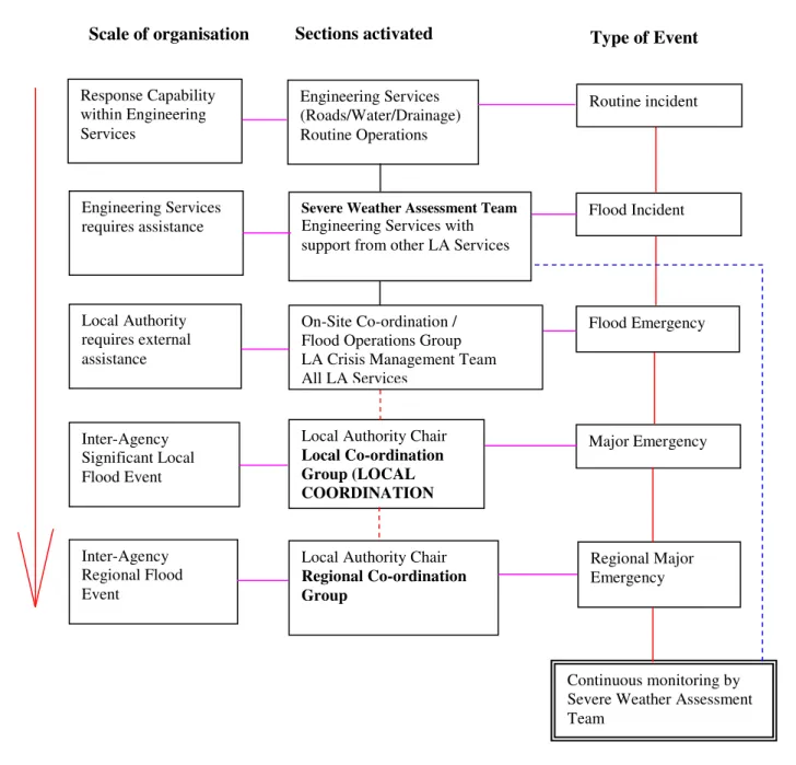
Escalation of a Flood Event:
Fig. 4.2 outlines the structure and procedure for escalation of the response to a flood emergency from a local response through the various stages leading to a wide scale response requirement.
Figure 4.2: Flood Event Escalation
Response Capability within Engineering Services Engineering Services requires assistance Local Authority requires external assistance Inter-Agency Significant Local Flood Event Inter-Agency Regional Flood Event Engineering Services (Roads/Water/Drainage) Routine Operations
Severe Weather Assessment Team
Engineering Services with support from other LA Services
On-Site Co-ordination / Flood Operations Group LA Crisis Management Team All LA Services
Local Authority Chair
Local Co-ordination Group (LOCAL COORDINATION
Local Authority Chair
Regional Co-ordination Group Flood Incident Flood Emergency Major Emergency Regional Major Emergency Continuous monitoring by Severe Weather Assessment Team
Routine incident
5. Public Information and the Media
Warnings to the Public:
In some situations it may be appropriate to issue flood warnings to the public. Some warnings may be required for the whole country, or a region of it. Other warnings may be required for a smaller area, such as a river catchment, in the case of very heavy rainfall. These warnings will normally be issued by Met Éireann. Alternatively, a warning may be required for a specific local area, such as a town, threatened by rising flood waters. This type of local warning will normally be provided by the local authority. The inter-agency Public Communications Plan process will be used to disseminate warnings to the public.
Information and warnings at local level will be issued through Local Radio, Principle Response Agency’s websites and social media forums. Is important that the content of any public warnings are carefully considered, with a view to optimising the response of the public, and the most appropriate means of disseminating those warnings identified. In the case of specific local areas identified as being at risk, it may be necessary or appropriate to deliver warnings using emergency vehicles and personnel such as Garda or Civil Defence vehicles.
A model of the colour coded system shown in Fig. 4.1 (p.R19) for response action levels will be used to determine the level of warning to be issued to the public based on risk assessment at any particular time in a developing flood scenario.
It should also be noted that the phenomenon of ‘monster rain’ may result in little or no warning time being available to issue warnings to the public.
6. Stand-down, Recovery and Clean-up Operations
Stand-down:
In many scenarios the response phase of an emergency can be short in duration. The decision to stand-down the response phase to a flooding emergency will be taken by the Local Authority Crisis Management Team in consultation with its own engineering and response staff and its partner Principle Response Agencies. This decision will be based on the effective management of the flood scenario, the beneficial impact of continuing the response phase, any threats to life and property and changing patterns in hazard and risk assessments.
Transition from Response to Recovery:
As the response phase draws towards a conclusion the Local Coordination Group or Crisis Management Team will begin to plan for the recovery phase which may include some or all of the following considerations:
• Clean-up operations, removal & disposal of debris
• Providing advice, support and assistance to the community
• Move from short term rest centres to allocation of more permanent
accommodation for persons displaced by the event
• Actions to facilitate the return of displaced persons to their homes • Continued provision of short term facilities for evacuees and persons
displaced by the event
• Procedures for clean up to facilitate insurance claims investigations
where necessary.
• Accounting for costs incurred by the responding agencies • Facilitating the provision of humanitarian assistance
Recovery:
The duration of the recovery phase can vary from a short period of time to many months depending on the scale and severity of the flood event. The initial recovery phase will include damage assessment, immediate social and economic circumstances and returning normal support systems including essential services to minimum operating standards.
Longer term recovery will seek to address the enduring human, physical, environmental, social and economic consequences of emergencies. Recovery will not just be a matter for the statutory agencies; the private sector and the community itself will play a crucial role.
A comprehensive assessment of damage and financial implications will be undertaken by agencies affected by the flood including the Local Authority on
infrastructure (roads, bridges etc.), utility companies e.g. electricity, gas, telecoms, water and waste water services and by insurance companies.
Clean-up Operations:
There are many facets to clean-up operations following a flooding emergency which can involve the Local Authority, private sector companies, insurance companies and the affected community. Where the Local Authority is not directly involved in disposal of waste and debris, private companies and individuals must do so in an appropriate manner and to an approved facility. The Local Authority may give guidance on this.
Humanitarian Aid:
A number of agencies and organisations may be involved in the collection and distribution of humanitarian aid. This may involve state agencies such as the Department of Social, Community and Family Affairs, the HSE, the Local Authority, voluntary agencies such as the Irish Red Cross and self help community groups. It will be imperative that this aspect of the recovery phase is structured and well coordinated to ensure aid is directed in a timely and appropriate manner and reaches those who are deemed to be in most need.
To this end the State or the Local Coordination Group may decide which agency is best equipped or the most appropriate to administer aid ensuring that transparency and accountability is maintained.
Report:
The Local Authority will submit interim reports to the Department of Environment, Community and Local Government as appropriate depending of the scale and impact of any emergency.
At the conclusion of the incident a de-brief will be held with the agencies involved in the response and recovery. Interested parties including those affected by the incident may be invited to submit comments for consideration and inclusion in the final report.
Appendices
Appendix Page
1 Glossary of Terms & Acronyms 22
2 Sample Flood Assessment Record Sheet 25
3 Contact Officer Details 26
1. Glossary of Terms and Acronyms
Crisis Management TeamA strategic level management group, which consists of senior managers from within the Principal Response Agency, which is assembled to manage a crisis and deal with issues arising for the agency both during the emergency and the subsequent recovery phase.
Danger Area
Area where there is a definite risk to rescue personnel, over and above that which would normally pertain at emergency operations.
Debris
The scattered remains of assets broken or destroyed in a hazard event. Debris caused by a wind or water hazard event can cause additional damage to other assets.
Evacuation
The process whereby people are directed away from an area where there is danger, whether immediate or anticipated.
Flood Action Plan – Site-specific response plan for high-risk flooding areas. These locations shall be identified and prioritised with reference to the National Preliminary Flood Risk Assessment and CFRAM Programme and in consultation with the OPW.
Flood Depth
Height of the floodwater surface above the ground surface.
Flood Hazard Area
The area shown to be inundated by a flood of a given magnitude on a map.
Flood Risk Zone
A geographical area shown on a map that reflects the severity or type of flooding in the area.
Flood plain
Any land area, including watercourse, susceptible to partial or complete inundation by water from any source.
Infrastructure
Refers to the public services of a community that have a direct impact on the quality of life. Infrastructure includes communication technology such as phone lines or Internet access, vital services such as public water supplies, sewer treatment facilities, power and gas supplies, and includes an area's transportation system such as airports, heliports, highways, bridges, tunnels, roadbeds, overpasses, railways, bridges, rail yards, depots; and waterways, canals, locks, seaports, ferries, harbours, dry-docks, piers, and regional dams
Lead Agency
The Principal Response Agency that is assigned the responsibility and mandate for the coordination function.
Local Coordination Centre
A pre-nominated building, typically at county or sub-county level, with support arrangements in place, and used for meetings of the Local Co-ordination Group.
Local Coordination Group
A group of senior representatives from the three Principal Response Agencies (An Garda Siochána, HSE and Local Authority) whose function is to facilitate strategic level co-ordination, make policy decisions, liaise with regional/national level coordination centres, if appropriate, and facilitate the distribution of information to the media and the public.
On-Site Co-ordinator (or Flood Operations Manager)
The person from the Lead Agency with the role of co-ordinating the activities of all agencies responding to an emergency at the site(s)
On-Site Co-ordination Group (or Flood Operations Group)
Group that includes the On-Site Co-ordinator (or Flood Manager) and the Controllers of Operations of the other two agencies, an Information Management Officer, a Media Liaison Officer and others as appropriate.
On-Site Co-ordination Centre
Specific area/facility at the Site Control Point where the On-Site Co-ordinator is located and the On-Site Co- ordination Group (or Flood Operations Committee) meet.
The On-Site Co-ordination Centre(s) will be established close to the incident scene.
Principal Response Agency
The agencies designated by the Government to respond to Major Emergencies i.e. An Garda Síochána, the Health Service Executive and the County Council.
Regional Co-ordination Centre
A pre-nominated building, typically at regional level, with support arrangements in place and used by the Regional Co-ordination Group.
Regional Co-ordination Group
A group of senior representatives of all relevant principal response agencies, whose function is to facilitate strategic level co-ordination at regional level.
Severe Weather Assessment Team
Experts from the County Council who are involved in monitoring and analyzing data relating to weather and hydrological information in order to provide information on the potential and scope of flood conditions. The Severe Weather Assessment Team will usually include senior operational personnel who have experience in flood emergency response or flood risk management and who have training on any flood forecast system that is in place.
ACRONYMS
AFA Area of further assessment
AGS An Garda Siochána
CFRAM Catchment Flood Risk Assessment and
Management
CMT Crisis Management Team
CO. CO. County Council
DECLG Department of the Environment, Community &
Local Government
EFAS European Flood Awareness System
ETHANE Exact Location of the emergency
Type of Flooding (Pluvial, Fluvial, Coastal etc)
Hazards, present and potential
Access/egress routes that may be affected
Number and Types of Casualties
Emergency services present and required
EU European Union
FAP Flood Action Plan
FEP Flood Emergency Plan
HSE Health Service Executive
ICG Irish Coastguard
LA Local Authority
LCC Local Co-ordination Centre
LCG Local Co-ordination Group
MEP Major Emergency Plan
MEM Major Emergency Management
NCG National Co-ordination Group
NECC National Emergency Co-ordination Centre
OPW Office of Public Works
OSC On-Site Co-ordinator
OSCC On-Site Co-ordination Centre
OSCG On-Site Co-ordination Group
OSCO On-Site Controller of Operations
PDF Permanent Defence Forces
PES Principal Emergency Services
PFRA Preliminary Flood Risk Assessment
PID Project Implementation Document
PRA Principal Response Agency
SOG Standard Operating Guideline
SOP Standard Operating Procedure
SWAT Severe Weather Assessment Team
VIP Very Important Person
WFD Water Framework Directive
2. Sample Flood Assessment Record Sheet
Flood Assessment Record
This assessment sheet is to be filled out by the group assessing any specific weather warning or flood risk, either in response to an early warning or during a flood incident.
DATE TIME 24 hr clock
ATTENDESS INPUT
INFORMATION
Met Éireann weather warning, output from flood warning system, OPW Storm Surge Data, notifications from ESB etc.
HAZARD ASSESSMENT Tick box(es) Flood Clear (Level 1) Flood Alert (Level 2) Flood Warning (Level 3) Severe Flood Warning (Level 4) Coastal Fluvial Pluvial Infrastructure Dam spilling ACTIONS INFORM D ra in ag e O p er at io n s C M T C o rp o ra te S er v ic es F ir e S er v ic e C iv il D ef O th er L A D ep ts . O th er L A 's D E C L G O P W A G S H S E C o as tg u ar d D ef en ce F o rc es E S B P o rt W at er w ay s Ir el an d O th er Tick boxes MOBILISE D ra in ag e O p er at io n s C M T C o rp o ra te S er v ic es F ir e S er v ic e C iv il D ef O th er L A D ep ts . O th er L A ’s D E C L G O P W A G S H S E C o as tg u ar d D ef en ce F o rc es E S B P o rt W at er w ay s Ir el an d O th er Tick boxes
MONITOR BY SWAT Drainage CMT
Tick box
DEPLOY DEFENCES
Flood Gates Demountable Defences
Sand Bags
Tick boxes
COMMENTS
NEXT REVIEW Time Location (or Conf Call) Attendees
Fill in details
7. Other Weather Events
Severe Frost / Heavy Snow:
Meath County Council operates a road network Winter Maintenance Programme in accordance with DECLG circular guidelines. This programme operates between November 1st and April 30th each year.
Meath County Council has a fleet of ten trucks equipped to carry gritters and snow ploughs. All of these vehicles operate on pre-determined routes (attached). The gritting programme covers a total of 460 km of the road network on each occasion.
The rostered engineer has access to the national “Ice Cast” software system. Each day during the prescribed dates the duty engineer accesses the server usually between 14.30 hrs. and 15.00 hrs. to receive a detailed up to date local weather forecast. This allows time to load the gritters and if necessary the snow ploughs before normal close of business.
In the event of heavy snow arrangements are in place with local contractors to supplement the County Council snow ploughs with earth moving machinery,
Winter Gritting Routes
Route Roads Covered
A
Start gritting at the Longwood rd. Roundabout in Trim (include roundabout) and grit to the Garda station in Longwood. Stop gritting, turn round and drive back to junction at start of village and grit from there, past the sewage works to junction with R148. Stop gritting and drive to roundabout just before Kinnegad. Grit roundabout and continue gritting R148 to junction with Rathmolyon rd. Grit roundabout. Stop gritting and travel to Kilcock, turn left in village to Summerhill rd. and grit from bridge (Meath border) through Summerhill to roundabout in Trim.
B
Start gritting at traffic lights at Navan rd. junction on Trim ring rd. to roundabout at Summerhill rd. (roundabouts included.) then back to Dublin rd. roundabout and grit R154 to Blackbull/N3 junction. Stop gritting and travel to N3 roundabout for Dunboyne. Grit from through each roundabout (include roundabouts) to junction with R157 Dunboyne-Maynooth road and stop gritting. Turn left and proceed to Dunboyne village. Grit through village, across Boylan's bridge to Mushroom roundabout. Stop gritting and return to lights in village. Grit from there on R157 to Kildare border at Maynooth. Stop gritting and return to Dunboyne and grit R156 from lights through Summerhill, Rathmolyon to junction with Longwood/Trim rd. (R160).
C
Start gritting at the Old Bridge Inn at Kilcarn on the N3 in Navan and grit to the first street light on the Clonee dual carriageway. Stop gritting and travel to the first exit and grit the slip road and continue gritting round the roundabout, turn right and grit across the dual carriageway to the roundabout on the other side, turn left and grit through Clonee village to the traffic lights , and turn left over the dual carriageway again. Turn left at the first junction and continue gritting past Kepak to the roundabout, turn left again, back across the dual carriageway to the roundabout on the other side and this time turn right and grit to the junction with the N3. Stop gritting and drive to Fairyhouse cross. Grit from there to Ratoath village, turn right in the village and continue gritting towards Ashbourne. Take the last right turn before the Nine Mile Stone and grit the bridge across the motorway at Baltrasna. Turn around and drive back to the R125. Turn right and continue gritting to the Nine Mile Stone junction at the N2. Stop gritting and turn left, travel through Ashbourne to Primatestown.
Grit from the junction turning left through Curraha to Ratoath. Grit across the staggered cross in Ratoath and turn right at the new Supermarket and continue gritting to the N3 in Dunshaughlin. Stop gritting and turn right for Navan. Travel to the junction of the R125 with the N3 at new Dunshaughlin water tower. Turn left and grit from there across the M3 to the junction with the R154 near Batterstown, including all roundabouts. Return to the N3 and travel to Navan. Drive to the traffic lights at Kilcarne, turn right and grit from there to the roundabout at Johnstown, turn left and grit to traffic lights at N3 (opposite Ardboyne Hotel).
Route Roads Covered
D
Start gritting at the traffic lights at the square in Slane and grit from there to the Meath/Louth border on the N2. Stop gritting and go back to the square in Slane and grit from there to the Meath/Louth border on the N51 (Slane/Drogheda rd.) at Rossin. Stop gritting and drive to the Meath/Louth border on the R132 (old N1) at the Boyne Valley Hotel on the Dublin rd. in Drogheda. Grit from there on the R132 (old N1) to the Meath/Dublin border at Delvin Bridge at Gormanstown. Stop gritting and drive back on the R132 to Drogheda and start gritting at the Metal Bridge on the Drogheda/Duleek rd. and grit to the N2 at Kilmoon Cross. Stop gritting and drive to Curtis's Cross on the N2.Turn right and start gritting from there, through Duleek to the graveyard in Duleek.
E
Start gritting at Poolboy Bridge in Navan and grit up Flower Hill to the Round "O" pub and on to the square in Slane village. Turn right at the square in Slane and continue gritting on the N2 South to the Meath/Dublin boundary at Coolquay. Stop gritting, turn around and drive back to the Nine Mile Stone junction south of Ashbourne. Turn right and grit from there to the Meath/Dublin boundary on that road. Stop gritting, turn around and drive to Balrath Cross on the N2, turn left and grit from there to the Chapel in Kentstown village. Turn sharp right and continue gritting out to Flemington Cross on the N2.Stop gritting, turn around and drive back to Kentstown Chapel and grit from there to the junction at Athlumney (Mace Supermarket on left), turn left and continue gritting to the roundabout. Grit around the roundabout, stop gritting, drive back to the junction with the Navan/Kentstown Rd. and grit from there to the Meath Chronicle junction in Navan.
F
Start gritting at Westmeath border on N52 and grit to the Railway yard in Kells. Stop gritting and drive to Kerr's garage in Athboy. Grit from there to traffic lights at Navan rd. junction in Trim. Turn left for Navan and continue gritting to the roundabout at the Mercy convent in Railway st. Navan. Stop gritting and drive back to Beechmount Filling Station on Trim/Navan rd., turn right and grit from there to junction with Common's rd. turn left and continue gritting on Common's rd. to Common's lane. Stop gritting, turn and drive to Hospital gates on Navan/Athboy rd. and grit from there through Athboy to Westmeath border.
G
Start gritting at the Junction of the R164/N51 near Athboy, grit from there to Kells along and stop gritting at the Railway Bar (R164/N52 Junction). Begin again at junction of Circular rd (R154/N52) and grit to Oldcastle (R154) and on out the Mount Nugent rd (R154) to the county boundary. Return to Oldcastle and grit the R195 Castlepollard road to County Boundary. Return to Oldcastle and grit on out the Virginia rd (R195).
H
Start gritting at Motor Factor's in Kells (junction of N3/N52) and grit from there to Cassidy's garage at junction with Navan/Nobber rd. and straight through Woodtown to the Louth border. Stop gritting and drive to the chapel in Castletown village and grit from there to the Monument cross on the Navan/Nobber rd., turn right and grit to the Cavan border at Kingscourt. Stop gritting, turn and drive back to the Monument cross and grit from there to the Round O pub in Navan and on to the Fire Station.
Route Roads Covered
I
Begin gritting at the junction just before Skryne school. Grit from there to the entrance to the new housing estate on the right at the bottom of the hill. Stop gritting and drive to Ratoath. Approach Ashbourne on the Ballybin Road and start gritting just before the motorway bridge. Continue gritting to the junction with the N2. Stop gritting, turn right, travel through Ashbourne to Newtown. Turn right and grit the bridge over the motorway at Newtown Commons. Continue to T-junction, turn right and grit the Wooton Bridge across the Motorway and back to the N2. Stop gritting, turn left and drive through Ashbourne to the Rath roundabout. Grit the slip road and continue gritting Southbound on the motorway to a point south of the Cherryhound interchange where the slip roads have re-joined the carriageway. Stop gritting and drive to the M50 interchange. Drive round the roundabout and re-join the M2 Northbound. Start gritting again at the same point where you stopped gritting on the Southbound carriageway (beginning of slip road to Cherryhound interchange).
Continue gritting to the Rath roundabout, grit around the roundabout itself twice (to ensure you cover everything). Stop gritting and drive South on M2 again to the slip road signed ‘Ashbourne/Ratoath/Swords’. Take this exit, start gritting and grit to the Nine Mile Stone roundabout, including the roundabout itself twice. Take the motorway exit off the roundabout, staying in the right-hand lane, crossing the motorway overbridge, completing the loop to re-join the motorway North-bound and stop gritting. Drive to the Rath roundabout and back South-bound on the motorway. Again take the ‘Ashbourne/Ratoath/Swords’ exit. Drive around the Nine Mile Stone roundabout and approach the motorway again, this time staying in the left-hand lane, gritting the slip road until it re-joins the motorway proper. Continue driving to the Cherryhound exit (‘St. Margarets/Blanchardstown’). Grit the Cherryhound roundabout exiting at the ‘Derry/Ashbourne’ exit. Grit until you rejoins the motorway proper. Continue along the motorway to the ‘Ashbourne/Ratoath/Swords’ exit. Grit the slip road and across the motorway to the Nine Mile Stone roundabout. Stop gritting and return to base.
J
Begin gritting at the Interchange of M3 at Kennastown and grit back to new roundabout at Kilcarn on the R147 (old N3). Grit from there to the roundabout on the R147 south of Kells at Kilmainham. Grit from the roundabout to the Interchange of the M3 at Cookstown Great. Loop around and return to the roundabout at Kilmainham and continue along the R147 through Kells to the county boundary with Cavan. Stop and return by gritting the New N3 to it junction with the N52. Grit the roundabouts at the N52 Interchange west of Kells and from there grit the N52 Kells Bypass to its east end at the roundabout at Cakestown Glebe.
Storm Winds:
In the event of storm winds causing fallen trees or structural damage, the health and safety of County Council staff will be a determining factor in deciding when clearance and clean up operations can take place.
In the event of fallen trees obstructing roads, County Council staff from the affected area will clear the obstruction if it is safe to do so. If it is deemed unsafe “Road Blocked” signs will be put in place in conjunction with the Gardai until it is safe to carry out the work. Similar arrangements will operate in other situations where Health & Safety of staff is an issue. When the County Council becomes aware of the existence of trees along the road
network which are considered to be in a dangerous condition, a tree felling notice will be served on the landowner.
Heat Wave:
Ireland records temperatures above 30 degrees about once every ten years. Effects of a prolonged heat wave will include water shortages and health care issues particularly for the elderly, young children and those suffering from specific illnesses.
Meath County Council will implement a series of water conservation measures if necessary including water rationing and hose pipe bans. The County Council will provide assistance to the Health Service Executive if required principally through Meath Civil Defence services.
Management of Severe Weather Events:
In most severe weather events, advanced warnings will be issued to the County Council through the Met Eireann forecasting arrangements. When a severe weather event is imminent and is likely to disrupt normal functioning, the County Manager or nominated Director of Service will convene an appropriate crisis management group either directly or through teleconferencing facilities to assess the likely impact and state of readiness of the County Council to deal with the impending scenario. Where a severe weather event is protracted an expanded crisis management team comprising senior management, senior engineers, area engineers, media liaison officer, fire officers and Civil Defence Officer will meet on a regular basis either face to face or through teleconferencing facilities to manage the County Council’s response.
Protocol for the Management of Severe Weather Events:
On receipt of a Severe Weather alert which may warrant mitigating actions the Emergency Planning Officer or designated alternate will initiate the following actions:
Consult with some or all of the following:
• DoS Environment, Water & Emergency Services • DoS Transportation
• Senior Engineer Environment • Senior Engineer Transportation • Chief Fire Officer
• Duty Engineer “Ice-cast” • Area Engineers
If deemed appropriate following consultation:
• Arrange teleconference to include all of the above and • Co. Manager
• DoS Corporate Services • DoS Housing
• Head of Finance • Media Liaison Officer • SEO Corporate Services
• Other staff as deemed necessary for the particular incident
Agree actions to be taken and time frame for any follow up meetings or teleconference.