The response of the Gulf of Mexico to wind and heat flux forcing: What has
been learned in recent years?
JORGE ZAVALA-HIDALGO, ROSARIO ROMERO-CENTENO and ADRIANA MATEOS-JASSO
Centro de Ciencias de la Atmósfera, Universidad Nacional Autónoma de México, Circuito de la Investigación Científica s/n, Ciudad Universitaria, 04510 México, D.F.
Corresponding author: J. Zavala-Hidalgo; e-mail: [email protected]
STEVEN L. MOREY
Center for Ocean-Atmospheric Prediction Studies, Florida State University, 2000 Levy Avenue, Building A, Suite 292, Tallahassee, FL 32306-2741, USA
BENJAMÍN MARTÍNEZ-LÓPEZ
Centro de Ciencias de la Atmósfera, Universidad Nacional Autónoma de México, Circuito de la Investigación Científica s/n, Ciudad Universitaria, 04510 México, D.F.
Received December 9, 2013; accepted June 2, 2014
RESUMEN
La dinámica del Golfo de México (GoM) se asocia frecuentemente con la Corriente del Lazo y los remolinos que se desprenden de ésta, los cuales son altamente energéticos y ocasionan corrientes intensas que pueden penetrar varios cientos de metros en la columna de agua. Sin embargo, hay regiones en el GoM y periodos de tiempo en que el forzamiento atmosférico local juega un papel importante en su dinámica y termodinámica. La circulación en las plataformas, particularmente en la interna, es generada principalmente por viento y tiene estacionalidad, ya que cambia de dirección a lo largo del año y tiene algunos periodos de condiciones favorables para el afloramiento/hundimiento. La circulación generada por el viento se vincula con el trans-porte de aguas con diferentes características de temperatura y salinidad. La variabilidad interanual de la circulación en las plataformas está asociada con la variabilidad interanual de la circulación atmosférica. Se ha identificado que la variabilidad intraestacional de los patrones de viento modifica considerablemente la ocurrencia de afloramientos y hundimientos. Debido a la forma y tamaño del GoM, cuando la circulación en una plataforma ocurre en sentido horario, puede darse en sentido opuesto en otras plataformas. El ancho de las plataformas en el GoM es variable: la plataforma oeste de Florida, la de Texas-Louisiana y el Banco de Campeche miden más de 200 km, en tanto que las más angostas son las de Veracruz y Tabasco. Otra conse-cuencia de la fisiografía del GoM y el forzamiento del viento es el desarrollo de transportes perpendiculares a la plataforma en el sur de la Bahía de Campeche, el sur de la plataforma de Texas y al sureste del Mississippi, los cuales a su vez varían a lo largo del año. El GoM es afectado durante el otoño-invierno (desde septiembre hasta abril) por frentes fríos provenientes del noroeste de Estados Unidos, los cuales tienen asociados vientos fuertes, secos y fríos que mezclan sus aguas y generan intensos flujos de calor sensible y latente del mar hacia la atmósfera. Estos vientos también enfrían el GoM debido a la mezcla de aguas cálidas de la superficie con aguas subsuperficiales de menor temperatura. Durante el verano, los ciclones tropicales que cruzan el GoM afectan su circulación y los afloramientos costeros.
ABSTRACT
atmospheric forcing plays an important role in its dynamics and thermodynamics. The circulation on the shelves, and particularly on the inner shelf, is mainly wind-driven with seasonality, changing direction during the year with periods of favorable upwelling/downwelling conditions. The wind-driven circulation is asso-ciated with the transport of waters with different temperature and salinity characteristics from one region to another. The interannual variability of the circulation on the shelves is linked to the atmospheric variability. Intraseasonal variability of the wind patterns considerably affects the likelihood and magnitude of upwelling and downwelling. The geometry of the GoM is such that large-scale winds may drive opposing upcoast/ downcoast currents along different parts of the curving coast, resulting in convergence or divergence zones. The width of the shelves in the GoM is variable;while the West Florida Shelf, the Texas-Louisiana shelf and the Campeche Bank are more than 200 km wide, they are narrower near Veracruz and Tabasco. Another consequence of the GoM physiography and the wind forcing is the development of cross-shelf transports in the southern Bay of Campeche, the southern Texas shelf and southeast of the Mississippi river, which in turn vary during the year. During autumn-winter (from September to April), the GoM is affected by cold fronts coming from the northwest United States, which are associated with strong, dry, and cold winds that mix its waters and generate large sensible and latent heat fluxes from the ocean to the atmosphere. These frontal passages also cool the GoM surface waters due to mixing with lower temperature subsurface waters. During summer, tropical cyclones crossing the GoM can dramatically affect circulation and coastal upwelling.
Keywords: Gulf of Mexico, ocean surface forcing, upper ocean layer.
1. Introduction
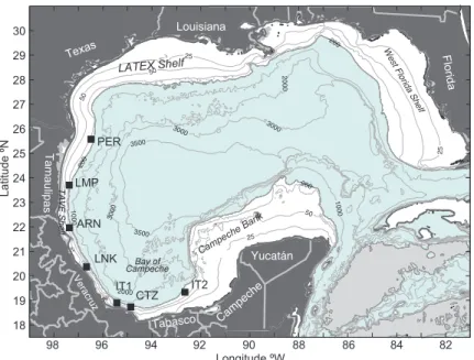
The Gulf of Mexico (GoM) is a semienclosed sea with deep areas and narrow as well as wide conti-nental shelves (Fig. 1). The GoM has been the object of many studies, so it is important to periodically review and synthesize recent results and to identify knowledge gaps, warranting investigation in the near future. The purpose of this manuscript is to review
what has been learned in recent years related to the local surface forcing of the GoM, both by heat fluxes and wind stress. Some historic publications have re-viewed general aspects of the GoM and others have been more topically focused. Examples of these review publications are the very ambitious and successful
Fishery Bulletin 89 (Galtsoff, 1954) that summarizes the knowledge on the Gulf at that time, including
25
25
2000 3500
3000
20
00
200
50
200
10 00 3000
1000 200 3000
Campeche Bank
LATEX Shelf
TAVE Shelf
Bay of Campeche
W est Florida Shel
f
Yucatán
Campeche
Tabasco
Ve racruz Tamaulipas
Texas
Louisiana
Florida
50
3500
50
25
98 96 94 92
Longitude ºW
Latitude ºN
90 88 86 84 82
18 19 20 21 22 23 24 25 26 27 28 29 30
ARN LMP
PER
LNK
IT1
CTZ IT2
information of its marine meteorology, geological features, the physics and chemistry of its waters, its physical oceanography, and a detailed review of its biology. Another classical document is a book edited
by Capurro and Reid (1972), which includes chapters
related to the physical phenomena affecting the GoM that were studied at that time. Recently, the American Geophysical Union published a monograph (Sturges and Lugo-Fernández, 2005), which includes articles on the current knowledge of the Gulf in selected topics. Recent events, like the Deep Water Horizon oil spill of 2010, opened discussion on several aspects of the GoM dynamics, like the influence of the wind on the oil spill advection and dispersion, the trans-port from deep-water to coastal areas, the role of wind waves in the mixing and dispersion of the oil, the mixed layer dynamics, etc., which brought
re-newed attention to these ocean processes (Liu et al.,
2011). Perhaps bolstered by this event, substantial work has been undertaken on a new generation of very high resolution numerical models used to simu-late biogeochemical and biological processes, which are strongly influenced by the ocean-atmosphere interaction. The present work summarizes recent advances in understanding the influence of heat and momentum fluxes (wind stress) on the GoM dynamics and thermodynamics. The annual cycle of heat fluxes and winds is described, emphasizing the response of the mixed layer depth, sea surface temperature (SST), and entrainment. The influence of the wind stress and wind stress curl on the circula-tion of the GoM, particularly on the shelves, coastal upwelling and cross-shelf transports, including the seasonality and interannual variability (in some cases), are also described.
2. The winds in the Gulf of Mexico
Although the low level winds over the GoM are very important for the ocean circulation, surface fluxes, mixed layer properties, and generation of wind waves, there are relatively few studies about
them (e.g., DiMego et al., 1976; Gutiérrez and
Winant, 1996; Wang et al., 1998). However, several
other studies have analyzed specific aspects of the winds over the GoM that are related with particular
ocean processes (e.g. Oey, 1995; Zavala-Hidalgo et
al., 2003; Morey et al., 2005; Nowlin et al., 2005;
Vázquez de la Cerda et al., 2005; Martínez-López and
Zavala-Hidalgo, 2009; Dubranna et al., 2011;
Ma-teos-Jasso et al., 2012; Pérez-Brunius et al., 2013).
Here, a general description of the characteristics of the wind and surface fluxes in the GoM is presented, and other aspects that need to be analyzed or updated are suggested.
2.1 Seasonal variability of the winds
The winds in the GoM have strong variability over different time and space scales, with important seasonality. The GoM is affected by intense winds caused by tropical cyclones that cross it between May and November and by cold fronts reaching the area mainly between September and May. Winds that are not associated with these strong events are weaker, but are important for upwelling, mixed layer depth, surface fluxes, circulation (particularly on the shelves), development of wind waves, etc.
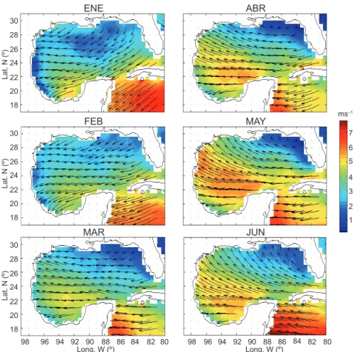
Winds over the GoM are part of the trade winds and have a large influence on the North American continent. Based on long-term monthly means com-puted from the QuikSCAT/SeaWinds scatterometer data, it is observed that, during summer, the wind turns toward the north in the northwestern Gulf due to the influence of the North Atlantic semi-perma-nent atmospheric high-pressure system over the northeastern region (Fig. 2). This pattern is probably reinforced by the high temperature over land driv-ing a monsoonal effect. Between May and August, winds are more intense in the western Gulf and are weaker in the northeast, with this pattern more evi-dent in July (Fig. 2). In September, this wind pattern changes because the cold fronts associated with atmospheric high-pressure systems coming from the northwestern United States begin to reach the GoM and the semi-permanent high-pressure system over the Atlantic Ocean shifts northeastward. During autumn, the long-term monthly mean wind direction in the northern Gulf is mainly westward, with a small southward component. In the Bay of Campeche an intense southward wind component develops, mainly in the western side of the bay, favored by a mountain blocking effect caused by the Sierra Madre Oriental in Mexico that directs the wind through the Isthmus of Tehuantepec where the mountain chain has a low altitude passage. In addition, the lower pressure in the Gulf of Tehuantepec also favors southward
winds (Romero-Centeno et al., 2003). This pattern
The time-mean wind stress curl is negative (an-ticyclonic) north of 23 ºN and positive (cyclonic) south of that latitude, mainly in the Campeche Bay. The zero wind stress curl contour line has a south-east-northwest orientation (Gutiérrez de Velasco and Winant, 1996, their Figs. 5-8). The annual cycle of the wind stress curl is characterized by the displace-ment of the zero contour line, moving southward during spring and summer and northward in autumn and winter. The largest negative values of the wind stress curl are observed in the northeastern GoM in summer and they became smaller in winter. During autumn and winter, positive values are larger in the western Bay of Campeche (Gutiérrez de Velasco and Winant, 1996, their Figs. 5-8).
2.2 High frequency winds
Every year several easterly waves are generated over west Africa and the eastern tropical Atlantic. These perturbations travel from east to west as Rossby
waves, with wavelengths of about 2000 to 5000 km
and phase speed between 8 and 12 ms–1. In some
cases, these waves develop into tropical storms or
hurricanes (Burphee, 1974; Diedhiou et al., 1999), but
not all the tropical cyclones are generated by easterly waves. In the tropical North Atlantic basin there is an annual cumulative average of 11.3 named systems of which 6.2 are hurricanes (www.nhc.noaa.gov). Not all the easterly waves reach the GoM because, in many cases, they turn northeastward crossing the major Caribbean Islands or turn even before the Caribbean Sea. When easterly waves reach the GoM they affect the stratification and shelf circulation, because they produce changes in the direction and
intensity of the winds (Mateos-Jasso et al., 2012).
The cold fronts, or northers, can occur all year
round in the GoM but with different intensity, frequency, and southward penetration. They have associated strong northerly winds and cold and dry air masses. During summer they are very rare, while 30
7 ms–1
6 5 4 3 2 1 ENE
FEB
ABR
MAY
MAR JUN
28 26
Lat. N (º
)
24 22 20 18
30 28 26
Lat. N (º
)
24 22 20 18
30 28 26
Lat. N (º
)
24 22 20 18
98 96 94 92 90
Long. W (º)88 86 84 82 80 98 96 94 92 90Long. W (º)88 86 84 82 80
Fig. 2. Long-term monthly means (1999-2006) of the winds in the Gulf of Mexico based on Qscat/SeaWinds data. Contours indicate the scalar mean wind speed (ms–1)
in autumn-winter are more frequent. The transition between these two seasons occurs in late September and is very sharp. These strong fronts can continue to occur until spring, but diminishing in numbers and
in-tensity through April and May (DiMego et al., 1976).
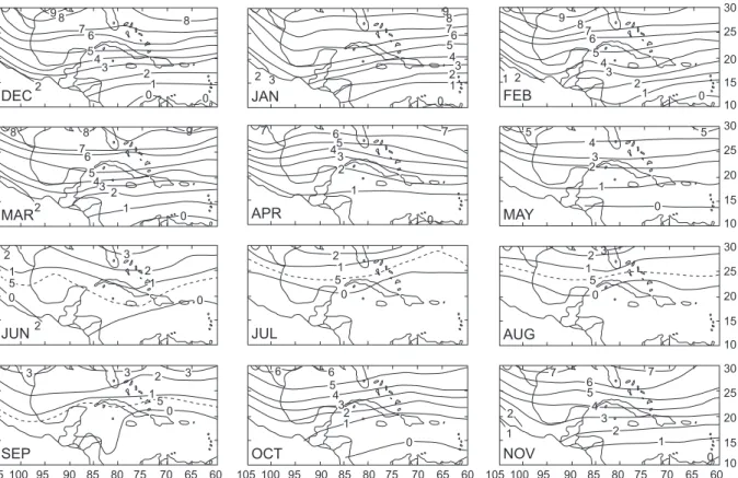
Not all the fronts cross the whole GoM; most of them only reach the northern part. The duration of the strong winds and cold air associated with the passage of fronts also decreases southward. Therefore, the number of observed fronts per year and their duration depends on the region of the GoM (Fig. 3) (DiMego
et al.,1976). Another characteristic of the northers
is the occurrence during autumn, in some years, of long periods of continuous northerly winds offshore
of Veracruz (Mateos-Jasso et al., 2012) (Fig. 4).
These long events were not observed in the winter
months, although the study of Mateos-Jasso et al.
(2012) covers few years.
Before the arrival of a cold front, southeasterly winds are observed, associated with high moisture content, high temperatures and low atmospheric
pressure. Once the front crosses a given location, the wind intensifies and changes its direction, the atmo-spheric pressure increases, and the temperature drops
(DiMego et al., 1976). Frequently, during the frontal
passage, heavy precipitation occurs (López-Méndez, 2009).
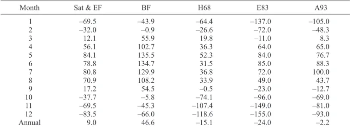
3. Heat fluxes
The SST of the GoM has a large amplitude annual cycle, with a considerable spatial variability. This was the object of study in the 1980s, 1990s, and early 2000s, but recently there has not been an update based on new available data and high resolution models. The goal of an update should be to have smaller un-certainties on the assessment of the contribution of each term in the heat balance equation (Eq. 1). Some early studies estimated the value of one or several terms of the heat content equation for the GoM
(Has-tenrath, 1968; Etter, 1983; Etter et al., 1987; Adem
et al., 1993; Zavala-Hidalgo et al., 2002), which can be represented as follows:
30
7 6 5 4 3 2 1 JUL
AGO
OCT
NOV
SEP DIC
28 26
Lat. N (º
)
24 22 20 18
30 28 26
Lat. N (º
)
24 22 20 18
30 28 26
Lat. N (º
)
24 22 20 18
98 96 94 92 90
Long. W (º)88 86 84 82 80 98 96 94 92 90Long. W (º)88 86 84 82 80 ms–1
∂H / ∂t = Qs+ Qb+ Qe+ Qh+ Qa (1)
where
H = ρC
∫
p(T – Tref)dz (2)is the total heat energy, ρ is the density and Cp is the
specific heat of sea water, T is the temperature, and
Tref is a reference temperature so that H values are
relative to it. Qs, Qb, Qe, and Qh are the net short wave
radiation into the ocean, the heat emitted by the ocean as long wave radiation (including the atmospheric feedback due to the greenhouse effect), the latent heat flux due to evaporation, and the sensible heat, respectively (in this case all terms are positive when
the ocean gains heat, so usually Qbis negative). The
term Qa is the lateral heat advection. Heat content
has been estimated based on hydrographic data (Et-ter, 1983), empirical formulae and, in some cases, considering the temperature and fluxes through the Yucatan Channel (Hastenrath, 1968; Hastenrath and
Lamb, 1978; Etter, 1983; Adem et al., 1993). These
estimations have shown that the GoM gains heat
from March or April to August or September, with the peak of heat gain between May and July. The net surface heat flux over the whole year is estimated to
vary between –24 Wm–2 and 46.6 Wm–2 (Table I).
Differences are due to the different methodologies used in those studies, e.g. different turbulent coef-ficients on the bulk formulae, short wave radiation formulations, cloud cover, wind speed, and the con-sideration or not of entrainment (see Zavala-Hidalgo
et al., 2002 for a detailed discussion of each term). Heat fluxes associated with individual synoptic scale
events, such as northers, may be very large, as
dis-cussed by Nowlin and Parker (1974), Villanueva et
al. (2010), and Rudzin et al. (2013).
4. Mixed layer depth and entrainment
Zavala-Hidalgo et al. (2002), Mendoza et al. (2005),
and Villanueva et al. (2010) proposed that the
mixed layer entrainment via turbulent mixing has a significant contribution to the winter SST cooling. It was found that there is a better agreement between observations and the modeled SST when entrainment is considered. SST, mixed layer depth and
entrain-30 25 20 15 10 30 25 20 15 10 30 25 20 15 10 30 25 20 15 10 105 100 95 90 85 80 75 70 65 60 105 100 95 90 85 80 75 70 65 60 105 100 95 90 85 80 75 70 65 60
DEC2 01 0
2 3 4 5 6 7 8 8 9
JAN2 3 01
23 4 56 7 8 9
FEB2 1 0
1 43 2
5 6 7 8 9 MAY 0 1 23 4 5 5 APR 7 7 1 0 2 3 465
MAR 9 8 1 0 2 2 3 4 6 7 8 5 JUN 2 1 1 0 0 2 2 3 5 JUL 2 1 0 5 AUG 2 3 1 0 5 NOV 2
2 43
1 1 0 5 6 7 7 OCT 2 3 4 1 0 5 6 6 SEP 2 3 3 3 1 0 5
Table I. Total average surface heat fluxes in Wm–2 from different studies. Sat & EF are results from Zavala-Hidalgo
et al. (2002) considering radiation measured by satellites and empirical formulas; BF are results from Zavala-Hidalgo et al. (2002) considering bulk formulas; H68 are estimations by Hasternrath (1968); E83 are estimations by Etter (1983), and A93 are estimations by Adem et al. (1993). Table addapted from Zavala-Hidalgo et al. (2002).
Month Sat & EF BF H68 E83 A93
1 –69.5 –43.9 –64.4 –137.0 –105.0
2 –32.0 –0.9 –26.6 –72.0 –48.3
3 12.1 55.9 19.8 –11.0 8.3
4 56.1 102.7 36.3 64.0 65.0
5 84.1 135.5 52.3 84.0 76.7
6 78.8 134.7 31.5 85.0 88.3
7 80.8 129.9 36.8 72.0 100.0
8 70.9 108.2 33.9 49.0 43.7
9 17.2 54.5 –0.5 –23.0 –12.7
10 –37.7 –5.8 –74.1 –96.0 –69.0
11 –69.5 –45.3 –107.4 –149.0 –81.0
12 –83.5 –66.0 –118.6 –155.0 –93.0
Annual 9.0 46.6 –15.1 –24.0 –2.2
−6 −4 −20 2 4 6 8 10
−6 −4 −20 2 4 6 8 10
−6 −4 −20 2 4 6 8 10
−6 −4 −20 2 4 6 8 10
−6 −4 −20 2 4 6 8 10
−6 −4 −20 2 4 6 8 10
JAN FEB MAR APR MAY JUN JUL AUG SEP OCT NOV DEC
2007
2008
2009
2010
2011
2012
ms
–1
ms
–1
ms
–1
ms
–1
ms
–1
ms
–1
ment were estimated using a primitive equation nu-merical model with bulk formulas by Zavala-Hidalgo
et al. (2002), and using a model with climatological currents coupled to a Kraus-Turner type model
(Kraus and Turner, 1967) by Mendoza et al. (2005).
Both studies show similar annual cycles and values for the entrainment, with larger values between No-vember and February, and for the mixed layer depth, which is deeper in December-March and shallower in June-August (Fig. 5). In addition, it was shown that there is a strong relation between the entrainment and pigment concentration in the deep GoM (estimation of chlorophyll-a concentration), with high values during winter and low in summer (Fig. 5).
The autumn-wintertime changes of mixed layer depth and entrainment discussed above are mainly
due to the northers, through increased mixing and
cooling heat flux during autumn-winter. These pro-cesses are more intense in the northern GoM where
the lowest temperatures are observed. The impact of
a single norther on the SST and mixed layer depth
was studied by Villanueva et al. (2010). During that
event there was a larger contribution to the tempera-ture decrease by the entrainment than by the added contribution of the sensible and latent heat fluxes.
5. Shelf circulation
There are differences between the physical processes in the deep ocean and those occurring on the shelves, even considering only the near surface layer of tens of meters. The shoreline restricts the motion leading to circulation patterns that are not observed in the open ocean, in particular the coastally trapped waves, mainly barotropic, although baroclinic waves are observed along the slope. Another difference is the influence on the dynamics of rivers discharge, which induces strong density gradients by the input of fresh water that affects the water motion through buoyan-cy forces. Another major characteristic of the shelf circulation is due to the relatively low depth, which makes the bottom friction important. In addition to those characteristics of the shelves, the slope works, in some cases, as a barrier between the deep ocean and the shelf because of the conservation of poten-tial vorticity, making the ratio of along-shelf current variability to cross-shelf current variability large.
Several studies have shown that the dynamics of the shelves, particularly in the inner shelf of wide shelves, is mainly driven by the local momentum flux and the fresh river input. Over the outer shelf, deep ocean eddies and the Loop Current may have an important contribution when they impinge on the
shelf slope (Oey, 1995; Walker, 2005; Weisberg et
al., 2005; Dubranna et al., 2011). The wind stress
forcing has a seasonality in its direction and intensity, reversing the inner shelf currents along the year. The shelves in the GoM are distinguished by their behav-ior along the annual cycle, that is the case of the West Florida Shelf (WFS), the Mobile-Alabama-Florida shelf (MAFLA), the Texas-Louisiana shelf (LATEX), the Tamaulipas-Veracruz shelf (TAVE), and the Campeche Bank. Most studies have found that the inner-shelf is dominated by a wind-driven circulation with the along-coast wind stress component deter-mining the current direction (e.g. Zavala-Hidalgo
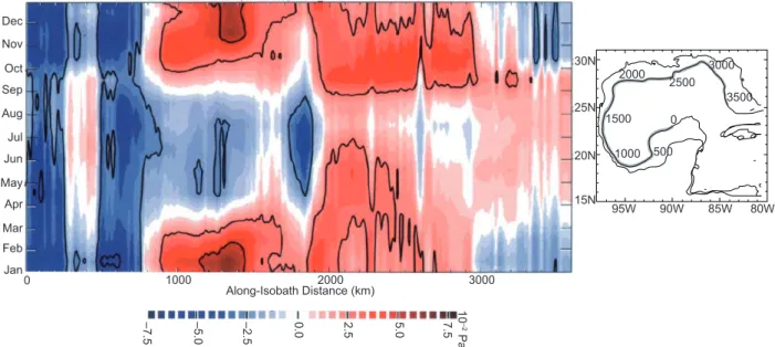
et al., 2003; Nowlin et al., 2005; Weisberg et al., 2005). Therefore, a scheme showing the monthly along-coast wind stress component has been helpful 85 80 75 70 65 60 55 50 45
Mixed layer depth (m
) 40 35 25 15 30 20 10
JAN FEB MAR APR MA
Y JU N JU L AU G SEP OC T NO V DE C
JAN FEB MAR APR MA
Y JU N JU L AU G SEP OC T NO V DE C 2.8 0.24 0.22 0.18 0.16 0.14 0.12 0.1 0.08 0.06 0.04 0.2 2.6 2.4 2.2 1.8 1.6 1.4 1.2 1 0.8 0.6 2
Entrainment velocity (1
0
–6 ms –1)
Photosyntetic pigment concentration (mg/m
3) Model
Obs
Entrainment Pigment
to understand the seasonality of the currents and other
processes (Morey et al., 2005; Zavala-Hidalgo et al.,
2006) (Fig. 6). There are regions showing a different behavior of the along-coast wind stress component and its variability along the year. The Campeche Bank has a clockwise wind stress component during the whole year; a small region offshore of the Campeche State has weak wind stress but changes between a counterclockwise direction during spring-summer to a clockwise during autumn-winter. The southernmost part of the GoM, in front of the Tabasco State, also shows a clockwise direction along the year. The re-gion between southern Veracruz to the international border at the Río Bravo (Río Grande) mouth has a counterclockwise along-coast wind stress direction between September and March and clockwise be-tween April and August. In the LATEX shelf, most of the year the wind stress component is counterclock-wise except for a small period when it reverses. The WFS has a period with clockwise along-coast winds between October and March, and counterclockwise between April and September.
The seasonal shift in the wind direction has an associated directional change in the momentum fluxes affecting mainly the inner-shelf, in particular when the along-coast wind stress component is large. Major results regarding the circulation on the shelves are presented next.
5.1 The Texas-Louisiana shelf
The circulation on the LATEX shelf has been studied intensively based on hydrographic sur-veys (Cochrane and Kelly, 1986), current meters,
meteorological buoys (Cho et al., 1998; Nowlin et
al., 1998a, b), and numerical modeling (Oey, 1995;
Zhang and Hetland, 2012). The low frequency circulation on the LATEX shelf is dominated by a wind-driven cyclonic circulation, with a strong jet over the inner-shelf and a weaker and broader northeastward current over the outer shelf. This pattern is observed most of the year, except during July and August when the alongcoast wind
compo-nent reverses (Cochrane and Kelly, 1986; Cho et al.,
1998; Wang et al., 1998; Nowlin et al., 2005). Over
the outer shelf and the shelf break, the circulation is predominantly clockwise, probably due to the impingement of decaying anticyclonic eddies on the shelf edge. During the non-summer period, the shelf shows mainly a counterclockwise (clockwise) circulation in regions where depth is shallower (deeper) than 50 m. Variability on the inner-shelf is dominated by the 2- to 10-day time scale, consistent with synoptic scale atmospheric forcing, while in the outer shelf is on the oceanic mesoscale time scale (10-100 days), suggesting that the main forcing in the outer shelf is related with the impinging eddies
on the shelf edge (Nowlin et al., 2005).
0 Dec Nov Oct Sep Aug Jul Jun May Apr Mar Feb Jan
1000
–7.
5
–5.
0
–2.
5
0.
0 2.5 7.5
10
–2
Pa
5.
0
2000 Along-Isobath Distance (km)
95W 90W 85W 80W
25N
20N
15N 30N
2000
1500
1000 2500
0
500
3500 3000
3000
Fig. 6. Monthly climatology of the wind stress (× 10–2 Pa) along the 200 m isobath. The corresponding locations for
5.2 The Tamaulipas-Veracruz shelf
Compared to the LATEX shelf, there have been few studies on the TAVE shelf and observations are scarce. The most extensive observational program in the area has been the Canek Project, carried out by the Centro de Investigación Científica y de Educación Superior
de Ensenada (Dubranna et al., 2011; Pérez-Brunius
et al., 2013). Other observations have been made on the TAVE shelf at the regional level (Mateos-Jasso
et al., 2012). Also, numerical studies have given a general view of the low frequency characteristics of
the circulation on this shelf (Zavala-Hidalgo et al.,
2003; Morey et al., 2005).
A major difference between the TAVE and the LATEX shelves is that the TAVE is narrower, vary-ing from around 65 km width in the border between Tamaulipas and Texas to around 15 km in southern Veracruz and 40 km in Tabasco, compared to the 200 km width of the LATEX shelf. This difference affects the circulation because a distinction between the inner and outer shelves in the TAVE shelf is not as clear as in the LATEX shelf. The impinging eddies on the slope affect the external or outer shelf and studies on the LATEX shelf found that they have a major influence in the circulation from the shelf edge to the 50 m isobath, but a similar study has not been done in the TAVE shelf.
Boicourt et al. (1998) first suggested that there
may be a reversal of the currents on the TAVE shelf.
Based on a numerical study, Zavala-Hidalgo et al.
(2003) found a seasonal shift in the inner-shelf cir-culation (from the coast to the 25 m isobath) along the TAVE shelf, being clockwise between May and August and counterclockwise between September and March. They were also able to reproduce the previously reported circulation for the LATEX shelf, being downcoast during the non-summer months and upcoast in July. They computed the transports between the 25 m and the 50 m isobaths on the TAVE shelf and obtained similar directions than those for the inner shelf. However, the TAVE shelf is narrow and more observations are needed to identify the coherence of the circulation between the inner and outer shelf.
During the Canek project, seven moorings were installed along the TAVE shelf and the southern GoM at 130 m depth from November 2007 to July 2009. On the monthly scale, correlations between the along-shore wind stress and the along-shelf currents
of about 0.77 and 0.78 on northern Veracruz and southern Tamaulipas, were estimated. Significant correlations of 0.47 in southern Veracruz (offshore of Coatzacoalcos) and of 0.41 in a site northwest of Ciudad del Carmen, Campeche, were found. How-ever, a low and non-significant correlation was found offshore of Alvarado, Veracruz. Observed currents on the shelf of Veracruz in summer, pointing upcoast
(clockwise), were about 15 to 40 cm s–1. In northern
Veracruz and central Tamaulipas current velocities
in winter were 30 to 40 cm s–1. It was also observed
that in Tamaulipas there was a period in January when the current was heading northward while the wind was downcoast. Finally, a non-significant correlation between the along coast wind-stress and the observed currents offshore of northern Tamaulipas (Perdido) was found, although on average the seasonal pattern, with prevailing northward currents in spring-summer and southward currents in autumn-winter, was ob-served. During that project, the trajectory of drifters reaching the continental shelf was analyzed, conclud-ing that durconclud-ing sprconclud-ing-summer 70% of the time the drifters headed upcoast. However, they found that there were some differences between drifters north of 21ºN, which all headed north, and those south of that latitude, which had more variable trajectories. During fall and winter, 74% of the drifters headed downcoast.
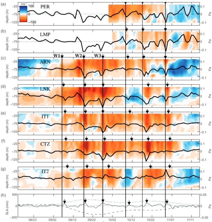
Coastally trapped waves were identified on the
TAVE shelf by Dubranna et al. (2011) in the current
observations associated to the intrusion of cold fronts with intense along-shore downcoast winds (Fig. 7). They identified two events in September and two in October. The phase speed of the coastal waves was
estimated at 2.9 ms–1, which was corroborated with
the increase of the sea level in Veracruz city in both episodes.
5.3 The West Florida Shelf
as the shelf narrows to join the northwest Florida Panhandle shelf inshore of DeSoto Canyon. The DeSoto Canyon is an area with a narrow steep shelf, potentially allowing more interaction of the inner
shelf with the deep gulf. The WFS has been largely studied by long-term mooring observations and mod-els (He and Weisberg, 2002, 2003; Weisberg and He,
2003; Liu and Weisberg, 2005; Weisberg et al., 2005;
(a)
(b)
(c)
(d)
(e)
(f)
(g)
(h)
0.1
–25 ms–1
–75
–125
–25
–75
–125
–25
–75
–125
–25
–75
–125
–25
–75
–125
–25
–75
–125
–25
–75
–125
0 500
–500
–0.1
Pa
depth (m)
depth (m)
depth (m)
depth (m)
depth (m)
depth (m)
depth (m)
SL
A
(mm)
0
0.1
–0.1
Pa
0
08/23 09/02 09/12 09/22 10/02
Date 10/12 10/22 11/01 11/11
0.1
–0.1
Pa
0
0.1
–0.1
Pa
0
0.1
–0.1
Pa
0
0.1
–0.1
Pa
0
0.1
–0.1
0.05
–0.05
Pa
Pa
0
0
Fig. 7. Alongshore current velocities (cm s–1) measured by the moorings: (a) PER, (b) LMP, (c) ARN, (d) LNK,
Maksimova and Clarke, 2013). On average, the WFS has southeastward (northwestward) circulation on the inner shelf and upwelling (downwelling) favorable conditions during autumn-winter (summer). The inner-shelf circulation is decoupled from the middle and outer shelf circulation since frequently they have different direction (Liu and Weisberg, 2005). The explanation for this difference is a return flow that develops because the Florida Keys are a barrier to the flow, thus when there is a southeastward flow in the inner shelf, it reaches the Keys and a return flow develops. Mixing and surface heat fluxes also affect the dynamics because the inner shelf increases (de-creases) its temperature faster than the intermediate shelf in the spring (autumn), developing cross-shelf pressure gradients that reinforce the circulation differences between the inner and intermediate shelf. The Loop Current interacts with the slope and develops pressure gradients that affect the shelf circulation.
5.4 The Campeche Bank
The Campeche Bank includes the broad shelf to the north and the narrower shelf to the northwest of the Yucatan Peninsula. There have been few observational studies on the hydrodynamics of the Campeche Bank, most of them based on hydro-graphic data (e.g. Cochrane, 1969; Merino, 1997). The winds over the Campeche Bank are upcoast, with an eastward component, throughout the year, and are more intense in April-June and weaker in
September-October (Enríquez et al., 2010). The
currents are mainly westward, fed by the Yucatan Current waters (for the Yucatan Current see for
example Ochoa et al., 2001; Sheinbaum et al.,
2002). Zavala-Hidalgo et al. (2003), based on a
numerical study, reports that on a monthly scale the transports north of the Yucatan state are upcoast year round in the inner and middle shelf. In the western Campeche Bank, transports on the inner shelf are upcoast and on the middle shelf the transports are also upcoast but they decrease during October.
Re-sults from Sanvicente-Añorve et al. (2014) suggest
that, over the outer shelf of the western Campeche Bank, the current is downcoast during September and October and the rest of the year has variable direction. The need for observational studies in the Campeche Bank region is quite evident from the literature review.
6. Cross-shelf transports
As mentioned above, cross-shelf transports are con-strained by the conservation of potential vorticity, such that the barotropic circulation is dominantly in the along-isobath direction. Therefore, cross-shelf transports imply that either there is strong barocli-nicity, or friction and other terms are important in the momentum balance equation, making these motions less frequent than along-shelf motions. On the other hand, cross-shelf motions are important because they may carry nutrient rich subsurface water onto the
shelf, andthe shelf may bring riverine low salinity
waters into the deep ocean. Also, cross-shelf trans-ports may carry contaminants coming from inland into the deep ocean, or from the deep ocean onto the shelf as happens when there are deep ocean oil-spills. Larvae are also transported from the shelf to the deep
ocean or vice versa (Sanvicente-Añorve et al., 2014).
In the GoM, eddy-pairs have been associated with cross-shelf transports (Biggs and Müller-Karger, 1994), but it has been demonstrated that there are regions with some seasonality in the cross-shelf trans-ports not always related to eddy-pairs. The following summarizes those results.
Spatial variability of wind-driven circulation on the shelves results in differences in along-shelf transport, which in turn lead to regions of conver-gence or diverconver-gence. As seen in previous sections, this may be caused by the corresponding conver-gence or diverconver-gence of the along-coast wind com-ponent, which can occur due to spatial variability of the wind field or changes in orientation of the shelf under a relatively homogeneous wind field. The low frequency along-coast wind component has a region of convergence in the southernmost part of the GoM, mainly from September to February although present throughout the year; in the south-ern Texas shelf there is convergence between April and August. These two regions were identified to have large seasonality in their associated values of chlorophyll-a concentration and low salinity waters
(Morey et al., 2003a, b, 2005; Zavala-Hidalgo et al.,
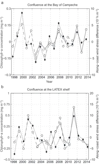
Zavala-Hidalgo (2009) showed that the interannual variability of the chlorophyll-a concentration off-shore of the southern Texas shelf and in the Bay of Campeche might be explained by the interannual variability of the along-coast wind stress compo-nent and the corresponding of the shelf currents. Here, we extend the period of their computations and found that high correlations remain, explaining a large fraction of the interannual variability of chlorophyll-a concentration by the convergence of mass induced by the along-coast currents in those regions (Fig. 9). The chlorophyll-a concentration values over the southern Bay of Campeche were averaged in a box located between 19.5º N and 20.5º N in latitude and 93º W and 92º W in longitude. For the southern Texas shelf, the box limits were 26.5º N to 27.5º N in latitude and 96.75º W to 96º W in longitude.
7. Upwelling
Coastal upwelling has strong seasonality in the GoM, but occurs at different periods over different shelves. The TAVE shelf, in the western GoM, has
upwelling conditions predominantly during summer,
as has been identified in satellite images (Walker et
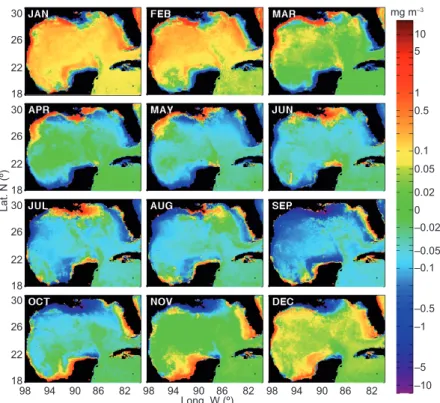
al., 2003; Walker, 2005; Zavala-Hidalgo et al., 2006)
(Fig. 10). The analysis in Mateos-Jasso et al. (2012),
based on long-term almost continuous measurements of temperature in the water column at the Sistema Arrecifal Veracruzano (SAV), offshore of Veracruz city, shows stratification between April and Sep-tember with low temperature near the bottom due to upwelling in the region. The upwelling is interrupted by the influence of tropical systems, like easterly waves and tropical storms, which change the Ekman transport from upwelling to downwelling conditions increasing temperature of the entire water column (Fig. 11). The signature of the upwelled water in the SST is relatively weak because the outcropping of the isotherms is not often observed in the satellite images. Upwelling and downwelling over the WFS occur in almost opposite seasons than in the TAVE shelf, with upwelling occurring in winter and downwelling in
summer (Weisberg et al., 2005). There are important
differences between the upwelling in the WFS and the TAVE shelves, since northerly winds in winter 30
10 5
1
0.1 0.05 0.02 0 –0.02
–0.05 –0.1
–0.5 –1
–5 –10 mg m–3
0.5 26
22
18 30
26
Lat. N (º
) 22 18 30
26
22
18 30
98 94 90 86 82 98 94 90 86 82 98 94 90 86 82
Long. W (º) 26
22
18
that induce upwelling (downwelling) in the WFS (TAVE) are more intense than the southeasterlies in summer that induce downwelling (upwelling) in the WFS (TAVE).
8. Discussion and final remarks
The surface momentum and heat fluxes are intense in the GoM and are important for its hydrodynamics. As a consequence of these fluxes the mixed layer depth changes seasonally, being deeper in winter and there is a contribution on the winter cooling due to the entrainment of subsurface low temperature
water that reaches the mixed layer. The entrainment also carries nutrients into the upper layer, increas-ing the chlorophyll-a concentration durincreas-ing winter months. Research on the importance of local forcing in the GoM has shown that shelves respond to wind stress and buoyancy fluxes due to surface heat fluxes and fresh water inputs. The response to the local forcing is more clear or, in some cases, limited to the inner shelf that develops along-shore currents as a consequence of the surface Ekman transport that induces cross-shelf pressure gradients and geo-strophic along-coast currents. The heat fluxes also can induce cross-shelf pressure gradients because temperature decreases (increases) faster in autumn (spring) in the shallower regions, as has been shown for the WFS. The wide shelves, as the LATEX, the WFS and the Campeche Bank, have a well defined inner shelf strongly influenced by the along-coast wind stress. The external shelf has the influence of the Loop Current and the Loop Current eddies through their interaction with the slope, but still there are many open questions on these processes. a
Confluence at the LATEX shelf b
Year
Chlorophyll−a concentration (mg
m
–3)
−0.3 −0.15 0 0.15 0.3
−10 − 5 0 5 10
Along−coast wind stress dif
ference (1
0
–3n
m
–2)A
long−coast wind stress dif
ference (1
0
–3n
m
–2) Confluence at the Bay of Campeche
Year
1998 2000 2002 2004 2006 2008 2010 2012 2014 1998 2000 2002 2004 2006 2008 2010 2012 2014
1998 2000 2002 2004 2006 2008 2010 2012 2014 1998 2000 2002 2004 2006 2008 2010 2012 2014
Chlorophyll−a concentration (mg
m
–3)
–10 −5 0 5 10 15 20
−0.5 −0.25 0 0.25 0.5 0.75 1
Fig. 9. Alongshelf wind convergence anomalies (gray-thick line) and chlorophyll-a concentration anomalies from both SeaWiFS data (dashed line) and MODIS data (solid line). Upper panel: October-November anomalies in the Bay of Campeche. Lower panel: April-June anomalies in the southern Texas shelf. Following computations from Martínez-López and Zavala-Hidalgo (2009).
30
JUL
29
28.5
28
27.5
27
26.5
26
25.5
25 ºC
Lat. N (º
)
25
20
95
Long. W (º) 90
In the Bay of Campeche and offshore of the southern LATEX shelf, seasonality has been identified in cross-shelf transports as a result of the influence of the along-shelf wind stress com-ponent. This behavior has also been observed by the seasonality of the chlorophyll-a concentration estimated from satellites in those regions and by the modeled offshore export of low salinity waters. Also, the seasonality of the chlorophyll-a concen-tration, offshore of the Mississippi river mouth, was reported and explained as a consequence of the seasonality of the wind stress direction, which favors a westward transport in the northern GoM during summer.
Acknowledgements
We thank Octavio Gómez-Ramos for his help with the computer systems. To Ángel Ruiz Angulo and an anon-ymous reviewer for their valuable suggestions that improved the manuscript. This work was supported by grants PAPIIT IN116111, PAPIIT RR116111, and CONACyT 133299. Steven L. Morey was supported by a grant from the BP/Gulf of Mexico Research Initiative to the Deep-C Consortium and by a NASA grant as part of the Ocean Vector Winds Science Team.
References
Adem J., E. E. Villanueva-Urrutia and V. M. Mendoza, 1993. A new method for estimating the seasonal cycle Fig. 11. Annual time series of temperature at the surface and bottom (30 m) in the northern Veracruz Coral Reef System for the years 2007-2012. SSTs from the AVHRR (blue); bottom temperature from an ADCP recorded every 30 min (green), and temperature measured by a moored thermistor at 27 m (purple). Black line represents the 24-h running mean (following Mateos-Jasso et al., 2012).
18 20 22 24 26 28 30
ºC
ºC
ºC
ºC
ºC
ºC
2007
18 20 22 24 26 28
30 2008
18 20 22 24 26 28
30 2009
18 20 22 24 26 28
30 2010
18 20 22 24 26 28
30 2011
18 20 22 24 26 28
30 2012
of the heat balance, with application to the Gulf of Mexico. Geofis. Int. 32, 21-34.
Biggs D. C. and F. E. Müller-Karger, 1994. Ship and sat-ellite observations of chlorophyll stocks in interacting cyclone-anticyclone eddy pairs in the western Gulf of Mexico. J. Geophys. Res.99, 7371-7384.
Boicourt W. C., W. J. Wiseman Jr., Valle-A. Levinson and L. P. Atkinson, 1998. Continental shelf of the south-eastern United States and the Gulf of Mexico: In the shadow of the western boundary current. In: The sea, vol. 11 (A. R. Robinson and K. H. Brink, Eds.). John Wiley, Hoboken, N. J., pp. 135-182.
Burphee W. R., 1974. Characteristics of north african easterly waves during the summers of 1968 and 1969.
J. Atmos. Sci.31, 1556-1570.
Capurro L. R. A. and J. L. Reid (Eds.), 1972. Contributions on the physical oceanography of the Gulf of Mexico, vol. II. Gulf Publishing, Houston, Texas, 288 pp. Cho K., R. O. Reid and W. D. Nowlin Jr., 1998. Objectively
mapped stream function fields on the Texas-Louisiana shelf based on 32 months of moored current meter data.
J. Geophys. Res.103, 10377-10390.
Cochrane J. D., 1969. Water and circulation on Campeche Bank in May. Papers in Dedication to Professor Mich-itaka Uda. Special Bulletin of the Japanese Society of Fisheries Oceanography, 123-129.
Cochrane J. D. and F. J. Kelly, 1986. Low-frequency cir-culation on the Texas- Louisiana continental shelf. J. Geophys. Res.91, 10645-10659.
Diedhiou A., S. Janicot, A. Viltard, P. de Felice and H. Laurent, 1999. Easterly wave regimes and associated convection over West Africa and tropical Atlantic: Re-sults from the NCEP/NCAR and ECMWF reanalyses.
Clim. Dynam. 15, 795-822
DiMego G. J., L. F. Nosart and G. W. Endersen, 1976. An examination of the frequency and mean condi-tions surrounding frontal incursions into the Gulf of Mexico and Caribbean Sea. Mon. Weather Rev.104, 709-718.
Dubranna J., P. Pérez-Brunius, M. López and J. Candela, 2011. Circulation over the continental shelf of the western and southwestern Gulf of Mexico. J. Geo-phys. Res.116, doi:10.1029/2011JC007007.
Enríquez C., I. J. Marinño-Tapia and J. A. Herrera-Siveira, 2010. Dispersion in the Yucatan coastal zone: Implica-tions for red tide events. Cont. Shelf Res.30, 127-137. Etter P. C., 1983. Heat and fresh water budgets in the Gulf
of Mexico. J. Phys. Oceanogr.3, 2058-2069.
Etter P. C., P. J. Lamb and D. H. Portis, 1987. Heat and
fresh water budgets in the Caribbean Sea with revised estimates for the Central American Seas. J. Phys. Oceanogr.7, 232-1248.
Galtsoff P. S., 1954. Gulf of Mexico: Its origin, waters, and marine life. In: Fishery Bulletin, vol. 89. U.S. Fish and Wildlife Service.
Gutiérrez de Velasco G. and C. Winant, 1996. Seasonal patterns of wind stress and wind stress curl over the Gulf of Mexico. J. Geophys. Res.101, 18127-18140. Hastenrath S. L., 1968. Estimates of latent and sensible
heat flux for the Caribbean and the Gulf of Mexico.
Limnol. Oceanogr.3, 322-331.
Hastenrath S. L. and P. Lamb, 1968. Heat budget atlas of the tropical Atlantic and eastern Pacific Oceans. University of Wisconsin Press, Madison, 90 pp. He R. and R. H. Weisberg, 2002. West Florida shelf
cir-culation and temperature budget for the 1999 spring transition. Cont. Shelf Res. 22, 719-748.
He R. and R. H. Weisberg, 2003. A loop current intrusion case study on the West Florida Shelf. J. Phys. Ocean-ogr. 33, 465-477.
Kraus E. B. and J. S. Turner, 1967. A one-dimensional model of the seasonal thermocline. II. The general theory and its consequences. Tellus19, 98-106. Liu Y. and R. H. Weisberg, 2005. Momentum balance
diagnoses for the West Florida Shelf. Cont. Shelf Res.
25, 2054-2074.
Liu Y., A. MacFadyen, Z.-G. Ji and R. H. Weisberg (Eds.), 2011. Monitoring and modeling the deepwater hori-zon oil spill: A record-breaking enterprise. American Geophysical Union, Washington, DC, doi: 10.1029/ GM195, 271 pp. (Geoph. Monog. Series, 195). López-Méndez J. V., 2009. Análisis del evento
meteo-rológico relacionado con la inundación de Tabasco del 2007. M.Sc. Thesis,Posgrado en Ciencias de la Tierra, Universidad Nacional Autónoma de México, 117 pp.
Maksimova E. V. and A. J. Clarke, 2013. Multiyear sub-inertial and seasonal Eulerian current observations near the Florida Big Bend Coast. J. Phys. Oceanogr.
43,1691-1709.
Martínez-López B. and J. Zavala-Hidalgo, 2009. Seasonal and interannual variability of cross-shelf transports of chlorophyll in the Gulf of Mexico. J. Marine Syst.
77, 1-20.
Mendoza M., E. E. Villanueva and J. Adem, 2005. On the annual cycle of the sea surface temperature and the mixed layer depth in the Gulf of México. Atmósfera
18, 127-148.
Merino M., 1997. Upwelling on the Yucatan shelf: Hydro-graphic evidence. J. Mar. Syst. 13, 101-121.
Morey S. L., P. J. Martin, J. J. O’Brien, A. A. Wallcraft and J. Zavala-Hidalgo, 2003a. Export pathways for river discharged fresh water in the northern Gulf of Mexico.
J. Geophys. Res.108, doi:10.1029/2002JC001674. Morey S. L., W. Schroeder, J. J. O’Brien and J.
Zava-la-Hidalgo, 2003b.The annual riverine influence in the eastern Gulf of Mexico. Geophys. Res. Lett.30, 1867, doi:10.1029/2003GL017348.
Morey S. L., J. Zavala-Hidalgo and J. J. O’Brien, 2005. The seasonal variability of continental shelf circulation in the northern and western Gulf of Mexico from a high-resolution numerical model. In: Circulation in the Gulf of Mexico, observations and models (W. Sturges, Ed.). American Geophysical Union, Washington, DC, doi: 10.1029/161GM01, pp. 203-218 (Geoph. Monog. Series, 161).
Nowlin W. D., Jr. and C. A. Parker, 1974. Effects of a cold-air outbreak on shelf waters of the Gulf of Mexico.
J. Phys. Oceanogr.4, 467-486 .
Nowlin W. D., Jr., A. E. Jochens, R. O. Reid and S. F. Di-Marco, 1998a. Texas-Louisiana shelf circulation and transport processes study:Synthesis report. Volume I: Technical report. OCS Study MMS98-0035. U.S. Department of the Interior, Minerals Management Service, Gulf of Mexico OCS Region, New Orleans, Louisiana, 502 pp.
Nowlin W. D. Jr., A. E. Jochens, R. O. Reid and S. F. DiMarco, 1998b. Texas-Louisiana shelf circulation and transport processes study: Synthesis report. Vol-ume II: Appendices. OCS Study MMS-98-0036. U.S. Department of the Interior, Minerals Management Service, Gulf of Mexico OCS Region, New Orleans, Louisiana, 288 pp.
Nowlin W. D. Jr., A. E. Jochens, S. F. DiMarco, R. O. Reid and M. K. Howard, 2005. Low-frequency cir-culation over the Texas-Louisiana continental shelf. In: Circulation in the Gulf of Mexico, observations and models (W. Sturges, Ed.). American Geophysical Union, Washington, DC, doi: 10.1029/161GM01, pp. 219-240 (Geoph. Monog. Series, 161).
Ochoa J., J. Sheinbaum, A. Badan, J. Candela and D. Wilson, 2001. Geostrophy via 343 potential vorticity inversion in the Yucatan Channel. J. Mar. Res. 59, 725-747.
Oey L.-Y, 1995. Eddy and wind-forced shelf circulation.
J. Geophys. Res.100, 8621-8637.
Pérez-Brunius P., P. García-Carrillo, J. Dubranna, J. Sheinbaum and J. Candela, 2012. Direct observations of the upper layer circulation in the southern Gulf of Mexico. Deep-Sea Res.85, 82-94, doi.org/10.1016/j. dsr2.2012.07.020.
Romero-Centeno R., J. Zavala-Hidalgo, A. Gallegos and J. J. O’Brien, 2003. Isthmus of Tehuantepec wind cli-matology and ENSO signal. J. Climate16, 2628-2639. Rudzin J. E., S. L. Morey, M. A. Bourassa and S. R. Smith, 2013. The influence of Loop Current position on winter sea surface temperatures in the Florida Straits. Earth Interact.17, doi: 10.1175/2013EI000521.1.
Sanvicente-Añorve L., J. Zavala-Hidalgo, M. E. Allen-de-Arandía and M. Hermoso-Salazar, 2014. Connec-tivity patterns among coral reef systems in the southern Gulf of Mexico. Mar. Ecol. Prog. Ser.498, 27-41. Sheinbaum J., J. Candela, A. Badan and J. Ochoa, 2002.
Flow structure and transport in the Yucatan Channel.
Geophys. Res. Lett.29, doi:10.1029/2001GL013990. Sturges W., A. Lugo-Fernández (Eds.), 2005. Circulation
in the Gulf of Mexico: Observations and models. American Geophysical Union, Washington, DC, doi: 10.1029/161GM01, 347 pp. (Geoph. Monog. Series, 161).
Vázquez de la Cerda A. M, R. O. Reid, S. F. DiMarco and A. E. Jochens, 2005. Bay of Campeche cir-culation: An update. In: Circulation in the Gulf of Mexico, observations and models (W. Sturges, Ed.). American Geophysical Union, Washington, DC, doi: 10.1029/161GM01, pp. 279-293 (Geoph. Monog. Series, 161).
Villanueva E. E., V. M. Mendoza and J. Adem, 2010. Sea surface temperature and mixed layer depth changes due to cold-air outbreak in the Gulf of Mexico. Atmósfera
23, 325-346.
Walker N., S. Myint, A. Babin and A. Haag, 2003. Ad-vances in satellite radiometry for the surveillance of surface temperatures, ocean eddies and upwelling processes in the Gulf of Mexico using GOES-8 mea-surements during summer. Geophys. Res. Lett. 30, doi:10.1029/2003GL017555.
Walker N. D, 2005. Seasonal changes in temperatures, shelf and slope circulation and coastal upwelling in the northwestern Gulf of Mexico, and coastal upwelling in the northwestern Gulf of Mexico. In:
American Geophysical Union, Washington, DC, doi:10.1029/161GM16 (Geoph. Monog. Series, 161).
Wang W., W. D. Nowlin Jr. and R. O. Reid, 1998. Analyzed surface meteorological fields over the northwestern Gulf of Mexico for 1992-94: mean, seasonal, and monthly patterns. Mon. Weather Rev.
126, 2864-2883.
Weisberg R. H. and R. He, 2003. Local and deep ocean forcing contributions to anomalous water properties on the West Florida Shelf. J. Geophys. Res. 108, doi:10.1029/2002JC001407.
Weisberg R. H., R. He, Y. Liu and J. I. Virmani, 2005. West Florida shelf circulation on synoptic, seasonal, and interannual time scales. Geog. Monog. Series 161, 325-347.
Zavala-Hidalgo J., A. Parés-Sierra and J. Ochoa, 2002. Seasonal variability of the temperature and heat fluxes in the Gulf of Mexico. Atmósfera15, 81-104.
Zavala-Hidalgo J., S. L. Morey and J. J. O’Brien, 2003. Seasonal circulation on the western shelf of the Gulf of Mexico using a high-resolution numerical model.
J. Geophys. Res.108, doi:10.1029/2003JC001879. Zavala-Hidalgo J., B. Martínez, A. Gallegos, S. L.
Morey and J. J. O’Brien, 2006. Seasonal upwelling on the western and southern shelves of the Gulf of Mexico. Ocean Dynam. 56, doi:10.1007/s10236-006-0072-3.