Atmospheric Pollution
Lecture 11 Sahraei Physics Department Razi university http://www.razi.ac.ir/sahraei 12 The equator receives more direct radiation from the Sun. A ray of light from the Sun hits the ground at an angle near the poles so it’s spread out more. More radiation at the equator means the ground (or ocean) is warmer, so it warms up the air, which rises.
3
GLOBAL CIRCULATION OF THE ATMOSPHERE
Simplified one-cell global air circulation patterns
The first model will be founded on the following simplifying assumptions:
The Earth is not rotating in space.
The Earth's surface is composed of similar materials.
The global reception of solar insolation and loss of longwave radiation cause a temperature gradient of hotter air at the equator and colder air at the poles.
L L L
H
4 Air pollution is affected by winds, winds are affected by large-scale pressure systems, and large-scale pressure systems are affected by the global circulation of the atmosphere.
GLOBAL CIRCULATION OF THE ATMOSPHERE
Figure shows features of the global circulation, including the major circulation cells, the belts of low and high pressure, and the predominant wind directions.
P o lar cell F errel cell Had ley cell H Eq u ato rial lo w - 0 oN (Do ld ru ms), ITCZ S u b tro p ical h ig h - 3 0 oN
(Ho rse latitu d es)
S u b p o lar lo w - 6 0 oN
P o lar h ig h - 9 0 oN
P o lar h ig h - 9 0 oS S u b tro p ical h ig h - 3 0 oS
S u b p o lar lo w 6 0 oS
No rth east trad e win d s S o u th westerlies
S o u th east trad e win d s
No rth westerlies P o lar easterlies P o lar easterlies H H H L L L L P o lar cell F errel cell Had ley cell H H L L West East
5
Winds have a west-east (zonal), south-north (meridianal), and vertical component.
The three circulation cells in each hemisphere shown in Fig. Represent the meridianal and vertical components of the Earth’s winds, averaged zonally (over all longitudes) and over a long time period.
6
The cells are symmetric about the equator and extend up to the tropopause, which is near 18 km altitude over the equator and near 8 km altitude over the poles.
P o lar cell F errel cell Had ley cell H Eq u ato rial lo w - 0 oN (Do ld ru ms), ITCZ S u b tro p ical h ig h - 3 0 oN
(Ho rse latitu d es)
S u b p o lar lo w - 6 0 oN
P o lar h ig h - 9 0 oN
P o lar h ig h - 9 0 oS S u b tro p ical h ig h - 3 0 oS
S u b p o lar lo w 6 0 oS
No rth east trad e win d s S o u th westerlies
S o u th east trad e win d s No rth westerlies P o lar easterlies P o lar easterlies H H H L L L L P o lar cell F errel cell Had ley cell H H H L L L West East
7
Two cells, called Hadley cells, extend from 0 to 30N and S latitude, respectively.
the middle cell in the three-cell model is named the Ferrel cell.
Ferrel cells extend from 30 to 60 in the Northern and Southern Hemispheres. Two Polar cells extend from 60 to 90N and S latitude, respectively. P o lar cell F errel cell Had ley cell H Eq u ato rial lo w - 0 oN (Do ld ru ms), ITCZ S u b tro p ical h ig h - 3 0 oN
(Ho rse latitu d es)
S u b p o lar lo w - 6 0 oN
P o lar h ig h - 9 0 oN
P o lar h ig h - 9 0 oS S u b tro p ical h ig h - 3 0 oS
S u b p o lar lo w 6 0 oS
No rth east trad e win d s S o u th westerlies
S o u th east trad e win d s No rth westerlies P o lar easterlies P o lar easterlies H H H L L L L P o lar cell F errel cell Had ley cell H H H L L L West East
9 Global upper ocean circulations and subtropical gyres; red marks the warm ocean currents and blue marks the cool ocean currents.
10
The circulation cells of the global atmospheric circulation system migrate north and south with the seasons.
11 Equatorial Low-Pressure Belt
Subtropical High-Pressure Belts
The Trade Winds
As air converges at the subtropical fronts at 30N and S, much of it descends. Air is drawn in horizontally aloft to replace the
descending air.
At the surface at 30N and S, descending air diverges both equatorward and poleward.
Winds Aloft in the Hadley Cells
As air diverges toward the north in the elevated part of the Northern Hemisphere Hadley cell, the ACoF deflects much of it to the right (to the east), giving rise to westerly winds aloft (winds are generally named after the direction that they originate
12 SEMIPERMANENT PRESSURE SYSTEMS
THERMAL PRESSURE SYSTEMS
EFFECTS OF LARGE-SCALE PRESSURE SYSTEMS ON AIR POLLUTION
List the semi permanent high and low pressure systems that affect the weather patterns over the Northern Hemisphere.
Bermuda high → located over the mid Atlantic ocean
Pacific high → located off the western U.S. coastline
Icelandic low → located over southern Greenland and Iceland
13
Bermuda high
strongest in the summer and shifts west towards the United States
14
Pacific high
Pacific high strongest in the summer and shifts north
Icelandic low much stronger in the winter and shifts to the west, some years it will be located over eastern Canada
15
Aleutian Island
much stronger in the winter and shifts south to the Gulf of Alaska
16 Four weak shallow thermal pressure systems form over the Northern Hemisphere that are not considered semi permanent features. What are their names, and when and where do they form?
Canadian thermal high → forms in the winter over west-central Canada (Responsible for our cold winter days in North Dakota)
Siberian thermal high → forms in the winter over eastern Russia, can become rather strong (Responsible for the dry Monsoon Season from December - February in India/SW Asia)
Southwestern US thermal low → forms in the summer over the desert southwest region of the United States (Responsible for the weak Monsoon Season in July - August)
Iran thermal low → forms in the summer over the Iranian plateau
(Responsible for the wet Monsoon Season from June - September in India/SW Asia)
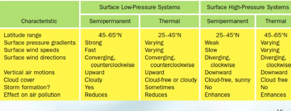
EFFECTS OF LARGE-SCALE PRESSURE SYSTEMS ON AIR POLLUTION
Semipermanent and thermal pressure systems affect air pollution.
Table compares characteristics of such pressure systems, including their effects on pollution.