Valero Medina, J.A. and Lizarazo Salcedo, I.A. and Elsner, Paul (2014)
Topological challenges in multispectral image segmentation. Tecnura 18 ,
pp. 136-149. ISSN 0123-921X.
Downloaded from:
Usage Guidelines:
Please refer to usage guidelines at or alternatively
DOI: http://doi.org/10.14483/udistrital.jour.tecnura.2014.DSE1.a12
R
eflexión* Systems Engineer, master in Teleinformatics, PhD student in engineering. Associate Professor of the Universidad Distrital Francisco José de Caldas. Bogotá, Colombia. Contact: [email protected]
** Civil Engineer, PhD in Geography. Titular Professor of the Universidad Distrital Francisco José de Caldas. Bogotá, Colombia. Contact: [email protected]
*** Physical Geographer. PhD in Geography. Lecturer in Geographical Information Science and Physical Geography, University of London. London, United Kingdom. Contact: [email protected]
Topological challenges in multispectral image segmentation
Retos topol
ó
gicos en la segmentación de imágenes multiespectrales
José Antonio Valero Medina*, Iván Alberto Lizarazo Salcedo**, Paul Elsner***
Fecha de recepción: June 10th, 2014 Fecha de aceptación: November 4th, 2014
Citation / Para citar este artículo: Rodríguez, A. A., Perdomo Orjuela, L. E., Santamaría Piedrahíta, F., & Gómez Vargas, C. A. (2014). Transient surges analysis in low voltage networks. Revista Tecnura, 18 (Edi-ción especial doctorado), 136–149. doi: 10.14483/udistrital.jour.tecnura.2014.DSE1.a12
ABSTRACT
Land cover classification from remote sensing mul-tispectral images has been traditionally conducted by using mainly spectral information associated with discrete spatial units (i.e. pixels). Geometric and to-pological characteristics of the spatial context close to every pixel have been either not fully treated or completely ignored. This article provides a review of the strategies used by a number of researchers in or-der to include spatial and topological properties in image segmentation. It is shown how most of resear-chers have proposed to perform -previous to classifi-cation- a grouping or segmentation of nearby pixels by modeling neighborhood relationships as 4-con-nected, 8-connected and (a, b) – connected graphs. In this object-oriented approach, however, topolo-gical concepts such as neighborhood, contiguity, connectivity and boundary suffer from ambiguity since image elements (pixels) are two-dimensional entities composing a spatially uniform grid cell (i.e. there are not uni-dimensional nor zero-dimensional elements to build boundaries). In order to solve such
topological paradoxes, a number of approaches are proposed. This review discusses how the alternati-ve of digital images representation based on Carte-sian complexes suggested by Kovalevsky (2008) for image segmentation in computer vision, does not present topological flaws that are typical for conven-tional solutions based on grid cells. However, such approaches have not yet been applied to multispec-tral image segmentation in remote sensing. This re-view concludes suggesting the need to research on the potential of using Cartesian complexes for mul-tispectral image segmentation.
Keywords: multispectral images, segmentation, to-pologic space.
RESUMEN
INTRODUCTION
Land cover classification from remote sensing im-ages has been traditionally conducted by using mainly spectral information associated with dis-crete spatial units (i.e. pixels). However, there have been a number of attempts to include both geo-metric and topological characteristics of the pixel neighborhood in the image analysis process (de Jong & Van der Meer, 2004). In the last decade, a number of concepts, methods and techniques for object-oriented image analysis (OBIA) have been developed and evaluated (Blaschke, 2010). The OBIA analysis process starts by grouping spectrally similar and spatially close pixels into segments. A meaningful segmentation is essential for the sub-sequent analysis stages (Lizarazo & Elsner, 2009).
Most of the multispectral image segmenta-tion algorithms assume images are a continuous space similar to the real world they depict. How-ever, the digital representation that is finally avail-able in any computer is performed by sampling the space and discretizing reality. In addition, multi
and hyper-spectral digital images are composed of square picture elements with similar size, which is clearly inaccurate (Cracknell, 1998). This inaccur-acy is present in representations of images such as 4-connected, 8-connected and -connected graphs (Rosenfeld, 1970; Kong & Rosenfeld, 1991).
Digital image processing based on represen-tations of space that do not meet the topological axiomatic postulates causes finally geometric al-gorithms to be affected by paradoxes that lead to ambiguous or erroneous decisions. While it can be accepted that a raster image matches human perception to some degree, the truth is that sev-eral important concepts for image analysis, such as the connectivity of regions, their boundaries, and the adjacency between them, are ambiguously represented. This lack of topological awareness of grid-based image representation is clearly an im-portant limitation for image analysis in computer environments (Kovalevsky, 1989). The alternative approach of digital images representation is based on complex Cartesian, suggested by Kovalev-sky (2008). This concept does not present topo-logical paradoxes that are typical of conventional
de una manera incompleta. En este artículo se reali-za una revisión de las estrategias que han sido em-pleadas por diversos investigadores con el propósito de incluir características topológicas y espaciales en segmentación de imágenes. La revisión muestra cómo la mayoría de ellos se han enfocado en rea-lizar, antes de la clasificación, un agrupamiento o segmentación de los píxeles cercanos modelando las relaciones de vecindario como grafos 4-conectados, 8-conectados y (a,b)-conectados. Sin embargo, en este enfoque orientado a objetos, conceptos topo-lógicos como vecindario, contigüidad, conectividad y límite sufren de ambigüedad ya que los elementos de la imagen (píxeles) son entidades bidimensiona-les que componen una retícula espacialmente uni-forme. Existen algunas propuestas alternativas que
buscan resolver dichas paradojas topológicas. En este artículo se analiza cómo la representación al-ternativa de imágenes digitales con base en comple-jos cartesianos sugerida por Kovalevsky (2008), para la segmentación de imágenes de visión de compu-tador, no presenta las paradojas topológicas de las soluciones convencionales basadas en retículas. Sin embargo, dicha propuesta no se ha explorado en los procesos de segmentación y clasificación de imágenes de sensores multiespectrales. Esta revi-sión concluye sugiriendo la necesidad de investigar el potencial de los complejos cartesianos en la seg-mentación de imágenes multiespectrales.
solutions based on grid cells. Kovalevsky (2006) suggested such an alternative image representa-tion using axiomatic locally finite spaces (ALFS) based on Cartesian complexes, a type of abstract cell complexes (ACC) (Listing, 1862). It has been stated that this alternative space does not arise topological paradoxes commonly found in con-ventional solutions (Pavlidis, 1977; Kovalevsky, 1984). Furthermore, it has been suggested that this alternative spaces could be a strong foundation for image segmentation in computer vision (Kovalev-sky, 2006). However, to the best knowledge of the author, the usage of such ALFS spaces has not been yet explored for segmentation and classification of remotely sensed multispectral images.
On the other hand, it is well known that al-gorithms based on geometric characteristics have high complexity since the number of pos-sible situations to be considered increases signifi-cantly as it increases objects’ dimension under evaluation (Worboys & Duckham, 2004). Addi-tionally, another problem that arises during the im-plementation phase of geometric algorithms is the impossibility of having an accurate arithmetic in terms of real numbers (de Berg, Cheong, Kreveld, & Overmars, 2008). A number of authors have at-tempted to reduce this algorithmic complexity of geometric spaces by selecting a subset of geomet-rical characteristics and transforming them into combinatorial structures using oriented matroids (Whitney, 1935; Oxley, 2003; Richter-Gebert & Ziegler, 2004). Examples for complex applications that have benefitted from such approaches are counter clockwise (CC) systems (Knuth, 1992), tri-angulation of point sets (Pfeifle & Rambau, 2002; de Loera, Rambau, & Santos, 2010), and terrain visibility analysis (Saeedi, 2012). While algorith-mic complexity is part of the research reported here, it will not be further discussed due to lengths limitations.
This article begins introducing digital image segmentation basic principles. Next, it shows sev-eral attempts for involving geometric and topologic features in image segmentation. Then, it describes
how Kovalevsky`s (2008) proposal unambiguously includes topologic feature through the definition of digital topological spaces. Finally, conclusions are presented.
DIGITAL IMAGES SEGMENTATION
Traditional image segmentation is the process of subdividing an image into smaller regions based on some notion of homogeneity or cohesiveness among groups of pixels (Grady, 2012). Regions are determined by two dual kind of methods (Brun, Mokhtari, & Domenger, 2003): (i) the edge-de-tection methods, and (ii) the region based seg-mentation methods. The former determine edges between regions and then close them in order to define a partition. The latter group pixels according to a homogeneity criterion aiming to obtain a par-tition of the image into homogeneous regions. The segmentation on an image X (the space domain) subdivides it, based on a function (the feature do-main) defined on X, using a logical predicate P on subsets S of X (Equation (1) (Horowits & Pavlidis, 1976).
(1)
where e is a prescribed error tolerance. It should be noted that in general, for multispectral images, the space domain and the feature domain
; so , and . A segmentation of X is a partition of X into subsets Sj ,i = 1, ... , m for some such that: (i) , (ii) , (iii) , and (iv), and Sjare ad-jacent in X. The conditions (i) and (ii) ensures that the image is partitioned into a set of regions. The condition (iii) ensures that each region is homo-geneous according to the homogeneity criterion
as merging or bottom-up, divides the image into a large number of small regions, which are then merged to form larger regions. The other one, also referred to as splitting or top-down, successively divides the image into smaller and smaller regions until certain criteria are satisfied.
The information provided by a partition may be mainly geometric or topological. The geometrical information relate to each region considered sep-arately from the partition. The set of pixels com-posing one region, the region including one pixel or the boundary of a given region, may be clas-sified as geometrical information. The topological information describe the relationships between re-gions. The set of regions adjacent to a given region or the set of regions included in one region belong to the topological information field (Brun, Mokh-tari, & Domenger, 2003).
Image segmentation can be seen as a labeling problem (Ishikawa, 2012), taking from the image only the neighborhood topologic relationships and putting them on an undirected region adjacency graph (RAG) (Brice & Fennema, 1970; Cheevasu-vut, Maitre & Vidal-Madjar, 1986; Guigues, Ie Men & Cocquerez, 2001) along with a set of labels. The problem is then to find the best labeling according to the criteria in the problem’s requirements. An energy is a translation of the criteria into a function that evaluates how good the given labeling is. A smaller energy for a labeling means a better corres-ponding solution to the problem. Thus, the prob-lem becomes an energy minimization one that can be solved using general algorithms. As minimiza-tion of such energies, in general, is known to be NP-hard, graph cuts methods utilizing the s-t min-cut algorithms known in operations research are used.
For segmentation quality assessment, it is com-mon to use similarity metrics between a reference segmentation and the segmentation obtained, see, for example, Neubert, Herold, Meinel, & Blaschke (2008) (Lizarazo, 2014).
PREVIOUS WORK ON TOPOLOGY
PRESERVING SEGMENTATION
Kovalevsky (1989) showed how abstract cell complexes allow for implementing topological relations needed to unambiguously perform seg-mentation of digital images in computer vision by developing some algorithms (Kovalevsky, 2001), (Kovalevsky, 2005). However, the authors are not aware of recent studies that rigorously evaluate the appropriateness of Kovalevsky’s approach.
Felzenszwalb & Huttenlocher (2004) addressed the image segmentation problem by defining a predicate for measuring the evidence for a bound-ary between two regions using a graph-based rep-resentation of the image (Urquhart, 1982), (Zahn, 1971) and developing a greedy algorithm. An im-portant characteristic of the method is its ability to preserve detail in low-variability image regions while ignoring detail in high-variability regions. The evidence for a boundary between two regions is measured by comparing intensity differences across the boundary, and intensity differences be-tween neighboring pixels within each region.
likelihood methods. Furthermore, they claimed to achieve full correction of the salt-and-pepper ef-fect present in the latter classification technique.
Kong, Xu, & Wu (2006) extracted land use in-formation from a high spatial resolution image by using a multi-scale image segmentation approach. Urban land use was divided into different levels forming a hierarchical network structure, in which objects on the upper level are composed of objects in the lower level. Classification of image objects was performed based on attributes of color, shape, hierarchy and correlation characteristics between neighboring objects. Results showed that by in-cluding a variety of spectral and spatial features, it was possible to differentiate urban land use cat-egories that cannot be separated through conven-tional per-pixel classification methods based on spectral data only.
Letscher & Fritts (2007) introduced a hybrid split-merge method for image segmentation based on computational geometry and topology by using persistent homology. The algorithm uses edge-directed topology to split the image into three types of regions based on Delaunay triangulations of points in the edge map. One type of region cor-responds to objects of interests, and the remaining two types correspond to smaller regions that can be attached either to the first ones or form new objects themselves. Preliminary results showed a high quality image segmentation.
Johansen, Coops, Gergel, & Stange (2007) as-sessed the capacity of high spatial resolution sat-ellite images to discriminate structural stages of vegetation in forest ecosystems. Based on semi-variogram (Tso & Mather, 2009) experiments, they established that the most appropriate windows sizes for textural analysis were 3 x 3 and 11 x 11 pixels. They subsequently applied an object-oriented spec-tral and textural classification algorithm to produce a map of structural vegetation classes. The joint use of spectral and texture features improved thematic accuracy between 2% and 19% compared to the accuracy based only on spectral features.
Li & Sun (2010) proposed an “active image” segmentation method that distorts the image in or-der to match the so-called “initial” outlines and be able to segment multiple objects simultaneously. The deformation field was modeled using B-Spline free-form deformations. By penalizing the bending energy, they claimed to preserve both shape and local topology of objects of interest. Preliminary results, obtained using both synthetic and real im-ages, showed that the proposed method allowed coping with low-contrast and occlusion issues that cannot be overcome using simple criteria for im-age segmentation.
Arbeláez P., Maire, Fowlkes, & Malik (2011) presented a unified approach to contour detection and image segmentation. To produce high-quality image segmentations, the contour detector is linked with a generic grouping algorithm consisting of two steps. In the first one, a new image transformation called the Oriented Watershed Transform (OWT) is introduced for building a hierarchical segment-ation by exploiting the informsegment-ation in the con-tour signal (Arbeláez P., Maire, Fowlkes, & Malik, 2009). In the second one, using an agglomerative clustering procedure, an initial graph is built where the nodes are the initial regions. The links are the initial arcs separating adjacent regions, and the weights are a measure of dissimilarity between re-gions. The algorithm proceeds by sorting the links by similarity and iteratively merging the most simi-lar regions. The process produces a tree of regions where leaves are the initial regions, the root is the entire image, and the inclusion relation orders the regions in a multiscale fashion.
conventional (and inaccurate) 4-connected and 8-connected neighborhood relationships.
Arbeláez P., Maire, Fowlkes, & Malik (2009) pro-posed a bottom-up strategy improving the agglom-eration using more information besides boundary mean. Using supervised machine learning tech-niques they predicted whether two super pixels should be merged or not. In case of obtaining fea-tures combination lacking training data, addition-al training examples are generated by applying an active learning paradigm at every agglomeration hierarchy level. In active learning, the algorithm determines what example it wants to learn from at each iteration, based on the previous training data. The learning process is checked for accuracy using a coarse-scale ground truth image. They re-port the usage of a region adjacency graph (RAG), but do not provide a special topological represen-tation for it.
To summarize: It is apparent that, unlike the Kovalevsky’s approach, no other proposed method reports the usage of a space representation meet-ing the axiomatic postulates for topological spaces. Other approaches assume the correctness of either the underlying image representation using the conventional grid cell model or the graph-based image representation using 4- and 8-connected connectivity.
AXIOMATIC LOCALLY FINITE SPACES
(ALFS)
The classical conception of space applied in geo-graphic information systems (GIS) and multispec-tral imaging analysis is based on several concepts, including continuity. Continuity refers to the fact that a region can be always subdivided into smaller sub-regions (Stell & Webster, 2007). This concept is also known as dense sets (Worboys & Duckham, 2004). However, the digital representation is per-formed through space sampling that discretizes rea-lity. As it is impossible to find a bijective function (Cantor, 1883), traditional models of digital repre-sentation of geographical phenomena (Schneider,
1977) suffer from imprecision and inaccuracy and do not include, in the particular case of the digital images, a measure of topology. These imprecisions and inaccuracies are particularly significant when geographical relationships are modeled based on concepts such as neighborhood, contiguity, con-nectivity and boundary. If the digital representation of those relationships is not expressed properly, GIS technology may not be able to give appropria-te responses to several typical problems for remoappropria-te sensing image analysis such as segmentation and classification.
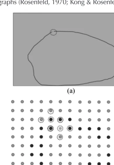
[image:7.654.342.537.355.637.2]Multi and hyper spectral digital images are com-posed of square picture elements with similar size, which is clearly inaccurate (Cantor, 1883). This in-accuracy is present in representations of images such as 4-connected, 8-connected and -connected graphs (Rosenfeld, 1970; Kong & Rosenfeld, 1991).
Figure 1. (a) Connection in a continuous space is established by removing a single element from the boundary between two sets; (b) there is a topological paradox to establish boundaries using 4-connected criteria in a conventional digital space
Figure 1(a) illustrates that in a continuous space, withdrawing a point from the boundary between the interior and exterior sets, previously discon-nected by a Jordan curve, these become connect-ed. Figure 1(b) shows how, in a discrete space, removing the element encircled in red from the boundary (blue points) does not connect the cor-responding interior and exterior sets based on the 4-connected criterion, which is illustrated using two neighborhoods (the central element of each one is depicted as a point encircled in red). Actual-ly, it is not possible either to establish unambigu-ously such a connectivity using the 8-connected criterion. In this case, for the example shown, the two sets remain always connected even without removing the element under consideration from the boundary.
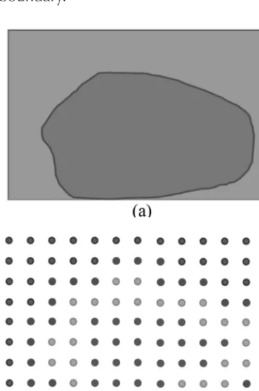
Figure 2a shows how, in a continuous space, the boundaries of the interior and exterior sets, are one-dimensional and coincide perfectly (red line). Figure 2b shows how, in the conventional digital space, each of the two sets have different boundary (exterior’s boundary is red and interior’s bound-ary is green), and that both boundaries are two-di-mensional (all the elements comprising this space are two-dimensional). These paradoxes are par-ticularly significant for image segmentation and classification when considering topological rela-tionships such as neighborhood, contiguity, con-nectivity, and boundary.
Digital image processing based on represen-tations of space that do not meet the topological axiomatic postulates (Munkres, 1999) causes fina-lly geometric algorithms are affected by paradoxes that lead to ambiguous or erroneous decisions. Se-veral important concepts for image analysis, such as the connectivity of regions, their boundaries, and the adjacency between them, are not expli-citly represented. This lack of topological aware-ness of grid-based image representation is clearly an important limitation for image analysis in com-puter environments (Kovalevsky, 1989, 2005)
[image:8.654.86.276.346.632.2]Kovalevsky (2008) performs a compendium of his proposal for the construction of a discrete geo-metry based on the Cartesian complex using the definition of topological spaces based on the axio-matic locally finite spaces provided by abstract cell complexes. His proposal seeks to provide an alter-native representation of space based on a digital topology which is not affected by the paradoxes found on conventional representations of images such as 4-connected, 8-connected and (a, b) – connected graphs (Rosenfeld, 1970; Kong & Ro-senfeld, 1991). In his work, Kovalevsky shows how Cartesian complexes allow for implementing topo-logical relations needed to perform digital images segmentation without any ambiguity. A digital spa-ce should be a locally finite spaspa-ce in which each element has a neighborhood composed finitely of several elements with various topological proper-ties. A locally finite space (LFS) is a non-empty set
Figure 2. (a) There is a common boundary a continuous space (line in red); (b) there is a “duplicated” boundary in a discrete space (both red elements and green elements).boundary and double in a conventional digital space (b)
in which each element is assigned other elements, some being finite subsets. An LFS is called an axio-matic LFS (ALFS) when satisfies the following four axioms:
Axiom 1: For each space element there are cer-tain subsets concer-taining it, which are its neighbor-hoods. The intersection of two neighborhoods of an element is also a neighborhood of that element.
Axiom 2: There are space elements whose smallest neighborhood (SN) consists of more than one element.
Axiom 3: The frontier of any subset is thin.
Axiom 4: The frontier of the frontier of a subset of an LFS is equal to the frontier of the subset.
Since the space is locally finite, there exists the smallest neighborhood (SN) for each of its elements that is the intersection of all the neighborhoods of a particular element. If one element belongs to the SN of the other, it is said that the one is incident
(IN) to the other. An incidence path (IP) between a pair of elements of a subset of an LFS is a se-quence of elements between the one and the other in which each pair of subsequent elements are in-cident. If it is possible for each pair of elements of a given subset of an LFS to find an IP entire-ly contained in that subset, it can be said that the subset is connected (CN). However, the classical topology of a space is defined if a set of subsets of S called the open subsets, satisfies the following axioms (Munkres, 1999):
Axiom C1: The entire set and the empty subset
θ are open.
Axiom C2: The union of any number of open subsets is open.
Axiom C3: The intersection of a finite number of open subsets is open.
Axiom C4: The space has the separation property. As for the axiom C4, in the case of LFSs, is only needed that for any pair of elements of the space there is an open subset which contains exactly one of the elements (axiom of separation T0). The LFS open set concept is materialized for a subset
0 when along with each element contains its SN.
When it contains all the elements of its frontier it is closed. Open subsets so defined satisfy the con-ditions of the axioms C1 to C3 and, therefore, are open in the classic sense. The SN of any element of an ALFS is open in the classic sense and is called the smallest open neighborhood (SON) of a given element of the space. All elements bounded by a given element are part of its SON. The SON of an element of the space satisfies the axiom of separa-tion (T0).
Abstract Cells Complexes
An important special case of LFS are abstract cells complexes (Listing, 1862). In this case, the space is characterized by a relationship of partial order among its elements and a function of dimension
dim (a) which maps to an element of the space a non-negative integer so that if another element
b SON (a), then dim (a) dim (b). If dim (a) = k, then the element a is of dimension (k-dimensional). An abstract cells complex (ACC) C= (E,B, dim)
is a set E of abstract elements (cells) with a binary bounding relationship B ExE which is antisym-metric, irreflexive and transitive among its ele-ments and a function dim E provided dim
(e´) dim (e´´) for (e´, e´´) B. Between two elements a and k of an ACC establishes a bounding path if it is possible to find a sequence of elements between and so that each element bounds the fol-lowing. The number of elements in the sequence minus one is the bounding path length. The sion of a complex is given by the greatest dimen-sion of all its cells. Given E´ E and B´=B (E´xE´), S = (E´, B´) is a subcomplex of C. A subcomplex will be open or closed depending on the complex from which is subcomplex.
For example, given the complex C= (E,B) where
E= the dimension function is such that dim(ei) dim(lj) with
B=
the subcomplex T= (E´, B´) with
B´´) with E´´= B´´= and the same dimension function defin-ition than before, T is open in S.
Given two subsets t and T of a space S such that
t T S, the set containing with each cell a t
also all cells of T bounding a is named the closure
of t in T denoted by CL(t, T). The set t — Fr(t, T) is called the interior of t in T and is denoted by Int(t, T). The set t — T— Fr(t, T) is called the exterior of
t in T and is denoted by Ext(t, T).
The size and shape of the SON of a cell c de-pends on the complex C with base in which this is defined and is denoted by SON(c, C). Two sub-com-plexes of a complex are mutually incidents, if any of the two contains at least one cell that is incident with any cell of the other.
CARTESIAN COMPLEXES AND
COMBINATORIAL COORDINATES
A particular case of ACC are Cartesian complexes. A complex C= (E,B) where E=
with m 1, the bounding relationship B is such that each element e1, with even index i, bounds the elements and , with odd index, is a 1-dimensional connected ACC. Here each 0-dimensional cell is closed, while each 1-dimension-al cell is open. The cells indexes are c1-dimension-alled combina-torial coordinates in the one-dimensional space.
A Cartesian ACC is obtained by performing the Cartesian product of two or more of these one-di-mensional complexes. The cells set of a -dimensio-nal Cartesian ACC Cn is the Cartesian product of n
one-dimensional connected ACC sets. The one-di-mensional complexes are the coordinate axes of
Cn which become an -dimensional space. A cell of
Cn is an n-tuple c= (a
1, a2, a3, ..., an) of ai cells
be-longing each one to a particular one-dimensional complex and becoming a component cell of c. In this case, a cell c1= (a1, a2, a3, ..., an) bounds another cell c2= (b1, b2, b3, ..., an) if for each pair of compo-nent cells ai and bi ai = bi or ai bounds bi. The di-mension of a cell is the sum of the didi-mensions of its component cells.
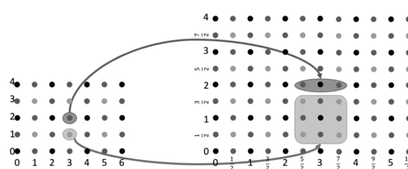
For the one-dimensional ACCs A1 =
and A2 = , figure 4 shows a possible two-dimensional Cartesian ACC graphical representations. In the figure each com-plex’s cell is represented as a point, but the cells have been differentiated by color.
Figure 3. Graphical representations of a one-dimensional connected ACC.The 0-one-dimensional cells are represented with black spots while the 1-dimensional with red dots
Source: own work.
[image:10.654.391.505.412.495.2]Figure 3 shows a possible graphical represen-tations of one-dimensional ACC of combinatorial coordinates. In the figure each complex’s cell is represented as a point, only that conveniently ap-pears the -dimensional cell with black color and the -dimensional with red.
Figure 4. Graphical representations of a
two-dimensional Cartesian ACC. The 0-two-dimensional cells are represented by black dots, the -dimensional with red dots while the -dimensional with green dots
Source: own work.
Kovalevsky defined the combinatorial balls and spheres in order to avoid “weird” complex-es (i.e. pathological cascomplex-es). For example, for the 2-dimensional Cartesian complex represented in figure 4, the subcomplex
The concept of ACC enables the definition of strange ACCs, but topological concepts such as of ball and sphere can constraint the set of valid com-plexes. These concepts are also necessary for in-creasing or reducing the granularity of Cartesian complex. To increase the granularity, the elemen-tary subdivision is used, and to reduce it, the blocks definition. The elementary subdivision (Stilwell,
1995) of a 1-dimensional cell C1, replaces it with
two 1-dimensional cells and a 0-dimension-al cell C0, so that the latter is a common face of
[image:11.654.115.514.241.406.2]the other two. In the case of 2-dimensional Car-tesian complex shown in the figure 4 elementary cell subdivision must be conducted in combina-torial way on each of its two component cells, tak-ing into account that, in general, the -dimensional cells are not subdivided.
Figure 5. Cells elementary subdivision in a -dimensional Cartesian ACC. (a) initial Cartesian complex, (b)
corresponding elementary subdivision. Red background represents the subdivision of a -dimensional cell and green a -dimensional
Source: own work.
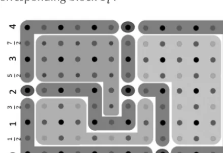
recommended to subdivide a complex in sub-com-plexes that are considered uniform with respect to some criterion in particular. The result of dividing a cell complex in blocks where each one consists of a homogeneous group of cells based on a specific criterion is called blocks complex (Rinow, 1975), (Kovalevsky, 1989). Consider a partition R of an n -dimensional complex A in k-dimensional subcom-plexes (k= 0,1, ..., n,1_ 0,i, ..., m), the subsets with
k = 0 are some representative 0-dimensional cells of A, while each of the subsets with k 0 is com-binatorially homeomorphic to a -dimensional ball. It is possible to define a complex B whose cells co-rrespond to the sub-complexes called the blo-ck complexes of A and their cells are called block For example, in a 2-dimensional Cartesian
complex, the elementary subdivision of a 2-di-mensional cell (ei, ej) origins three Combinatorial ordered for each component cell and
, here the average indexes are closed, while integers are open). This produces nine 2-di-mensional coordinates, four of them correspond to -dimensional cells, four to 1-dimensional and one is 0-dimensional as shown in figure 5. Two Carte-sian complexes C1 and C2 are combinatorially ho-meomorphic if there are elementary subdivisions of C1 and C2 so obtained complexes are isomorphic.
cell. The subcomplexes corresponding to the block cells are called blocks. Therefore, block ce-lls are elements of the blocks complex, while the blocks are subcomplexes of the original cell com-plex. Each block cell dimension corresponds to the dimension of the respective subcomplex and the
ith block with dimension m bounds jth block of di-mension m,m k, if there is in A two cell
and such that c1 bounds c2. The triplet B(A) = (EB, BR, Dim) is called blocks complex of A if there is a partition of A in subcomplexes every one homeomorphic to a k-dimensional open ball. EB is the set of block cells, each cell co-rresponds to a subcomplex called the k -dimen-sional block or k-block of A. The ordered pair (bi, bj) block cells is in the bounding relationship BR if there is in A two cells and such that c1 bounds c2. Dimension function Dim assigns to each block cell bi of B(A) the dimension of the corresponding block .
original cells complex, there are four 0-block cell, six 1- block cell and three 2- block cell in the re-trieved blocks complex.
DISCUSSION
It has been demonstrated that Kovalevsky´s (2006) alternative space representation does not arise topo-logical paradoxes. Hence, it is suggested that these alternative space concepts could be a strong foun-dation for image segmentation in computer vision. Moreover, the usage of such ALFS spaces could be explored for remote sensing image analysis. Fur-thermore, it is relevant to investigate the potential of ALFS spaces for conducting a multispectral im-age segmentation that includes topological and geometric relationships besides spectral attributes.
It was discussed that conventional methods for remote sensing image segmentation are based on digital structures that violate well-established topological axioms and geometric algorithms that assume a continuous spatial computing model. Therefore, it is necessary to conduct a research to know how combinatorial properties of ALFS could allow the involvement of topological properties so that accuracy and efficiency of multispectral image segmentation algorithms can be improved.
In particular, it is necessary to evaluate an al-ternative multispectral image representation using Cartesian complexes in order to find an efficient solution to the segmentation process that takes into account topological and geometric proper-ties. This implies to devise a conceptual model for multispectral image representation based on Cartesian complexes of abstract cells which takes into account topological and geometric properties. This can then build and evaluate a computation-al framework that enables the implementation of Cartesian complexes to adequately represent topo-logical and geometric image-objects properties used in the segmentation of multispectral images.
[image:12.654.73.293.392.543.2]The main hypothesis is that a spatial computa-tional framework, based on the axiomatic local-ly finite spaces improves the accuracy of space
Figure 6. Example of a blocks complex on a -dimensional Cartesian complex
Source: own work.
algorithms for multispectral image segmentation, since using only combinatorial coordinates es-tablished by Cartesian complexes preserves topo-logical and geometric image-objects properties.
The production of a computational framework that makes possible the representation of a digital image in a way that explicitly takes into account on topological data and uses it for digital image seg-mentation, would constitute a significant techno-logical development. It would strengthen the ability of the Engineering Faculty at Universidad Distrital to produce useful solutions to technical problems and to improve geospatial knowledge.
CONCLUSIONS
Previous work attempting to produce topology preserving image segmentation in remote sensing used digital image representations that suffer from topological paradoxes. A more rigorous proposal for addressing such problems in computer vision image segmentation was suggested by Kovalevs-ky. It was shown that ALFS meet the classical axio-matic topological postulates and hence are able to unambiguously represent adjacency, connected-ness and boundary relationships which are criti-cal for appropriate multispectral image analysis, in particular image segmentation. It is therefore re-levant and promising to conduct further in-dep-th research on in-dep-the usage of Cartesian complexes for obtaining a topologically correct image repre-sentation in order to produce more accurate and effective image segmentation algorithms.
FINANCING
This article has been done as part of the project’s research Doctoral in engineering entitled “Develo-pment of an Alternative Method for Multispectral Image Segmentation Based on Cartesian Com-plexes and Its Associated Oriented Matroids”, which was endorsed by the doctoral program in engineering of the Universidad Distrital and funded
by the University through Commission of studies granted between the period 2014I - 2016III.
REFERENCES
Arbeláez, P., Maire, M., Fowlkes, C. & Malik, J. (2009). From Contours to Regions: An Empirical Evalua-tion. Proc. IEEE Conference Computer Vision and Pattern Recognition.
Arbeláez, P., Maire, M., Fowlkes, C. & Malik, J. (2011). Contour Detection and Hierarchical Image Seg-mentation. IEEE Transactions on Pattern Analysis and Machine Intelligence (TPAMI), 33(5), 898-916. Baatz, M. & Schape, A. (2000). Multiresolution segmen-tation: An optimization approach for high quality multi-scale image segmentation. In J. Strobl, T. Blas-chke & G. Griesebner (Edits.) Angewandte Geogra-phische Informations-Verarbeitung, XII, 12-23. Benz, U. et al. Multi-resolution, object-oriented fuzzy
analysis of remote sensing data for GIS-ready infor-mation. ISPRS Journal of Photogrammetry and Re-mote Sensing, 58(3-4), 239-258.
Blaschke, T. (2010). Object based image analysis for re-mote sensing. International Society for Photogram-metry and Remote Sensing, Inc. (ISPRS), 65, 2-16. Brice, R. & Fennema, C. L. (1970). Scene analysis using
regions. Artificial Intelligence, 1, 205-226.
Brun, L., Mokhtari, M. & Domenger, J. P. (2003). Incre-mental modifications on segmented image defined by discrete maps. Journal of Visual Communication and Image Representation, 14(3), 251-290.
Cantor, G. (1883). “Über unendliche, lineare Punktman-nigfaltigkeiten V” [On infinite, linear point-mani-folds (sets)]. Mathematische Annalen, 21, 545-591. Cheevasuvut, F., Maitre, H. & Vidal-Madjar, D. (1986).
A robust method for picture segmentation based on a split and merge procedure. Graphical Models and Image Processing - CVGIP, 34, 268-281.
Cracknell, A. P. (1998). Synergy in Remote Sensing – What’s in a Pixel? International Journal of Remote Sensing, 19, 2025-2047.
de Berg, M., Cheong, O., Kreveld, M. & Overmars, M. (2008). Computational Geometry: Algorithms and Applications (3rd ed.). Springer-Verlag Berlin Heidelberg.
de Jong, S. M. & Van der Meer, F. D. (2004). Remote Sensing Image Analysis Including the Spatial Do-main. Dordrecht, The Netherlands: Springer. de Loera, J., Rambau, J. & Santos, F. (2010).
Triangu-lations: Structures for Algorithms and Applications. Verlag Berlin Heidelberg: Springer.
Felzenszwalb, P. F. & Huttenlocher, D. P. (2004). Effi-cient graph-based image segmentation. Internatio-nal JourInternatio-nal of Computer Vision, 59(2), 167-181. Grady, L. (2012). Targeted Image Segmentation Using
Graph Methods. In Processing and Analysis with Graphs: Theory and Practice, 111-140. CRC Press. Taylor & Francis Group.
Guigues, L., Ie Men, H. & Cocquerez, J. P. (May de 2001). Graphs, cocoons and image segmentation.
Third Workshop on Graph Based Representations in Pattern Recognition (GbR’2001), IAPR-TC15, CUEN. 22-31. Ischia, Italy.
Horowits, S. L. & Pavlidis, T. (1976). Picture segmenta-tion by a tree traversal algorithm. J. Association for Computing Machinery, 23(2), 368-388.
Ishikawa, H. (2012). Graph Cuts—Combinatorial Opti-mization in Vision. In Image Processing and Analy-sis with Graphs: Theory and Practice, 25-64. CRC Press. Taylor & Francis Group.
Johansen, K., Coops, N. C., Gergel, S. E. & Stange, J. (2007). Application of high spatial resolution sate-llite imagery for riparian and forest ecosystem clas-sification. Remote Sensing of Environment, 110(1), 29-44.
Knuth, D. (1992). Axioms and hulls. Berlin: Springer-Verlag. Kong, C., Xu, K. & Wu, C. (2006). Classification and extraction of urban land-use information from hi-gh-resolution image based on object multi-features.
Journal of China University of Geosciences, 17(2), 151-157.
Kong, T. Y. & Rosenfeld. (1991). Digital Topology, a Comparison of the graph based and Topological Approaches. In G. M. Reed, A. W. Ronscoe, & R. F. Wachter, Topology and Category Theory in Com-puter Science, 273-289. Oxford, U.K.: Oxford Uni-versity press.
Kovalevsky, V. A. (1984). Discrete topology and contour definition. Pattern Recognit, Lett. 2(5), 281-288. Kovalevsky, V. A. (1989). Finite Topology as Applied to
Image Analysis. Computer Vision, Graphics, and Image Processing, 45(2), 141-161.
Kovalevsky, V. A. (2001). Algorithms and Data Structu-res for Computer Topology Digital and Image Geo-metry. Lecture Notes in Computer Science , 2243, 38-58.
Kovalevsky, V. A. (2005). Algorithms in Digital Geome-try Based on Cellular Topology Combinatorial Ima-ge Analysis. Lecture Notes in Computer Science, 3322, 366-393.
Kovalevsky, V. A. (2006). Axiomatic Digital Topology. J
Math Imaging, 26(41-58).
Kovalevsky, V. A. (2008). Geometry of Locally Finite Spaces. Berlin, Germany: Editing House Dr Baer-bel Kovalevski.
Letscher, D. & Fritts, J. (2007). Image Segmentation Using Topological Persistence. Computer Analysis of Images and Patterns. Lecture Notes in Computer Science, 4673, 587-595.
Li, C. & Sun, Y. (2010). Active Image: A Shape And Topo-logy Preserving Segmentation Method Using B-S-pline Free Form Deformations. Proceedings of 2010 IEEE 17th International Conference on Image Pro-cessing, 2221-2224.
Listing, J. (1862). Der census räumlicher complexe. Abhandlungen der Königlichen Gesellschaft der
Wissenschaften zu Göttingen, 10, 97-182.
Lizarazo, I. (2014). Accuracy assessment of object-ba-sed image classification: another STEP. Internatio-nal JourInternatio-nal of Remote Sensing, 35(16), 1-22. Lizarazo, I. & Elsner, P. (2009). Fuzzy segmentation for
Munkres, J. (1999). Topology (2nd ed.). Prentice Hall. Neubert, M., Herold, H., Meinel, G. & Blaschke, T.
(2008). Assessing image segmentation quality con-cepts, methods and application. Object-Based Ima-ge Analysis. Lecture Notes in Geoinformation and Cartography, 769-784. Springer Berlin Heidelberg. Oxley, J. (2003). What is a matroid? Recuperado el
12 de abril de 2011, de Cubo 5: www.math.lsu. edu/~oxley/ survey4.pdf
Pavlidis, T. (1977). Structural Pattern Recognition. New York: Springer-Verlag,.
Pfeifle, J. & Rambau, M. (2002). Computing Trian-gulations Using Oriented Matroids. ZIB-Re-port 02-02. Berlin: Konrad-Zuse-Zentrum für Informationstechnik.
Richter-Gebert, J. & Ziegler, M. (2004). Oriented Ma-troids. En J. E. Goodman, & J. O’Rourke (Edits.),
Handbook of Discrete and Computational Geo-metry, (2da ed., 29-151). Boca Raton: Chapman & Hall/CRC Press.
Rinow, W. (1975). Textbook of topology. Berlin: VEB Deutscher Verlag der Wissenschaften.
Rosenfeld, A. (1970). Connectivity in digital pictures. J. ACM, 17, 146-160.
Saeedi, N. B. (2012). On Fully Characterizing Terrain Vi-sibility Graphs. A thesis submitted in partial fulfill-ment of the requirefulfill-ments for the degree of Master of Science. The University of British Columbia.
Schneider, M. (1977). Spatial Data Types for Database Systems: Finite Resolution Geometries for Geogra-phic Information Systems. Lecture Notes in Compu-ter Science, 1288.
Stell, J. & Webster, J. (July de 2007). Oriented Matroids as a Foundation for Space in GIS. Computers. Envi-ronment and Urban Systems, 31(4), 379-392. Stilwell, J. (1995). Classical topology and combinatorial
group theory. Springer.
Tso, B. & Mather, P. (2009). Classification Methods for Remotely Sensed Data. Boca Raton, FL: CRC Press, Taylor & Francis Group.
Urquhart, R. (1982). Graph theoretical clustering based on limited neighborhood sets. Pattern Recognition, 15(3), 173-187.
Whitney, H. (1935). On the abstract properties of linear dependence. American Journal of Mathematics, 57, 509-533.
Worboys, M. & Duckham, M. (2004). GIS: A Computing Perspective (2nd ed., 90-113). CRC Press.
Yu, Q., Gong, P., Chinton, N., Biging, G., Kelly, M., & Schirokauer, D. (2006). Object based detailed ve-getation classification with airborne high spatial re-solution remote sensing imagery. Photogrammetric Engineering & Remote Sensing, 72(7), 799-811. Zahn, C. T. (1971). Graph-theoretic methods for