A study of the parishes of Rhiw and Llanfaelrhys
1782-1947.
GRIFFITH, Margaret Jane.
Available from Sheffield Hallam University Research Archive (SHURA) at:
http://shura.shu.ac.uk/19730/
This document is the author deposited version. You are advised to consult the
publisher's version if you wish to cite from it.
Published version
GRIFFITH, Margaret Jane. (1985). A study of the parishes of Rhiw and Llanfaelrhys
1782-1947. Masters, Sheffield Hallam University (United Kingdom)..
Copyright and re-use policy
SHEFFIELD CITY POLYTECHNIC LIBRARY
POND STREET SHEFFIELD SI 1WB
Sheffield City Polytechnic Library
REFERENCE ONLY
ProQuest Number: 10697032
All rights reserved
INFORMATION TO ALL USERS
The quality of this reproduction is dependent upon the quality of the copy submitted.
In the unlikely event that the author did not send a com plete manuscript and there are missing pages, these will be noted. Also, if material had to be removed,
a note will indicate the deletion.
uest
ProQuest 10697032
Published by ProQuest LLC(2017). Copyright of the Dissertation is held by the Author.
All rights reserved.
This work is protected against unauthorized copying under Title 17, United States C ode Microform Edition © ProQuest LLC.
ProQuest LLC.
789 East Eisenhower Parkway P.O. Box 1346
A Study of the Parishes of Rhiw and Llanfaelrhys 1782-1947
M. J. Griffith
This study examines the impact of change in Rhiw and Llanfaelrhys between 3762 and 3947 with particular respect to settlement pattern and land utilisation. Anticipated character^ istics from this part of highland rural Britain requiring
confirmation included dispersed settlement, interdependent agrarian communities 3 pastoraL farming with subsistent crop growing, poor overland communications and intermittent mineral extraction. Expectations included the slow diffusion of ideas with fewer, more gradual, less effective changes occurring later than in lowland Britain. Certain additional characteristics could be anticipated due to the Welsh context.
Considerable evidence of a varied nature, including previously unpublished material has been examined. The period studied has been subdivided into five phases of approximately thirty years duration. In each phase the themes of continuity and change are examined with particular reference to settlement, economic affairs and social issues.
The evidence indicates that the dispersed settlement pattern remained a constant feature. Throughout the study period agriculture formed the basis of the local economy. The stability given by the persistence in the siting of farmhouses, of land holdings and land ownership patterns and by the gradual acceptance of appropriate innovation underpinned other fluctuations in the economy. The Enclosure Acts heralded changes in the distribution of cottages and in the occupations and social status of their inhabitants.
The impact of manganese mining fluctuated. In boom periods the influx of Englishmen brought new influences and increased earnings eased the cottagers' poverty. Later tourism became a secondary source of income. Despite these external forces, the anticipated influence of religion, education, the Welsh
language and culture combined to resist anglicisation.
A STUDY OF THE PARISHES OF RHIW AND LLANFAELRHYS*. 13^7.
MARGARET JANE GRIFFITH
A THESIS SUBMITTED IN PARTIAL FULFILMENT OF THE REQUIREMENTS FOR THE DEGREE OF MASTER OF PHILOSOPHY CM. PHIL.) AWARDED BY THE COUNCIL FOR ACADEMIC AWARDS.
SHEFFIELD CITY POLYTECHNIC
DEPARTMENT OF RECREATIONAL AND ENVIRONMENTAL STUDIES
1
vbifiKSWF
DECLARATION
I MARGARET JANE GRIFFITH BEING A CANDIDATE FOR THE DEGREE
OF M. PHIL. AS AWARDED BY THE C. N. A. A. DECLARE THAT WHILE REGISTERED AS A CANDIDATE FDR THE ABOVE DEGREE I HAVE NOT BEEN A REGISTERED CANDIDATE FDR ANOTHER AWARD OF THE C. N. A. A. DR A UNIVERSITY. SECONDLY THAT NONE OF THE MATERIAL CONTAINED IN THIS THESIS HAS BEEN USED IN ANY OTHER SUBMISSION FOR ANY.OTHER AWARD. FURTHER, THAT THE CONTENTS OF THIS THESIS ARE THE SOLE WORK OF THE AUTHOR EXCEPT WHERE AN ACKNOWLEDGEMENT HAS BEEN MADE FOR ANY
ASSISTANCE RECEIVED.
ABSTRACT.
This study examines the impact of change in Rhiw. and Llanfaelrhys between 1782 and 1947 with particular respect to settlement pattern and land utilisation. Anticipated character^- istics from this part of highland rural Britain requiring
confirmation included dispersed settlement, interdependent agrarian communities > pastoral, farming with subsistent crop growing, poor overland communications and intermittent mineral extraction. Expectations .included the slow diffusion of ideas with fewer, more gradual, less effective changes occurring later than in lowland Britain. Certain additional characteristics could be anticipated due to the Welsh context.
Considerable evidence of a varied nature, including previously unpublished material has been examined. The period studied has been subdivided into five phases of approximately thirty years duration. In each phase the themes of continuity and change are examined with particular reference to settlement, economic affairs and social issues.
The evidence indicates that the dispersed settlement pattern remained a constant feature. Throughout the study period agriculture formed the basis of the local economy. The stability given by the persistence in the siting of farmhouses, of land holdings and land ownership patterns and by the gradual acceptance of appropriate innovation underpinned other fluctuations in the economy. The Enclosure Acts heralded changes in the distribution °f cottages and in the occupations and social status of their inhabitants.
The impact of manganese mining fluctuated. In boom periods the influx of Englishmen brought new influences and increased earnings eased the cottagers' poverty. Later tourism became a secondary source of income. Despite these external forces the anticipated influence of religion, education, the Welsh
language and culture combined to resist anglicisation.
ACKNOWLEDGEMENTS.
I would like to take this opportunity to acknowledge the help which I have received from so many people whilst researching
and writing this thesis. First I wish to thank my tutor, Dr. Ralph Hebden, Head of the Department of Recreational and
Environmental Studies at Sheffield City Polytechnic for all the advice, guidance and support given over the past three years for, without that, there would have been no thesis. Secondly my thanks go to Mr. Bryn Parry, Gwynedd County Archivist, for his comments on the Welsh context of this research. Next I wish to record my thanks to the archivists and librarians of the
Caernarvon and Dolgellau offices of the Gwynedd Archives Service, the Manuscript Department at the University College of North Wales, Bangor and at the National Library of Wales, Aberystwyth, together with the officers at St. Fagans Folk Museum and the National
CONTENTS.
Title Page
Declaration Abstract
Acknowledgements Table of Contents
Xolo Lfi. oj- Tf\ cxf-S <Xt\dL \<^<*rc£.£
Table of Abbreviations
Introduction
Chapter 1: Environmental Background and Early Settlement Environmental Background
Early Settlement
Chapter 2: Conditions in 1782: Setting the Scene
Settlement and Land Ownership Economic Affairs
Social Issues
Chapter 3: The Study Area Between 17.82 and 1816 Settlement
Economic Developments Social Issues
Chapter 4: The Study Area between 1817 and 1851 Settlement
Economic Conditions Social Issues
Chapter 5: The Study Area between 1852 and 4885
Chapter 6: The Study Area between 1886 and 1914 208 Settlement
Economic Change Social Issues
Chapter 7: The Study Area between 1915 and 1947 262
Settlement
Economic Fluctuation Social Issues
Chapter 8: Conclusions 309
Bibliography 320
Appendix I: Photographic evidence 336
TABLE OF MAPS AND EIGURES MAP 1. MAP 1.: MAP 1.: MAP 1.< MAP 1.! MAP 1.1 MAP 1.' MAP 1.1 FIG 1.'
MAP 2 . ‘
MAP 2.:
MAP 2.:
MAP 2 . i
MAP 2 . 1
MAP 2. (
FIG 2.1
MAP 3.1 MAP 3.5
MAP 3.2
MAP 3. A
FIG 3.1
I. Location of the Study Area
I . Study Area: Relief and Major
Physical Features 5. Study Area: Geology i. Study Area: Soils
5. Llyn: Climatic Conditions 3. Study Area: liiater Supply and
Major Changes in Gradient
K Study Area: Prehistoric and
Medieval Sites
)• Sketch Map of Early Llyn settlement noted in Ch. 1 I. Average Monthly Rainfall
1941-1970 at Botu/nnog
I. Settlement Pattern in 1782 !. Settlement in 1782 in relation
to Soils
i. Settlement in 1782 in relation to Altitude
i. Some pre 1782 Settlements
i. Land Ownership circa 1782
i. Western Caernarvonshire: Late 18th century Communications Analysis of Distribution of Land Tax Assessment in 1782
Settlement Pattern 1782-1816 • Settlement Pattern 1782-1816
in relation to Soil
i. Settlement Pattern 1782-1816 in relation to Altitude
Communications in
FIG 3. MAP 4. MAP 4. MAP 4. 4 MAP 4. MAP 4. MAP 4. FIG 4. FIG 4.: MAP 5.' MAP 5.: MAP 5.: MAP 5.< FIG 5.' FIG 5.: FIG 5.: FIG 5.^ MAP 6.1 MAP 6.5 MAP 6.2 MAP 6.4 MAP 6.E FIG 6.1
3. Analysis of Distribution of relative Land Tax Assessment in 1818
1. Settlement Pattern 1817-1851 2. Settlement Pattern 1817-1851 in
relation to Soil
3. Settlement Pattern 1817-1851 in relation to Altitude
4. Land Ownership in the early 1840s 5. Land Utilisations 1842/1844
6* Manganese Mining in the Study Area
1. Analysis of Distribution of Rateable Assessments in 1839 2. Occupations 1831-1851
1. Settlement Pattern 1852-1885 2. Settlement Pattern 1852-1885 in
relation to Soil
3. Settlement Pattern 1852-1885 in relation to Altitude
i , Caernarvonshire Communications in
1868: Broad Gauge Railways 1. Occupations 1861-1881
2. Birth Place of Inhabitants of Rhiw 3. Birth Place of Inhabitants of
Llanfaelrhys
i. Birth Place of Married Couples in 1851-1881 in Rhiw and
Llanfaelrhys
I. Settlement Pattern 1886-1914
I• Settlement Pattern 1886-1914 in
relation to Soil
5. Settlement Pattern 1886-1914 in relation to Altitude
i . Benallt and Rhiw Mines in 1888,
1899 & 1919 i. Nant Mine in 1918
Crops 1867-1935. Oats & Potatoes
[image:13.612.154.482.64.732.2]FIG 6.
FIG 6.
FIG 6.
FIG 6.
FIG 6. MAP 7. MAP 7.
MAP 7.
MAP
7.-!. Crops 1867-1935. Barley, Turnips, Suedes
)• Livestock 1867-1935. Horses and Pigs
Livestock 1867-1935. Sheep and Cattle
i. Employment in Manganese
Mining 1886-1914
i. Manganese Output 1886-1914 Settlement Pattern 1915-1947 Settlement Pattern 1915-1947 in relation to Soil
Settlement Pattern 1915-1947 in relation to Altitude
Land Utilisation: 1932
217
222
223
243
244 263
265
267
TABLE O f :ABBREVIATIONS.
Ag. Hist. Rev.
Arch. Camb. B.B.C.S. G.A.S. Geol. Jnl. H.M.S.O.
Jnl. Ag. Soc. U.C.W. Aber.
Jnl. Hist. Geog.
Jnl. Her. Hist & Rec. Soc.
J.R.A.S.E.
Local Hist. N.L.W.
Nat. Lib. Wales Jnl. O.S.
Pers. Comm. P.P.
Prehist. Soc.
Private Poss. P.R.O.
Proc. Geol. Assoc.
Proc. Yorks. Geol. Soc.
Quart. Jnl. Geol. Soc.
R.C.A.H.
Agricultural History Review Archaeologia Cambrensis
Bulletin of the Board of Celtic Studies Gwynedd Archives Service
Geological Journal
His/Her Majesty's Stationary Office Journal of the Agricultural Society, University College of Wales,
Aberystwyth
Journal of Historical Geography Journal of the Merioneth Historical and Recording Society
Journal of the Royal Agricultural Society of England
The Local Historian
National Library of Wales
National Library of Wales Journal
Ordnance Survey
Personal Communication Parliamentary Papers The Prehistoric Society Private Possession Public Records Office
Proceedings of the Geologists Association
Proceedings of the Yorkshire Geologists Society
Quarterly Journal of the Geological Society of London
T.C.H.S.
Trans. Inst. Brit. Geog.
Trans. I.M.M.
Trans. Roy. Hist. Soc.
Trans. Roy. Soc. Edin.
Welsh Hist. Rev.
Welsh Jnl. Ag. U.C.N.W.
Univ. Wales. Unpubl.
Transactions of the Caernarvonshire Historical Society
Institute of British Geographers Transactions
Transactions of the Institute of Mining and Metallurgy
Transactions of the Royal Historical Society
Transactions of the Royal Society, Edinburgh
Welsh History Review
Welsh Journal of Agriculture
University College of North Wales, Bangor
INTRODUCTION
In this study of two rural parishes in the Llyn peninsula of north west Wales, the emphasis is upon the impact of varying
degrees of change in the settlement pattern and the land utilisation
in relation to the local cororounity (See Map 4,4,). The study area exhibits certain characteristics which need to be considered in the context of the wide range of both former and present-day patterns of rural settlement and land use found across Britain,
Several zones have been identified by various authors, each being characterised by recognisable features such as the predominance of nucleated villages, hamlets or dispersed homesteads (4). The Llyn peninsula was placed by Thorpe within the category which has a close to medium density of scattered homesteads with occasional villages and market towns (2). This is but one of a variety of models which have been suggested to categorise regional settlement contrasts within Britain. In the highland/lowland concept presented by Fox, the eastern edge of paleozoic outcrops formed the boundary between these two settlement zones (3). This concept is recognised now as being too simplistic and has been elaborated to take into
account the interacting elements of those physical, economic and cultural factors which, operating over time, produce particular kinds of settlement patterns and land uses £4).
Regional patterns of land use are related to a range of
physical factors. The combination of altitude, rainfall and the length of the growing season results in contrasting regional climatic conditions which correlate closely to contrasts between
A
nucleated and dispersed settlement forms (5), . The Llyn peninsula
North Wales. (See Maps 1.5. I-yi). The variety of relief, rocks and soils together with the climatic differences resulting from altitude, exposure and location superimposes constraints on the
character of Llyn farming which in turn.affects the settlement pattern (6).
The physical environment determined former economic patterns, many of which became integrated with the historic and cultural factors which then affect later development. These
influences are shown in the farming regions which have been identi fied in England and Wales by Thirsk and Emery (7), The Llyn
peninsula is within the "mixed farming lowland" category. However the relatively high proportion of upland unenclosed at the end of the eighteenth century and the effect of overland isolation near the extremity of a mountain-locked peninsula' are additional
features of the physical and economic influences within the study area which might modify .this categorisation.
In Wales, continuity of culture and language is said to be a basic and recurrent theme influencing the pattern of rural
settlement (8). Four major cultural factors are recognised by Thomas as having contributed to the evolution of contemporary rural land scapes in Wales. These are the sub-divisions of pre-medieval tribal society, Anglo-Norman feudalism, the land enclosures of the eighteenth and early nineteenth century and the influences of the Industrial revolution (9). Within the study area these are closely interrelated as shown by the pre-medieval and monastic patterns of
extraction, from these two rural parishes, of the vast majority of British Manganese ore, is however expected to be an influence for change rather than continuity.
Study of the interrelated effect of physical, economic and cultural factors over time highlights the problems within the
concept of continuity and/or change C10). Continuity of territorial organisation and occupation, and the survival of population and language are probably more likely in districts such as the study area, and some evidence is presented to support this. Continuity of specific site occupation, of settlement pattern and land use is less likely when these aspects of a neighbourhood are continually modified to meet the changing social and economic factors such as population size and market forces. The combined effects of a
growth in population, of squatter settlements, the opening of
quarries or mines and the spreading influence of Methodism produced districts where apparently peripheral settlement areas and isolated chapels were part of a web of physical, economic and cultural
factors which gave an underlying unity to the community not observable by focussing merely on the morphology of settlement, and which were also influences ^or change (1.1).
In this study aspects of the cultural influence of
education and religion upon the rate of change and the development of the community are investigated as an important- backcloth to the main themes uf land use and settlement pattern. The potential to examine the effects of variations in farm size and tenure between a large compact estate-owned farm* a fragmented owner^occupied
farm and a squatter smallholding exists.but is not developed;
narrow as the factors within the study area during the period 1782 to 494-7 which are thought important to the processes jpain^ taining continuity or assisting change could be very varied.
A wide range of eyidence has therefore been studied and selection has taken place to. illustrate the two main themes. This includes government-initiated surveys, reports and censuses, authoratitiye
works on particular aspects or periods of time, estate papers and maps, and the'recollections of many local people past and present.
Previously unpublished material has been used, particularly concern ing manganese mining and local social conditions, and considerable fieldwork has been undertaken. Appendix I contains a selection of photographic evidence and Appendix II enables identification of each site mentioned in the text.
The balance between the interacting components which constitute the situation in a given district changes over time as between varying degrees of innovation and stability. For this
reason the period under review in this study is subdivided historically into phases of approximately thirty years and the salient variables are described and analysed phase by phase to demonstrate this varying relationship.
INTRODUCTION - REFERENCES.
(1) Thorpe, H. (1964) Rural Settlement, pp.370-1; in Uatson Old & Sissons SB.
The British Isles, A Systematic Geography.
Roberts, B.K. (1977) Rural Settlement in Britain p.15.
(2) Thorpe, H. (1964) op. cit. pp. 360-1. (3) cf. Fox, C. (1952) The Personality of
Britain.
(4) Roberts, B.K. (1977) op. cit. p.17.
(5) Gregory, S. (1954) Accumulated temperature maps of the British Isles, p. 257- p.262 in Trans. Inst. Brit. Geog. 20.
Gregory, S. (1964) Climate p.59, p.70 in hJatson 3U & Sissons 3B.
The British Isles, A Systematic Geography. (6) Roberts, B.K. (1977) op. cit. p.19.
(7) Thirsk, 3. (1967) The Agrarian History of England and Wales.
IV: A.D. 1500-1640. p.4. and p.128. (8) Thomas, 3.G. (1957) Settlement Patterns:
Rural, p.141 in Bouen E.G., biales. (9) Idem. pp. 141-2.
(10) Roberts, B.K. (1977) op.cit. p.78. (11) Thomas, 3.G. (1957) op. cit. p.154. (12) Dennis, R. (1984) Historical Geography:
Theory and progress.
MAP 1.1: L OCATI ON OF THE STUDY AREA
WALES
Ll y n
N
Irish Sea
Ne f yn
P w l l h e l i
Llyn
Porth ' Neigwl Aberdaron
(?
B a r d s e y I s l a n d
C a r d i g a n Bay
KEY
P a r i s h of Rhi w
CHAPTER ONE
ENVIRONMENTAL BACKGROUND AND EARLY SETTLEMENT
I. ENVIRONMENTAL BACKGROUND.
The natural environment of any district requires investigation and
explanation if the effect of man upon it is to be analysed appropriately. The geological structures and the presence of glacial drift or other quaternary features greatly affect the relief, coastline, waterways and soil types within any area (l). The climatic factors of rainfall, wind, sunshine and temperature combine to determine optimum, growth periods, vegetation cover, flora and fauna (2). Man, through
observation, trial and error, and accumulated wisdom, has exploited
certain features of the natural environment and has attempted to modify others in order to meet his basic needs and, if possible, provide a surplus for profit.
In this chapter the physical background of the area under review is studied in order to place the efforts of generations of men in their natural context.
The study area comprises the parishes of Rhiw and Llanfaelrhys
which lie on the southern side of the remote Llyn peninsula of Gwynedd in
North West Wales, about eight miles east of its tip. (See Map 1.1.). A major physical feature is a central ridge which runs North - South
MAP 1.2: STUDY AR EA : RELIEF AND MAJOR PHYSICAL FEATURES
Rhoshirwaun
1 0 0
Y Graig [Gy If in Ir
Porth N e i o w I YfRhuol
KEY
Mynydd y Graig
Par ish bo undar y M a n g a n e s e mines INant y
Gadwei By tllith C. G. Creigiau Gwineu A lt it ud e shown e v e r y 100
I I Mynydd enarfynyddj
Kms
of Mynydd Penarfynydd. To the east of the central ridge the land falls
away steeply to a plain of glacial drift at around 150 feet above sea
level, whereas to the west and north the transition to an undulating
drift covered lowland lying at around 300 feet is less sudden (3] (See
Map 1.2. and Appendix I. Nos. 1, 2 and 6.).
The sea marks the southern boundary of the study area. The coast
line is varied with the westerly rocky cove of Porth Ysgo near the mouth
of the gorge of Nant Y Gadwen, and the easterly manmade boulder cleared
harbour of Y Rhuol and the treacherous sands and high clay cliffs of
Porth Neigwl offering the only landing sites. Between these the rocky
headlands form high rugged cliffs (4] (See Map 1.2.& Appendix I. Nos.8 & 14).
This landscape is a product of the underlying geology, modified by
the considerable cover of glacial material and combining with a variety
in altitude, aspect, gradient of slope and soils to produce a highly
varied terrain.
The geological structure of the Llyn peninsula is complex (5)
(See Map 1.3.). In outline, the whole area coincides with a downfold
of Ordovician rocks compressed between two upfolded belts of older
Precambrian rocks in the north and west and Cambrian rocks in the south
and east (6). These Ordovician rocks are in large part Igneous in
origin, relatively resistant to denudation and therefore form the
highest ground (of. Mynydd Rhiw.). A tract of Precambrian rock occurs
A
in Llyn between Nefyn and Bardsey Island, and its eastern boundary lies
partly within the study area (?) (See Map 1.3.).
The Ordovician exposures within Rhiw and Llanfaelrhys parishes are
of the Arenig and Llanvirn Series and include sedimentary rocks and
both extrusive and intrusive volcanic products (8). All three rock
types have greatly affected developments in the study area. The
sedimentary Hirundo zone of the Arenig Series contains manganese ore (9).
MAP 1.3: STUDY AREA: GEOLOGY
t h i ck
g l a c i a l
dr i ft
w
Miles
Precambrian - Mona Complex j— J Ordovician - sedimentary
rocks v w Manganese beds
I H Contemporaneous lavas □ Intrusive rocks
and to the west of Clip Y Gylfinir (See Map 1.2.). The multiple effect of manganese mining upon the community is described in later chapters. Alternating with these less weather resistant deposits of
shales, grits and mudstones is a variety of acid and basic extrusive igneous material part of which forms the large basic masses of Mynydd
Penarfynydd, Creigiau Gwineu and Mynydd Y Graig (10).
The intrusive sills east and west of Porth Ysgo overlie sedimentary rocks and may have afforded the resistance required to allow the
differential coastal erosion and thus the resultant cove with its later strategic importance (ll).tSee Appendix I. Nos. 4 3 & 44).
Differential aerial erosion shownby the north-east / south-west
ridges of volcanic rock on Mynydd Rhiw provide a variety of shelter from the elements for animals grazing at this altitude (12).
The columnar jointing in much of this volcanic material was a boon to those involved in the building of houses and field walls especially in the early nineteenth century (13). The exposures below Creigiau Gwineu were also used as a quarry, and Y Graig was another source of building stone (14).
The geological features of the district were much faulted, possibly due to the proximity of the boundary with the Precambrian Monian rocks.
The effects of these earth movements include the formation of the fault across the central ridge in the position of the main col, and the
mineralisation and disturbed formations of the manganese beds (15).
A
In Llyn the dominant product of the long continued erosion of the Tertiary era was a series of gently undulating dissected plateaux • transecting indifferently rocks of all ages, above which stood the Monadnock hills including Mynydd Rhiw (16).
A
Whittow, in his geomorphological study of Llyn, notes examples of
provide ideal situations for house sites (18).
The quaternary succession in Llyn was complex and the resultant covering of drift over much of the study area has been one of the chief determinants of soil type, drainage and minor aspects of local relief. These have greatly affected settlement and land utilisation patterns
since prehistoric times (19).
The main Irish Sea glaciation (Wolstonian) completely overran the Llyn peninsula, deflecting the Welsh ice stream to the south (20). The whole of the study area would therefore have been engulfed by ice from the Irish Sea basin to the north, and this accounts for upland areas of drift and glacial straiae (21).
During a later (Upper Devensian) Irish Sea glaciation it would appear that neither the Irish Sea nor the Welsh ice had the power to
A
override areas of high land in south west Llyn and the study area would therefore have been subjected to periglacial conditions (22). This may well account for the tor-like frost shattered scarp of Creigiau Gwineu
and the scree slopes along parts of Mynydd Rhiw and Mynydd Y Graig (23). There is debate concerning the south western limits of the Devensian advance of the Irish Sea ice; it may have abutted against the western lower slopes of Mynydd Rhiw and have extended south to Porth Ysgo (24). The deep gorge of Nant Y Gadwen and some other local streams probably
developed as glacial melt water channels, influencing later drainage patterns, and, in Nant Y Gadwen, exposing bedrock containing manganese ore (25).
Thus the whole study area had been covered at least once by glacial drift originating from the Irish Sea basin to the north. This northern ice had moved across the area from NNW to SSE depositing calcareous tills, sands, clays and gravels with many small erratics including flint (26).
MAP 1.4: STUDY AREA: SOILS
and the soil types found within the study area. The formation of the soil of any area is dependent on the combination of the solid geology,
superficial deposits and climatic conditions (27). Variations of soil type usually correlate closely with local agricultural practice in land utilisation and land management and thus indicate areas for potential development (28). Within the parishes of Rhiw and Llanfaelrhys the characteristics of the soils vary considerably (See Map 1.4.).
Either side of the central Mynydd Rhiw ridge the lowlands are
covered by a deep mantle of glacial drift. This boulder clay contains material presumed to be of northern origin, including carboniferous
chert, limestone and triassic minerals (29). These clays mainly comprise
the soils of the Dinas series, a poorly drained non-calcareous gley, whilst there are some patches of the very poorly drained peaty gley of
the Merin Series, in the north-west of the study area, bordering on the former wastes and frequently waterlogged commonland (30).
The characteristics of the soils of the upland ridge contrast strongly with those of the lowlands. The freely drained brown earths are known to frequently underlie areas of highest agricultural potential.
In the study area these brown earths are represented along the upland ridge by .the soils of the Rhiw, .Madryn and Cadlan series (31). The parent material of the very fertile Rhiw series is the drift and basic igneous rock of much of the central upland ridge. It has been demonstrated that these doleritically derived soils carry twice as many sheep per
acre than, soils on Rhyolite under similar rainfall. Where it occurs with a deep profile, this is a most agriculturally attractive soil (32). However some parts of the Mynydd Rhiw ridge are rock dominant and no soil profile has been able to develop. (.See Appendix I. Nos. 4 & 2).
and igneous rocks from the underlying Ordvician rock. These form low base status^freely drained soils suitable for arable cultivation, as do the soils of the Cadlan Series which are formed from the Northern
Boulder clay drift and which occur in ribbon-like stretches on the western flanks of Mynydd Rhiw just above the lowland with its gley soils (33). These lighter^better drained soils tend to warm up more quickly in spring and summer thus producing young grass earlier and, as freely drained loams, are usually suitable for cultivation. They are however liable to occasional seasonal drought (34).
The exposed western coastal situation of the study area results in the district benefitting from a relatively mild moist climate (35). CSee Map 1.1). The prevailing westerly and south westerly winds are
responsible for both the relatively mild winters and the average of
30 days a year with gales (36). Within the study area the proximity of the sea minimises the range of both diurnal and annual temperatures (37).
The effect of altitude, aspect,the cooling effect of the wind on the exposed western slopes and the limited sunshine hours on the steep eastern slopes would cause marked but very local variations in duration and strength of sunshine and in temperature (38). The length of the frost free season also has a close correlation with altitude and affects
the length of the growing.season and thus agricultural activity (39).
A
In Llyn the mildness beneficially affects plant growth in comparison
with much of Wales (See Map 1.5.ijii). The coasts of Caernarvonshire receive more sunshine and less cloud than the uplands (See Map-iS.iii) The periods of low cloud over the upland of Mynydd Rhiw causes additional variations within the study area.
The passage of cyclonic storms and the moisture laden prevailing south westerlies drench the uplands of Snowdonia whereas the coastal
A
MAP 1.5: LLYN: CLIMATIC CONDITIONS
( i ) Mean dates for st art of the ( I I ) Mean dates for first and last air growing season. 1 9 1 1 - 1940 f r osts. 1911 - 1940
15 March 15 March - - - First
— Last 28 Feb.
1st March
1st Dec. 15 Dec.
Source: W. Davies Wales in the Early Middle Ages
( i i i ) SUNSHINE ( i v ) ABSOLUTE DROUGHTS Average annual hourage Gr eat est number In a year of bright sunshine 1450 1906 1940
1500
1450
1500
Source: E.G. Bowen Wales O. 572 1953 H.M.S.O
( v ) SNOW LYING ( v l ) RAINFALL
Annual average of mornings with Annual average rainfall in inches snow lying, 1912 1938
50 +
5 - 1 0 4 5 - 5 0 ' 50 Under 5
4 0 - 4 5 <0
Under 40' m
40
40
40
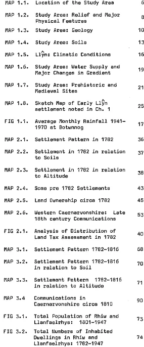
FIGURE 1.1: AVERAGE MONTHLY RAINFALL, 1941
-130
120 -|
110
100
Rai nf a l l go •
8 0
-70
ln 6 0
50 H
40
mi l l i me t r e s 30
20
1 0
-AT BOTWNNOG
2 miles N.E. of study a r e a
1---1---1---1---1---1---1---1---1---1
----J F M A M J J A S O N
Mon t h
Altitude: 1 1 2' O.D.
AVERAGE ANNUAL RAINFALL: 1,099mms
S o u r c e : W a l e s W a t e r A u t h o r i t y G w y n e d d D i v i s i o n
1 9 70
[image:33.620.42.548.60.752.2]ridge of Mynydd Rhiw receives an annual average of 100 -110 cms., whilst the lowlands to the lee of the ridge enjoys a lower annual
average total of under 100 cms. (See Map 1.5.Vl).
The seasonal distribution of rainfall is typical of western Europe
with October, November and December being the wettest months and
May, June and July usually being the driest months, although March and April have low rainfall in western Llyn.(41) (See Figure 1.1.}.
This seasonal variation is associated with the hay harvest of June and July and the corn harvests of late August and early September. The annual average number of raindays is 175 - 200 (42).
The ridge of Mynydd Rhiw is subject to frequent periods of low cloud, causing reduced sunshine and reduced evaporation. Snow cover is rare (See Map 1.5,- V.). Over a 35 year period, absolute drought was
A
recorded in Llyn on average once every four years with the maximum of
four droughts within any one year (43)(See Map 1 .t^jy).
The distance from an adequate water supply is a crucial factor in determining both settlement sites and land utilisation in any district. When considering the water supply, the district under review can be divided into two areas. Firstly, the central upland ridge which
includes the head waters of only one stream, and where the water supply
was obtained from natural springs and two main wells,(See Map 1.6-.)• In 1947, at the end of the period under review, this area was still without a supply of piped mains water, and all water was still obtained from the wells and various springs. This had complications for land use in that during the periods of drought cattle had to be moved nearer adequate supplies of water, and also for the manganese operations in that the ore wets' washed in a field still known as 'Cae Mango1
MAP 1.6: STUDY AREA: WATER SUPPLY AND MAJOR CHANGES IN GRADIENT
/ /
'/n\
•C a e * ' M b n g oy
Major changes Spring
Well Wate r supply River
Secondly, the lower land to the east and west of the central ridge,
which was drained by several small streams and was also supplied by wells dug at most of the old farms. Some of these streams were
tributaries of the Afon Daron and flowed away to the west; some joined the Afon Soch, flowing to the east (44). Three short streams flowed
south through rejuvenated overdeepened glacial meltwater channels, tumbling over cliffs to reach the sea (45).
There was sufficient headwater on two streams to enable corn mills to operate, one having existed at least since the fourteenth century (46). None of the streams were of use as sources of fish, nor in assisting with transport in any way. Much of the lowland was dissected by numerous ditches in an attempt to drain the heavy gley soils. These areas were often suitable for summer cattle grazing and as hay meadows.
To the south, the sea was a source of food, fish being used to
augment the diet. It was also an important means of transport and travel. The coves of Porth Ysgo and Y Rhuol were relatively sheltered from the prevailing winds and were of much value to the local community.
II. EARLY SETTLEMENT.
It was probably a direct result of this prominent coastal position, with easy access from the sea, that the study area was first inhabited, rjiost likely by groups of people wandering through and then settling in the region in pre-historic times.
Wherever man settles he modifies the natural environment in his desire to better meet his basic needs for shelter, water and food. Religious and cultural, ritual and territorial rights are frequently expressed in ways which further modify his habitat. The evidence
MAP 1.7: STUDY AREA: PREHISTORIC AND MEDIAEVAL SITES
Pla s y n Rhiw / X *
B odwyddog
KEY SITES
M e sol i thi c blade N eo l it h ic ax e f a c t o r y N eo li th ic ch am be r ed
tomb
Cairn
S t a n d i n g s t one C i n e r a r y orn E n c l o s u r e s / f or t s Pena rf yny dd
Hut
P l a t f or m house Known e x t e n t of f i e l d sy s te ms Par ish bo un dar i es
K m s 600 c o n t o u r
Church
area takes several forms and indicates his presence periodically, if not
continuously, from Mesolithic times onwards (47). (See Map 1. 7..).
It seems probable that in prehistoric times travel was easier by sea than across forested, rocky or marshy land, and that the Irish Sea, with its surrounding coastal fringe formed a cultural entity (4g)..
a
This focus would have given the promontory of Llyn more significance than it appears to have when viewed from the later cultural epicentre of
S.E. England. The treacherous sea passage around the western extremity of Llyn may sometimes have been avoided by the traversing of the neck of
A
the peninsula. The height of several of the Llyn hills would have
enabled travellers to take bearings on landfalls in Ireland and S. Wales. Thus, over the millennia many groups may well have visited the study
area.
A retouched flint blade, possibly Mesolithic was found in Nant Y Gadwen, a sheltered stream valley within quarter of a mile of a sandy cove: an appropriate location for people from a hunting - fishing
economy (49). An established local society is suggested by the e x i s t e n c e
of the Neolithic Megalithic Chambered tombs of Tan Y Muriau and
Bronheulog (50). The circular nature of Rhiw churchyard may indicate the site of an additional monu^ment. The Mynydd Rhiw Neolithic stone axe factory is on the border of the study area, and roughed-out and polished axes from this site have been found both locally and at a
considerable distance, probably indicating industry, trade and travel (51). Bronze Age cairns occur on Mynydd Rhiw and two standing stones
remain near Capel Tan Y Foel (52). A Cinerary urn with a bronze awl and pommel was uncovered near the col in the Mynydd Rhiw - Mynydd Y Graig ridge (53). Together these again indicate an organised society with communal activities (54).
found ringing the central Mynydd Rhiw - Creigiau Gwineu ridge [55).
Areas of cultivation and a variety of hut types occur either side of this ridge; in particular the eastern side shows signs of extensive field systems resulting from prolonged early cultivation on prime agricultural land within the study area (56). Archaeologists now
consider that in some such areas cultivation may have begun in Neolithic
times (57).
A
The earliest surviving documentary reference to Llyn is in Ptolemy's
A
Geography where Llyn is named as the Ganganorum Promontorum, the
promontary of the Gangani, who were one of the tribes of Iron Age Ireland (58). In origin the name Llyn is related to that of the Irish province of Leinster, again stressing links with Ireland (59). The use
of Ogam in the Llystyn Gwyn Inscribed Christian Stone of the fifth -sixth centuries A.D. testifies to the persistence of Irish influence in North West Wales (60). Closer to the study area the fifth - sixth century A.D. inscriptions on the two memorial stones from Capel Anelog near Aberdaron indicate the presence of an ecclesiastical community, possibly the nucleus of the later 'das' at Aberdaron (61). These probably represent the early establishment of Celtic Christianity in
the district in the form of a religious community at Aberdaron (62). In spite of later medieval rededications by adherents of the Roman
A
Catholic Church, the percentage of Celtic dedications in Llyn churches is very high, reaching 77°/o (63). This re-emphasises the central
A
included part of the study area (6 6).
Following the English Conquest of Wales by 1284, the medieval bond townships and areas of common became Crown land (67). Thus within the area under review the poor agricultural..land of the marshy inland
waste of Rhoshirwaun and the rocky upland ridge of Mynydd Rhiw and Mynydd Y Graig became Crown commons. The bond township of Penarfynydd, which contained rich agricultural land, also became Crown property and was later leased to favoured subjects (6 8). Differential development
was therefore already occurring upon the variety of soils and terrain
within the study area.
The Extent of Caernarvonshire describes the nature of the townships, their inhabitants and certain local duties and taxes (69). It indicates early settlement sites within the study area.
The development of several of these into the substantial farms in
the period under review is noted in Chapter Two.
Within the former free townships in the study area sites of several platform houses and their associated field systems overlie some of the earlier cultivation tracts already described (70). It is thought that the platform house sites may indicate those early medieval homesteads which were not sufficiently successful to remain in use and be modified by following generations. They mainly occur in land which later formed part of the Plas Yn Rhiw estate and their fossilised state may indicate an early change in land management within that estate.
The church lands of the Monastery of Bardsey became Crown property
after the Dissolution of the Monasteries in 153(?% Much of this land was
A.
acquired gradually by the local -Sfjuirarchy including the Llyn families
of Bodwrdda, Carreg, Bodfel and those families at Meillionydd, Methlan Nanhoron, Cefn Amwlch and Brynodol [7-) l . (See Map 1. q. ). Within the
MAP 1.8: SKETCH MAP OF EARLY LLYN SETTLEMENT NOTED
IN CHAPTER 1
Nefy n
Bodfel Brynodol
Cefnamwlch Pwllheli
Nanhoron Methlem
Carre Mellllonyd . Bodwrdda Aberdaron./
Bardsey Island
Miles
KEY
a Centres of population • Squires of West Llyn * Early inscribed stones t~~l B ar dsey’ s monastic land
[II
Study areaproductive undulating lower land to the west of Mynydd Rhiw ridge.
The pattern of widely dispersed settlement was therefore already
apparent in the sixteenth and seventeenth centuries. It resulted from the development of the Crown-owned bond' land, the gwelyau Df the
free townships and the consolidation of the former monastic hamlets and produced a pattern of widely scattered homesteads across all but the Crown commons.
Thus since Mesolithic times, man has selected those aspects of the natural environment within the study area which he has perceived as
best meeting his needs. The patterns of later use have been superimposed upon the signs of earlier settlement and land use, so that incomplete evidence remains where the earlier work was too substantial to remove, or when it occurred in areas not requiring modification to meet later needs. Some monuments became incorporated into later features and a few have been discovered as chance finds.
When the size of the population grew or the climatic conditions improved, settlement became more dense and cultivation extended into higher altitudes. Periods of centralized management, by Abbot, Prince, King or later landlord would also have modified both settlement and land
CHAPTER ONE REFERENCES.
Cl) Howe, G.M. (1957) Weather and Clirpate. p.57 in Bowen, E,G, (ed) Wales,
(2) North, F.J., Campbell, B,, Scott, R..(1949) Snowdonia p.108;
McConnell, P. (1922) The Agricultural NotebooK, pp. 96-^7; Ball, D.F., (1964) Soil Classification, Land Use and
Producity, Welsh ..Soils Discussion Group p.4.)
(3) Ordnance Survey. 1: 25000 First Series. Sheet SH 22; Whittow, J.B. (1957) The Lleyn Peninsula, N. Wales.
A Geomorphological Study. Unpub, Ph.D. Reading, pp. 62-63,
(4) Millward, R. and Robinson, A, (1978) Landscapes of North Wales p. 39.
C53 Cattermole, P.J. and Romano, M. L1981) Lleyn Peninsula, Geologists Association Guide. No. 39. pp. 1 - 4 ,
(6) Smith, B. and George, T.N. (1961), North Wales, British
Regional Geology p.1.
[7 3 Idem, p. 7;
Matley, C.A. 11932) Geology of Mynydd Rhiw and Sarn Quart. Jnl. Geol. Soc. P. 250;
Matley, C.A., Nicholas, M. and Heard, A. (1939) Geological Field Meeting to Western Lleyn in 1938, Proc, Geol. Assoc, p. 99;
Roberts, B. (1979) The Geology of Snowdonia & Llyn. p, 8
and p. 55.
(8) Smith, B and George, T.N, (.1961) op.cit. p, 29, p. 31,
C9) Matley, C.A. (1932) op.cit. pp. 248, 249,
C11)
d 2) (13) 114) (15) (16) 117) (18) (19) (20)
(21)
C22)
Smith, B and George, T.N. . (.1961). op.cit, p, 29;
Ball, D.F. (undated) Lleyn Peninsula, Soil Science Excursion. p,1,
Hatley, C.A. C1932). op.cit. p. 244;
Cattermole, P.O. and Romano, H,, C1984), op.cit, p. 9,
Roberts, B., (1979). op.cit. p. 57.
GAS. XL/EA 1811. Aberdaron etc. cf. rights for obtaining stone.
Hatley, C.A. (1932) op.cit, p. 247;
Yale a Hardcastle, Pwllheli. Cunpubl,) Nanhoron Papers of 1905 & 1911;
Pers. comm. G. Jones Hoelwyn View, Rhiw
Smith, B., and George, T.N. C1961). op.cit. p,42;
Challinor, J. and Bates, D. C1973) Geology Explained in
North Wales, p. 26.
Smith, B. and George, T.N, C1961) op.cit, p, 2 a p. 78^80.
Whittow, J.B. C1957) op.cit. V.5 - 18.
For example: Bwlch Clawdd, Gwelfor, and around Ty’n Y Graig. Johnson, N. (1976). An Environmental Study of the Location of Pre Hedieval settlements in Caernarvonshire.unpubl. H.A,
Sheffield, pp 216, 217.
Bowen, D.G). (1973). The Pleistocene History of Wales a the Borderland. Geol. Jnl. p. 208;
Saunders, G., (1968a). A Reappraisal of glacial drainage phenomena in the Lleyn Peninsula.Proc. Geol. Assoc, p. 331. Bowen, D.Q. (1977) The Land of Wales, p. 27; in Thomas, D,
Ced) Wales: A New Study.
Bowen, D.Q. (1973). op.cit. p. 208.
Peake, D.S,, Bowen, D,Q,, Hains, B.A., Seddon, B, . [4 973) Wales, p. 62;
Saunders, G U968b) A Fabric Analysis of the ground
moraine deposits in the Lleyn Peninsula of S.W, Caernarvon- shire. Geol, Jnl. P, 406.
C233 Whittow, J.B., and Ball, D.F. 0)970) North West Wales. p. 28 in Lewis, C.A. ted).The Glaciations of Wales and adjoining regions.
Synge, F.M., .0964) The Glacial Succession in Western Caernarvonshire Proc. Geol. Assoc, p. 439,
C24) Bowen, D.Q., 0973) op.cit, p. 238;
Whittow, J.B. and Ball, D.F,, 0970) op.cit, p. 42;
Saunders, G. 0968a) op.cit. p. 338. [253 Idem. p. 320.
C26) Jehu, T.J. 0909) Glacial Deposits in Western Caernarvonshire.
Trans. Roy. Soc. Edin. p. 46 and p.62;
Whittow, J.B. and Ball, D.F. 0970) op.cit, p,42;
Gresham, C.A. (1949) Early Settlement Sites in Lleyn tunpubl),
C27) North, F.J., Campbell, B., Scott, R. teds) 0949) op.cit. p.408;
McConnell, P. C4922) op.cit. p. 96 and p.97;. C28) Ball, D.F. (1964) op.cit. p.4.
C29) Ball, D.F., pers. comm., Soils and Agriculture of the Lleyn Peninsula, p.8.
[30) Idem. p.8;
Bowen, E.G. 0957) op.cit, pO07. [31) Johnson, N. 0976) op.cit. p.216;
Bowen, E.G. 0957) op.cit, p,99;
Progress Report 4935-8, South Caernarvonshire, Welsh Jnl, Ag. pp.272-285i
C32) Johnson, N. (.4976) op.cit, Appendix 5, Soil, p,248;
Bowen, E.G. C4957) op.cit, p,444, (33) Johnson, N., C4976) op.cit, p,247
(34) Jones, G.R.J, C4963) Early Settlement in Arfon: The Setting of Tre'r Ceiri. T.C.H.S, p,3.
C35) North, F.J., Campbell, B., Scott, R, C4949) op.cit, p,449; The writer is aware of the increasingly limited number of
/\
meteorological stations within Llyn upon which data is based, (36) North, F.J., Campbell, B., Scott, R. (4949) op.cit, pp.446-7. (37) Davies, B.L. (4977a) Temperatures, p,27 in Bassett T.M.
& Davies, B.L.^Atlas of Caernarvonshire.
(38) Davies, B.L. (4977b) Sunshine, p.29; in Bassett T,M, & Davies, B.LV Atlas of Caernarvonshire;
North, F.J., Campbell, B., Scott, R, C4949) op.cit, p.446;
Howe, G.M. (4957) op.cit, p.75.
(39) Davies, W. (4982) Wales in the Early Middle Ages, p,8,
(40) Lamb, H.H. (4965) The History of our Climate; Wales, p.45 in Taylor, J.A. Ced) Climatic Changes with special reference to Wales and its Agriculture.
(44) Davies, B.L. (4977c) Rainfall.p.23 in Bassett, T.M, and Davies, B.L. Atlas of Caernarvonshire.
(42) H.M.S.O. (4952) M.O. 488 Royal Meteorological Society. Rainfall Atlas of the British Isles.
(43) Idem.
(44) Whittow, J..B. (4960) Some comments on the Raised Beach
(45)
(46) (47) (48)
C49D
(50)
(53 3
(52)
Bowen, E.G., (39573 op.cit, p.33;
Miller, A.A. (39433 Pre Glacial Erosion surfaces.round the Irish Sea Basin. Proc, Yorks, Geol, Soc, pp, 43^42;
Saunders, G, (3968a3 op,cit, p,334.
Ellis, H. (3 838) The Record of Caernarvon. R.C.A.13, (3964) Caernarvonshire 111, p,300-306.
Watson, K. (3965) Regional Archaeologies. North Wales, p.36,49;
Bowen, E.G. (3968) The Seas of Western Britain; Studies in Historical Geography, p.357; in Geography at Aberystwyth;
Bowen, E.G. (3970) Britain and the British Seas pp.33,44, in Moore, D. The Irish Sea Province in Archaeology and History,
Griffith, M. (3983), Archaeology in Wales p,34;
Palmer, S. (3977) Mesolithic Cultures of Britain, p,48; Wainwright, G., (3963) A Reinterpretation of the Microlithic
Industries of Wales.Prehist. Soc, p.326;
Ridgeway, M.H. (.3946) Prehistoric Flint Workshop near Abersoch.Arch. Camb. p.80.
Savory, H-I\l. (3980) The Neolithic in Wales, pp,232-237; in Taylor, J.A. (Ed), Culture & Environment in Prehistoric
Wales}
R.C.A.H.M. (3964) Caernarvonshire III,Monuments 3755, 3756, Holder, C. (3963 ) The Excavation of a Neolithic Storie
Implement Factory on Mynydd Rhiw in Caernarvonshire, The Prehistoric Society, pp. 335-6;
R.C.A.H.M. (3964) Caernarvonshire III, Monument 3535,
Idem. Monuments 3753, 3754;
(53) R.C.A.H.M- (4964) Caernarvonshire III. p. XXXIX. No.32
(54) Burgess, C.B. (4980) The Bronze Age in Wales, p.245
in Taylor, J.A. Ced) Culture and Environment in Prehistoric
Wales
(55) R.C.A.H.M. (4964) Caernarvonshire III. Monuments Nos.3744 4742, 4743, 4 536.
(56) Idem. Monuments No. 4744-4750; Johnson, N. (4976) op.cit. p.84 (57) Savory, H.N. (4980) op.cit. p.240
(58) Lloyd, J.E. (4940) The Early History of Lleyn. T.C.H.S. p.27
(59) Idem. p.27
(60) R.C.A.H.M. (4964) Caernarvonshire III. Monument 4046
(.64) Idem. Monument 4 479;
(62) Gresham, C.A. (4977) Land of the Church and Monasteries, Early Fourteenth Century, p.89 in. Bassett, T.M. and Davies, B.L., At*las of Caernarvonshire,
(63) Bowen, E.G. (4977a) The Celtic Saints, p.62 in Bassett, T.M. and Davies, B.L., Atlas of Caernarvonshire.
(64) Giraldus Cambrensis (4920) Opera VI. 424.
(65) H.L.J. (4 847) Arvona Mediaeva No. 4. Bardsey Abbey. Arch.
Camb. pp.60,64
(6 6) Ellis, H. Ced) (4838) The Record of Caernarvon, op.cit.
Leges et Consuetudines Walliae p.252; Texatia Ecclesiastics Papae Nichola IV (A.D. 4294).
(67) Jones Pierce, T. (4944) A Caernarvonshire Manorial Borough.
T.C.H.S. p.43
(6 8) Jones Pierce, T. . (4963) Bardsey. A Study in Monastic
Origins.. T.C.H.S. p.63;
C69] Ellis, H. C1838) The Record of Caernarvon, op.cit, p,36, C70) Gresham, C. (-1963) The Interpretation .of settlement
patterns in N.W. Wales, p,278; in Foster X and Alcock, L, Ced] Culture and Environment;
Johnson, N. Ci976) op.cit,, Flap, a.3,
CHAPTER TWO
CONDITIONS IN 1782: SETTING THE SCENE.
The date of 1782 has been selected as an appropriate starting point in this study for three reasons. First, this date was a turning point
in the economic development of Caernarvonshire (l). In 1781
Richard Pennant had secured control over the undivided Penrhyn inheritance, making it amongst the largest estates in the county. He was then able to provide the leadership required to commence improvements in
Caernarvonshire's stagnant industries, agriculture and communications system (2).
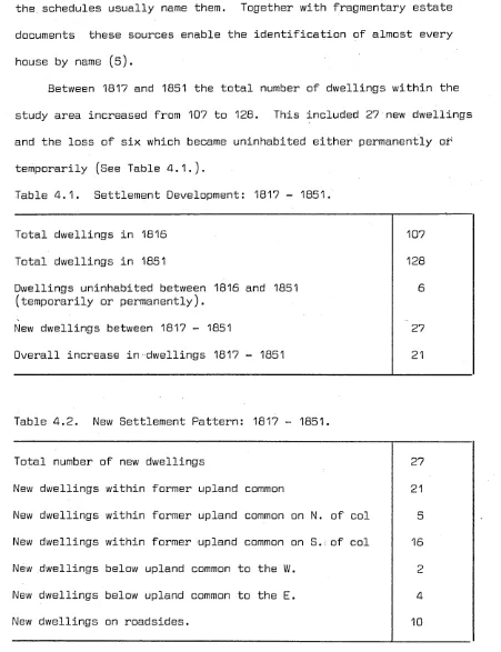
Secondly, 1782 is the earliest date for which records concerning
all farm holdingSwithin the parishes of Rhiw and Llanfaelrhys may collectively be studied. These records exist in the form of the Land Tax Assessment Lists and contain information on each holding giving its name, owner, occupier and the assessments made from 1782 until 1819 (3). By studying these documents alongside estate surveys, rentals and
valuations dated 1774-1790, it is possible to comment upon the division of land ownership, the relative value of holdings and the settlement patterns of that period (4).
Thirdly, it has profcved possible to obtain information from a wide variety of sources in order to form an impression of the social conditions of the time. These include aspects of welfare and charity, law and
I. SETTLEMENT AND LANDOWNERSHIP.
It is possible to plot the settlement pattern in a stable farming district such as the area under review, by using later maps of the whole area such as the 1816 survey for the First Edition Ordnance Survey Map and the 1842/44 Tithe Commutation Maps together with fragmented estate surveys (6). In this way the site of each tenement named in the 1782
Land Tax Assessment Lists can be established. There may have been other tenements in existence which were not noted for assessment or redemption. However, the close correlation between listed tenements and details in
extant pre-1790 estate documents suggest that there were few, if any, such additional settlements (7).
Map 2.1. indicates the distribution of settlements in 1782,
together with the two areas of Crown common as identified in 1802 and 1811 and the roads as surveyed in 1816 (8). It is unlikely that these
features were considerably modified between 1782 and 1816 and they are therefore used in the following comments upon the 1782 settlement pattern. Map 2.1. shows a widely dispersed pattern of settlement similar to that in many parts of culturally and economically remote areas designated as "Highland Britain" at this time. There were no
concentrations around any focal point, although the pattern does indicate links with aspects of the topography, communications network and
historical background of the district.
MAP 2.1: SETTLEMENT PATTERN IN 1782
N.
KEY
• Inhabited dwelling
+ Church/chapel
Roads . . . Common land
Parish boundaries
MAP 2.2: SETTLEMENT IN 1782 IN RELATION TO SOILS
rown Earths Rhlw Sariaa High baaa status frssly drained Madryn Series Low base status freely drained Csdlan Series Low base status f r eel y drained
Qrey Soils Poorly drained
0 K m i 1
1---- l
MAP 2.3: S E T TL EM EN T IN 1 7 8 2 IN RELATION TO ALTITUDE
& M y n y d d
100
Porth Nelgwl
KEY
S e tt l e me nt C hu rc h/ ch ap el Parish boundaries Common land C. G. Creigiau Gwlneu
TOO Altit ude shown ev ery 100 Mynydd
Table 2.1. Settlement and Altitude in 1782.
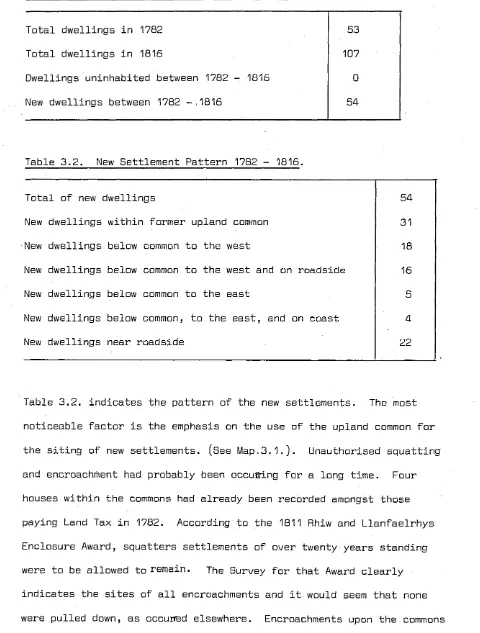
Dwellings over 6001 10
Dwellings between 350' - 6DD' 25
Dwellings below 350' 18
Total number of dwellings 53
The benefits gained by the twenty-eight dwellings on the sunnier western slopes were almost equalled by those received by the twenty-five dwellings on the more sheltered eastern slopes (9). There were no
dwellings along the col or the ridge. The underlying soil was clearly an important consideration with thirty-four dwellings being on fertile, free draining brown earths as compared with nineteen on wet gley
soils (10). (See Map 2.2. Ch.1. p.-^4). Dwellings tended to be built on level sites or, if necessary, endways - on, tucked into the hillside to avoid surface water (.11). They were within reasonable distance from tracks and roads and there was a slight concentration near each of the two coves used for coastal shipping.
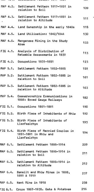
Figure 2.1. shows an analysis of the distribution of the rates in the 1782 Land Tax Assessments and reflects the distribution in value of the holdings. This would vary according to a combination of factors including acreage, type and condition of land, aspect, slope3land use and, indirectly, land ownership. It must be accepted that the Land Tax Assessment Lists may not be complete or accurate. Nevertheless
FIGURE 2.1: ANALYSIS OF DISTRIBUTION OF LAND TAX ASSESSMENT IN 1782
10
N u mb e r
9-of
P r o p e r t i e s 3.
i1 £2
S h i l l i n g s
RHIW LAND TAX ASSESSMENTS IN 1782
1 0 -Number
9-of
P r o p e r t i e s 3
11 13 15 17 19 I 12 14 16' 18
7 9
5 8
Shil lings
LLANFAELRHYS LAND TAX ASSESSMENTS
1213
13
X * ,1 ^ - J
8 9 3I
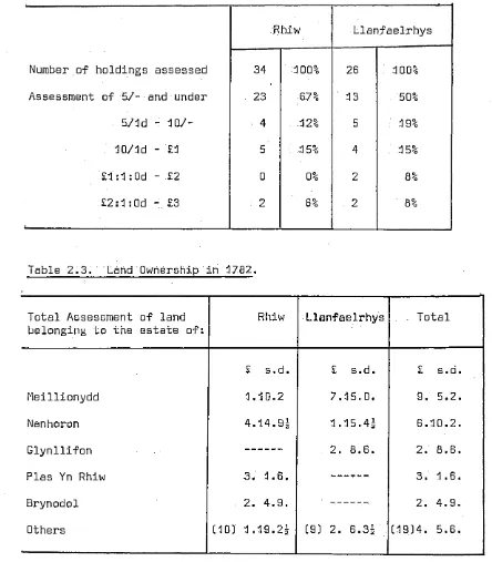
2 i 3 [image:56.614.10.538.62.714.2]Table 2.2. Assessment Rates in 1782.
Rhiw Llanfaelrhys
Number.of holdings assessed 34 . 1 0 0% 26 . 1 0 0%
Assessment of 57- and under . 23 67% . 13 50%
57ld - 107- 4 1 2% 5 : 19%
1071d - £1 5 . 15% 4 . 4 5%
£i:1:0d - £2 0 0% 2 8%
[image:57.615.53.497.48.555.2]£2:1:0d £3 2 6% 2 8%
Table 2.3. Land Ownership in 1782.
Total Assessment of land
belonging to the estate of: Rhiw Llanfaelrhys . Total
£ s.d. £ s.d. £ s.d.
fleillionydd 1.10.2 7.15.0. 9. 5.2.
Nanhoron 4.14.9s 1.15.4s 6.1 0.2.
Glynllifon 2. 8.6. CM CO CD
Plas Yn Rhiw 3. 1.6. 3. 1.6.
Brynodol 2. 4.9. 2. 4.9.
Others C10D' 1.19.2s (9) 2. 6.3s C4 934. 5.6.
The pattern of distribution in Figure 2.1 . and Table 2.2. clearly
indicates a concentration of very low assessments in both parishes, but especially in Rhiw. There is also a more marked gap in values in Rhiw
with only two tenements being assessed at over sixteen shillings,
This probably reflects , the higher number. of large. and medium sized farms within Llanfaelrhys, for which there are historical and topographical reasons.
The control exercised by the five main land owners can be
seen in Table 2.3. where the value of their lands can be compared with that of the nineteen other land owners.
A number of the farms named in 3782 were on the sites of much
earlier settlements. This factor combined with the implications of land ownership for future development, can usefully be clarified by
a brief examination of the history of settlement in the district. Prior to the English conquest .of Wales by 3284 this district was
part of the commote of Cymyd Maen and contained distinct areas under either ecclesiastical or secular lordship (13). ' CSee Map. 2.4.). The monastery on the island of Bardsey, some six miles to the west, enjoyed extensive properties and privileges on the mainland within the study area west and north of Mynydd Rhiw. Amongst these was the coastal township of Ultradaron which included the hamlets of Ysgo and Llawenan. These were probably grain producing areas, and a grange
was recorded at the neighbouring hamlet of Cadlan. Further inland was another grange, Cwmdylif, now in the lands of Meillionydd
farm (14).
The secular lordship was under the control of Llewelyn and contained both the free communities in the townships of Rhiw and Bodrhydd, and also the servile bond hamlet of Penarfynydd. In 4352 this hamlet was still required to render dues and a certain measure of corn to the Lord's manor at Neigwl, approximately one mile east
MAP 2.4: SOME PRE 1782 SETTLEMENTS
Bryncroes Botwnnog
Cwmdy lif
> Meillionydd MYNYDD RHIW Bodrhydd
r T y ddyn crcesiog. Rhiw Bodwrdda
Llawenan KEY
Parish boundaries Cadlan Penarfynydd
Modern roads f A be r da ro n Penrhyn
+ Church
O
House named in 16th century A Fr ee township D Mo nastic township GD Monastic grangeServile township
Kms
Clas church
In 1284 Edward I succeeded by "right of conquest" to the territories of Llewelyn and the areas of common, manors and bond townships became Crown Land (16). This greatly influenced the
pattern of later land ownership. When purchase of these lands became
possible in Elizabethan times, the consolidated bond townships were usually purchased as a unit, and they have tended to remain as distinct units up to the present day. Penarfynydd is as example of this (17). Both rocky upland and marshy lowland commons remained Crown land until the Enclosure Movement in the early nineteenth century, although
encroachments have no doubt been made over the centuries (18). After the dissolution of the monastery of Bardsey in 1536 the development of local estates such as Bodwrdda and later Meillionydd occurred. Tudor surveys indicate the early development of monastic hamlets such as Ysgo and Llawenan into the consolidated farms now on these sites (19). Much of the free township of Bodrhydd was contained
in the later ecclessiastical parish of Llanfaelrhys although a small farm of that name survives just beyond the parish boundary. (2D.). In the free townships the policy of partible inheritance led to the ownership of small scattered parcels of land by the descendants of a common ancestor (21). This uneconomic structure was maintained by strong community relationships in the communal working of the land as well as through family ties (2 2).
By the eighteenth century the failure to produce male heirs and a series of early deaths resulted in several local family estates
being absorbed, by marriage, into larger more distant estates, with some of the implications of absentee land lords.
MAP 2.5: LAND OWNERSHIP CIRCA 1782
Compi l ed from v ar io us E s t a t e S u r ve y s 1776 - 84
'Sychnaut
Meillionydd
Plas yn Rhiw Bod wyd dog
KEY
Crown land 1775
Nanhoron Pena rf yny dd Me illionydd Y sgo
Cef namwl ch P e n a r f y ny d d
T y ' n Ion
Ll anf al r Brynodol Plas yn Rhiw
Unknown Kme P a r i s h boundar y
importance in the area (24). The former holdings of the Cefn Amwlch estate within the study area appear.. to have been sold to a variety of small holders around 1774 at a time when the family may have been in financial difficulty (25). The Brynodol estate, formerly a cadet branch of Cefn Amwlch, which owned three holdings in Rhiw, remained
stable during this period. The Meillionydd estate passed, on the
marriage of the heiress, to the Vaughan family of Nannau and Hengwrt (26). The smaller compact estate of Plas Yn Rhiw passed, with the marriage
of that heiress*to William Williams but this family continued to live in Rhiw (27).
The important developments in land ownership can be seen in Map 2.5. The large compact farms frequently indicate those former monastic and servile hamlets, whilst the irregular shape of dispersed plots indicate some of the small holdings acquired later by those purchasing land to consolidate their estates.
By 1782 the lands of the two locally based estates, Plas Yn Rhiw and Bodwyddog, appear to have developed contrasting settlement patterns. The Plas Yn Rhiw estate contained nine farms in addition to the manor house, with these forming a "girdle settlement" around the circumfer
ence of the estate which, for the greater part, bordered on upland common land (28). Bodwyddog (See Map 2.5.), however, remained as a
single farming unit. This may have been due to its position at a lower altitude on less steep but also less fertile slopes, or to the fact that it had become part of the extensive Nanhoron estate.