Spatial Temporal Analysis of LU/LC Classification in Nirmal Mandal, Adilabad, Telangana State, India, by Using Remote Sensing and GIS
Full text
Figure


Related documents
LAND USE AND LAND COVER CHANGE DETECTION STUDY AT INDIAN SUNDARBAN DELTA USING REMOTE SENSING AND GIS..
ecosystem monitoring, Google Earth Engine, image classification, IUCN Red List of Ecosystems, land cover mapping, Landsat Archive, remote sensing, satellite mapping... distribution
Use of satellite remote sensing for soil survey and mapping have been also received appreciation in India, and based on the potential of remote sensing techniques it can map
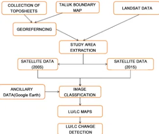
In the present study remote sensing and Geographical information system techniques are used for detecting land use and land cover changes for the year 1995, 2005 and
The objective of this paper was to classify and map land use - land cover (LULC) of the study area using Remote Sensing and GIS techniques and also to carry out accuracy assessment
The spatial, temporal and spectral characteristics of the remote sensing data are effectively used in land use and land cover change mapping, hence helping in deci- sion making
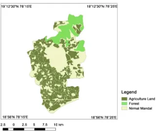
Land use / land cover, drainage density, geology, slope, hydro geomorphology and water table depth using remote sensing and GIS technique.. The ground water
Vegetation index (NDVI) Land cover (LC) Rainfall Irrigation status Ground water capacity (GWC) Drainage condition Field checking Farmer interview Remote sensing Geographical
