Using a fuzzy control system to optimise the parametric
method for selecting the appropriate irrigation system
Yaser Hoseini*, Manochehr Shiri Janaghard
Department of Irrigation and Drainage, Faculty of Agriculture, Moghan College of Agriculture and Natural Resource, University of Mohaghegh Ardabili, Ardabil, Iran
*Corresponding author: [email protected]
Citation: Hoseini Y., Shiri Janaghard M. (2019): Using a fuzzy control system to optimise the parametric method for selecting the appropriate irrigation system. Res. Agr. Eng., 65: 70–75.
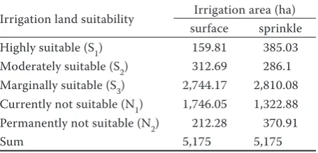
Abstract: In this study, a fuzzy logic system was used to optimise a parametric evaluation system in surface and sprinkler irrigation systems. This study was performed on a surface area of 5,175 ha in the Fath-Ali region located in the Ardabil province of Iran. It was indicated that for the sprinkler and surface irrigation system, an area of about 385.06 ha (7.4%) and 159.81 ha (3%) of land is “highly suitable” and an area of about 286.1 ha (5.5%) and 312.69 ha (6%) is “moderately suitable”, respectively. About 2,810.08 ha (54.3%) and 2,744.17 ha (53.02%) were respectively “marginally suitable” for the sprinkler and surface irrigation systems. The “currently not suitable” suitability included about 1,322.88 ha (25.5%) and 1,746.05 ha (33.7%) and the “permanently not suitable”suitability included about 370.91 ha (7.1%) and 212.28 ha (4.1%) in the zone under study. According to the results, there is a major difference between the “highly suitable” land obtained through the two methods and the area of the “highly suitable” land us-ing the sprinkler irrigation method is about two times the area of the “highly suitable” obtained through the surface irrigation method.
Keywords: surface irrigation; evaluation of lands; sprinkler irrigation; optimisation
Selecting a proper irrigation method in irrigated agriculture in order to achieve a high efficiency and maximum water use and soil and water conserva-tion are as important as pest control and adding fer-tilizers in a crop’s production. The agricultural land suitability for the irrigation assessment is defined as the process of the land performance assessment when the land is used for alternative kinds of irriga-tion (Ahmed 2016; Diallo et al. 2016). The prin-ciple purpose of the agricultural land suitability for the irrigation evaluation is to predict the potential land and its limitation for kinds of irrigation meth-ods (Abdel Rahman et al. 2016). In Iran, evaluating the land suitability for selecting the irrigation meth-ods is vital for agricultural development. A GIS-based land suitability analysis is essential to assess the potential and constraints of a given land parcel for irrigation purposes. Sys et al. (1991) proposed a parametric evaluation system to select the irrigation
Valdivia-Cea et al. 2017). But all of these studies ignore the continuous changes of the soil properties and, thus, it causes their evaluation results to be not accurate enough. This problem is solved by consid-ering a fuzzy system and its membership functions. Fuzzy systems are, today, one of the most efficient methods in the field of forecasting and modelling (Akbarzadeh et al. 2009). Using fuzzy logic capa-bilities which stem from the ability of a continuous membership function of input variables and by a combination of parameters affecting the irrigation methods evaluation in the parametric system. Thus, this study aimed to utilise the functionalities of the fuzzy logic method to evaluate the land suitability of the studied area based on the parametric system for sprinkler and surface irrigation. Moreover, the purpose of this study was to optimise the parametric lands suitability evaluation system uses of the fuzzy logic system.
MATERIAL AND METHODS
The region studied covers an area of 5,175 ha of part of the Fath-Ali plain land at a distance of ap-proximately 35 km southwest from the city of Pars Abad and 230 km northwest from the city of Ar-dabil. The geographical coordinates of the lands are 47°35'56''E to 47°43'21''E and 39°25'12''N to 39°28'28''N. The soil moisture regime is weak aridic, a subcategory of aridic, and its thermal regime is thermic. Fig. 1 shows the location of pressurised ir-rigation network of Moghan Fath-Ali. In this paper, data from 20 stations was used which was derived from reports on detailed soil studies and the classifi-cation of the Fath-Ali Plain lands in Pars Abad. The project employer was the Agricultural Organization of Ardabil province and the studies were conducted
by the country’s Soil and Water Engineering Servic-es Company. The summary of physical and chemical test results are represented in Table 1. Fig. 2 shows maps of the land units in the studied area.
Fuzzification of the parameters affecting the land evaluation through the parametric meth-od. Fuzzy systems are composed of three parts: (i) fuzzy sets, (ii) membership functions, (iii) fuzzy rules (Fig. 3).
In the parametric technique, soil properties are graded and used to calculate the irrigation suitabil-ity index (Ci) by the following function (Eq. 1):
100 100 100 100 100
i B C D E F
C A (1)
where: A, B, C, D, E, F – are the gradation values of the soil texture, depth, lime, electrical conductivity, drain-age, slope, respectively
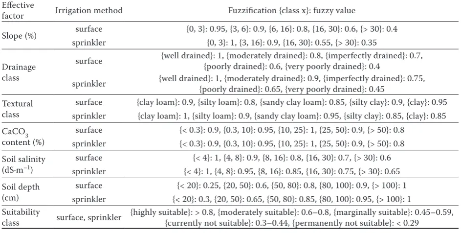
[image:2.595.304.534.97.221.2]Some specified signs are used in the parametric evaluation of the land suitability. These signs in-clude S1 (highly suitable), S2 (moderately suitable), S3 (marginally suitable), N1 (currently not suitable) and N2 (permanently not suitable). Depending on the type of irrigation, the values given to each tor based on the membership function of each fac-tor are shown in Table 2. Eq. 2 and the spatial data modeller (SDM) in the GIS extension were used to Fig. 1. Schematic of the study area
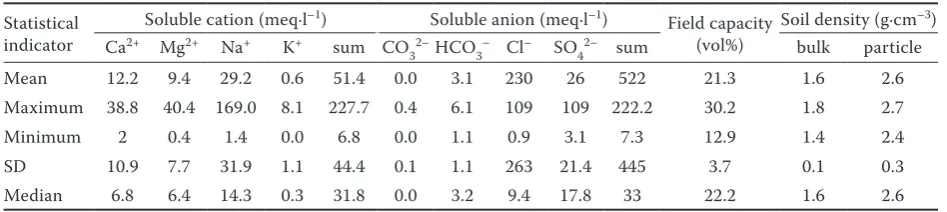
Table 1. The physical and chemical properties of the soil samples
Statistical indicator
Soluble cation (meq·l–1) Soluble anion (meq·l–1)
Field capacity (vol%)
Soil density (g·cm–3)
Ca2+ Mg2+ Na+ K+ sum CO
32–HCO3– Cl– SO42– sum bulk particle
Mean 12.2 9.4 29.2 0.6 51.4 0.0 3.1 230 26 522 21.3 1.6 2.6
Maximum 38.8 40.4 169.0 8.1 227.7 0.4 6.1 109 109 222.2 30.2 1.8 2.7
Minimum 2 0.4 1.4 0.0 6.8 0.0 1.1 0.9 3.1 7.3 12.9 1.4 2.4
SD 10.9 7.7 31.9 1.1 44.4 0.1 1.1 263 21.4 445 3.7 0.1 0.3
Median 6.8 6.4 14.3 0.3 31.8 0.0 3.2 9.4 17.8 33 22.2 1.6 2.6
SD – standard deviation
[image:2.595.62.536.636.742.2]integrate the factors affecting the land evaluation. Using the factor provided in Eq. 2 and by taking γ = 0 into consideration, the effective factors were mul-tiplied together and the final map was extracted:
λ 1λ
1 1
μ n μi x n μi x
i i
x
(2)where: x – effective parameter; µi – is the fuzzy member-ship function for factor i; λ – is the proper power to obtain the best results, which is equal to 0 based on the paramet-ric method in this study
After the map of each factor is provided based on the values specified in the Table 2, the land evalua-tion index of the different points was extracted by overlaying all the obtained maps. Fig. 4 represents the diagram of the method steps.
RESULTS AND DISCUSSION
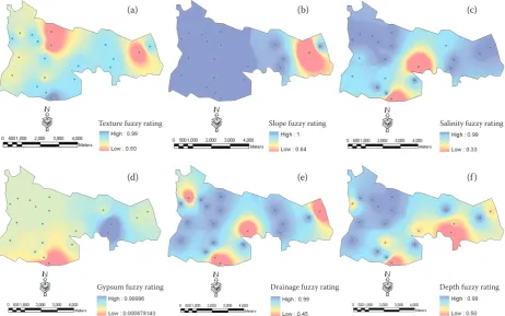
[image:3.595.75.279.92.446.2]The membership function map of the param-eters influencing the assessment of the irrigation systems is represented in Fig. 5. According to the fuzzy membership function, the suitable places for surface and sprinkler irrigation systems are classi-fied between 0 (not suitable lands) and 1 (very suit-able lands) which are illustrated in Figs 6a, b for the surface and sprinkler methods.
Fig. 2. Map of the land units
Sampling points Land units
Fig. 3. Membership functions of the non-fuzzy (a) and fuzzy (b) sets; X – effective parameter
Variable X
M
em
be
rs
hi
p
fu
nc
tio
n
M
emb
ers
hip f
unc
tion
(a)
[image:3.595.62.534.523.761.2](b)
Table 2. Fuzzification of the selection parameters of the irrigation method and the factor’s membership functions based on a parametric system
Effective
factor Irrigation method Fuzzification {class x}: fuzzy value
Slope (%) surface {0, 3}: 0.95, {3, 6}: 0.9, {6, 16}: 0.8, {16, 30}: 0.6, {> 30}: 0.4
sprinkler {0, 3}: 1, {3, 16}: 0.9, {16, 30}: 0.55, {> 30}: 0.35
Drainage class
surface {well drained}: 1, {moderately drained}: 0.8, {imperfectly drained}: 0.7, {poorly drained}: 0.6, {very poorly drained}: 0.4
sprinkler {well drained}: 1, {moderately drained}: 0.9, {imperfectly drained}: 0.75, {poorly drained}: 0.65, {very poorly drained}: 0.45
Textural class
surface {clay loam}: 0.9, {silty loam}: 0.8, {sandy clay loam}: 0.85, {silty clay}: 0.9, {clay}: 0.95 sprinkler {clay loam}: 1, {silty loam}: 0.9, {sandy clay loam}: 0.95, {silty clay}: 0.85, {clay}: 0.85 CaCO3
content (%)
surface {< 0.3}: 0.9, {0.3, 10}: 0.95, {10, 25}: 1, {25, 50}: 0.9, {> 50}: 0.8 sprinkler {< 0.3}: 0.9, {0.3, 10}: 0.95, {10, 25}: 1, {25, 50}: 0.9, {> 50}: 0.8 Soil salinity
(dS·m–1) sprinklersurface {< 4}: 1, {4, 8}: 0.95, {8, 16}: 0.85, {16, 30}: 0.75, {> 30}: 0.65{< 4}: 1, {4, 8}: 0.9, {8, 16}: 0.8, {16, 30}: 0.7, {> 30}: 0.6
Soil depth (cm)
surface {< 20}: 0.25, {20, 50}: 0.6, {50, 80}: 0.8, {80, 100}: 0.9, {> 100}: 1 sprinkler {< 20}: 0.3, {20, 50}: 0.65, {50, 80}: 0.85, {80, 100}: 0.95, {> 100}: 1 Suitability
As specified in Figs 6a, b, in the evaluation of the land suitability for the sprinkler irrigation based Fig. 4. Diagram of the parametric evaluation method using GIS
EC – electrical conductivity; A, B, C, D, E, F – gradation values of the soil texture, depth, lime, electrical conductivity, drainage, slope, respectively; Ci – irrigation suitability index
Databases
Factor A Factor B Factor C Factor D Factor E Factor F
Soil
texture dephtSoil CaCO3 EC Drainage Slope
A B C D E
F
Overlay
Attribute data
Resultant layers
Ci = A × B/100 × C/100 × D/100 × E/100 × F/100
Irrigation suitability map
Fig. 5. Membership function map of the parameters influencing the irrigation system evaluation: soil texture (a), slope of the land (b), soil salinity (c), calcium carbonate (d), drainage condition (e), soil depth (f)
on the fuzzy system, the western areas of the plain have the proper potential for implementation of the sprinkler irrigation system (Table 3), so they have S1 suitability which is composed of an area of about 385.06 ha (7.4%). Lands with S2 suitability consist of an area of 286.1 ha (5.5%). Moreover, the majority of the lands have S3 suitability in an area of 2,810.08 ha (54.3%). Also, parts of the central and eastern areas of the plain have N1 suitability consisting of an area of 1,322.88 ha (25.5%). And the central and eastern lands of the plain have N2 suitability with an area about 370.91 ha (7.2%). Besides, based on the fuzzy evaluation for the surface method, the eastern lands of the plain are less suitable for this type of irriga-tion. Accordingly, lands with S1 suitability com-prise an area of 159.81 ha (3%) and lands with S2 suitability consist of an area about 312.69 ha (6%). In addition, the northern and north-eastern lands of the plain have S3 suitability with an area about 2,744.17 ha (53%). Some parts of the south-western and eastern lands have N1 suitability consisting of an area of 1,746.05 ha (33.7%). In parts of the central and eastern lands of the plain, N2 suitability can be seen which encompasses an area of 212.28 ha (4.1%). According to Figs 6a, b, the best land units for the
(a) (b) (c)
(d) (e) (f)
Texture fuzzy rating Slope fuzzy rating Salinity fuzzy rating
[image:4.595.67.530.439.728.2]surface and sprinkler irrigation systems based on the fuzzy system include units 5, 6and 11, in which a majority of them are located on the west side of the Fath-Ali plain. Also, parts of units 16 and 17 are con-sidered as areas suitable for the sprinkler irrigation method. Since soil salinity, slope and drainage capa-bility cause fewer restrictions in sprinkler irrigation systems, as illustrated in Figs 6a, b, the proportion of lands suitable for the sprinkler irrigation method based on the fuzzy system is more than 2 times great-er than for the surface method. The results showed that there is a major difference between the two methods in terms of highly suitable lands, in which the area of lands highly suited for the sprinkler irri-gation method is almost 2 times the size of the lands suited for the surface method, which reflects the sig-nificant difference between the land levels suited for the irrigation using the two methods. By comparing the figures related to the scores of unit 16 which is about 500 ha, it turned out that the values consid-ered based on the parametric system have been high in all the effective parameters except for the scores related to the soil salinity and that is why this unit was considered as the highly suitable unit in the final conclusion. While, if we regard the amount of this
[image:5.595.65.403.92.260.2]unit obtained from the fuzzy evaluation in Figs 6a, b, it becomes obvious that given the influence of the neighbouring units, a part of this unit acquires an av-erage score, thus, a part of this unit area consists of marginally suitable lands. This applies to units 5, 6, 11, 14 and 7, in addition, units 7 and 14 which have especially earned average scores in the fuzzy evalua-tion in relaevalua-tion to the parameters of soil salinity and calcium carbonate. Also, the area of moderately suit-able lands with the surface irrigation method is al-most equal to the area of moderately suitable lands with the sprinkler method. The moderately suitable lands in the fuzzy approach are located in the vicinity of the highly suitable lands. These lands are mainly located in the vicinity of units 6, 11 and 16 and as it is clear, it seems that the fuzzy evaluation used for de-termining the moderately suitable lands is closer to reality. Because of this point, it seems reasonable that the moderately suitable lands are located adjacent to the highly suitable lands. Considering the gradual changes of the soil parameters in the fuzzy evalua-tion makes this method more accurate than the para-metric technique. A number of studies conducted in this relation indicated that an evaluation using para-metric methods could be as accurate as those em-ploying fuzzy techniques (Sanchez Moreno 2007; Keshavarzi, Sarmadian 2009; Bagherzadeh, Mansouri Daneshvar 2011). These results contra-dict those findings in the present research. Moreover, Bagherzadeh and Gholizadeh (2016) used para-metric and fuzzy methods to evaluate the lands. They showed that, although the fuzzy method was more accurate than the parametric method, the paramet-ric method was still able to determine the land qual-ity with suitable accuracy. This indicates that if there is a small number of limiting and influential factors, under the conditions of classifying the parameters Table 3. The area of land suitability in the fuzzy logic
evaluation method
Irrigation land suitability Irrigation area (ha)
surface sprinkle
Highly suitable (S1) 159.81 385.03
Moderately suitable (S2) 312.69 286.1
Marginally suitable (S3) 2,744.17 2,810.08
Currently not suitable (N1) 1,746.05 1,322.88
Permanently not suitable (N2) 212.28 370.91
[image:5.595.64.292.648.758.2]Sum 5,175 5,175
Fig. 6. Land suitability map for the surface (a), sprinkler (b) irrigation
(a) (b)
Surface irrigation suitability
Border Sampling stations
Surface irrigation suitability
by the fuzzy membership functions, the influence of these factors on the results will decrease and the results of the parametric method will become close to those of the fuzzy logic technique. In the present research, the results of the two methods were very different because there were various limiting factors in the region such as soil texture, calcium carbon-ate content, and soil depth. Apparently, it is better to use fuzzy techniques to estimate the capability of the lands for various irrigation practices because most agricultural soils in Iran face different limitations.
CONCLUSION
Determining the land suitability grade for various irrigation methods can improve the crop per drop in these areas. Moreover, using a fuzzy logic system to evaluate the land suitability for the irrigation can increase the accuracy of the parametric evaluation system. According to the results, there was a major difference between the highly suitable lands obtained through the fuzzy and conventional parametric methods. This showed that the fuzzy approach dif-fered from the conventional land suitability evalua-tion methods such as the parametric method in its use of the calculated eigenvalues and the organisation of the criteria in the membership functions to fit the suitability problems into the framework of the deci-sion-making. By considering the gradual changes in the soil parameters, it was shown that the fuzzy eval-uation led to more accurate results compared to the parametric method. This paper also confirmed that the fuzzy approach, as a perfect method, could be useful to evaluate areas suitable for various irrigation methods, especially in areas with more restrictions.
References
Abdel Rahman M.A.E., Natarajan A., Hegde R. (2016): As-sessment of land suitability and capability by integrating remote sensing and GIS for agriculture in Chamarajanagar district, Karnataka, India. The Egyptian Journal of Remote Sensing and Space Sciences, 19: 125–141.
Ahmed M.A.E. (2016): Land evaluation of Gharb El-Mawhob area, El Dakhla oasis, New Valley, Egypt. [MSc Thesis.] Assiut, Assiut University.
Akbarzadeh A., Mehrjardi R.T., Rouhipour H., Gorji M., Rahimi H.G. (2009): Estimating of soil erosion covered
with rolled erosion control systems using rainfall simulator (neuro-fuzzy and artificial neural network approaches). Journal of Applied Science Research, 5: 505–514.
Albaji M., Land A., Mravvej K., Broomand Nasab S. (2006): Land evaluation for irrigated agriculture for surface and sprinkle irrigation methods for the base production of Shavoor plain of Khuzestan. [MSc Thesis.] Ahvaz, Shahid Chamran University of Ahvaz. (in Persian)
Bagherzadeh A., Gholizadeh A. (2016): Modeling land suit-ability evaluation for wheat production by parametric and TOPSIS approaches using GIS, northeast of Iran. Modeling Earth Systems and Environment, 2: 126. doi: 10.1007/ s40808-016-0177-8
Bagherzadeh A., Mansouri Daneshvar M.R. (2011): Physical land suitability evaluation for specific cereal crops using GIS at Mashhad plain, northeast of Iran. Frontiers of Ag-riculture in China, 5: 504–513.
Diallo M.D., Wood S.A., Diallo A., Mahatma-Saleh M., Ndi-aye O., Tine A.K., Ngamb T., Guisse M., Seck S., Diop A., Guisse A. (2016): Soil suitability for the production of rice, groundnut, and cassava in the peri-urban Niayes zone, Senegal. Soil and Tillage Research, 155: 412–420.
Kebede T., Ademe Y. (2016): Evaluating land suitability for irrigation purpose in Abaya district, Borena zone, Ethiopia. African Journal of Agricultural Research, 11: 4754–4761. Keshavarzi A., Sarmadian F. (2009): Investigation of fuzzy
set theory’s efficiency in land suitability assessment for irrigated wheat in Qazvin province using analytic hierar-chy process (AHP) and multivariate regression methods. In: Minasny B.: Proceedings of the “Pedometrics 2009” Conference, Beijing, Aug 26–28, 2009: 38–46.
Naseri A.A., Rezania A.R., Albaji M. (2009): Investigation of soil quality for different irrigation systems in Lali plain, Iran. Journal of Food, Agriculture & Environment, 7: 955–960. Sanchez Moreno J.F. (2007): Applicability of knowledge-based
and fuzzy theory-oriented approaches to land suitability for upland rice and rubber, as compared to the farmers’ per-ception. A case study of Lao PDR. [MSc Thesis.] Enschede, International Institute for Geo-information Science and Earth Observation.
Sys C., Van Ranst E., Debaveye J. (1991): Land Evaluation. Part I: Principles in Land Evaluation and Crop Production Calculations. Brussels, General Administration for Devel-opment Cooperation.
Valdivia-Cea W., Holzapfel E., Rivera D., Paredes G. (2017): Assessment of methods to determine soil characteristics for management and design of irrigation systems. Journal of Soil Science and Plant Nutrition, 17: 735–750.