Generating and Evaluating Landmark-based Navigation Instructions in
Virtual Environments
Amanda Cercas Curry School of Mathematical and
Computer Sciences Heriot-Watt University
Edinburgh [email protected]
Dimitra Gkatzia School of Mathematical and
Computer Sciences Heriot-Watt University
Edinburgh
Verena Rieser School of Mathematical and
Computer Sciences Heriot-Watt University
Edinburgh
Abstract
Referring to landmarks has been identi-fied to lead to improved navigation in-structions. However, a previous corpus study suggests that human “wizards” also choose to refer to street names and gener-ate user-centric instructions. In this paper, we conduct a task-based evaluation of two systems reflecting the wizards’ behaviours and compare them against an improved version of previous landmark-based sys-tems, which resorts to user-centric de-scriptions if the landmark is estimated to be invisible. We use the GRUVE vir-tual interactive environment for evalua-tion. We find that the improved system, which takes visibility into account, outper-forms the corpus-based wizard strategies, however not significantly. We also show a significant effect of prior user knowledge, which suggests the usefulness of a user modelling approach.
1 Introduction
The task of generating successful navigation in-structions has recently attracted increased atten-tion from the dialogue and Natural Language Generation (NLG) communities, e.g. (Byron et al., 2007; Dethlefs and Cuay´ahuitl, 2011; Ja-narthanam et al., 2012; Dr¨ager and Koller, 2012) etc. Previous research suggests that landmark-based route instructions (e.g. “Walk towards the Castle”) are in general preferable because they are easy to understand, e.g. (Millonig and Schechtner, 2007; Chan et al., 2012; Elias and Brenner, 2004; Hansen et al., 2006; Dr¨ager and Koller, 2012). However, landmarks might not always be visible to the user. A recent corpus study by Cercas and Rieser (2014) on the MapTask and two
Wizard-of-Oz corpora, Spacebook1 and Spacebook2,1
empir-ically investigated the type of reference objects hu-man instruction givers tend to choose under differ-ent viewpoints. It was found that human “wizards” do not always generate instructions based on land-marks, but also choose to refer to street names or generate user-centric instructions, such as “ Con-tinue straight”.
This paper compares three alternative genera-tion strategies for choosing possible reference ob-jects: one system reflecting an improved version of a landmark-based policy, which will resort to a user-centric description if the landmark is not vis-ible; and two systems reflecting the wizards’ be-haviours in Spacebook1 and Spacebook2. We hy-pothesise the first system will outperform the other two in terms of human-likeness and naturalness, as defined in Section 3. We use the GRUVE (Giving Route Instructions in Uncertain Virtual Environ-ments) system (Janarthanam et al., 2012) to evalu-ate these alternatives.
2 Methodology
We designed two corpus-based strategies (Sys-temB,C) and one rule-based system based on a heuristic landmark selection algorithm (A). Also see examples in Table 1. Strategies for systems B and C aim to emulate the wizards’ strategies de-pendent on different viewpoints: System B uses data from Spacebook1, where the wizard follows the user around, and thus, shares the viewpoint of the user. System C uses data from Spacebook2, where the wizard follows the user remotely on GoogleMaps via GPS tracking, and thus, street names are visible to the wizard, but only the ap-proximate location is known.
Systems Output
System A “Keep going straight to-wards Farmfoods Ltd.” (landmark)
System B “Continue straight” (
user-centric)
[image:2.595.88.507.63.185.2]System C “Keep walking along Nicholson Street”(street name)
Table 1: Example of user view on GoogleStreetMaps (left) and system outputs (right).
previous work, in that it mainly produces landmark-based instructions, but resorts to user-centric instructions when no landmarks are available (also see our landmark selection algorithm as described below). We also call this thevisibilitystrategy.
• System B: Spacebook1-based strategy pro-duces instructions using street names, land-marks and user-centric references in the same proportions as the wizards in Spacebook1. We also call this theshared viewpointstrategy. • System C: Spacebook2-based strategy
pro-duces landmark-based and street name-based instructions as in Spacebook2. A landmark or a street name is selected based on a thresh-old on the landmark’s salience (determined through trial and error). We also call this the
birds-eyestrategy.
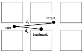
All three strategies select landmarks based on landmark salience, following G¨otze and Boye (2013), using a heuristic based on (also see Fig-ure 1): the distance between the landmark and the user, the distance between the user and the target, the angle formed by these two lines, the type of landmark and whether the landmark has a name. We adjusted this heuristic to match our system.
Figure 1: Spatial features used by landmark heuristic.
Note that GRUVE only provides information on
static landmarks, e.g. shops, restaurants, banks, etc., available from GoogleMaps and Open Street Map. It does not identify moving objects, such as cars, as potential landmarks. In current work (Gkatzia et al., 2015), we investigate how to gen-erate landmarks based on noisy output from object recognition systems.
3 Evaluation
3.1 Experimental Setup
We used the GRUVE virtual environment for eval-uation. GRUVE uses Google StreetView to simu-late instruction giving and following in an inter-active, virtual environment, also see Table 1. We recruited 16 subjects, with an even split amongst males and females and age ranges between 20 and 56. Six users were not native English speakers.
Before the experiment, users were asked about their previous experience. After the experiment we asked them to rate all systems on a 4-point Lik-ert scale regarding human-likeness and natural-ness (where 1 was “Agree” and 4 was “Disagree”).
Human-likeness is defined as an instruction that could have been produced by a human. Natural-nessis defined as being easily understood by a hu-man. The order of systems was randomised.
4 Results
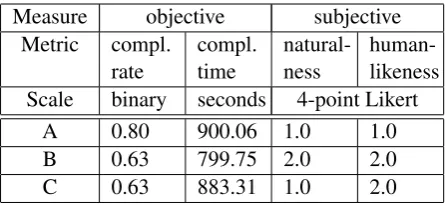
In total we gathered 1071 navigation instructions. For evaluation, we compared a number of objec-tive and subjecobjec-tive measures. The results are sum-marised below (also see Table 2) :
[image:2.595.114.250.613.699.2]not statistically significant (χ2 test, p=.574).2
However, a planned comparison for task com-pletion time showed that users take longer when using System A compared to the two other systems, but again the difference be-tween the systems was not found to be sta-tistically significant (Mann-Whitney U-Test3,
p=.739 for System A vs. B, p=.283 for A vs. C, and p=.159 for C vs. B).
• Human-likeness and Naturalness: Further-more, users tend to rate System A higher for human-likeness (χ2, p=.185) and for
nat-uralness (χ2, p=.093) than system B and C,
but again the difference was not statistically significant. We also observed the following mixed effects: Users tend to report the system to be more natural and human-like if they had managed to complete the task (χ2, p=.002 and
p=.000, respectively). This could be a reflec-tion of user frustrareflec-tion, where users report the system to be less human-like if they are dissat-isfied with the instructions provided.
• Familiarity Effects:We also observed the fol-lowing effects of prior user knowledge: Ten users reported they were familiar with the lo-cation before the experiment. These users were significantly more likely to report that the instructions were accurate and of the correct length (χ2, p=.037).
In addition, users familiar with Google StreetView found the instructions to be sig-nificantly easier to follow (χ2, p=.003), more
accurate and more natural and human (χ2,
p=.021) compared to those with little or no ex-perience. Only two users reported having no experience with Google StreetView, eight ported having a little experience and six re-ported being very familiar with it. These fa-miliarity effects of prior knowledge suggest a user-modelling approach.
4.1 Discussion
The data shows an indication that System A is able to better support task completion, while be-ing perceived more natural than Systems B and C. However, this trend is not significant. Table 3 shows an analysis of how often each system chose
2Although the percentage difference seems large it is equivalent to only two subjects.
3We used the non-paramentric version of a t-test since the data was not normally distributed.
Measure objective subjective Metric compl.
rate
compl. time
natural-ness
human-likeness Scale binary seconds 4-point Likert
A 0.80 900.06 1.0 1.0
B 0.63 799.75 2.0 2.0
[image:3.595.307.530.62.165.2]C 0.63 883.31 1.0 2.0
Table 2: Average results for objective (mean) and subjective (mode) measures.
a reference object in our experiments. System A produces significantly more landmark-based de-scriptions than B and C (Mann-Whitney U-test for nonparametric data, p=.003 and p=.041 respec-tively). These results seem to confirm claims by prior work that landmark-based route instructions are in general preferable. In future work, we will compare our improved version, which also uses user-centric descriptions, with a vanilla landmark-based strategy in order to determine the added value of taking visibility into account.
System landmark user-centric street name
System A 66.22 33.78 0
System B 61.54 23.50 14.96
System C 56.05 0 43.95
Table 3: Frequencies of reference objects chosen by each system.
4.2 User Comments and Qualitative Data
Users were asked to provide some additional com-ments at the end of the questionnaire. Overall, the subjects reported liking the use of landmarks like shops and restaurants. Users not familiar with the location found this less useful, particularly when the system referred to buildings that were not la-belled on StreetView. For example, the location natives can easily identify the Surgeon’s Hall in Edinburgh, but for those who are unfamiliar with the neighbourhood, the building is not so eas-ily identifiable. Users also reported liking user-centric instructions as they are simple and con-cise, such as “Turn left”. Some users reported they would like to know how far away they are from their destination. A few users also commented that the instructions could be repetitive along long routes.
were not visible, whether because they were too far away or they were hidden by another building. There was no difference in the number of users reporting this for each system. This suggests the landmark-selection heuristic will require further adjustments, e.g adjusting the weights or limiting the search area. Users that were familiar with the location reported that although some of the land-marks presented were not visible, they were still helpful as the users knew where these landmarks were and could make their way to them. The use of landmarks that are not necessarily visible but are known to the instruction follower is com-mon acom-mongst human direction givers, using these landmarks as a starting point for further directions (Golledge, 1999). Again, these findings suggest the usefulness of a user modelling approach to landmark selection.
5 Conclusions and Future Work
This paper presented a task-driven evaluation of context-adaptive navigation instructions based on Wizard-of-Oz data. We found that a heuristic-based system, which uses landmarks and user-centric instructions dependent on estimated visi-bility, outperforms two corpus-based systems in terms of naturalness and task completion, how-ever, these results were not significant. In future work, we hope to recruit more subjects in order to show statistical significance of this trend. Our results also show that there are significant famil-iarity effects based on prior user knowledge. This suggests a user modelling approach will be useful when it comes generating navigation instructions, e.g. following previous work on user modelling for NLG in interactive systems (Janarthanam and Lemon, 2014; Dethlefs et al., 2014). Finally, we hope to repeat this experiment under real-world conditions, rather than in a virtual setup in order to eliminate artefacts, such as the influence of tech-nical problems.
Acknowledgements
This research received funding from the EPSRC GUI project - “Generation for Uncertain Infor-mation” (EP/L026775/1) and EPSRC DILiGENt - “Domain-Independent Language Generation” (EP/M005429/1).
We would like to thank Oliver Lemon for his help-ful comments.
References
Donna Byron, Alexander Koller, Jon Oberlander, Laura Stoia, and Kristina Striegnitz. 2007. Generating In-structions in Virtual Environments ( GIVE ): A Chal-lenge and an Evaluation Testbed for NLG. In Work-shop on Shared Tasks and Comparative Evaluation in Natural Language Generation.
Edgar Chan, Oliver Baumann, Mark a Bellgrove, and Jason B Mattingley. 2012. From objects to land-marks: the function of visual location information in spatial navigation. Frontiers in psychology, 3:304, January.
Nina Dethlefs and Heriberto Cuay´ahuitl. 2011. Combining hierarchical reinforcement learning and bayesian networks for natural language generation in situated dialogue. InProceedings of the 13th Eu-ropean Workshop on Natural Language Generation (ENLG).
Nina Dethlefs, Heriberto Cuay´ahuitl, Helen Hastie, Verena Rieser, and Oliver Lemon. 2014. Cluster-based prediction of user ratings for stylistic surface realisation. InProceedings of the 14th Conference of the European Chapter of the Association for Com-putational Linguistics, pages 702–711. Association for Computational Linguistics.
Markus Dr¨ager and Alexander Koller. 2012. Genera-tion of landmark-based navigaGenera-tion instrucGenera-tions from open-source data. InProceedings of the Thirteenth Conference of the European Chapter of the ACL (EACL), Avignon.
Birgit Elias and Claus Brenner. 2004. Automatic Gen-eration and Application of Landmarks in Navigation Data Sets. Developments in Spatial Data Handling, pages 469–480.
Dimitra Gkatzia, Verena Rieser, Phil Bartie, and William Mackaness. 2015. From the virtual to the real world: Referring to objects in spatial real-world images. InConference on Empirical Methods in Natural Language Processing (EMNLP), Lisbon. Forthcoming.
Reginald G Golledge. 1999. Wayfinding behavior: cognitive mapping and other spatial processes, vol-ume 41.
Jana G¨otze and Johan Boye. 2013. Deriving Salience Models from Human Route Directions. In Proceed-ings of the IWCS 2013 Workshop on Computational Models of Spatial Language Interpretation and Gen-eration (CoSLI-3), pages 7–12, Potsdam, Germany. Association for Computational Linguistics.
Srinivasan Janarthanam and Oliver Lemon. 2014. Adaptive Generation in Dialogue Systems Using Dynamic User Modeling. Computational Linguis-tics, 40(4):883–920.
Srinivasan Janarthanam, Oliver Lemon, and Xingkun Liu. 2012. A web-based evaluation framework for spatial instruction-giving systems. In50th Annual Meeting of the Association for Computational Lin-guistics (ACL).
Alexandra Millonig and Katja Schechtner. 2007. Developing Landmark-Based Pedestrian-Navigation Systems. IEEE Transactions on Intelligent Trans-portation Systems, 8(1):43–49, March.