Gravity Analyses And Crustal Structure Of The
Eastern East Java Sea, Indonesia
Agus Guntoro, Sardjono , John P. Steven Guntoro
Abstract:Geologically, eastern part of East Java Sea Basin is considered as a frontier area with water depth of more than 1000 meters. Little is k nown about the origin of the basin and is mostly interpreted as underlain by oceanic crust. Different strong structural orientation from NW-SE structural trends in the western part of east Java to E-W structural trend in the eastern part of east Java Sea is still poorly understood and is currently still a subject of debate. This study used an integration of gravity analyses derived from public domain, interpretation of crustal structure using several processing, surface outcrops and seismic data in order to define the crustal structure of the eastern part of east Java Sea. The results of study suggest that the eastern part of east java sea basin is underlain by attenuated continental crust, which extends to the south of Lombok Island. The continental crust is believed to extend up to Lombok Island as supported by the presence of outcrop deposited in fluvial-shallow marine environment. This brings to the understanding that the area has experienced deformation in the continental crust setting origin, and then followed by basin f illing and structuration in the Late Miocene. All process will provide the requirements for the presence of petroleum system elements in the area.
Index terms: East Java Sea, Gravity, Crustal Structure, Petroleum systems, Lombok, Gravity
—————————— ——————————
1
INTRODUCTION
1.1. Background
THE East Java Basin has produced hydrocarbon since 1887. However, major exploration in the onshore & offshore areas has just taken off in the last 20 years. A total of 48 wells have been drilled which mostly targets large carbonate build-ups and structural traps with only moderate discoveries. Nonetheless, this area is becoming more developed because of several recent oil & gas discoveries, i.e., Oyong, Ujung Pangkah, Bukit Tua, Jenggalo within the Ketapang Block, onshore Banyu Urip in the Cepu area, and Wunut gas field in the Madura Strait Sub-basin. Therefore, from exploration standpoint, the East Java Basin can be considered as a mature basin. Despite this, the focus of oil and gas companies is limited only to Cenozoic petroleum system, especially in onshore and offshore platform regions. However, as pointed out by Satyana [1], new evidence from deep seismic survey and geochemistry in this area has opened new possibilities of exploration to Pre-Cenozoic plays. This Pre-Cenozoic opportunity is thought to be deposited on a micro-continent that drifted apart from northwestern platform of Australia and collided against the Sunda Platform in Mid-Cretaceous [2], [3], [4]. The question is whether this micro-continent extends as far as the Lesser Sunda Island is still subject to debate. The ultimate goal of this paper is to address the aforementioned question using an integrated approach that focuses chiefly on gravity modeling, supported with seismic sections, wells and outcrop observations.
1.2. Regional Geology and Stratigraphy
During Late Cretaceous, subuction of Australian Plate under Eastern margin of Sunda Continent occurred along Northeast Sumatra, Java, and East Kalimantan [5]. In Early Eocene, a fragment of continent, possibly drifted apart from the Gondwana Supercontient (NW Australia) [5], [6], [7], [8],
collided with the eastern margin of Sunda Continent and killed the late-cretaceous subduction. This hypothesis is further supported by occurrence of placer diamonds in SW Kalimantan that show similar isotope signature to that of Australian Diamond [9], [10]. During the Paleogene, starting as early as Eocene, the East Java Basin became the scene of rifting at the edge of the eastern part of the Sunda continental terrane. The presence of an active continental margin toward the south with subduction of Indian Ocean plate beneath Sunda continental plate is still debatable. The stratigraphic succession of the North East Java Basinal Area can be summarized as follows (Figure 1 and Figure 2):
________________________
Agus Guntoro, a lecturer at Geological Department, Faculty of Earth
Fig 2. Regional cross section of the East Java Basin showing the area as flank by two major continental plate experienced extension
A. THE PRE-CENOZOIC SUCCESSION
Several wells have penetrated and proved the present of Pre-Cenozoic sediment and can be also inferred from deep seismic survey in the area [11], [12]. The thickness of the Pre-Cenozoic sedimentary sequence is up to 5 km thick and is separated from the Paleogene sediments by a regional angular unconformity (see Figure 3). This will give a new play concept of pre-Tertiary in East Java.
B. THE FORMATION
The Ngimbang Formation generally represents syn-rift deposits which started as non-marine clastics at the base, with possible lacustrine deposition during Eocene time. But later on, as rifting continued into the Oligocene, marine invasion took place, resulting in a mainly carbonate deposition with carbonate build-ups. Syn-rift deposition ceased at the end of Oligocene as the subduction of Indian oceanic plate took place, and compressional forces took over. Structural inversion began immediately and continued during Miocene. Most of the rift basins in this region are inverted [13].
C. The Kujung Group (Formation)
Late Oligocene to Early Miocene (Te) was the time of regional sea-level rise throughout the East Java Basin due to eustatic sea level rise and general tectonic subsidence, especially in the onshore area. During the initial marine transgression, carbonate deposition with reef development prevailed. This stage of development is represented everywhere by the Kujung Formation (or rather Kujung Group).
D.THE TUBAN GROUP
In Late Early to Middle Miocene, subsidence continued in the onshore of East Java Basin, and the Kujung reefs were drowned and subsequently buried by fine clastic influx, presumably from the Sunda shelf. However, in the Sunda shelf area carbonate deposition continued, probably intermittently as the sea level raised and dropped.
E. TAWUN FORMATION
Some authors referred to the Tawun Formation as Tuban Formation (excluding Ngrayong Formation from Tuban Formation). It consists mainly of marine shale or marl and thin intercalated Orbitoid limestone. This formation appears to be recognizable in Madura Island as well in offshore Java Sea, where limestone predominated.
F. NGRAYONG SAND FORMATION
The Ngrayong sand marks the presence of an influx of quartz sand from the north. Ngrayong sand is a prolific clean reservoir sand and the main producing horizon of the Kawengan Field. In the type locality near Tuban, Ngrayong sand is definitely a deltaic deposit, showing a large-scale cross bedding and coal intercalation with interbedded floodplain deposits of shale. Based on well data in Tuban - Ngimbang area, the whole Ngrayong sand is interpreted as being turbidite or deep marine sands.
G. KAWENGAN GROUP
During the Middle Miocene and Late Pliocene, marine depositional environment prevailed in the entire East Java Basin. In the offshore region, carbonate deposition generally prevailed, as the shelf area became a broad carbonate platform. However, shale or marl intercalations are still present. Carbonate deposition was more pronounced toward the east, where it was free of fine clastic.
H. LIDAH GROUP
The Lidah Group was formerly called the MT Formation (MT=mergel ton, marl-clay), and is generally subdivided as: Selorejo Formation, Tambakromo Formation, and Turi Formation, from top to bottom respectively.
I. Paciran Formation
The Paciran Formation is exclusively distributed along the called RMK Inverted Zone. It is a reef complex distributed in the Tuban / Kujung High and extensively on the Madura Island. The Paciran Formation correlates with the upper part of Mundu Formation and mainly with Lidah Group. In the Java Sea, the equivalent of Paciran limestone can be recognized as Quaternary limestone, in which deposition continues until present day.
Fig 3. Boguer Anomaly of the easten part of East Java Sea Basin occupied by low anomalies and separated to the north and south
2
RESEARCH
METHODOLOGI
The area of interest is located in the eastern and southeastern portions of East Java Basin (offshore). This study used a regional gravity measurement obtained from Bureau Gravimétrique International (BGI) (http://bgi.omp.obs-mip.fr), well information with standard electrical logs and several seismic lines using geoseis interpretation. This paper emphasizes chiefly on gravity modeling that employed seismic interpretation and well correlation as constraints to know the crustal structure history in the area. In addition, the results of outcrop observation from Lombok Island are also incorporated to further support the thesis of this paper.
2.1. Gravity Analysis
Prior to interpretation, the raw gravity anomaly was reprocessed with standard reinflating, regrinding, and generation of gravity contour map throughout the study area. The subsequent spatial analysis of gravity data includes the removal of the regional anomalies from the Bouguer gravity and application of the spatial filters of first and second order vertical derivative, as well as the gradients of the gravity. In addition, spectral analysis of the gravity data was carried to provide gross estimates of the average depths to the interfaces of the major crustal layers, namely, the Mohorovičić discontinuity and the top of crust as well as the top of basement. The analysis was carried out with the Fast Fourier Transform (FFT) to obtain the radial power spectrum. Finally, depth analysis deals with modeling of the gravity anomalies to explore the geometric construction of crustal and prospect structures, pertinent to hydrocarbon systems. The analysis is carried out using two-dimensional forward modeling coupled with seismic interpretation and wells, an approach in which a geological model is designed, and the corresponding gravity field is computed. The computed field is compared to the observed field, and then the model is subsequently adjusted until close agreement between both computed and observed field is achieved.
2.2. Outcrop Integration
The purpose of outcrop observation is to find evidence that ancient fluvial deposits exists in Lombok Island. This will unequivocally prove that the micro-continent of East Java extends as far as the Lesser Sunda Island.
3.
RESULT
AND
DISCUSSIONS
3.1. Gravity Analyses
The gravity images and contour line maps of the Deep Water East Java Sea study area and the surrounding region is characterized mostly by closed elliptical patterns with the longer axes oriented at about NWW-SEE to NW-SE directions with a range of gravity level of about +25 to +100 mGal (Figure 4). Within and closer to the block area, a prominent lineament
of gravity high extends NWW-SEE and registers up to about +75 mGal in the south-eastern half of the area and to about +100 mGal in the central north of the block area. The patterns of gravity high and low, along with the level of anomalies as shown on the map is regarded to be representative of the basin configuration with the subsurface potential for the generation, maturation, migration and entrapment of hydrocarbon deposits.
3.2. Gravity Model
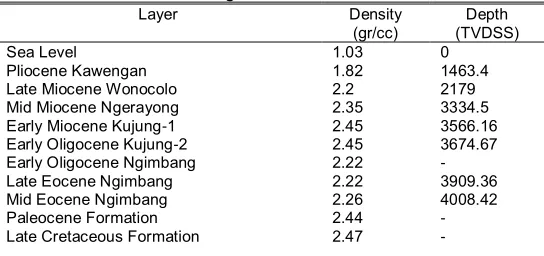
In order to know crustal structure of the area, one gravity model was constructed using the GM-SYS gravity modeling software. The model was constrained by seismic reflection interpretations in the half-part of northern area where seismic data available. Densities were estimated from well data (Baluran-1) obtained from density log. Based on seismic and well data, the model section is assigned to consist of fourteen layers, with a layer of sea water overlying the sedimentary sequence. The average density of each layer and its estimated thickness, as constrained by wells, are given in Table 1.
TABLE 1:
Layer, average density and depth of the gravity model according to Well Baluran-1
Layer Density
(gr/cc)
Depth (TVDSS)
Sea Level 1.03 0
Pliocene Kawengan 1.82 1463.4
Late Miocene Wonocolo 2.2 2179
Mid Miocene Ngerayong 2.35 3334.5
Early Miocene Kujung-1 2.45 3566.16
Early Oligocene Kujung-2 2.45 3674.67
Early Oligocene Ngimbang 2.22 -
Late Eocene Ngimbang 2.22 3909.36
Mid Eocene Ngimbang 2.26 4008.42
Paleocene Formation 2.44 -
Late Cretaceous Formation 2.47 -
Fig 5 – Outcrop of the Oligocene Penggulung Formation showing as deposited in shallow marine to
Basement 2.57 -
Granitic Crust 2.67 -
Upper Mantle 3.07 -
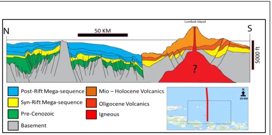
Along the section of the crustal model transect AA’, the thickness of the crust ranges from 23 kilometers in the northernmost and southernmost (near Lombok Island), but thinning approximately 15 km toward the central portion of the seismic transect. On the basis of the thickness of crust, it suggests that the Southern Basin of Lombok is underlain by attenuated continental crust. Gravity model reveals the crustal structure of the eastern part of East Java Sea and shows thinning of the crust up to 15 Km with high gravity anomaly. Toward the north and south of this gravity high with thin crust is low gravity anomalies with thicken crust up to 23 Km. On the basis of crustal thickness, it can be interpreted that continental crust extend to the Lombok island, and thin crust indicated as attenuated of continental crust occurred during extensional period in Eocene age as mostly postulated in East Java [14]. 3.2. Outcrop Observation
From published geological map, the lithology of the Lesser Sunda Islands was mostly covered by volcanic rocks of Miocene age and younger [15]. However, result of field survey in Lombok Island shows a quite interesting age and facies of rocks encountered in Pengulung Formation exposed only in the southern part of Lombok Island with age of Oligocene and even older (Figure 5). The lower part of Pengulung Formation comprises of andesite lava weathered, grey-colored, phaneric and hypocrystalline. Above this lava is several channelized conglomeratic breccias interpreted as channel deposit in fluvial environment. The middle part is mostly volcanic breccia and tuff. Fragments of breccia, including chlorite – zeolite, displayed peperitic structure, which indicates underwater volcanic activity.
Finally, the upper part consists of sandy mudstone and feldsphatic wacke alternations. Older rock than Penggulung
Formation of Oligocene age is not exposed, but it is surely presence in the subsurface. It is important to know that Eocene age or older are presence in Lombok Island as this opposed to the understanding that it is only magmatic arc of Neogene Age only. The implication of the models and interpretation leads to the new understanding that the provenances of potential source rocks and reservoirs are not only derived from northern part of eastern part of East Java Sea Basin as mostly believed previously, but also could come from the southern part towards Lombok Island in Palaeogene.
4.
CONCLUSION
A proper geological understanding of the eastern part of east Java Sea Basin is of paramount importance for proposing the hydrocarbon potential of the area. Since there is no well data in the deep water region (deeper than 1000 m), it can be fully considered as a frontier area. Integrated gravity, well data and field geology demonstrate the crustal structure configuration of the area. Crustal configuration is the key in understanding the tectonic processes occred in the area in relation to basin deformation. Since new model has been proposed in terms of provenance for source rocks and reservoirs, then, the most critical factor for petroleum systems risk analyses can be performed. The provenance could be derived from southern part towards the Lombok Island, and not only from northern part as always assumed, since it is too far from to the area. The result of this study will open new exploration concepts of the eastern part of East Java Sea Basin.
REFERENCES
[1] Satyana, A.H. 2016. The Emergence of Pre-Cenozoic Petroleum System in East Java Basin: Constraints from New Data and Interpretation of Tectonic Reconstruction, Deep Seismic, and Geochemistry. Proceeding of the 40th annual convention of the Indonesian Petroleum Association, (pp.242-255). Jakarta.
[2] Satyana, A.H. 2014a. New consideration on the Cretaceous subduction zone of Ciletuh-Luk Ulo-Bayat-Meratus: Implication for Southeast Sundaland Petroleum Geology. Proceedings Indonesian Petroleum Association, 38th Annual Convention. Jakarta.
[3] Satyana, A.H. 2014b. Tectonic Evolution of Cretaceous Convergence of Southeast Sundaland: a new synthesis and its implications on petroleum geology. Proceedings Indonesian Association of Geologists 43rd Annual Convention. Jakarta.
[4] Satyana, A.H. 2015. Rifting History of the Makassar Straits: New Consideration from Well Penetrating the Basement and Oils Discovered in Eocene Section – Implications for Further Exploration of West Sulawesi Offshore. Proceeding of the 40th annual convention of the Indonesian Petroleum Association. Jakarta.
Basement Character, Structure and Plate Tectonic Development. Proceedings of the 33rd annual convention of the Indonesian Petroleum Association. Jakarta.
[6] Metcalfe, I. 2011a. Palaeozoic-Mesozoic History of SE Asia. In: Hall, R., Cottam, M. and Wilson, M. (Eds.), The SE Asian Gateway: History and Tectonics of Australia-Asia Collision. Geological Society of London Special Publication, 355, 7–35.
[7] Metcalfe, I. 2011b. Tectonic framework and Phanerozoic evolution of Sundaland. Gondwana Research, 19, 3–21. [8] Metcalfe, I. 2017. Tectonic Evolution of Sundaland.
Bulletin of the Geological Society of Malaysia, Volume 63, June 2017, pp. 27-60.
[9] Emmet, P.A., Granath, J.W., and Dinkelman, M.G. 2009. Pre-Tertiary sedimentary ―keels‖ provide insights into tectonic assembly of basement terranes and present-day petroleum system of the East Java Sea. Proceedings of the 33rd Convention of the Indonesian Petroleum Association. Jakarta.
[10] Nico Kueter, Joko Soesilo, Fedortchouk, Y., Nestola, F., Belluco, L., Troch, J., Wälle, M., Guillong, M., Von Quadt, A. & Driesne, T., 2016. Tracing the depositional history of Kalimantan diamonds by zircon provenance and diamond morphology studies. Lithos, 265, 159-176.
[11] White, L.T., Graham, I., Tanner, D., Hall, R., Armstrong, R.A., Yaxley, G., Barron, L., Spencer, L. & van Leeuwen, T.M., 2016. The provenance of Borneo's enigmatic alluvial diamonds: A case study from Cempaka, SE Kalimantan. Gondwana Research, 38, 251-272.
[12] Granath, J.W., Christ, J.M., Emmet, P.A. and Dinkelman M.G. 2011. Pre-Cenozoic sedimentary section and structure as reflected in the JavaSPANTM crustal-scale PSDM seismic survey, and its implications regarding the basement terranes in the East Java Sea. Geological Society London Special Peblication 355(1):53-74, June 2011.
[13] Letouzey, J., Werner, P., AND Marty, A., 1990, Fault reactivation and structural inversion. Backarc and intraplate compressive deformations. Examples of the eastern Sunda shelf (Indonesia): Tectonophysics, v. 183, p. 341–362.
[14] Hall, R. 2012. Late Jurassic–Cenozoic reconstructions of
the Indonesian region and the Indian
Ocean. Tectonophysics, 570, 1-41.
[15] H