INTRODUCTION
Morphological analysis is a research method that is widely used in many branches of science: hydrology [Lenar-Matyas et al. 2015, Głowski et al. 2007], ecology, biology, geodesy and cartogra-phy, geology, medicine, urban geography [Radin-sky 1985, Caër and Delannay 1993, Bejan 2000], spatial planning and land management [Stręk 2019]. In geodesy and cartography the concept of mathematical morphology means a method of analyzing spatial structures based on images obtained from remote sensing devices. The term ”morphology” means the study of the geometric properties of objects in space, whereas ”math -ematical” indicates using mathematical tools for this purpose, which come from such areas as: set theory, topology, and stochastic geometry (geometric probability in particular) and lattice theory [Kupidura at al 2010, Serra 1982, Ha -ralick et al. 1987]. Research in urban geography
is focused mainly on determining the phases of morphological development of urban blocks or the parts of cities [Szmytkie 2014]. It is therefore historical research combined with cartographic analysis. Studies conducted in recent years have shown that morphological analyzes of digital cadastral maps, consisting in examining the geo-metrical properties of structures formed by the boundaries of cadastral parcels provide infor-mation on the level of urbanization of the areas studied [Fialkowski and Bitner 2008].
The paper presents the morphological analy-sis of the cadastral map of the area bordering the river in the village of Strzelce Wielkie. River valleys are areas of great natural value. They are often the only refuges of biodiversity in areas transformed by human activities. They consti-tute ecological corridors in these areas. Natural river valleys have specifically developed geo -morphological and hydrological systems. Some of the biggest threats to the natural values of river
Accepted: 2020.06.26 Available online: 2020.07.01 Volume 21, Issue 6, August 2020, pages 36–41
https://doi.org/10.12911/22998993/123119
A Distinctive Shape of Cadastral Parcels Bordering
the Młynówka River in Strzelce Wielkie
Agnieszka Bitner
1*, Urszula Litwin
1, Stanisław Bacior
1,
Jarosław Taszakowski
1, Karol Król
1, Paweł Basta
11 Faculty of Environmental Engineering and Land Surveying, Department of Agricultural Land Surveying,
Cadaster and Photogrammetry, University of Agriculture in Krakow, Balicka 253a, 30-198 Krakow, Poland * Corresponding author’s e-mail: rmbitner@cyf-kr.edu.pl
ABSTRACT
Morphological analysis is a widely used method, applied in many scientific disciplines: ecology, biology, hydrol
-ogy, geodesy and cartography, geol-ogy, medicine, and in urban geography. The term “morphology” has different meanings in different disciplines. In geodesy and cartography it means, generally speaking, studying the geomet
-ric properties of objects in space. In this research a digital cadastral map was submitted for analysis. This paper
presents the morphological analysis of the structure created by the borders of cadastral parcels located in Strzelce
Wielkie. In particular, the relationship between the perimeter and the area of the parcels bordering the Młynówka River flowing through the village was determined. The analysis indicates that a typical parcel situated on the Młynówka River has a significantly elongated shape similar to the shape of parcels located in urban areas. The calculated coefficient of parcel shape demonstrates that parcels bordering the river are seen as attractive and that the river bank is used in the most optimal way.
valleys are drainage systems and intensive farm-ing resultfarm-ing in soil desiccation and movfarm-ing the border of agricultural land towards the riverbed [Wróbel 2010, Bytyqi et al. 2019]. It is the case in the village of Strzelce Wielkie.
The village of Strzelce Wielkie is located in the Młynówka River valley, in the municipality of Szczurowa, in the Lesser Poland Voivode-ship. The foundation of Strzelce Wielkie dates back to the 11th century. At that time there were extensive forest complexes in those areas. The name of the village is derived from the settle-ment of riflemen, who in the times of the king Władysław Łokietek used to hunt in those ar -eas and supplied wild game meat to the court in Kraków. One of the oldest historical monuments is a 19th century manor, where today the hunt -ing club ”Nadwiślan” is located and the parish church of St. Sebastian, which was built in 1785. Currently, most of the 823 inhabitants (accord -ing to the 2011 National Population and Hous -ing Census) of the village make a liv-ing from farming, thanks to the mild climate, relatively flat terrain and the high value agricultural land. The development of the municipality is strongly influenced by the proximity to two large cities, Tarnów and Kraków, and of the A-4 motorway. There are twenty one villages in the municipal-ity, Strzelce Wielkie being the oldest of them.
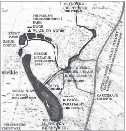
The Młynówka River was of major impor -tance in the shaping of the spatial distribution of Strzelce Wielkie. Originally, the Młynówka River was a natural water reservoir for the in-habitants of Strzelce Wielkie. Flowing through manorial grounds, it fed numerous ponds (Fig. 1) [Augustynek el al. 2015]. In the 20th century, due to drainage, the river lost its tributaries and practically dried up. The pumping station built in the final section of the river was also closed. Its task was to protect the residents against the „backwater” phenomenon consisting in marine waters being pushed into the Vistula River dur-ing floods.
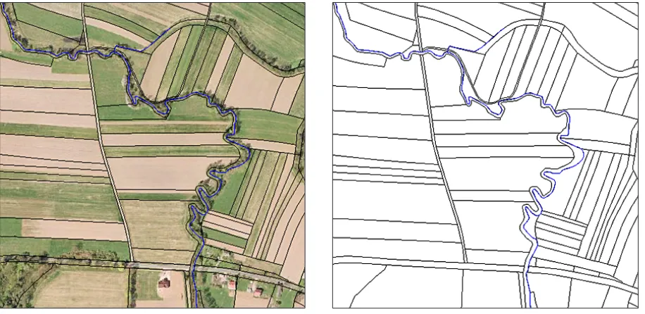
Currently, the area under study is very much neglected; most of the Młynówka riverbed is dry or marshy, the river being today only rainwater-fed. The banks, slopes and embankment are un -protected and obstructed culverts prevent the river from functioning property (Fig. 2). Due to the lack of any cleaning works, many self-seeding plants are visible. Of the numerous ponds, only the largest one is in good condition, the remaining ones, due to lack of water supply, became over -grown and got covered with mud.
Because of the historical significance of the Młynówka River in the development of the area studied the morphological analysis of parcels bordering the Młynówka River was carried out.
Figure 1. Characteristic compositional elements of Strzelce Wielkie centre in the middle of the 19th century and the communication systems – the linear and the
Parcel boundaries are the most durable signs of human activity [Bitner et al. 2009], therefore morphological analysis of parcels can provide ad-ditional information about the area under study.
METHODS
Data for the morphological analysis of par -cels bordering the Młynówka River were ob -tained from a map in the DGN format, which presented the village of Strzelce Wielkie. Based on that map, the areas and perimeters of the par-cels directly bordering the Młynówka River were
measured in MicroStation V8i – from the source of the river until its end, when it reaches the pumping station that pumps water into the Vis-tula River. The lengths of the sides of the parcels bordering the river were also measured. Parcels that were roads were removed from the analysis. Those parcels were identified using the Geoportal. gov portal (Fig. 3) and during the site visit. The area under consideration included built-up land as well as agricultural land, wooded land and land covered with bushes. In the area under study 179 parcels bordered the Młynówka River. Summary information about the basic measures describing parcels is presented in Table 1.
Figure 2. The current state of the Młynówka River
Figure 3. Fragments of the orthophotomap with the boundaries of cadastral parcels
RESULTS AND DISCUSSION
The relationship between area and perimeter was determined using the method described in the paper [Bitner 2011]. The analysis included 179 par -cels with areas ranging from 167 m2 to 31466 m2. In the applied method the assumption was made that the following allometric relationship occurs between area and perimeter:
L = ASβ (1)
where: L – parcel perimeter,
S – parcel area, β – exponent value,
A – proportionality constant – are positive real numbers.
After taking the logarithm of both sides of the equation (1) we get the following relation: ln L = α + β ln S, (2) where: α = ln A.
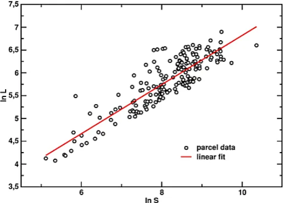
Figure 4 shows the relationship between the logarithm of parcel perimeter, L, and the
logarithm of parcel area, S. The results refer to parcels bordering the Młynówka river located in the village of Strzelce Wielkie. The straight line of best fit to the series of data points in Figure 4 was generated using the least squares method in the model determined by the equation (2).
The values of the parameters α and β obtained from the least squares fitting are α = 1,436 ± 0,184 and β = 0,538 ± 0,023, with the coefficient of determination R2 = 0,763. It means that the sta -tistical dependence of parcel perimeter on parcel area in the village of Strzelce Wielkie obeys with a good approximation the following relation:
L = A√𝑆𝑆, (3)
𝜂𝜂 =𝐿𝐿+√𝐿𝐿𝐿𝐿−√𝐿𝐿22−16𝑆𝑆−16𝑆𝑆 (6)
(3)
The analysis of the areas and perimeters of cadastral parcels can provide other important in-formation that concerns the characteristic shape of the parcels. During the analysis of the cadastral map of the village of Strzelce Wielkie it has been found out that the parcels are good approxima-tions of rectangles. To quantify the shape of a par -cel we employed the parameter η calculated as the ratio of the two parcel’s sides:
Table 1. Summary information about areas and perimeters of parcels located in Strzelce Wielkie
Strzelce Wielkie Parcel area [m2] Parcel perimeter [m]
Min 167 59
Max 31466 990
Average 4690 381
Number of parcels 179
Figure 4. Dependence of the natural logarithm of parcel perimeter, L, on the natural logarithm of parcel area, S, for the parcels bordering the Młynówka river in the village of Strzelce Wielkie.
Parcel areas are expressed in [m2], and parcel perimeters - in [m]. The straight line (marked
η = b/a, η ≥ 1 (4) where: a and b denote the lengths of the two sides
of the parcel of interest.
Under the assumption that the shape of the parcel can be well approximated by a rectangle, the lengths a and b of the parcel are linked by the following set of equations:
S = ab, (5a)
L = 2(a+b), (5b)
The lengths of the sides a and b of a parcel can be determined from the equations (5a) and (5b) based on its area, S, and perimeter, L. The pa-rameter η introduced in Eq. (4) is then expressed in terms of S and L by the following relation:
L = A√𝑆𝑆, (3)
𝜂𝜂=𝐿𝐿+√𝐿𝐿𝐿𝐿−√𝐿𝐿22−16𝑆𝑆−16𝑆𝑆 (6) (6)
For each parcels bordering the Młynówka riv -er the paramet-er η was determined from Eq. (6) based on its area, S, and the perimeter, L. The av-erage value of the parameter η was calculated as:
η = 7.903 ± 0.573
Additionally, for each parcel bordering the Młynówka River, the values of the parameter η were determined for each parcel using different method. Within this approach, the length of the side adjacent to the river – denoted here as a – was measured directly from the cadastral map. Then, the second side, b, was calculated from the relation:
b = S/a. (7) The parameter η = b/a (η ≥ 1) was then deter -mined from the formula:
η = S/a2. (8) The average value of the parameter η calcu -lated using the second method was found to be
η = 8.957 ± 1.048
The values of coefficient η obtained with two different methods are therefore comparable. However, the coefficient value determined with the second method is more accurate because it is based on the actual length of the parcel side. Finally, it was assumed that the value of the coef-ficient η approximately equals to 9. It means that typical parcels bordering the Młynówka River have the shape of elongated rectangles with the ratio of the sides equal to 1:9. The obtained result is surprising because the shape of the analyzed
parcels located in the village of Strzelce Wielkie is comparable to the result presented in the work [Bitner 2011] referring to highly urbanized areas. The cited publication characterizes the typical shape of plots located in the following five cit -ies: Kraków, Zakopane, Starogard Gdański, By -tom and Malmö Sweden. In the five urban areas a typical parcel is a rectangle in which the ratio of the sides is approximately equal to 1:8.
CONCLUSIONS
The morphological analysis of the structure of cadastral parcels bordering the Młynówka River in the village of Strzelce Wielkie presented in this article allowed determining the charac-teristic shape of the parcels located in that area. The Młynówka River was of major importance in shaping the spatial distribution of the village of Strzelce Wielkie. Originally, the Młynówka River was a natural water reservoir for the inhabitants of Strzelce Wielkie: Flowing through manorial grounds, it fed numerous ponds. Today, mainly as a result of drainage, the river lost its tributaries and practically dried up, but the structure created the boundaries of parcels, has survived to this day. Parcel boundaries are the most durable signs of human activity; therefore the morphological analysis of parcels provided additional informa-tion about the area under study.
The analysis revealed that the parcels within the study area have the shape of elongated rect-angles. The ratio of the length of the sides of these rectangles is approximately equal to 1:9. The ob -tained result is surprising because it shows that the shape of typical parcels in the area bordering the Młynówka River is similar to the shape of parcels in urbanized areas. The results lead also to the conclusion that the direct proximity to the river was important for the delimitation of parcel boundaries in the village of Strzelce Wielkie. The significantly elongated shapes of parcels, whose shorter sides are usually adjacent to the river, suggest that during the land division efforts were made to ensure that the largest possible number of plots bordered the river.
Acknowledgments
from the project ”Organization of the 9th Inter -national Scientific and Technical Conference en -titled Environmental Engineering, Photogramme-try, Geoinformatics – Modern Technologies and Development Perspectives”.
REFERENCES
1. Augustynek E., Baster P., Doroż A., Klich M., Piszcz C. 2015. Usage of geodetic materials in multistage landscape revitalization project process of Strzelce Wielkie village. Geomatics, Landmanagement and Landscape, (4), 7–16.
2. Bejan A., 2000. Shape and Structure, From Engi
-neering to Nature. Cambridge University Press, Cambridge.
3. Bitner A., Hołyst R. i Fiałkowski M., 2009. From
complex structures to complex processes: Percola-tion theory applied to the formaPercola-tion of a city.
Physi-cal Review E, 80(3), 037102.
4. Bitner A., 2011. Characteristic shape of land parcels on the urbanized areas – the analysis of morphologi -cal structure of a city. Acta Scientiarum Polonorum
- Geodesia et Descriptio Terrarum, 10(1), 23–32 (in
Polish).
5. Bytyqi V., Ramadani I., Agaj T. 2019. Challenges of
soil resource protection: a case study from Sitnica river basin (Kosovo). Journal of Ecological
Engi-neering, 20(6), 215–224.
6. Caër G.L., Delannay R., 1993. The administrative divisions of mainland France as 2D random cellular structures. J Phys I France, 3, 1777–1800.
7. Fiałkowski M., Bitner A., 2008. Universal rules for
fragmentation of land by humans. Landscape
Ecol-ogy, 23, 1013–1022.
8. Głowski R., Kasperek R., Parzonka W., Wiatkowski
M. 2007. Estimation of morphological changes of
the Odra river valley in meandering sector between Chałupki and the Olza river mouth after 1997 flood. Archives of Environmental Protection, 33(1), 67–74. 9. Haralick R.M., Sternberg S.R., Zhuang X. 1987. Im
-age analysis using mathematical morphology. IEEE Transactions on Pattern Analysis and Machine Intel
-ligence, 9(4), 532–550.
10. Kupidura P., Koza P., Marciniak J., 2010. Math
-ematical morphology in remote sensing. Scientific
Publishers PWN, Warsaw. (in Polish).
11. Lenar-Matyas A., Korpak J., Mączałowski A. 2015. Influence of extreme discharge on restoration works in mountain river – a case study of the Krzczonówka
river (southern Poland). Journal of Ecological
En-gineering, 16(3), 83–96.
12. Radinsky L.B., 1985. Approaches in evolutionary
morphology: A search for patterns. Annual Review
of Ecology and Systematics, 16, 1–14.
13. Serra J., 1982. Image analysis and mathematical
morphology, Vol. 1. Academic Press, Londyn.
14. Stręk Ż., 2019. The impact of the construction of the A4 motorway on the size of plot patchwork within the territory of the village of Czarna Sędziszowska – A case study. Journal of Ecological Engineering, 20(4), 231–238.
15. Szmytkie R., 2014. Methods of morphological and physiognomic analysis of settlements. Scientific Dissertations of the Institute of Geography and Re
-gional Development, University of Wroclaw (35)
(in Polish).