9
I. INTRODUCTION
Advanced driver assistance system (ADAS) means a system that assists the driver in driving. Lane departure warning system means a system that informs the driver when the vehicle leaves the lane, by means of visual, audible, or vibration. It does not be warned when the driver changes lanes or when the flashing signal is switched on [1], [2]. Types of sensors for lane detection are vision sensors, laser sensors, infrared sensors, and so on. This technology was first introduced to the vehicle in 2000 and has since been actively introduced into the manufacturing of some of the latest Advanced Operating System supported models, such as Nissan, Toyota, Honda, Audi, General Motors and Mercedes – Benz.
At present, collision warning using radar rather than vision systems was studied first by the lane keeping system. This is to use the radar to estimate the distance to the vehicle ahead and the speed of the vehicle to estimate the likelihood of a collision, with which the pick-up warning system has many drawbacks. In particular, distance information to the direction aimed by radar is consistent with the direction of travel of the vehicle in which it is intended to be highly accurate, or where it is different from the direction of progress of the actual vehicle, or where it is not intended to be on a road ahead.
Currently, autonomous vehicles with vision systems are first commercialized in Japan, but due to limitations in image noise rejection, the concept of an automatic system that makes it difficult for drivers to create an AVAS, or an AVS Research is
actively being carried out on how to prevent accidents by identifying vehicles nearby in advance in order to prevent lane departure, which is the cause of most traffic accidents.
Recent studies have suggested video processing techniques to separate lanes, vehicles, and obstacles from road images obtained in a complex environment such as urban roads. In other words, techniques from video processing techniques to automotive identification and tracking and collision avoidance are also proposed. Sensors such as laser, radar, ultrasonic waves, and infrared rays are used to detect nearby terrain information and obstacles. Detection of the vehicle is essential for safe driving in vehicle driving aids. Research related to this is receiving much attention and various detection algorithms has been proposed. However, the vehicle areas in which vehicles are present shall be extracted from a complex road image to increase the efficiency of the vehicle detector.
Model-based vehicle area extraction techniques, which assume a combination of typical straight lines and curves, are resistant to noise and loss of lane information. However, it is not suitable for detecting vehicle areas in any roadway type because it is focused on a particular type of road. To resolve the above issues, a technique has been proposed to extract the vehicle area from lane detection using the B-snake technique, which applies both straight and curved roads.
It was also suggested that lane detection techniques be used to disting9uish between the color and the width information that roads and lanes have. Many studies proposed that the method extract the area of road that is the vehicle area from lane detection using Hough transform, a technique that detects linear components within the video. Hough transform is known as an
A Survey of Real-time Road Detection Techniques Using Visual
Color Sensor
Gwang-Soo Hong
1, Byung-Gyu Kim
2*, Debi Prosad Dogra
3, Partha Pratim Roy
4Abstract
A road recognition system or Lane departure warning system is an early stage technology that has been commercialized as early as 10 years but can be optional and used as an expensive premium vehicle, with a very small number of users. Since the system installed on a vehicle should not be error prone and operate reliably, the introduction of robust feature extraction and tracking techniques requires the development of algorithms that can provide reliable information. In this paper, we investigate and analyze various real-time road detection algorithms based on color information. Through these analyses, we would like to suggest the algorithms that are actually applicable.
Key Words: Imaging Sensor, Smart Car, Color Model, Color Segmentation, Road Detection.
Manuscript received February 13, 2018; Accepted February 19, 2018. (ID No. JMIS-2018-0006)
Corresponding Author (*): Byung-Gyu Kim, Dept. of IT Engineering, Sookmyung Women’s University, Seoul, Korea, Tel: 82-2-2077-7293, [email protected].
1Dept. of Computer Engineering, SunMoon University, Asan, Korea, [email protected] 2* Dept. of IT Engineering, Sookmyung Women’s University, Seoul, Korea , [email protected] 3IIT Bhubaneswar, India, [email protected]
10 efficient way to detect pixels listed as a straight line within an
image. However, detection of the vehicle road area with a normal Huff transformation is only well applied if the background information in the road image is simple. Road images with complex and diverse backgrounds, such as urban roads, are difficult to estimate the exact area of the road because of the complicated information on the edges.
This paper is composed as followings: Various robust road feature analysis and recognition technologies based on color are discussed in Section 2. Finally, we will make a conclusion in Section 3.
II. RELATED WORKS ON ROAD
DETECTION WITH COLOR
INFORMATION
This section describes the techniques used to detect roads according to color space. Since the road areas are different colors from the background, color-based road areas can be detected. 2.1. Robust Color model on illumination change
When an image of the model is given as RGB, the HSV component of RGB image is obtained using the following formula [3].
H = { θ, B ≤ G,
360 − θ, B > G. (1) θ = {
1
2[(𝑅−𝐺)]+[(𝑅−𝐵)]
[((𝑅−𝐺)2+(𝑅−𝐵)(𝐺−𝐵)12)]
} (2)
S = 1 − 3
(𝑅+𝐺+𝐵)[min(𝑅, 𝐺, 𝐵)] (3)
V = 1
3(𝑅 + 𝐺 + 𝐵). (4)
Fig. 1. HSV color space.
RGB values are normalized to the [0, 1] range, and it is assumed that the angle θ is measured based on the red axis in the HSV space. The color can be normalized to the range of [0, 1] by dividing all the values obtained from Equation (1) by 360∘.
2.2. Color-based Road Detection
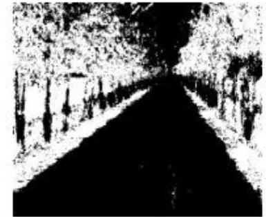
Rural roads are very complex and it is difficult to find their edges or features clearly, and it is not easy to find them using gray images. As in other papers, road detection is carried out using a HIS color model, where the brightness component can be
separated separately. From the original images in Figure 2 (a), Figures 2 (b), (c), and (d) are photographs of each component of the HIS taken separately. When you look at the picture of the ingredients, you can see that I, the brightness component, best represents the road. Detection of roads using the brightness component I is the complete opposite of other papers. In this paper, only the I-component was used and improved Fuzzy C-Means (FCM) has been employed to detect the road region [4].
Fig. 2. HSV color components of real road image. The suggested FCM algorithm is as the following: Step 1. Based on the average gray values of N areas divided in the images computed by the FCM algorithm
Step 2. Locate areas where the grey values change significantly. Here, 𝐶𝑛 denotes illumination value of each region and
𝐶 is the average illumination, respectively. 𝐶𝑛= (
1
𝑐∑ ‖𝑥𝑖− 𝑥‖ 2 𝑐−1
𝑖=0 )
1 2
, 𝐶 = (1
𝑁∑ 𝐶𝑛 𝑁−1
𝑛=0 ) (5)
With Eq. (5), areas in which the grey value satisfies the 𝐶𝑛 ≥
α∙ 𝐶 are considered as true road areas.
Step 3. All N areas are computed by the FCM algorithm until the condition is satisfied.
Fig. 3. The result of the improved FCM.
11 Fig. 4. Crossover structure of genetic programming.
Fig. 5. Mutation of genetic programming.
In Figure 5, mutation operation is illustrated in genetic programming. Each node that forms the tree represents a function (Figure 4) or terminal (Figure 4: constants and variables), and each object is composed of a set of functions. The actions of the mating (Figure 4) and the mutation operator (Figure 5) at GP for the subtree are replaced with the subtree at the selection point. The terminals used for the conversion operation use the values of R, G, B, I1, I2, I3, Y, Cb, Cr, H, S, L, L ∗, a ∗, b ∗ and the total
converted values of channel is in [0, 1]. It uses a total of 16 terminals including random values between [0, 1].
(a)Original, (b)RGB space, (c)HSV space, (d)GP method Fig. 6. Results by segmentation in RGB space, HSV, and GP method.
(a)Original, (b) RGB space, (c) HSV space, (d) GP method
Fig. 7. Results by segmentation in RGB space, HSV, and GP method.
Figures 6 and 7 show some results by segmentation in RGB and HSV color spaces, GP method. From these results, the GP method get the better result than other color space model. GP technique can check exact detection results, except for the noise present in the image with darker brightness for the learned color, but for those that are not learned, it cannot detect some regions according to their brightness areas.
2.3. Road Detection Using Region Splitting
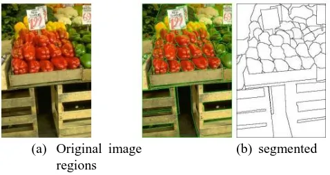
The human brain unconsciously carries out image segmentation to understand scenes. Many problems with computer vision also require high quality video segmentation. Image search, object tracking, face recognition, augmented reality, and gesture recognition can be solved more than half as long as the segmentation is carried out successfully.
(a) Original image (b) segmented regions
Fig.8. An example of image region segmentation. Splitting of normal natural images, such as Figure 8, is a very difficult problem. The split expression of the input image f may be defined by equation (6) [6]-[8].
{
ri∩ 𝑟𝑗= ∅ ≤ 𝑖, 𝑗 ≤ 𝑛, 𝑖 ≠ 𝑗
∪ 𝑖=1, 𝑛 𝑟𝑖= 𝑓
𝑞(𝑟𝑖) = 𝑇𝑟𝑢𝑒 , 1 ≤ 𝑖 ≤ 𝑛
𝑞(𝑟𝑖∪ 𝑟𝑗) = 𝐹𝑎𝑙𝑠𝑒, 1 ≤ 𝑖, 𝑗 ≤ 𝑛,
𝑟𝑖𝑎𝑛𝑑 𝑟𝑗𝑎𝑟𝑒 𝑛𝑒𝑖𝑔ℎ𝑏𝑜𝑟𝑖𝑛𝑔 𝑟𝑒𝑔𝑖𝑜𝑛𝑠.
(6)
Here ri is the i-th area obtained from segmentation and n is the
12 not overlap each other, and the second is the demand that all areas
cover the entire image. The third equation q(ri) is a condition
function that all pixels belonging to an area ri must have the
same characteristics (similar business cards). So, the third and the fourth expressions are that it is a requirement that pixels belonging to the same area should have the same characteristics and that neighboring areas have different characteristics.
Figure 9 shows the connectivity in image segmentation [9]-[10]. Indicates the properties connected to pixel values of the same characteristic in the centered circle image. Image segmentation algorithms are constantly evolving and developing more than ever before, but they limit their practicality under unrestricted circumstances. Many currently deployed application systems use more local features than areas. However, when one recognizes, one uses domain information, not local characteristics.
Fig. 9. Various types of the connectivity.
2.4. Clustering-based Segmentation
In the case of color images, pixels can be mapped to three-dimensional space. Figure 11 shows the mapped result. The dots floating in the 3-dimensional space will be closer to each other as the colors are similar. Color division can be carried out using these properties. The representative approach is data clustering mechanism [11]-[13].
(a)Color image (b) color distribution Fig.10. The RGB space of a color image.
The CAMShift algorithm uses MeanShift's shortcomings with a technique to self-size search windows to improve the MeanShift algorithm in the Color Segment method for use in the tracking environment [14], [15].
Used to track objects at high speed and have poor performance in light-change, noisy backgrounds. Using the distribution of Hue values in the areas of the detected object, the location to be changed is predicted and detected, and then the object is centrally tracked.
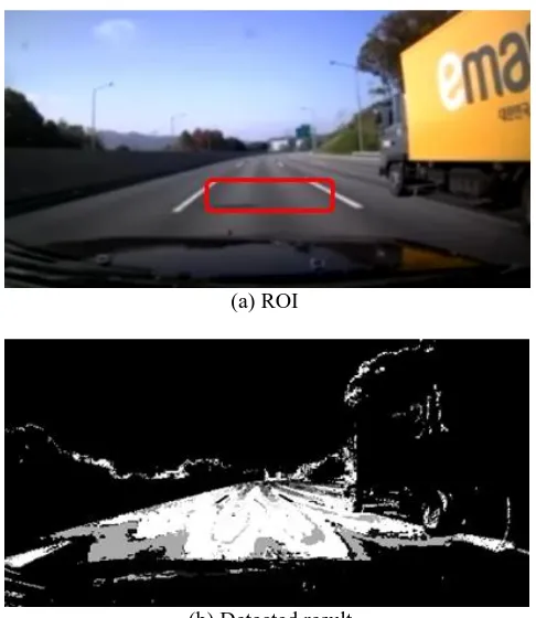
Once a region of interest (ROI) is given, it converts to the Hue value of the SHV color model, builds, stores, and uses a 1-dimensional histogram of the areas of interest. It is used by setting several windows within the image and by repeatedly changing the size and position of each window's center point, where the position of the pixels within the window is averaged separately for the pixel values to be averaged.
This process is repeated until the windows are assembled, and whether or not the windows are collected is determined by a change in the location and size of the windows. That is, the changed window will converge when its position and size do not differ from the previous value. When all windows in an area are clustered, the maximum window output can vary. Figure 11 shows a result by CAMshift algorithm.
(a) ROI
(b) Detected result
Fig. 11. The road candidates detection by CAMshift algorithm.
V. CONCLUSION
In this paper, video processing techniques were investigated on a color-based basis to separate lanes, vehicles, and obstacles from road images obtained in a complex setting, such as a city road. From our analysis, we need to choose the right color space, first, because it can be insensitive to the variety of lighting changes. Also we should define some prior knowledge such as the region of interest (ROI). With these information, we have to develop the color segmentation or merging algorithm to suppress some noise components. The geometric structure of camera view can be also recommended in the detection system.
Acknowledgement
Authors would like to thank all reviewers and staff members of the JMIS for qualifying our paper in the peer-to-peer review process.
REFERENCES
13 "Vision-based road detection via on-line video registration." International IEEE Conference on Intelligent Transportation Systems (ITSC), pp.1135 - 1140, 2010.
[2] J.M.A. Alvarez, T. Gevers, A.M. Lopez. "Vision-based road detection using road models." IEEE International Conference on Image Processing (ICIP), pp.2073 - 2076, 2009.
[3] J. Lu, M. Yang, H. Wang, B. Zhang. "Vision-based real-time road detection in urban traffic." International Society for Optics and Photonics, pp.75-82, 2002. [4] Sivic, Josef, Andrew Zisserman. "Video Google: A text
retrieval approach to object matching in videos." International Conference on Computer Vision, vol.2, pp.1470-1477, 2003.
[5] H. Dahlkamp, A. Kaehler, D. Stavens, S. Thrun, G. Bradski. "Self-supervised Monocular Road Detection in Desert Terrain.", Robotics: science and systems. 2006.
[6] J.M.A. Alvarez, T. Gevers, Y. LeCun, A.M. Lopez. "Road scene segmentation from a single image.", European Conference on Computer Vision (ECCV), pp. 376-389, 2012.
[7] J.M.A. Alvarez, J. Lopez, M. Antonio. "Road detection based on illuminant invariance.", IEEE Transactions on Intelligent Transportation Systems, vol.12 , pp.184-193 , 2011.
[8] J.M.A. Alvarez, M. Salzmann, N. Barnes. "Large-scale semantic co-labeling of image sets", IEEE Winter Conference on Applications of Computer Vision (WACV), pp.501-508, 2014.
[9] Hui Kong, J.Y. Audibert, J. Ponce. "General Road Detection From a Single Image", IEEE Transactions on Image Processing, vol.19, pp.2211-2220, 2010. [10] Bai, Li, Yan Wang, Michael Fairhurst. "An extended
hyperbola model for road tracking for video-based personal navigation." Knowledge-Based Systems, pp.265-272, 2008.
[11] J.M.A. Alvarez, T. Gevers, A.M. Lopez. "3D Scene priors for road detection", 2010 IEEE Conference on Computer Vision and Pattern Recognition (CVPR), pp.57-64, 2010.
[12] T. Kuhnl, J. Fritsch. "Visio-spatial road boundary detection for unmarked urban and rural roads", IEEE Intelligent Vehicles Symposium Proceedings, pp.1251-1256, 2014.
[13] F. Diego, J.M.A. Alvarez, J. Serrat, A.M. Lopez. "Vision-based road detection via on-line video registration", International IEEE Conference on Intelligent Transportation Systems (ITSC), pp.1135-1140, 2010.
[14] J.M.A. Alvarez, T. Gevers, A.M. Lopez. "Vision-based road detection using road models" IEEE International Conference on Image Processing (ICIP), pp.2073-2076, 2009.
[15] Katramados, Ioannis, Steve Crumpler, Toby P. Breckon. "Real-time traversable surface detection by color space fusion and temporal analysis", International Conference on Computer Vision Systems, (ICVS), pp.265-274, 2009.
Authors
Gwang-Soo Hong received his BS and MS degrees in the Department of Computer Engineering from SunMoon University, Korea, in 2011 and 2013, respectively. In 2013, he joined the Department of Computer Engineering for pursuing his PhD degree at SunMoon University. His research interests include image coding algorithms, video coding technique and depth estimation algorithms in stereo vision.
Byung-Gyu Kim has received his BS degree from Pusan National University, Korea, in 1996 and an MS degree from Korea Advanced Institute of Science and Technology (KAIST) in 1998. In 2004, he received a PhD degree in the Department of Electrical Engineering and Computer Science from Korea Advanced Institute of Science and Technology (KAIST). In March 2004, he joined in the real-time multimedia research team at the Electronics and Telecommunications Research Institute (ETRI), Korea where he was a senior researcher. In ETRI, he developed so many real-time video signal processing algorithms and patents and received the Best Paper Award in 2007.
From February 2009 to February 2016, he was associate professor in the Division of Computer Science and Engineering at SunMoon University, Korea. In March 2016, he joined the Department of Information Technology (IT) Engineering at Sookmyung Women’s University, Korea where he is currently an associate professor.
In 2007, he served as an editorial board member of the International Journal of Soft Computing, Recent Patents on Signal Processing, Research Journal of Information Technology, Journal of Convergence Information Technology, and Journal of Engineering and Applied Sciences. Also, he is serving as an associate editor of Circuits, Systems and Signal Processing (Springer), The Journal of Supercomputing (Springer), The Journal of Real-Time Image Processing (Springer), Helyion Journal (Elsevier), and International Journal of Image Processing and Visual Communication (IJIPVC). From 2018, he is serving as the Editor-in-Chief (EiC) of the Journal of Multimedia Information System. He also served as Organizing Committee of CSIP 2011 and Program Committee Members of many international conferences. He has received the Special Merit Award for Outstanding Paper from the IEEE Consumer Electronics Society, at IEEE ICCE 2012, Certification Appreciation Award from the SPIE Optical Engineering in 2013, and the Best Academic Award from the CIS in 2014. He has been honored as an IEEE Senior member in 2015.
14 Dr. Debi Prosad Dogra (M’06)
obtained Ph.D. degree from IIT Kharagpur, India in 2012, M.Tech degree from IIT Kanpur, India in 2003, and B.Tech from Haldia Institute of Technology, India in 2001. Presently, he is an Assistant Professor in the School of Electrical Sciences, IIT Bhubaneswar, India. He was with Samsung Research India (2011-2013). He worked with ETRI, South Korea (2006-2007). He worked as a faculty at HIT (2003-2006). He has published more than 50 research papers in international journals and conferences. His research interests include visual surveillance, augmented reality and human computer interface. He has obtained three US patents.