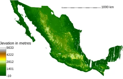
Managing Large Geodatasets for Urban Flood Risk Mapping: The Mexican Flood Risk Atlas
Full text
Figure


Related documents
These factors apply both to the case of neural binding, in which the activity of disparate neuronal populations or networks must be combined and maintained (e.g., corresponding
The purpose of present research was to examine student retention and persistence along with the role of student engagement on that process as defined by the National Survey of
Adjacent protected areas: Øvre Pasvik Protected Landscape Area, Pasvik Nature Reserve (RAMSAR), Pasvik Zapovednik (nature reserve in Russia) and Vätsäri Wilderness
Indeed, under all scenarios law firms will need to assess how much and what type of talent they need in future and how they will attract, develop, retain and change talent to
It seems reasonable to use informal types of assessment in the very young learner context (rather than formal assessment) as non-linguistic factors are an essential part of
The forecasting scenarios provide evidence suggesting that a 5% improvement in the efficient use of electricity, as proxied by a decrease in the elasticity of
Ostvarene investicije u nova stalna sredstva prema djelatnosti investitora i namjeni investicija (EU NACE Rev.1.1) u 2007.. Ostvarene investicije u nova stalna sredstva prema
• The proposed rules separate the taxation of income from a life insurance business into that earned by the equity owners of the company (shareholder income), and the income
