8th International Symposium of the Digital Earth (ISDE8)
IOP Conf. Series: Earth and Environmental Science 18 (2014) 012034
IOP Publishing doi:10.1088/1755-1315/18/1/012034
Mapping and Analysis of Forest and Land Fire Potential
Using Geospatial Technology and Mathematical Modeling
M D H Suliman13, M Mahmud ', M N M Reba 2 , L W S2.
'Pusat Pengajian Sosial, Pembangunan Dan Persekitaran,Fakulti Sains Sosial dan Kemanusiaan, Universiti Kebangsaan Malaysia, Bangi.
2Universiti Teknologi Malaysia, Skudai
Email : [email protected]
Abstract. Forest and land fire can cause negative implications for forest ecosystems, biodiversity, air quality and soil structure. However, the implications involved can be m inimized through effective disaster m anagem ent system. Effective disaster management mechanisms can be developed through appropriate early warning system as w ell as an efficient delivery system. This study tried to focus on two aspects, nam ely by mapping the potential o f forest fire and land as w ell as the delivery o f inform ation to users through W ebGIS application. G eospatial technology and mathem atical modeling used in this study for identifying, classifying and mapping the potential area for burning. M athem atical models used is the Analytical Hierarchy Process (AHP), while Geospatial technologies involved include remote sensing, Geographic Inform ation System (GIS) and digital field data collection. The entire Selangor state was chosen as our study area based on a num ber o f cases have been reported over the last two decades. AHP modeling to assess the com parison between the three main criteria o f fuel, topography and hum an factors design. Contributions o f experts directly involved in forest fire fighting operations and land com prising officials from the Fire and Rescue D epartm ent M alaysia also evaluated in this model. The study found that about 32.83 square kilom eters o f the total area o f Selangor state are the extreme potential for fire. Extreme potential areas identified are in Bestari Jaya and K uala Langat H igh Ulu. Continuity o f inform ation and terrestrial forest fire potential was displayed in W ebGIS applications on the internet. Display inform ation through W ebGIS applications is a better approach to help the decision-making process at a high level o f confidence and approximate real conditions. Agencies involved in disaster m anagem ent such as Jawatankuasa Pengurusan D an Bantuan Bencana (JPBB) o f D istrict, State and the National under the National Security D ivision and the Fire and Rescue Departm ent M alaysia can use the end result o f this study in preparation for the land and forest fires in the future.
1. Introduction
Land and forest fires in tropical ecosystems are the major environmental problem in Southeast Asia. Forest fires in Southeast Asia happen due to the direct or indirect activities. The cause is usually directly related to human activity that intentionally or unintentionally burn, as well as agents that lead to a fire. Conducted open burning techniques to meet the needs of agriculture, farming, housing construction and commercial center is an example of direct cause. In addition, human activities and negligence involving the use of fire such as throwing cigarette butts in the forest, camping, hunting, fishing and other contribute to the cause directly. Indirect causes of forest fires are as meteorological factors. Climate and weather factors control when a forest fire occurs, in addition to being able to control the frequency. Dryness and moisture are the main parameters related to forest fires. During the months of May to September, Peninsular Malaysia experienced the Southwest Monsoon, where dry
3 To whom any correspondence should be addressed.
8th International Symposium of the Digital Earth (ISDE8) IOP Publishing
IOP Conf. Series: Earth and Environmental Science 18 (2014) 012034 doi:10.1088/1755-1315/18/1/012034 weather conditions accompanied by wind. This condition could be one factor beside others (human negligence, forest clearing for agriculture, etc.) that making fire spread and more difficult to control.Potential areas for burns capable identified with precision and accuracy is through mapping [1]. Geospatial technology consisting o f the integration o f remote sensing technology, Geographic Information System (GIS) and digital data collection, enhanced with the use o f mathematical modeling Analytical Hierarchy Process (AHP). Then, the information potential o f fire is displayed and presented to the user as a Disaster M anagement Committee, the National Security Council and the Fire and Rescue Department M alaysia through W ebGIS application.
2. Study area
The study was carried out in a fire-prone areas. The chosen study area is the entire state o f Selangor, Malaysia. Selangor is located in the W est Coast o f Peninsular Malaysia. Selangor has an area of 796.084 hectares, consists o f 9 districts and 55 parishes. Land use and land cover in Selangor are peat swamp forest, forest plantations, forest land, oil palm, paddy, rubber, coffee, cocoa, coconut, grass, old mines, open space, rural areas and urban areas. Selangor has a uniform temperature which is in the range between 21 ° C to 32 ° C, high humidity and abundant rainfall with annual rainfall, about 2.670 mm. 181.502 hectares or 23% o f Selangor state is composed o f peat and mineral soil remaining. Some o f the locations that have high frequencies o f forest fires identified is in the Bestari Jaya, Ulu Tinggi , Kuala Kubu Bharu, Kuala Langat, Banting, Dengkil and Sepang.
3. M ethodology
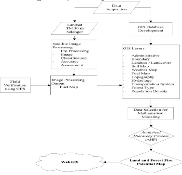
The methodology accounts for the observed GPS field data, satellite image processing, GIS database development, the use o f mathematical models and the development o f WebGIS application. A flowchart o f the methodology o f this study is shown in Figure 1.
IOP Conf. Series: Earth and Environmental Science 18 (2014) 012034 doi:10.1088/1755-1315/18/1/012034 3.1. Satellite image processing
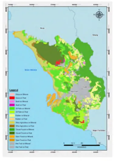
Satellite image processing is carried out to produce the fuel map. Satellite images used are Landsat-7 ETM. Satellite image processing involves pre-processing and image classification. Geometry Correction and Atmospheric Correction are two methods that have been carried out for the preprocessing stage.Eight types of fuel class such as grasses, slash, open forest, closed forest, oil palm, rubber and other agriculture including non-fuel material was classified and the result of the classification of fuel material combined (union) to map of soil types consist of two main classes that are mineral soil and peat soil to form a fuel map that contains the class of sixteen types such as grasses on mineral soils, grasses on peat soil, closed forest on mineral soil, close forest on peat soil, open forest on mineral soil, open forest on peat soil, slash on mineral soil, slash on peat soil, coconut palm on mineral soil, oil palm on peat soil, rubber on the mineral soil, rubber on peat soil, agriculture on mineral soil, agriculture on peat soil, fuel material on mineral soil and non-fuel material on peat soil. Map of fuel material is shown through Figure 2. Comparison map generated through an image classification process the GPS data observations give overall accuracy of 75 percent. W hile in remains error is 0.25, and the error done is 0.01667.
F ig u re 2. Fuel Map in Selangor.
3.2. GIS database development
GIS database developed to facilitate the process of effectively managing GIS data and strategic planning. This is because the GIS data is not only used as a determining criteria for the potential analysis of forest fire, but it is also used as ancillary data to help users decide WebGIS application. GIS database development will expedite the process of data analysis as well as faster data access in the WebGIS application.
3.3. M athematical model
8th International Symposium of the Digital Earth (ISDE8) IOP Publishing
IOP Conf. Series: Earth and Environmental Science 18 (2014) 012034 doi: 10.1088/1755-1315/18/1/012034 specialist assessment o f each criteria for potential forest fire and land is made up o f elected officials form Fire and Rescue Department Malaysia, namely:
I. Tuan Borhan Bin Madon, Penolong Kanan Penguasa Bomba, Bahagian Operasi, Ibu Pejabat Jabatan Bomba dan Penyelamat Malaysia, Putrajaya
II. En. W an Zakaria Bin W an Busu, Pegawai Bomba, Bahagian Operasi, Jabatan Bomba dan Penyelamat Negeri Selangor, Shah Alam
III. En. Mohd Jasni Bin Somidi, Pegawai Penjaga, Balai Bomba Bukit Jelutong, Shah Alam
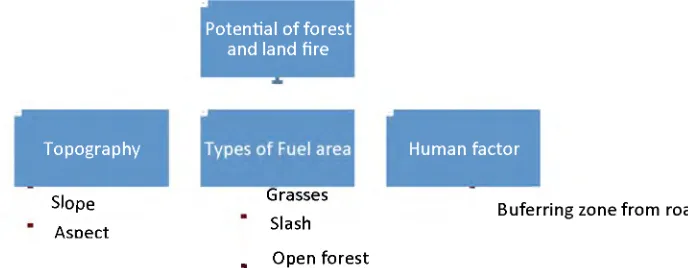
Analytical Hierarchy Process (AHP) is a method used to produce the weight value, after each criteria evaluated by a specialist to determine the potential o f forest fire and land. The most consistent evaluation (lowest degree) will be used as a potential determinant o f forest fire and land in the state. Once the weights obtained by AHP, the output or result can be interpreted spatially connected using the GIS approach. Each raster data are multiplied by the weight value obtained from the method o f AHP, then added all raster data involved in order to generate the final output. Final output is based on the goals or objectives to be achieved in the AHP method. The AHP structure formation begins with the objectives to be achieved, the criteria and sub-criteria. This is illustrated in Figure 3 which shows the hierarchical structure o f the potential o f forest fire and land.
Potential o f forest and land fire
Topography Human factor
Slope
AsDect
Buferring zone from roads Grasses
Slash
. Open forest
Figure 3. A hierarchical structure for potential forest and land fire.
3.4. WebGIS development
WebGIS is used to disseminate information from the analysis of forest fire potential to the user. Information dissemination and achievement levels are very wide, it is based on the technology of the Internet without boundaries. The focus o f WebGIS for this study include potential map o f forest fire and land, the administrative boundary data layer states, counties, cities and parishes in Selangor, land use and land cover, soil type, fuel, temperature, rainfall, relative humidity, elevation models digital (DEM), slope data and the surface data, streams and drainage systems, roads, forest type and population density.
4. Result and analysis
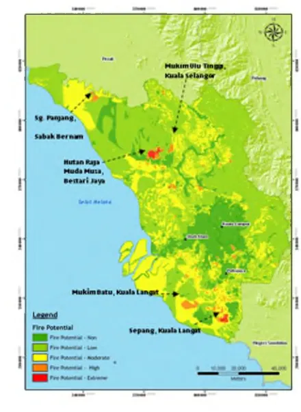
IOP Conf. Series: Earth and Environmental Science 18 (2014) 012034 doi:10.1088/1755-1315/18/1/012034 non-fuel materials. Classification from the high potential forest fire until the no potential at all is very important in this study. Classification is based on the lowest to the highest value in the summation of each raster data that represents the criteria and sub-criteria involved.
Figure 4. Map o f potential forest and land fire in Selangor
The final potential o f land and forest fire map is published on WebGIS application. WebGIS is equipped with spatial information such as maps o f administrative boundaries, fuel, land use, soil type and other spatial data stored in the GIS database was constructed. It also comes with features that are currently available GIS analysis as buffering, spatial queries and distance measurements. This facilities will help operational managers or users to make decisions with accurate and precise, almost equal to the actual situation. Sample display o f WebGIS has produced, as shown in Figure 5.
8th International Symposium of the Digital Earth (ISDE8) IOP Publishing
IOP Conf. Series: Earth and Environmental Science 18 (2014) 012034 doi:10.1088/1755-1315/18/1/012034
5. Summary
This study has demonstrated the development o f geospatial technology and WebGIS in helping disaster management and operators face the threat o f forest fires and land. In accordance with these developments, the technology has been used in collecting, evaluating and disseminating data and information that is important for the operation o f the land and forest fires in terms o f monitoring, detection, enforcement and prevention.
References
[1]
Jaiswal R K Saumitra M Kumaran D R and Rajesh S 2002 Forest fire risk zone
mapping from satellite imagery and GIS.
International Journal o f Applied Earth
Observation and Geoinformation
41-10
[2]
Malczewski J 1999 GIS and Multicriteria Decision Analysis Ontario: John Wiley &
Sons.
[3]
Castro R and Chuveico E 1998 Modeling forest fire danger from Geographic
Information
Systems Geocarto International 13
15-23
[4]
Chandler C C 1963 A study of mass fires and conflagrations. Research note 22
California:
USDA Forest Service.
[5]
Chuvieco E and Congalton R G 1989 Application of remote sensing and Geographic
Information Systems to forest fire hazard mapping.
Remote Sensing o f Environment
29147-159
[6]
Darmawan 2002 Forest fire hazard model using remote sensing and GIS towards
understanding of land and forest degradation in Lowland areas of East Kalimantan
22nd
ACRS 2002
[7]
Finney M A 1998
FARSITE: Fire area simulator - model development and evaluation.
Washington: USDA Forest Service.
[8]
Jabatan Bomba dan Penyelamat Malaysia 2005 Maklumat kebakaran hutan dan daratan
sehingga 7 Mac 2005 Putrajaya: Jabatan Bomba dan Penyelamat Malaysia
[9]
Jabatan Perhutanan Semenanjung Malaysia 2001
Forestry Statistics 2000.
[10] Mastura Mahmud 2005 Active Fire and Hotspot Emissions in Peninsular Malaysia
during 2002
Geografia
21-17
[11] Mattsson D and Thoren F 2004 Wildland/Urban Interface Fire Risk Model. Tesis B. Sc
Programme for GIS Engineering. Lulea University of Technology, Sweden
[12] McArthur A G 1962 Control burning in eucalypt forests
Australian Forestry and
Timber Bureau Leaflet
[13] Mohd Dini Hairi S 2009 Pemetaan dan Analisis Potensi Kebakaran Hutan dan Daratan
Menggunakan Teknologi Geospatial Dan Permodelan Matematik.
Tesis Sarjana
Universiti Kebangsaan Malaysia
[14] Nor Ghani M N Sharifah Mastura S A Asmah A and Khalil M D 2000 Transport
accessability and deforestation: Empirical Evidence from the Klang
Langat
Watershed Study
Proceeding o f the Forth International Conference o f the Eastern Asia
Society fo r Transportation Studies (EASTS)
[15] Saaty T L 1977 A scaling method for priorities in hierarchial structures
Journal o f