ISSN(Online): 2320-9801
ISSN (Print): 2320-9798
I
nternational
J
ournal of
I
nnovative
R
esearch in
C
omputer
and
C
ommunication
E
ngineering
(An ISO 3297: 2007 Certified Organization)
Vol. 3, Issue 9, September 2015
Uncertain Trajectory Database Management
Using Active Segmentation Approach
T.Sivakumar
1, Roshni.R
2Assistant Professor, Dept. of Computer Science, Sree Narayana Guru College, Coimbatore, Tamil Nadu, India1 M.Phil Scholar, Dept. of Computer Science, Sree Narayana Guru College, Coimbatore, Tamil Nadu, India2
ABSTRACT: GPS (Global Positioning System) is the popular system which facilitates the location and time information’s. Current GPS technologies collect objects movement and store the positioning data periodically in the database. Sometimes the GPS system faces the positioning error, which affects continuous object tracking. In such environment, some location errors may arise and some models are unable to capture the changes in trajectories dynamically. Especially, the uncertainty capturing is a challenging one. In order to handle these issues in spatial database, the proposed system develops a new trajectory model to handle the uncertainty. Initially this develops an adaptable trajectory approach to provide actual positions and temporal changes in uncertainty along with improbable uncertainty ranges. The proposed work provides an efficient mechanism to evaluate improbable range objects and its spatial unusual movement using Active segmentation (Active_seg) on trajectories. This also handles the spatial query processing over the uncertain objects in the non- uniform distributed road network. The experiments and results on synthetic datasets demonstrate the quality and efficiency of the approach.
KEYWORDS: Spatial data mining, trajectories, Query processing, spatial databases and GIS, probabilistic algorithms I. INTRODUCTION
With the rapid development of wireless networks like mobile device the number of location-based services also increased. With the tremendous growth of mobile devices and communication techniques, the GPS can perform much more on location based services [1]. Using the GPS technology, objects locations and time can be tracked. There are n number applications are available using GPS. In certain environment such as battlefield/ military, the movement of a particular object is very important. There are several quantities of trajectories available in those web sites brings significant challenges for users to find what they search for. Also uncertain trajectory is incapable of effectively capturing various types of uncertainty caused from different positioning sources. The actual location is typically unobservable, but may be possible to infer a near actual position by employing various advanced mechanisms, such as filtering, smoothing, and sensor fusion [2]. This suggests that the uncertainty range should not be centered on the reported location but on the actual position. For this problem, we aim to establish an uncertain trajectory management system with active segmentation.
ISSN(Online): 2320-9801
ISSN (Print): 2320-9798
I
nternational
J
ournal of
I
nnovative
R
esearch in
C
omputer
and
C
ommunication
E
ngineering
(An ISO 3297: 2007 Certified Organization)
Vol. 3, Issue 9, September 2015
is very helpful for location positioning systems. Location uncertainty is captured by a certain range centered on the position recorded in the database, where this is has the ability to deal several real-time problems.
II. RELATED WORK
There are several trajectory models handled in the literature. The followings are the different trajectory models and its usage.
List of trajectory models
The beads model:
This model uses an ellipse for representing the uncertain locations, where an object can possibly travel within two successive reported locations. This model represents the uncertainty by the chain beads. In the beads model the two positions represented by an ellipse and the thickness of the ellipse is determined by the object’s velocity.
The cylinder model:
The cylinder model caches a line segment, which models an object’s linear movement between two sampled positions. The sample positions are taken using a user specified uncertainty threshold. So this model represents an uncertain trajectory as a sequence of such buffered line segments.
The grid model:
The grid model splits the total data space into different cells. After that the grid model represents an uncertain trajectory as a series of such cells, every cell covers some possible locations of the object in spatiotemporal space.
The network-constrained model:
In network constrained model, the objects will be mapped a coordinate-based location in a raw trajectory to a linear range on a graph that models a road network. The range captures the possible locations of an object on the map. The above models have some drawbacks, the first problem is when the degree of measurement error is large, the models and its constructions can cause false dismissals or false positives in uncertainty-aware query processing. The uncertainty occurs when there is a measurement error, which is caused by the limited accuracy of GPS technology. And another problem is the sampling error, which begins from disconnected sampling of continuous movements of an object. To handle these kinds of errors and uncertainty factors in trajectory data, huge numbers of studies have proposed with various uncertainty models. Another issue is, some of the uncertain trajectory models assume that the degree of uncertainty is constant regardless of the change of location or time. Finally, the uncertain trajectory models bound the area of location uncertainty typically using a circle or eclipse with a user-specified threshold. This approach works well with uniform distributions; still, positioning errors in practice rarely obey uniform distributions. This is not suitable for non-uniform distributions.
Many approaches have been proposed in the literature to enable well-known mining algorithms to handle the uncertainty on trajectories. Some approaches are used some different types of density functions with and without the user threshold and trajectory models as the mean to manage the uncertainty trajectories, consequently this performs grouping of objects into clusters based on the above models [5]. Some approaches are inspired by the time series analysis domain [6] while other exploit on a set of distance operators based on primitive (space and time) as well as derived parameters of trajectories (speed and direction) .
ISSN(Online): 2320-9801
ISSN (Print): 2320-9798
I
nternational
J
ournal of
I
nnovative
R
esearch in
C
omputer
and
C
ommunication
E
ngineering
(An ISO 3297: 2007 Certified Organization)
Vol. 3, Issue 9, September 2015
III.PROBLEMDEFINITION
Collecting and managing trajectories from moving objects across different locations is one of the main issues in today’s modern technology. An uncertainty of capturing the dynamic changing trajectory will leads to big issues and lack of accuracy will occur. Uncertainty management is a central issue in trajectory databases. There are two major reasons why uncertainty occurs in trajectory data. One is known as measurement error which is caused by limited accuracy of positioning technology, e.g., GPS error. The other is sampling error that originates from discrete sampling of continuous movements of an object the locations of the object between two sampled positions are unknown. Computing evolving distributions is in fact a difficult problem, in particular when given data is multivariate. An uncertain trajectory computing finding an appropriate cell size is a difficult problem since the size directly affects both the modeling power for capturing the uncertainty of trajectory and the efficiency of trajectory computing. Estimating evolving densities is a non-trivial problem, since it requires inferring the probability distribution of each location in a trajectory, while considering the temporal dependency information of data.
IV.PROPOSED ALGORITHM
Covering the pitfalls of the existing uncertain trajectory models and uncertain object management techniques, we propose a new model for capturing, summarizing and representing the uncertainty of trajectory, termed Active_seg trajectory model. We introduce a set of key principles that establish the new uncertainty model, which handles multiple processes. Moving objects produces trajectories, where Uncertainty those trajectories produce improper results. This chapter describes a set of data model for trajectories and trajectory samples. This provides an efficient way of modelling uncertainty via network for trajectory samples. The Active_Seg model evolves the popularity of the navigation, managing objects query and other aspects of objects. So this can able to easily handle the uncertainty in non-uniform distributions.
Contributions:
The study proposes a new model for Uncertain Trajectory evaluation and management, which is named as Active_seg representing the motion along with a road network, and provides an incorporated density clustering for the possible locations of a moving object at a given time-instant.
The current study formulates both spatial and Continuous object mobility capturing to evaluate uncertainty and object movements.
The active_seg approach adjusts the segmenting process according to the process of uncertainty model.
The current research also designs an effective index structure as well as efficient data processing algorithms for uncertain object queries.
The current study also facilitates the spatial Inverted tree technique to evaluate the query much faster on uncertain environment.
The goal of this proposal is to establish core foundations for uncertain trajectory management, based on the new modelling approach. This requires a wide variety of re-innovations; particularly, this focuses on three important problems and makes the following significant contributions:
1. Active_seg model.
ISSN(Online): 2320-9801
ISSN (Print): 2320-9798
I
nternational
J
ournal of
I
nnovative
R
esearch in
C
omputer
and
C
ommunication
E
ngineering
(An ISO 3297: 2007 Certified Organization)
Vol. 3, Issue 9, September 2015
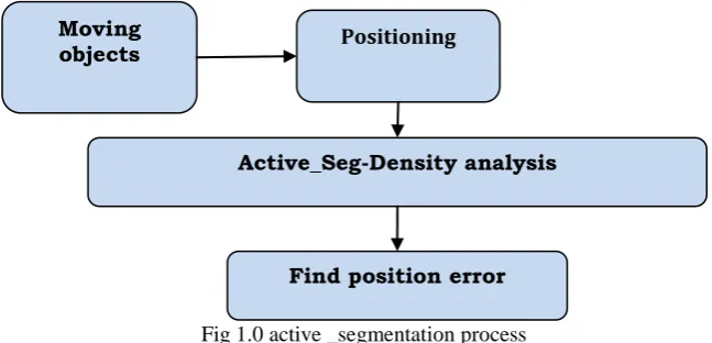
1.1 Process of Active_seg:
The Valuable information like location and uncertain event reports must be converted into raw trajectories for decision making purpose. While scrutinizing the object mobility and uncertainty, a good indication of behavior is vector and motion. Here vector is the direction of the movement and the motion is captured by trajectories which indicate the spatio-temporal characteristics of objects and encode behavior.
A key examination for uncertainty analysis on trajectories is that typical actions are repetitive while the unusual do not occur often. In this process the objects and trajectories were stored in the dataset. From the dataset the trajectory status can be monitored.
Fig 1.0 active _segmentation process
1.2 Actual position and Query Processing:
In order to reduce the noisy data there are several filtering schemes are applied in literature. Such schemes are Kalman filtering [8] for GPS data, particle filtering for RFID [9] and Map matching[10] for network constrained object locations. These approaches provide means that can infer more reliable positions where an object was actually located by eliminating the noisy and redundant data’s. The Active_seg model supports such an inferred location as an actual location of the object and helps to predict the future move based on the vector, which serves as the center point of an uncertainty range. This computes the probability distribution of an object’s position at each time by taking the current position. Specifically, this component takes a certain number of recent positions in a trajectory, and infers a Pearson distribution at a current time.
After finding the missing position of each object, the Active-seg performs the search process. Finally the approach performs the spatial query on uncertain moving object databases, the following algorithm represents the steps involved in the query processing.
Moving
objects Positioning
Active_Seg-Density analysis
ISSN(Online): 2320-9801
ISSN (Print): 2320-9798
I
nternational
J
ournal of
I
nnovative
R
esearch in
C
omputer
and
C
ommunication
E
ngineering
(An ISO 3297: 2007 Certified Organization)
Vol. 3, Issue 9, September 2015
V. RESULTS
A. Dataset:
The experiment uses the synthetic data sets for experiments. In particular, this creates synthetic data sets with reference point and service detail with the reference from the literature. The system can have n number of tuples for experiments. Our implementation takes 30000 tuples for the experiment.
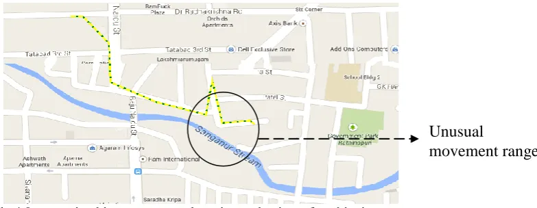
Fig: 2.0 A simple road network simulation with 35 objects
After the synthetic data set is generated, and given the number of m objects, each tuples from the synthetic uncertain database D is assigned to Si chosen uniformly. Clearly, all local objects have the same data distribution. In particular, a local site server keeps a random sample set of the underlying data set, and the sample sets are mutually disjoint. In the experiments, every local node position will be collected and stored in GPS data base.
Attribute Value
Number of objects 35 Average sampling interval 1 sec
Number of tuples 40000 and above Number of trajectories 256
1: 𝜖𝜌 ← 𝐿𝑜𝑐𝑎𝑡𝑖𝑜𝑛𝑃𝑜𝑖𝑛𝑡 𝜌
2: 𝜖𝑡← 𝑇𝑖𝑚𝑒 𝑡
3: 𝜖𝑞← 𝑞𝑢𝑒𝑟𝑦 𝑞
4: 𝜖𝜌
𝑡 𝑠𝑒𝑟𝑣𝑖𝑐𝑒𝑠 𝑠 − 𝑒𝑥𝑡𝑟𝑎𝑐𝑡 𝑠𝑒𝑟𝑣𝑖𝑐𝑒𝑠 𝑏𝑎𝑠𝑒𝑑 𝑜𝑛 𝑡ℎ𝑒 𝑠𝑝𝑎𝑡𝑖𝑜 𝑡𝑒𝑚𝑝𝑜𝑟𝑎𝑙 𝑑𝑒𝑡𝑎𝑖𝑙𝑠
5: 𝐟𝐨𝐫 each service s in SI_Tree ∈ node 𝐝𝐨 6: 𝑖𝑓 𝑇𝑖 𝑖𝑠 𝑛𝑜𝑛 𝑙𝑒𝑎𝑓 𝑖𝑛 𝑇
7: 𝐜𝐡𝐞𝐜𝐤 𝐓𝐢 ∈ 𝜖𝑡− temporal verification
9: 𝒇𝒐𝒓 𝑒𝑎𝑐ℎ 𝑛𝑜𝑑𝑒 𝑒𝑛𝑡𝑟𝑦 𝑇 ∈ 𝑇𝑖 𝒅𝒐
10: 𝒊𝒇 𝐴𝑞𝑡 ≤ 1 𝐭𝐡𝐞𝐧 − get a single record
12: 𝑒𝑙𝑠𝑒 𝑐𝑎𝑙𝑐𝑢𝑙𝑎𝑡𝑒 𝑏𝑠𝑐𝑜𝑟𝑒 ()
𝟏𝟑: do the step 4 and store the result ← 𝑇𝑟𝑎𝑗𝐻𝑎𝑠ℎ 𝐴𝑞𝑡 − get a multiple record
𝟏𝟒: Result ← 𝑇𝑟𝑎𝑗𝐻𝑎𝑠ℎ_𝑅[𝐴𝑞𝑡]
Algorithm: Active_seg- Query Processing Steps
8: 𝑠𝑝𝑎𝑡𝑖𝑎𝑙𝑄𝑢𝑒𝑟𝑦 𝑞, 𝑟𝑞 ,𝑡𝑞,𝑇𝑖 – spatial query passing based on the parameters
ISSN(Online): 2320-9801
ISSN (Print): 2320-9798
I
nternational
J
ournal of
I
nnovative
R
esearch in
C
omputer
and
C
ommunication
E
ngineering
(An ISO 3297: 2007 Certified Organization)
Vol. 3, Issue 9, September 2015
B. Results and discussion:
In this chapter, this evaluates the efficiency of the algorithms, in terms of time consumption against dimensionality d, number of sub space creation m, and indexing threshold q under two distributions of objects’ spatial locations. This also evaluates the progressiveness of the methods under different location distributions. This section evaluates the proposed route network with dynamic trajectory data framework in terms of both indexing overhead and storage performance. We applied Route Net on sample road networks, namely, dynamic route map and the final set of experiments. Active_seg not only providing uncertain movement identification, its also performs object speed calculation and speed based uncertainty detection.
Fig:3.0 Object uncertainty prediction using the movement and its speed
The above figure 3.0 represents the object mobility at every transaction. The above figure shows the uncertainty of objects based on the speed of every object and finds the uncertainty.
Fig 4.0 uncertain object movement detection at the time of positioning error
The above figure 4.0 represents the trajectory of the object 35. The uncertainty has been showed at 65th transaction. These have been tracked with the GPS signals, where the sampling error occurs if the GPS functionality interrupts. Comparative study:
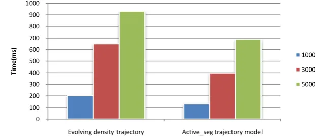
For the experiment, An Intel I3 2.2 GHz processor with 2 Gb RAM was used to measure the execution time and detection speed. Table 1.1 tabulsates the execution time for varying dataset values and Table1.2 gives the speed for varying dataset value.
Models Time 1000 3000 5000
Evolving density trajectory 200 650 930 Active_seg trajectory model 134 398 690
Table 2.0 execution comparison table
Unusual
ISSN(Online): 2320-9801
ISSN (Print): 2320-9798
I
nternational
J
ournal of
I
nnovative
R
esearch in
C
omputer
and
C
ommunication
E
ngineering
(An ISO 3297: 2007 Certified Organization)
Vol. 3, Issue 9, September 2015
The following figure 5.0 shows comparison between the existing evolving density model and Active_seg trajectory model, from the experiments the results shows the proposed system evaluates the uncertainty faster than the existing system.
Fig 5.0 execution time comparison chart VI.CONCLUSION AND FUTURE WORK
Our proposed work re-modulates the existing trajectory models to handle the uncertainty management along with the spatial query processing in trajectory database. The system proposed a new and effective approach to modeling the uncertainty of trajectories, as the existing modeling powers are insufficient to capture several important properties of trajectory data. To complement this, this proposed the Active_seg trajectory model that represents a trajectory as time-dependent Pearson distributions, and it performs the segmentation for non-uniform distributed trajectories. Then we introduced Active_seg trajectory model along with effective indexing technique. The usage of temporal SI(spatial Index) Tree, which improved the searching efficiency, which is suitable for vector based data searchingthat effectively infer time-varying densities of location data. This also developed an efficient mechanism to process spatial range queries on indexed Active_seg trajectories. This considers that this work can serve as an important basis in further studies on managing query processing delay and query suggestion on uncertain trajectory databases. In order to check the effectiveness of the proposed model can be extended with some other tree concepts in future.
REFERENCES
1. Rao, Bharat, and Louis Minakakis. "Evolution of mobile location-based services." Communications of the ACM 46.12 (2003): 61-65.
2. Li, Xu, et al. "A practical map-matching algorithm for GPS-based vehicular networks in Shanghai urban area." Wireless, Mobile and Sensor Networks, 2007.(CCWMSN07). IET Conference on. IET, 2007.
3. Lahcene, Bachioua. "On Pearson families of distributions and its applications."African Journal of Mathematics and Computer Science Research 6.5 (2013): 108-117.
4. Brown, Alison K., and Mark A. Sturza. "GPS tracking system." U.S. Patent No. 5,379,224. 3 Jan. 1995.
5. B. Kuijpers and W. Othman, “Trajectory databases: Data models, uncertainty and complete query languages,” J. Comput. Syst. Sci., vol. 76, no. 7, pp. 538–560, Nov. 2010.
6. E. Frentzos, K. Gratsias, and Y. Theodoridis, “On the effect of location uncertainty in spatial querying,” IEEE Trans. Knowl. Data Eng., vol. 21, no. 3, pp. 366–383, Mar. 2009.
7. Dai, Xiangyuan, et al. "Probabilistic spatial queries on existentially uncertain data." Advances in Spatial and Temporal Databases. Springer Berlin Heidelberg, 2005. 400-417.
8. Jain, E. Y. Chang, and Y.-F. Wang, “Adaptive stream resource management using Kalman filters,” in Proc. 2004 ACM SIGMOD Int. Conf. Manage. Data, pp. 11–22.
9. Zheng, Yu, and Xiaofang Zhou. Computing with spatial trajectories. Springer Science & Business Media, 2011.
10. S. Brakatsoulas, D. Pfoser, R. Salas, and C. Wenk, “On mapmatching vehicle tracking data,” in Proc. 31st Int. Conf. VLDB, Trondheim, Norway, 2005, pp. 853–864.
0 100 200 300 400 500 600 700 800 900 1000
Evolving density trajectory Active_seg trajectory model
Ti
me
(m
s)