A Monthly Double-Blind Peer Reviewed Refereed Open Access International e-Journal - Included in the International Serial Directories
International Journal in IT and Engineering
http://www.ijmr.net.in email id- [email protected] Page 88 Autonomous Path Planning and Navigation Method Implementation for a Interplanetary Terrain
Environment
Jagadishchandra S Naik, Dr.N.K.Misra ISRO Satellite Centre, Banglore
INDIA
Abstract:
Autonomous rovers navigating over an unknown planetary environment should traverse independently and efficiently with the knowledge of limited power, computing and motion limitations and also large time delay in the communication between ground station and space segment. The rover uses stereo images for its path planning and obstacle avoidance. Depending on the scenario and available resources, navigation has to be carried out in an autonomous way. The key agent of system is it follows both global and local path planning method to arrive at suitable path to reach the goal. In the present available setup, it gives an efficient navigation strategy to automatically traverse the rover in a planned path with less resource and energy.
Introduction:
Environment in the interplanetary space are hazardous and unstructured. The surface of such planets pose bigger challenges to our rover for autonomous navigation. Our rover must be capable of navigating in such environment without colliding with obstacles like rocks, boulders and also must avoid slipping into a pit or ravine which a cause it to tip over. There are larger areas where rover can traverse freely by avoiding obstacles. Rover should also know to avoid rocks and going towards hilly regions. Larger regions are unlikely to be explored most of the times, rovers should be intelligent to avoid such areas and avoid obstacles by rediscovering and incorporating information on the way to reach the goal. Several things are to be taken care for considering the complexity of navigation. It is not only required to consider the local motion but also to think to successfully reach the goal. For this reason we developed the challenges into local and global planning. In local planning we quietly see the hazards and obstacles using sensors attached and the rover will make decision to avoid such scenarios. In global path planning, we must see the other aspects by taking a broader view to reach the goal successfully by considering higher range of information and data. Even though the local and global planning evaluate traversability each have its own significance.
NASA has conducted experiment of on-board navigation on Mars surface using Spirit and Opportunity rovers. The purpose of the navigation system is to move the rover around the Martian surface in order to locate and approach scientifically interesting targets. To begin the process, engineers on Earth identify a goal location that they would like the rover to reach. Typically, images returned by the rover are used to select this goal. There are two main methods that can be used to reach this goal. The first and simplest is the blind drive. During a blind drive, the rover does not attempt to identify hazardous terrain and simply drives toward the goal location. The second option is autonomous navigation with hazard avoidance. In this case, the rover autonomously identifies hazards, such as large rocks, and steers around them on its way to the goal.
Related Work:
A Monthly Double-Blind Peer Reviewed Refereed Open Access International e-Journal - Included in the International Serial Directories
International Journal in IT and Engineering
http://www.ijmr.net.in email id- [email protected] Page 89 [1]. Training issues and complexity of the network is a hurdle in this. In D*algorithm we have found the complex computation and large memory requirement and it has been proposed by Carsten and others[6] and Singh and others [22 ]. It also has some advantages like dynamic updation of the path but disadvantage of not finding optimal path for smaller grids and computation time is excessively large[James-2005]. Some technologies used in Mars Rover sample return operations[ 3,14] has advantages with respect to global and local traversability. Brunner [5] used the A* algorithm for his navigation over the terrain environment for path planning and navigation, mainly micro rover navigation in autonomous environment. Singh and Others[22] uses D* algorithm for global path planning. Field D* has been used with experiments to robustly navigate over hazardous terrain. Several kind of bug algorithm has been used by different authors for navigation, path planning as well as localization. Still we have observed that there are problems exist in handling navigation w.r.t local and global path planning and identifying obstacles. We have put our efforts to bring out better methods to overcome these problems using tangent bug and A* algorithms.
System Architecture:
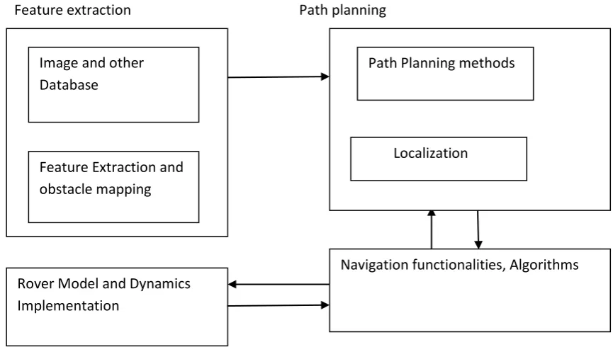
Feature extraction Path planning
Figure 1. Navigation Architecture for interplanetary mission
Feature extraction, Image processing and data analysis modules are responsible for extracting image data, conversion to DEM, analyzing the image data from rover cameras. These images are processed and filtered to identify obstacles to continue with the rover activities and science experiments. As shown in the figure 1 block architecture, the image data is passed to feature extraction and obstacle mapping where various features like rocks, boulders etc are classified to identify non navigable regions.
Rover Model and Dynamics Implementation
Image and other Database
Feature Extraction and obstacle mapping
Navigation functionalities, Algorithms Path Planning methods
A Monthly Double-Blind Peer Reviewed Refereed Open Access International e-Journal - Included in the International Serial Directories
International Journal in IT and Engineering
http://www.ijmr.net.in email id- [email protected] Page 90 Rover Model and Dynamics: The rover model and terrain surface extracted from filtering have larger significance in navigation of rover system. As far as dynamics is concerned, there are mainly 3 aspects: kinematics, dynamics and motion control.
Path Planning and Localization: This module plans the local and global path planning aspects of rover navigation. This depends on the stereo images received from Navigation Cameras and data analysis after the feature extraction process.
Navigation Module: This module simulates the rover autonomous navigation. This module decides the navigation functionalities based on the path planning and localization information received by path planning module. It makes decisions on path planning and autonomous navigation and control. There will be frequent interactions between navigation and other modules.
3.3 Terrain Classification: The terrain image classification is carried out by applying various processing methods and finally choosing the following algorithm for identifying navigable and non-navigable regions in various kinds of terrains.
The algorithm for terrain classification is as follows.
1.Input the image
2.Convert the image to a gray scale image
3.Apply edge detection Sobel operator .
4.Convert the sobel edge detected image to binary image
5. fill the image using flood fill technique.
6.Dilate the image
A Monthly Double-Blind Peer Reviewed Refereed Open Access International e-Journal - Included in the International Serial Directories
International Journal in IT and Engineering
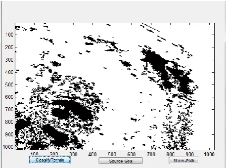
http://www.ijmr.net.in email id- [email protected] Page 91 The fig.2 shows the images obtained using the above classification method.
Fig.2 Flood filled image terrain classified image
User Interface: Our user interface can facilitate various operations which includes feature extracted terrain region identification and different navigation algorithm implementation. The current graphical user interface is designed using GUIDE of Matlab interface. We can designate the goal based on our science experiment findings.
A Monthly Double-Blind Peer Reviewed Refereed Open Access International e-Journal - Included in the International Serial Directories
International Journal in IT and Engineering
http://www.ijmr.net.in email id- [email protected] Page 92 Autonomous Path Planning:
Autonomous path planning is one of the future requirements of interplanetary missions as the ground personnel will not be able to see the three dimensional terrain features out to the more distant goal location. The path planning method described here can by itself traverse by using the image of navigation cameras, selecting the path through the terrain to the edge of effective stereo range and continuing it till goal is achieved. Those images are converted to DEM images to get the elevation and obstacle information during the traverse. In the present scenario, without autonomous planning the procedure is carried out as follows.
1. Images of Lunar terrain received form Navigation cameras (Left & Right) to enable terrain feature identification from the stereo images.
2. Generation of Digital Elevation Model on the ground to know the terrain topography. 3. Estimation of the obstacles heights & distances; terrain slope; turning angles and marking of hazards so as to obtain a suitable navigable path.
4. Finding a suitable path (within 5/10 meters) such that the Rover wheels are able to negotiate and climb the obstacles
5. Generate a similar terrain s/w model and graphically simulate the Rover mobility parameters in order to ensure successful mobility / traversal. If need be Analog model also may be
attempted.
6. Ascertain all safety parameters meets the mobility requirement (slope, sunlight, Radio
Fig.4 Navigation strategy without autonomous Navigation
communication to Lander).
7. Uplink commands to Lander craft for mobility & ascertain the same. 8. Uplink the command for Mobility Execution for the selected path.
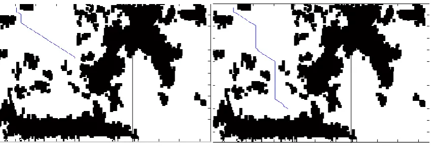
Local path planning:
A Monthly Double-Blind Peer Reviewed Refereed Open Access International e-Journal - Included in the International Serial Directories
International Journal in IT and Engineering
http://www.ijmr.net.in email id- [email protected] Page 93 tangential boundary of the obstacle. If there is no free path, stereo images are obtained to find out most promising side of the terrain for traversal and the process is repeated till the goal is reached.
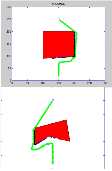
Fig 5. Tangent Bug implementation in a 2D plane with obstacles.
In the above example we can see a obstacle in red along the path towards the goal. The green line is the path chosen by the algorithm around the obstacle to reach the goal.
Localization: Localization is performed in order to correct errors that have accumulated in the rover position during traverses. It is accomplished by imaging the terrain near the rover and comparing it to a previously generated elevation map. Position estimate of the can be updated continuously to compensate for errors caused by wheel slippage or rock bumping. In NASA pathfinder mission, localization was performed manually using fixed position lander cameras, permitting operations only within the stereo envelop of the lander.
3. Global Path Planning:
A Monthly Double-Blind Peer Reviewed Refereed Open Access International e-Journal - Included in the International Serial Directories
International Journal in IT and Engineering
http://www.ijmr.net.in email id- [email protected] Page 94 process continues until the goal is reached. A* uses a best-first search and finds a least-cost path from a given initial node to one goal node (out of one or more possible goals). It uses a distance-plus-cost heuristic function (usually denoted f(x)) to determine the order in which the search visits nodes in the tree. The distance-plus-cost heuristic is a sum of two functions:
the path-cost function, which is the cost from the starting node to the current node (usually denoted g(x))
and an admissible "heuristic estimate" of the distance to the goal (usually denoted h(x)).
The h(x) part of the f(x) function must be an admissible heuristic; that is, it must not overestimate the distance to the goal. Thus, for an application like routing, h(x) might represent the straight-line distance to the goal, since that is physically the smallest possible distance between any two points or nodes.
If the heuristic h satisfies the additional condition h(x)<=d(x,y)+h(y) for every edge x, y of the graph (where d denotes the length of that edge), then h is called monotone, or consistent. In such a case, A* can be implemented more efficiently—roughly speaking, no node needs to be processed more than once - and A* is equivalent to running Dijkstra's algorithm with the reduced cost:
d'(x,y):=d(x,y)-h(x)+h(y).
For improved performance, a better waypoint vote metric is needed; something that is more accurate than Euclidean distance. A better metric can be produced by planning paths to the goal that take into account all of the obstacles in the environment.
Typically, the environment will be only partially known to the rover, and thus complete information regarding the obstacles will not be available. However, incorporating obstacle information that is available into these global plans typically provides much better estimates than Euclidean distance, and these estimates only improve in accuracy as more information is acquired during the rover’s traverse.
Global Path planning, as a navigation approach, is concerned with using geometric information about the world to formulate a path from the rover’s current location to some goal. A common approach is to use a grid to store details about reachability within the environment and then plan a path for the rover between nodes on the grid to move it from its current node to a specified goal node. Any of the standard shortest path algorithms (Floyd and Dijkstra algorithms) can be used to calculate the path to follow from the rover to a given goal by starting at the goal and attempting to reach the goal. Note that in the case of Dijkstra’s algorithm computation can be stopped when the rover’s node is reached—it is not necessary generate the complete single-source reachability analysis of the graph.
Experimental results:
A Monthly Double-Blind Peer Reviewed Refereed Open Access International e-Journal - Included in the International Serial Directories
International Journal in IT and Engineering
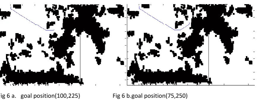
http://www.ijmr.net.in email id- [email protected] Page 95 Fig 6c.goal position(130,90) Fig 6d. goal position (250, 180)
Fig 6e.goal position(200,150) Fig 6f.goal position(250,150)
Fig 6g. goal position (260,200)
A Monthly Double-Blind Peer Reviewed Refereed Open Access International e-Journal - Included in the International Serial Directories
International Journal in IT and Engineering
http://www.ijmr.net.in email id- [email protected] Page 96 Start Position
In the Terrain Example
Goal Processing Time Path Length
(10,50) (75, 250) 2.605734e+001 2.478877e+002
(10,50) (100,225) 1.252965e+001 2.099763e+002
(10,50) (200,150) 1.484704e+001 2.431178e+002
(10,50) (250,150) 1.702784e+001 2.921678e+002
(10,50) (250,180) 2.659310e+001 3.090492e+002
(10,50) (130,190) 9.969869e+000 1.969567e+002
(10,50) (260,200) 2.466748e+001 3.333835e+002
Summary and conclusion:
This paper has provided an overview of new techniques developed to enhance the functionality of autonomous rover navigation: feature extraction with morphing, path planning and navigation using tangent bug and A* algorithm.
Autonomous rover navigation is an important technology for future missions of planetary exploration mainly Mars and other faraway planets which require a significant level of rover autonomy and the ability to handle unpredictable events. In this paper, we have described the application of algorithms developed for motion planning in difficult or constrained environments, as applied to the problem of rover navigation. We intend to continue developing the algorithms described and referenced by this paper and apply them to the problem of rover navigation for planetary exploration. Moreover future missions should accept higher goals from ground operators and should be capable to handle it in dynamic and uncertain environments.
References:
1.Youssel Bassil. Neural Network mode for path planning of robotic rover systems. International Journal of Science and Technology(IJST). E-ISSN:2224-3577, vol 2,No.2, February 2012.
2. Richard Washington1, Keith Golden, John Bresina, David E. Smith, Corin Anderson2, Trey Smith3 Autonomous Rovers For Mars Exploration, NASA Ames Research Center,
Web: ieeexplore.ieee.org
3. Richard Volpe, Eric Baumgartner, Paul Schenker, Samad Hayati, Technology Development and Testing for Enhance Mars Rover Sample Return Operations.
Web: ieeexplore.ieee.org
A Monthly Double-Blind Peer Reviewed Refereed Open Access International e-Journal - Included in the International Serial Directories
International Journal in IT and Engineering
http://www.ijmr.net.in email id- [email protected] Page 97 5. K. Landzettel, B.-M. Steinmetz, B. Brunner, K. Arbter ,M. Pollefeys, M. Vergauwen ,R. Moreas, F. Xu ,L. Steinicke, B. Fontaine A Micro-Rover Navigation and Control System for
Autonomous Planetary Exploration Web: www.cs.unc.edu/~marc/pubs/
6. Joseph Carsten, Arturo Rankin, Dave Ferguson, Anthony Stentz Global Planning on the Mars Exploration Rovers: Software integration and Surface Testing Journal of Field Robotics 26(4), 337– 357 (2009) C _ 2009 Wiley Periodicals, Inc. Published online in Wiley InterScience (www.interscience.wiley.com). • DOI: 10.1002/rob.20287
7. John Enright, Paul Furgale, Tim Barfoot, Sun Sensing for Planetary Rover Navigation 978-1-4244-2622-5/09/$25:00c 2009 IEEE IEEEAC Paper #1340, Version 2.0, Updated 9 January 2009
8. Tara Estlin, Daniel Gaines, Caroline Chouinard, Rebecca Castano, Benjamin Bornstein, Michele Judd, Issa Nesnas, and Robert Anderson, Increased Mars Rover Autonomy using AI Planning, Scheduling and Execution
Web: sensorweb.jpl.nasa.gov/public/papers/
9. Ji Liu, Yuechao Wang, Chuan Zhou, Yanfeng Geng and Yang Cong, A navigation simulation system of lunar rover
Web: ieeexplore.ieee.org
10. Richard Volpe, Tara Estlin, Sharon Laubach, Clark Olson J. Balaram Enhanced Mars Rover Navigation Techniques
Web: faculty.washington.edu/cfolson/papers
11. David P. Miller Li Tan Scott Swindell, Simplified Navigation and Traverse Planning for a Long-Range Planetary Rover
Web: http://ieeexplore.ieee.org
12. Steven B. Goldberg, Mark W. Maimone, Larry Matthies, Stereo Vision and Rover Navigation Software for Planetary Exploration Published in 2002 IEEE Aerospace Conference Proceedings, March 2002, Big Sky, Montana, USA,
http://robotics.jpl.nasa.gov/people/mwm/visnavsw/
13. Mihail Pivtoraiko1,2, Thomas M. Howard1, Issa A.D. Nesnas2, Alonzo Kelly1, Field Experiments in Rover Navigation via Model-Based Trajectory Generation and Nonholonomic Motion Planning in State Lattices
Web: citeseerx.ist.psu.edu
14. Charles R. Weisbin, Guillermo Rodriguez, Paul S. Schenker Hari Das, Samad A. Hayati, Eric T. Baumgartner, Mark Maimone, Issa A. Nesnas, Richard A. Volpe "AUTONOMOUS ROVER TECHNOLOGY FOR MARS SAMPLE RETURN"
Web: www.ri.cmu.edu
15. Larry Matthies, Erann Gat, Reid Harrison, Brian Wilcox, Richard Volpe, and Todd Litwin Mars Microrover Navigation:Performance Evaluation and Enhancement
Web: www-robotics.jpl.nasa.gov/publications/
A Monthly Double-Blind Peer Reviewed Refereed Open Access International e-Journal - Included in the International Serial Directories
International Journal in IT and Engineering
http://www.ijmr.net.in email id- [email protected] Page 98 Web: www.ri.cmu.edu/events/events/iser00/papers/
17. Simon Lacroix, Anthony Mallet and Raja Chatila, Laurent Gallo "Rover Self Localizationin Planetary Like environments Published in 5th International Symposium on Artificial Intelligence, Robotics and Automation in Space (I-SAIRAS 99), June 1999, Noordwijk, The
Netherlands
18. S L Laubah, J W Burdick "An Autonomous Sensor Based Path Planner for Planetary Microrovers. Web: www.cs.cmu.edu/~motionplanning/papers/sbp.../
19. Rowan McAllister, Thierry Peynot, Robert Fitch and Salah Sukkarieh "Motion Planning and Stochastic Control with Experimental Validation on a Planetary Rover 2012 IEEE/RSJ International Conference on Intelligent Robots and Systems October 7-12, 2012. Vilamoura, Algarve, Portugal
20. Reid Simmons, Lars Henriksen, Lonnie Chrisman and Greg Whelan "Obstacle Avoidance and Safeguarding for a Lunar Rover"
Web: www.cs.cmu.edu/~reids/papers/
21. Reid Simmons, Eric Krotkov, Lalitesh Katragadda, and Martial Hebert, " Experience with Rover Navigation for Lunar Like Terrains.
Web: repository.cmu.edu/cgi/viewcontent.cgi?article=1457&context=robotics
22. Sanjiv Singh, Reid Simmons, Trey Smith, Anthony Stentz, Vandi Verma, Alex Yahja & Kurt Schwehr "Recent Progress in Local and Global Traversability for Planetary Rovers"
Web: www.cs.cmu.edu/~reids/papers/
23. Bao Jinsong, Hu Xiaofeng, Wang Wei, Yu Dili, and Jin Ye "Lunar Rover Virtual Simulation System with Autonomous Navigation" World Academy of Science, Engineering and Technology 29 2009
24. Joseph Carsten and Arturo Rankin, Dave Ferguson and Anthony Stentz "Global Path Planning on Board the Mars Exploration Rovers", Aerospace Conference, 2007 IEEE, 3-10 March 2007
Jagadishchandra.S.Naik is a Scientist of ISRO Satellite Centre, Bangalore, India and is a research scholar of Visveswaraya Technological University(VTU), Karnataka, India. He obtained M.Tech degree in Computer Science and Engineering from Manipal Institute of Technology, Manipal, INDIA. His research areas of interests are Image processing, Virtual Reality Simulation and Human-computer Interaction. He is a life member of Indian Society of Technical Education.
A Monthly Double-Blind Peer Reviewed Refereed Open Access International e-Journal - Included in the International Serial Directories
International Journal in IT and Engineering