Grounding spatial named entities for information extraction
and question answering
Jochen L. Leidner
Gail Sinclair
Bonnie Webber
School of Informatics
University of Edinburgh
2 Buccleuch Place
Edinburgh EH8 9LW
Scotland, UK
[email protected],[email protected],[email protected]
Abstract
The task of named entity annotation of unseen text has recently been successfully automated with near-human performance.
But the full task involves more than annotation, i.e. identifying the scope of each (continuous) text span and its class (such as place name). It also involves grounding the named entity (i.e. establishing its denotation with respect to the world or a model). The latter aspect has so far been neglected.
In this paper, we show how geo-spatial named entities can be grounded using geographic co-ordinates, and how the results can be visual-ized using off-the-shelf software. We use this to compare a “textual surrogate” of a newspa-per story, with a “visual surrogate” based on geographic coordinates.
1 Introduction
The task of named entity annotation of unseen text has recently been successfully automated, achiev-ing near-human performance usachiev-ing machine learnachiev-ing (Zheng and Su, 2002). But many applications also re-quire grounding – i.e., associating each classified text span with a referent in the world or some model thereof. The current paper discusses spatial grounding of named entities that may be referentially ambiguous, using a min-imality heuristicthat is informed by external geographic knowledge sources. We then apply these ideas to the cre-ation of “visual surrogates” for news articles.
This paper is structured as follows: Section 2 discusses how spatial named entities can be grounded and how this interacts with their extraction and applications. Section 3 describes a geo-spatial resolution algorithm. Section 4 shows how maps can be automatically constructed from
named-entity tagged newswire text using resolved place names, hence introducing a new, graphical document sur-rogate. Section 5 deals with the usefulness of grounded named entities for question answering. Section 6 presents some related work, and Section 7 concludes this paper.
2 Spatial Grounding
Gazetteers are large lists of names of geographic entities, usually enriched with further information, such as their class (e.g., town, river, dam, etc.), their size, and their location (i.e. with respect to some relative or absolute coordinate system such as longitude and latitude).
Appendix A identifies some publicly available sources.
UN-LOCODE is the official gazetteer by the United Nations; it is also freely available from the UNECE Web site1 and contains more than 36 000 locations in 234
countries (UNECE, 1998). The Alexandria Gazetteer
(Smith et al., 1996; Frew et al., 1998) is another database of geographical entities, including both their coor-dinates and relationships such as: in-state-of,
in-province-of, in-county-of,
in-country-of, in-region-of, part-of
andformerly-known-as.
To date, Named Entity Recognition (NER) has only used gazetteers as evidence that a text span could be some kind of place name (LOCATION), even though their finite nature makes lists of names of limited use for classifica-tion (Mikheev et al., 1999). Here we use them for spatial grounding – relating linguistic entities of subtypeLOCA -TION(Grishman and Sundheim, 1998) to their real-world counterparts.
“World Atlases” and the gazetteers that index them are not the only resources than can be used for grounding spatial terms. In biomedicine, there are are several brain atlases of different species, using various different techniques, and focussing on both normal and disease state; as well as a digital atlas of the human body
Figure 1: Grounding an XML Ontology in Voxels: The Mouse Atlas (Baldock et al., 1999).
based on data from the Visible Human project. Such atlases and the nomenclatures that label their parts, provide an important resource for biomedical research and clinical diagnosis. For example, the Mouse Atlas
(Ringwald et al., 1994) comprises a sequence of 3D (volumetric) reconstructions of the mouse embryo in each of its 26 Theiler States of development. Indexing it is anpart-of hierarchy of anatomical terms (such as embryo.organsystem.cardiovascularsystem-.heart.atrium), called the Mouse Anatomical
Nomenclature (MAN). Each term is mapped to one or more sets of adjacent voxels2 that constitute the term’s
denotation in the embryo. Figure 1 illustrate this linkage (using 2D cross-sections) in the EMAGE database.3
Just as one might find it useful for information extrac-tion or quesextrac-tion answering to ground grographic terms found in previously unseen text, one may also find it use-ful to ground anatomical terms in previously unseen text. One example of this would be in providing support for the curation of the Gene Expression Database (GXD).4This
support could come in the form of a named entity recog-nizer for anatomical parts in text, with grounding against the Mouse Atlas, using the gazetteer-like information in the MAN.
So what is the relationship between a place name gazetteer like UN-LOCODE and the Mouse Atlas? The MAN is structured in a similar part-ofhierarchy to that of geographical locations:
USA embryo
California organ system
San Mateo County cardiovascular system
Redwood City heart
Because both gazetteers like UN-LOCODE and biomed-ical atlases like the Mouse Atlas provide spatial ground-ing for lground-inguistic terms (Figure 2), both can be used to reason about spatio-temporal settings of a discourse, for instance, to resolve referential ambiguity.
2 Pixels are points in the 2D plane x, y
; voxels are 3D
gener-alizations of pixels xyz.
3 http://genex.hgu.mrc.ac.uk/Emage/database/intro.html 4 http://genex.hgu.mrc.ac.uk/Resources/GXDQuery1/
3 Place-Name Resolution for Information
Extraction
There are many places that share the same (Berlin, Ger-many Berlin, WI, USA) or similar names (York, UK
New York, USA), usually because historically, the
founders of a new town had given it a similar or the same name as the place they emigrated from.
When ambiguous place names are used in conversa-tion or in text, it is usually clear to the hearer what spe-cific referent is intended. First, speaker and hearer usu-ally share some extra-linguistic context and implicitly ad-here to Grice’s Cooperative Principle and the “maxims” that follow, which require a speaker to provide more iden-tifying information about a location that the recipient is believed to be unfamiliar with. Secondly, linguistic con-text can provide clues: an accident report on the road between Perth and Dundee promotes an interpretation of Perth in Scotland, while an accident on the road between Perth and Freemantle promotes an interpretation of Perth in Western Australia. Computers, which are bound to se-lect referents algorithmically, can exploit linguistic con-text more easily than extra-linguistic concon-text, but even the use of linguistic context requires (as always) some subtle heuristic reasoning.
Grounding place names mentioned in a text can sup-port effective visualization – for instance, in a multimedia document surrogate that contains textual, video and map elements (e.g. in a question answering scenario), where we want to ensure that the video shows the region and the map is centered around the places mentioned.
To make use of linguistic context in resolving am-biguous place names, we apply two different minimal-ity heuristics(Gardent and Webber, 2001). The first we borrow (slightly modified) from work in automatic word sense disambiguation (Gale et al., 1992), calling it “one referent per discourse”. It assumes that a place name mentioned in a discourse refers to the same location throughout the discourse, just as a word is assumed to be used in the same one sense throughout the discourse. Neither is logically necessary, and hence both are simply
interpretational biases.
The second minimality heuristic assumes that, in cases where there is more than one place name mentioned in some span of text, the smallest region that is able to ground the whole set is the one that gives them their inter-pretation.5 This can be used to resolve referential
ambi-guity by proximity: i.e., not only is the place nameBerlin
taken to denote the same Berlin throughout a discourse unless mentioned otherwise,6but so does aPotsdam
men-5 Probably the smaller the span, the more often valid will this
heuristic be.
6 This paper is a rare exception due to its meta-linguistic
Gazetteer Named Entity Grounding Real World UN-LOCODE Novosibirsk 55°02 N; 82°55 E (Novosibirsk)
(longitude/latitude)
Mouse Atlas atrium 345, 2, 345; (part of the heart)
(set of voxels)
Figure 2: Comparison between Spatial Grounding in UN-LOCODE and the Mouse Atlas.
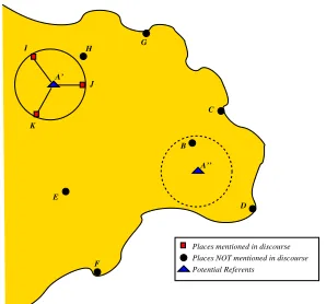
A’
Places mentioned in discourse Potential Referents Places NOT mentioned in discourse
Figure 3: A Place-Name Resolution Method.
tioned together with aBerlinuniquely select the capital of Germany as the likely referent from the set of all can-didate Berlins.7
To illustrate this “spatial minimality” heuristic, con-sider Figure 3: Assume that a mention of place Ain a text could either refer toA orA. If the text also
con-tains terms that ground unambiguously toI,J, andK, we assume the referent ofAisA rather thanA because the
former leads to a smaller spatial context.
To use this “spatial minimality” heuristic, we start by extracting all place names using a named entity recog-nizer. We then look up the “confusion set” of potential referents for each place name, e.g. forBerlin: Berlin,
FRG (German capital); Berlin, WI, USA; Berlin, NJ, USA; Berlin, CT, USA; Berlin, NH, USA; Berlin, GA, USA; Berlin, IL, USA; Berlin, NY, USA; Berlin, ND, USA; Berlin, NJ, USA . Each member of the set of
po-tential referents is associated with its spatial coordinates (longitude/latitude), using a gazetteer. We then compute the cross-product of all the confusion sets. (Each mem-ber of the cross-product contains one potential referent for each place name, along with its spatial coordinates.) For each member of the cross-product, we compute the area of the minimal polygon bounding all the potential referents, and select as the intended interpretation, the one with the smallest area.8 The resulting behaviour is 7 despite the fact that most places namedBerlin are in the
United States
8 One can approximate this, either by computing the sum of
Berlin; Potsdam Berlin, FRG (Germany)
Fairburn;Berlin Berlin, WI, USA
WestBerlin; Bishops; Dicktown Berlin, NJ, USA
Kensington;Berlin; New Britain Berlin, CT, USA
Copperville;Berlin; Gorham Berlin, NH, USA
Moultrie;Berlin Berlin, GA, USA
Berlin; Prouty Berlin, IL, USA
Berlin; Berlin Center; Cherryplain Berlin, NY, USA
Medberry;Berlin Berlin, ND, USA
Figure 4: Spatial Reference Resolution Using Spatial Minimality.
shown in Figure 4: depending on contextually mentioned other places, a different Berlin is selected.
The value of this heuristic needs to be assessed quanti-tatively against various types of text.
In resolving anatomical designators in text, we may employ a variation of the spatial minimality heuristic, based on the fact that no listing will ever be complete with respect to all the existing or new-minted synonyms for anatomical terms.
When grounding the anatomical terms in the text
In subsequent stages until birth, cytokeratin 8 continues to be expressed in embryonic taste buds distributed in punctuate patterns at regu-lar intervals along rows that are symmetrically located on both sides of themedian sulcusin the dorsal anterior developing tongue.
we find nomedian sulcuswithin the MAN, only alveo-lar sulcus,optic sulcus, pre-otic sulcus,sulcus limitans
andsulcus terminalis. We just assume that all anatomi-cal terms refer to previously recognized anatomianatomi-cal enti-ties, just as we assume that all geographic terms refer to existing geographic entities and not, for example, some new town called “Berlin” or “London” that is not yet in the gazetteer. Hencemedian sulcusis assumed to be a synonym for one of the fivesulcigiven in the MAN. At this point, we can invoke the spatial minimality heuris-tic, looking for the minimal bounding space that includes
tongueand one of the five sulci, here yielding “sulcus terminalis”. Thus the spatial minimality heuristic is here
used with other assumptions to resolve missing or previ-ously unseen terms.
4 Visualization of Geo-Spatial Aspects in
Narrative
The usefulness of visual representations to convey information is widely recognized (cf. (Larkin and Simon, 1987)). Here, we use the grounding of named entities in news stories to create a visual surrogate that represents their “spatial aboutness”.
Two news stories were selected from online newspa-pers on the same day (2003-02-21): one story (Appendix B) reports the tragic death of a baby from London in a Glasgow hospital despite flying it to a Glasgow special-ist hospital in the Royal aircraft (BBC News, 2003), and the other report (Appendix C) describes the search of the Californian police for a pregnant women from Modesto, CA, who has disappeared (The Mercury News, 2003).
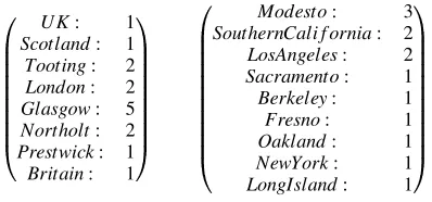
We use the term “surrogate” to refer to a partial view of a text (e.g. (Leidner, 2002)). Figure 5 shows a tex-tual surrogate in the form of all place names found in a text: an analyst who wants to get a quick overview about the locations involved in some item of news reportage, to decide its local interest or relevance, might find such a surrogate helpful, although the source would still have to be skim-read.
Story A
... Scotland ... Tooting ... London ... Glasgow ... London ... Glasgow ... Northolt ... Glasgow ... Britain ... Prestwick
... Tooting ... Glasgow ... UK ... (Glasgow) ...
Story B
Modesto ... (Southern California) ... (Modesto) ... Los Angeles ... Sacramento ... Berkeley (Marina) ... Fresno
... Oakland ... Modesto ... Los Angeles ... Southern California ... Modesto ... Southern California ... New York
... Long Island ...
Figure 5: A Textual Geo-Spatial Document Surrogate for the Stories in Appendices B and C.
We now compare this “baseline” textual surrogate to a graphical map representation that draws on the algorithm introduced before. Our simple visualisation method com-prises the following components (Figure 6): an (open-domain) news item is fed into locotagger, our sim-ple named entity tagger for place names based on UN-LOCODE.9 It recognises location names, resolves
mul-tireferential place names and looks up the coordinates:
9 For the experiment reported here, we also used data from
http://www.astro.com/cgi/aq.cgi?lang=e.
Figure 6: System Architecture.
Scott, more than a dozen news crews from <ENAMEX type="LOCATION" longitude= "-118.25" latitude="34.05">Los
Angeles</ENAMEX> to <ENAMEX type= "LOCATION" longitude="121.5" latitude="38.583333">Sacramento </ENAMEX> camped out front.
From the text we obtain a vector of types of all spatial named entities with their frequency of occurrence in the text:
SouthernCali f ornia: 2
LosAngeles: 2
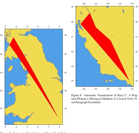
For simplicity, we drop those that correspond to regions (which are represented by sets of points) and feed the remaining list of point coordinates (corresonding to vil-lages and cities) into a map generator to generate a Mer-cator projection of the geographical area that includes all the points plus 10% of the surrounding area. For this, The Generic Map Tools (GMT)10were used, in this case via
HTTP.11
Figure 7 shows the resulting map for the story in Ap-pendix B12Figure 9 shows the map for the story in
Ap-pendix C. Clearly, such a visual surrogate is superior with respect to comprehension time than the textual surrogate presented before. It is interesting so see what happens if we leave out the final paragraph for the map creation (Figure 8): we obtain a “zoomed-in” version of the map. This turns out to be the case for many stories and is due to the convention of news reportage to close a report with linking the narrative to similar events in order to present the event in a wider context.
10 http://gmt.soest.hawaii.edu/ 11 http://stellwagen.er.usgs.gov/mapit/
12Place names that are too small to be contained in the gazetteer
-5˚ -5˚
-4˚ -4˚
-3˚ -3˚
-2˚ -2˚
-1˚ -1˚
0˚ 0˚
52˚ 52˚
53˚ 53˚
54˚ 54˚
55˚ 55˚
56˚ 56˚
Figure 7: Automatic Visualization of Story B: A Baby Flown from London to Glasgow for Medical Treatment Dies there.
-122˚ -122˚
-121˚ -121˚
-120˚ -120˚
-119˚ -119˚
-118˚ -118˚
34˚ 34˚
35˚ 35˚
36˚ 36˚
37˚ 37˚
38˚ 38˚
39˚ 39˚
Figure 8: Automatic Visualization of Story C: A Preg-nant Woman is Missing in Modeno, CA (Local View; Fi-nal Paragraph Excluded).
-120˚ -120˚
-105˚ -105˚
-90˚ -90˚
-75˚ -75˚
(Shanon, 1979) discusses how the granularity of the answers to where-questions depends on the reference points of speaker and listener (Where is the Empire State Building?– (a)In New York, (b)In the U.S.A, (c)On 34th Street and 3rd Avenue); the map generation task depends on such levels of granularity in the sense that to create a useful map, entities that belong to the same level of gran-ularity or scale should be marked (e.g. city–city rather than village–continent).
5 Question Answering
Using grounding knowledge in gazetteers also enables us to answer questions in natural language more effectively:
1. What isX?
Q:What is Kangiqsualujjuaq?
A:Kangiqsualujjuaq is a place approximately 1500
kilo-meters north of Montreal, Canada. (For some place
names, many humans cannot tell they refer to places.)
2. Where isX?
Q:Where is Cannes located?
A: [should yield a surrogate based on textual descriptions generated from the gazetteer relations:
Xis-typeY,Xpart-ofZand the coordinates, plus a map as generated above, with additional images, e.g. from satellites or picture search engines as available.]
3. WhatXisYpart of?
Q:What is ‘Bad Bergzabern’ part of?
A:Bad Bergzabern is part of the Federal Republic of
Ger-many.
Q:Is Andorra la Vella part of Spain?
A:No, Andorra la Vella belongs to Andorra.
4. How far isXfromY?
Q:How far is Cambridge from London?
A:The distance between London, England, United
King-dom and Cambridge, England, United KingKing-dom is 79 km (49 miles or 43 nautical miles).
Note here that the spatial minimality heuristic resolves Cambridge and London to places in the UK rather than, say, London, Ontario, Canada and Cambridge, Mass., USA. However the answer makes clear the precise ques-tion being adressed, so the user can follup up with a dif-ferent question if this was not what he or she intended.
Since sophisticated gazetteers are available, answering such questions should not be based on textual extraction from Internet sources, but be based on the gazetteers di-rectly, which reduces noise.
6 Related Work
Whereas a lot of work has been done in the area of spa-tial databases (Shekhar et al., 1999; Freytag et al., 2000; Paredaens, 1995; Paredaens and Kuijpers, 1998), little attention seems to have been given so far to the problem of generating maps from text or annotating maps with in-formation elicited from unstructured documents.
The work presented here perhaps most closely resembles that of (Mackinlay, 1986; Casner, 1990; Roth and Hefley, 1993) who describe systems that gen-erate multimedial representations, potentially including maps, but from a formalized knowledge source rather than unstructured text, and (Waldinger et al., 2002), who describe Geo-Logica, a system that can transform re-quests to see a place (formulated in natural language) into a three-dimensional aerial view.
7 Summary and Conclusion
Rich gazetteers can be helpful in determining unique geospatial referents and have many applications.
Starting with a description of how spatial named enti-ties can be grounded in the physical world using gazetteer knowledge in two different domains, we have described a heuristic method to resolve place names using such gazetteers.
We have then applied our method to the task of draw-ing maps from text automatically. These (geo-)graphical document surrogates give an overview aboutwherea re-ported news event takes place. We do not know of pre-vious attempts to create geographical maps automatically from unconstrained newswire text.
Many venues for further research can be conceived, for instance, a finer granularity of analysis could reveal more named entity classes (including e.g. brigdges and other artifacts) and their relative ortientation. Maps as created here could also be used to produce an animation from multiple documents (with different time-stamps) on the same topic to illustrate how the importance of places shifts over time, which could aid analysts in their timely identification of regions of crisis.
Acknowledgments. The authors are grateful to the
United Nations Economic Commission for Europe (UN-ECE) for creating UN-LOCODE, to Johanna Moore, Michael Piotrowski, IBM UK, The National e-Science Centre, Edinburgh, Richard Baldock (MRC Genetics Unit) and the Edwina Gazetteer Project for discussions and support. The three anonymous reviewers helped to improve the quality of this paper. We would also like to acknowledge the financial support for the first author of the German Academic Exchange Service (DAAD) under grant D/02/01831, of Linguit GmbH (research contract UK-2002/2), and the School of Informatics, University of Edinburgh.
References
editor, Bioinformatics Databases and Systems, pages 102–115. Kluwer Academic Press.
BBC News. 2003. Royal Mercy Flight Baby Dies. On-line (Accessed Friday 2003-02-21).
S. M. Casner. 1990.A Task-Analytic Approach to the Au-tomated Design of Information Graphics. Ph.D. thesis, University of Pittsburgh.
J. Frew, M. Freeston, N. Freitas, L. L. Hill, G. Janee, K. Lovette, R. Nideffer, T. R. Smith, and Q. Zheng. 1998. The Alexandria Digital Library architecture. InResearch and Advanced Technology for Digital Li-braries: Second European Conference (ECDL’98), Lecture Notes in Computer Science, vol. 1513, pages 19–23.
Johann C. Freytag, M. Flasza, and Michael Stillger. 2000. Implementing geospatial operations in an object-relational database system. In Statistical and Scientific Database Management, pages 209–219. W. Gale, K. Church, and D. Yarowsky. 1992. One sense
per discourse. In Proceedings of the Fourth DARPA Speech and Natural Language Workshop, pages 233– 237.
Claire Gardent and Bonnie Webber. 2001. Towards the use of automated reasoning in discourse disambigua-tion. Journal of Logic Language and Information, 10:487–509.
R. Grishman and B. Sundheim, editors. 1998. Proceed-ings of the Sixth Message Understanding Conference (MUC-7). Morgan Kaufmann.
J. Larkin and H. Simon. 1987. Why a diagram is (some-times) worth ten thousand words. Cognitive Science, 11:65–99.
Jochen L. Leidner. 2002. Discovery of Artefacts in Sci-entific Prose Using Machine Learning. M.Phil. disser-tation, University of Cambridge.
Jock D. Mackinlay. 1986. Automating the design of graphical presentations of relational information.
ACM Transactions on Graphics, 5:110–141.
Andrei Mikheev, Marc Moens, and Claire Grover. 1999. Named entity recognition without gazetteers. In Pro-ceedings of the Annual Meeting of the European Chap-ter of the Association for Computational Linguistics (EACL’99), Bergen, Norway.
Jan Paredaens and Bart Kuijpers. 1998. Data models and query languages for spatial databases. Data Knowl-edge Engineering, 25(1-2):29–53.
Jan Paredaens. 1995. Spatial databases, the final frontier. In G. Gottlob and M. Y. Vardi, editors,Proceedings of the 5th International Conference on Database Theory (ICDT), Lecture Notes in Computer Science, volume 893, pages 14–32. Springer-Verlag.
M. Ringwald, R. A. Baldock, J. Bard, M. H. Kaufman, J. T. Eppig, J. E. Richardson, J. H. Nadeau, and David-son D. 1994. A database for mouse development. Sci-ence, 265:2033–2034.
S. Roth and W. Hefley. 1993. Intelligent multimedia presentation systems: Research and principles. In Mark Maybury, editor, Intelligent Multimedia Inter-faces, pages 13–58. AAAI Press.
Benny Shanon. 1979. Where questions. In Proceed-ings of the 17th Annual Meeting of the Association for Computational Linguistics.
Shashi Shekhar, Sanjay Chawla, Siva Ravada, Andrew Fetterer, Xuan Liu, and Chang tien Lu. 1999. Spa-tial databases – Accomplishments and research needs.
Knowledge and Data Engineering, 11(1):45–55.
T. Smith, D. Andresen, L. Carver, R. Dolin, C. Fischer, J. Frew, M. Goodchild, O. Ibarra, R. Kemp, R. Kothuri, M. Larsgaard, B. Manjunath, D. Nebert, J. Simpson, A. Wells, T. Yang, and Q. Zheng. 1996. A digital library for geographically referenced materials. IEEE Computer, 29:54–60.
The Mercury News. 2003. News Crews Wait and Watch as Police Search Home of Missing Woman. Online (Accessed Friday 2003-02-21).
UNECE. 1998. LOCODE – Code for Trade and Trans-port Locations. Technical ReTrans-port and UNECE Recom-mendation 16, United Nations Economic Commission for Europe.
R. Waldinger, M. Reddy, C. Culy, J. Hobbs, and J. Dun-gan. 2002. Deductive response to geographic queries. InGIScience 2002, Boulder, CO.
GuoDong Zheng and Jian Su. 2002. Named entity tag-ging using an HMM-based chunk tagger. In Proceed-ings of the 40th Annual Meeting of the Association for Computational Linguistics, pages 209–219, Philadel-phia.
A Some Online Gazetteer Sites
Alexandria Gazetteer
http://www.alexandria.ucsb.edu/gazetteer
GIS WWW Resource List
http://www.geo.ed.ac.uk/home/giswww.html
Gazetteer of Planetary Nomenclature
http://wwwflag.wr.usgs.gov/USGSFlag/Space/nomen/nomen.html
Getty Thesaurus of Geographic Names http://shiva.pub.getty.edu/tgn browser/
U.S. Geological Survey Geographic Names IS
http://www-nmd.usgs.gov/www/gnis/
B Story
Royal Mercy Flight Baby Dies
“We would like to say thank you for all the care Khola has received,” they said in a statement.
“We wish to thank the hospital staff in Glasgow and London, the team who transported Khola, and the Queen for allowing the use of her plane. We also wish to thank everyone who prayed for our daughter.”
Khola was taken to Yorkhill Hospital An RAF Hercules had initially been scheduled to take the baby to Glasgow last month. However, it burst a tyre as it landed at Northolt.
It was then decided to fly the baby and the medical team to Glasgow in an aircraft from the Royal Squadron.
The four-engine British Aerospace 146 was the same aircraft used for the Queen’s Jubilee Tour of Britain last year.
A Royal Navy helicopter at Prestwick was mobilised and flown in bad weather to RAF Northolt where the specialist med-ical team on board was transferred to St George’s Hospital in Tooting.
The baby was stabilised in an incubator throughout the night before the transfer to Glasgow. Doctors at Yorkhill said Khola had been in need of respiratory support.
Four hospitals in the UK can provide extracorporeal mem-brane oxygenation (ECMO) for breathing difficulties, but Glas-gow was the only hospital able to accommodate Khola.
The process involves taking the baby’s blood out of the body, through an artificial lung and pumping it back in, allowing the baby’s lungs to rest.
C Story
News Crews Wait and Watch as
Police Search Home of Missing Woman
The media circus was only the latest in a long line that have sprung up around high-profile criminal cases, where the news is scant but the demand for information – even the smallest morsel – soars off the charts. “People have been interested in this type of story since pre-biblical times,” said Joe Saltzman, associate dean at the Annenberg School for Communications at the University of Southern California. “We live in a global vil-lage where everyone is our neighbor, and this is an interesting story about a man whose pregnant wife is kidnapped.”
As Modesto police completed their second day combing through the home that missing mother-to-be Laci Peterson shared with her husband, Scott, more than a dozen news crews from Los Angeles to Sacramento camped out front. Many of the reporters huddled under a tent hastily erected by one reporter as it rained and hailed.
Detective Doug Ridenour said Wednesday that investigators had completed their work, removing about 95 bags of evidence. On Tuesday, Amy Rocha, the sister of the missing woman, ac-companied detectives into the modest three-bedroom home for about two hours. But on Wednesday, investigators worked alone – completing their task about 5 p.m. They also planned to do a walk-through with Scott Peterson.
“We’ve been able to accomplish a lot,” Ridenour told re-porters at the Peterson house. “But here at this point we just don’t have the significant evidence we need to find Laci or to move in another direction.”
Ridenour would not reveal when detectives would analyze what they took away or when they would release a detailed de-scription of what they found.
He also repeated a familiar refrain: Scott Peterson is not a suspect, but he has not been ruled out as one. Suspicion has hovered over Peterson since his wife vanished Dec. 24, a day he said he was fishing at the Berkeley Marina 85 miles away.
[...]