Open Source Software: The use of open source
GIS software and its impact on organizations
Author
Mahmoud Refaat Nasr
Student ID Number: M00033608
Supervisor
Carlisle George, PhD
June 2007
Middlesex University
School of Computing Science
A thesis submitted in partial fulfilment of the requirements for the
degree of Master of Science in Business Information Technology
Creative Commons Attribution-Noncommercial-No Derivative Works 3.0 Unported License < http://creativecommons.org/licenses/by-nc-nd/3.0/ >
You are free:
• to Share — to copy, distribute and transmit the work
Under the following conditions:
• Attribution. You must attribute the work in the manner specified by the author or licensor (but not in any way that suggests that they endorse you or your use of the work).
• Noncommercial. You may not use this work for commercial purposes.
• No Derivative Works. You may not alter, transform, or build upon this work.
• For any reuse or distribution, you must make clear to others the license terms of this work. The best way to do this is with a link to this document/web page.
• Any of the above conditions can be waived if you get permission from the copyright holder.
Acknowledgements
I still remember my first orientation session in June 2005 when I had just started my Master program. Back then it all seemed like a long journey and the thesis I am presenting now seemed so distant. Now that I have finished my thesis and my master program, I can't help but look back on all the classes I attended, the wonderful people I met, and the knowledge I have gained. When I look back on all this, I have nothing but positive thoughts of the whole experience, and I think what a magnificent and enriching journey this has been.
Now I would like to say a big thank you to all those who helped inspire this research and helped it see the light. I would like to start by thanking my thesis supervisor Dr. Carlisle George whose valuable advice had always kept me on the right track. Also I would like to thank everyone who took the time and effort to participate in the surveys and provide this research with their valuable contributions. Next I would like to thank Richard Stallman whose communication with me provided me with an insight on how sincerely someone can be dedicated to his ideas. Very special thanks go to both my colleague at RITI Dina El Masry and to my friend Naafii Al Barwani for all the time and effort they provided peer reviewing this dissertation and helping me enhance it to the final form it is on now. Last but not least a really big thank you goes to my family for all the support they provided.
Abstract
Open source may be viewed by many as a revolutionary phenomenon that is capable of providing the software industry with an alternative and competitive way of doing business. Research done so far has tackled the history and business aspects of the open source phenomena, and only few have researched its technical aspects.
This thesis explores the reasons behind the poor level of adoption of open source web GIS software, and whether it is due to poor awareness about open source concepts or due to technical deficiencies in the open source tools. The research was done in 2 major phases; the first phase involved conducting surveys to measure the awareness and attitudes towards open source. The surveys examined three categories of people involved in the IT industry, namely: decision makers, software developers, and end users. The measurement of awareness was done by developing an Awareness Indicator
and a Sentiment Indicator for each category. These indicators were developed by the author during the course of the study in order to provide a measurable and descriptive indication of the results. The second phase involved performing a comparative analysis between MapServer a leading open source web GIS tool, and three of the leading proprietary web GIS software, namely: ESRI’s ArcIMS, Intergraph’s GeoMedia WebMap, and MapInfo’s MapXtreme.
The results of the research provide an insight on how different categories of people view open source, and demonstrate that lack of awareness about open source concepts and its competencies may be a major reason behind the poor adoption of open source solutions. The results of the comparative analysis also demonstrate that MapServer is technically equivalent to its commercial counter parts.
Keywords
Contents
ACKNOWLEDGEMENTS ... III ABSTRACT ... IV CONTENTS ...V LIST OF TABLES... VI LIST OF FIGURES... VI LIST OF ABBREVIATIONS ...VIICHAPTER 1: INTRODUCTION...2
1.1RESEARCH OBJECTIVE...3
1.2RESEARCH QUESTIONS...3
1.3RESEARCH FRAMEWORK...3
1.4THESIS REPORT STRUCTURE...4
CHAPTER 2: BACKGROUND AND LITERATURE REVIEW ...6
2.1INTRODUCTION...6
2.2BACKGROUND...7
2.3OVERVIEW OF THE OPEN SOURCE BUSINESS...10
2.4LITERATURE REVIEW...12
2.5CONCLUSION...22
CHAPTER 3: RESEARCH METHODOLOGY...24
3.1INTRODUCTION: ...24
3.2RESEARCH QUESTIONS: ...24
3.3PURPOSE OF THE RESEARCH: ...24
3.4RESEARCH FRAMEWORK...25
3.5INVESTIGATIONS AND DATA PROCESSING...26
CHAPTER 4: DATA COLLECTION AND ANALYSIS OF FINDINGS ...32
4.1INTRODUCTION...32
4.2INVESTIGATION1:AWARENESS OF OPEN SOURCE CONCEPTS...32
4.3INVESTIGATION 2:SELECTION CRITERIA FOR WEB BASED GIS SOFTWARE...41
4.4INVESTIGATION 3:COMPARISON BETWEEN OPEN SOURCE AND COMMERCIAL WEB GIS SOFTWARE...50
CHAPTER 5: CONCLUSION AND RECOMMENDATIONS...59
5.1INTRODUCTION...59
5.2SUMMARY OF FINDINGS...60
5.3CONCLUSION...63
5.4RECOMMENDATIONS...65
5.5SUGGESTIONS FOR FUTURE RESEARCH...66
CHAPTER 6: RESEARCH LIMITATIONS AND SELF EVALUATION ...68
6.1RESEARCH LIMITATIONS: ...68
6.2RESEARCH STRENGTHS: ...69
6.3SELF EVALUATION:...69
6.4LESSONS LEARNT: ...70
APPENDIX 1: CONDUCTED SURVEYS ...72
SURVEY 1:AWARENESS OF OPEN SOURCE CONCEPTS...72
SURVEY 2:SELECTION CRITERIA OF WEB GIS SOFTWARE...76
APPENDIX 2: SURVEY RESULTS ...85
SURVEY 1:AWARENESS OF OPEN SOURCE CONCEPTS...85
SURVEY 2:SELECTION CRITERIA OF WEB GIS SOFTWARE...90
SURVEY 2:SELECTION CRITERIA OF WEB GIS SOFTWARE (COMPILED RESULTS) ...98
APPENDIX 3: GPL LICENSE...111
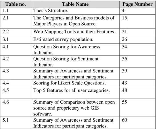
List of Tables
Table no. Table Name Page Number
1.1 Thesis Structure. 4 2.1 The Categories and Business models of
Major Players in Open Source.
15
2.2 Web Mapping Tools and their Features. 21 3.1 Estimated survey population. 26 4.1 Question Scoring for Awareness
Indicator.
34 4.2 Question Scoring for Sentiment
Indicator.
36 4.3 Summary of Awareness and Sentiment
Indicators for participant categories.
39 4.4 Scoring for Likert Scale Questions. 43 4.5 Top 5 features for all user categories. 48 4.6 Summary of Comparison between open
source and proprietary web GIS software.
55
5.1 Summary of Awareness and Sentiment Indicators for participant categories.
60
List of Figures
Figure no. Figure Name Page Number
2.1 Open Source Software development life cycle.
17
3.1 Research path. 25 4.1 Histogram of Awareness Indicator. 35
4.2 Individual Value plot of Awareness Indicator.
35
4.3 Histogram of Sentiment Indicator. 37 4.4 Individual Value plot of Sentiment
Indicator.
38
List of Abbreviations
ACM: Advanced Computer Machinery CRM: Customer Relationship Management CVS: Concurrent Versioning System ERP: Enterprise Resource planning FAO: Food and Agriculture Organization FLOSS: Free/Libre Open Source Software FOSS: Free Open Source Software FSF: Free software Foundation
GIS: Geographic Information Systems GML: Geographic Mark-up Language GPL: GNU Public License
IIS: Internet Information Services OGC: Open Geospatial Consortium OSI: Open Source Initiative
OSS: Open Source Software SDI: Spatial Data Infrastructure UMN: University of Minnesota WFP: World Food Program WFS: Web Feature Service WMS: Web Mapping Service
CHAPTER 1
CHAPTER 1: INTRODUCTION
Many believe that open source software provides benefits to businesses equivalent to those provided by commercial software products; these benefits include a very low cost of ownership, more frequent updates to the software and its functionality, and the ability to extensively customize the software to meet the needs of the business. Open source software is being supported and promoted by many organizations; such organizations include academic bodies, software developers, and other communities dedicated to open source software and open standards development such as the open source initiative (OSI) and the open geospatial consortium (OGC). These organizations are trying to increase the awareness of businesses and the public to benefits that can be obtained from open source software; they aim to promote it by engaging in activities such as conducting research and sponsoring open source communities.
Even though open source software is capable of providing various benefits to both consumers and businesses, many have kept their distance from it. Reasons for that include fear of security vulnerabilities, the thought that open source software comes with no dependable technical support, concerns regarding reliability and stability issues, and other concerns that have not been examined thoroughly before taking the decision of not implementing open source software.
When we take a look at open source GIS software we can see that it is very popular between academics, and is supported by non-profit organizations such as the FAO or the UN, which indicates that they are technically adequate for their projects. However, open source GIS software is not adopted by many companies and businesses.
This research project investigates why the use of open source GIS tools is not very common among commercial businesses. The project will present a comparative analysis between the specifications and functionality provided by some of the leading commercial GIS software, and one of the most used open source web GIS software (MapServer). The results of the above comparisons should clarify the major differences between commercial and open source GIS software, if any, as well as address the various concerns of organizations that are considering using open source GIS software.
1.1 Research Objective
• To review of current writings on open source and more specifically GIS software.
• To examine the awareness and feelings of end users, decision makers, and software developers regarding open source concepts.
• To examine which technical criteria of the software are considered when selecting a web GIS tool.
• Perform a comparative analysis between commercial GIS packages and a leading open source web GIS package.
1.2 Research Questions
Why there is a poor adoption of open source GIS tools in mainstream enterprises?
What are the concerns of developers and organizations regarding open source software?
Are there technical deficiencies in open source GIS tools that discourage developers and users from widely adopting them?
1.3 Research Framework
Three investigations will be performed in order to fulfil the purpose of the project. The first 2 investigations will be primarily conducted through online surveys. Only the third and final investigation will be performed by comparing technical features of open source software with equivalent commercial products. These investigations are outlined below.
1. The first investigation will gauge how informed people are regarding the open source concepts. The conclusions derived from this investigation will help shed light on how open source is regarded as well as answer the research questions regarding the reasons behind the majority of commercial software projects not considering open source as a competitive alternative.
2. The second investigation will examine the selection criteria of web GIS software. This will be done by studying how commercial GIS companiesmarket their products to potential customers, here the websites and online brochures of web GIS products for the 3 major GIS software providers in the world will be examined; namely ESRI, Intergraph, and MapInfo. The products that will be examined are ESRI's ArcIMS, Intergraph's GeoMedia WebMap, and MapInfo's
MapXtreme.
3. The Third and final investigation will provide a comparative analysis between one open source web GIS software (MapServer) and its commercial counterparts to see if there are technical deficiencies in open source web GIS software.
The population of the surveys will be comprised of IT professionals deal or who have dealt with web GIS in one of 3 ways; Decision makers, Users, and Developers. The surveys will be hosted and conducted online.
1.4 Thesis Report Structure
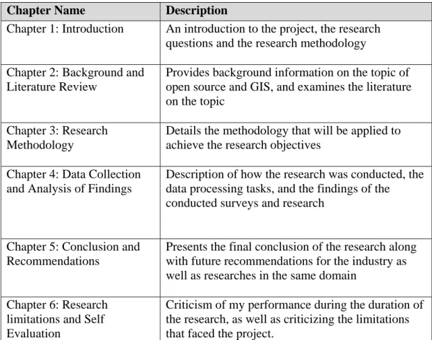
Table 1.1: Thesis Structure
Chapter Name Description
Chapter 1: Introduction An introduction to the project, the research questions and the research methodology Chapter 2: Background and
Literature Review
Provides background information on the topic of open source and GIS, and examines the literature on the topic
Chapter 3: Research Methodology
Details the methodology that will be applied to achieve the research objectives
Chapter 4: Data Collection and Analysis of Findings
Description of how the research was conducted, the data processing tasks, and the findings of the conducted surveys and research
Chapter 5: Conclusion and Recommendations
Presents the final conclusion of the research along with future recommendations for the industry as well as researches in the same domain
Chapter 6: Research limitations and Self Evaluation
Criticism of my performance during the duration of the research, as well as criticizing the limitations that faced the project.
CHAPTER 2
BACKGROUND
AND
CHAPTER 2: BACKGROUND AND LITERATURE
REVIEW
2.1 Introduction
In the late 1990’s and after loosing substantial market share to Microsoft’s Internet Explorer, Netscape decided to take a revolutionary path to try to regain some of its lost market share, and deny Microsoft a monopoly over the web browser market. They decided to take the yet to be known Open Source path. In January 23rd 1998 Netscape decided to provide both its web browser and its source code free of charge to the public domain. Strongly adopted by the developer community, Netscape’s
Open Source project came to be the “Mozilla” project. The Mozilla project attracted many developers to improve and innovate on product suite they considered to be very promising. Mozilla products were freely available to users all over the world through the project’s website. By the early 2000’s the Mozilla browsers have gained so much popularity among mainstream users that it posed a major challenge to Microsoft’s Internet Explorer. People liked Mozilla products (of which the Firefox web browser is the most famous) because it was faster and substantially more secure than Microsoft’s Internet Explorer, it was less prone to exposing their identity related information to malicious attackers, and finally because it offered new useful features to users (such as tabbed browsing, and interface customization). (Compiled from various sources) Additionally a brief look at the field of Geographical Information Systems (GIS) shows a recent inclination towards encouraging open source software development. These preferences can be seen in many of the projects being tendered both by government bodies and many of the grant projects funded by the European Union or the United Nations in developed as well as developing nations. The preference towards open source tools in the official tender documents of these projects ranges from implicit inclination towards open source and free licensing schemes, to the extent of explicitly requiring open source licensing schemes such GPL. A good example for this is the project initiated by the WFP and the FAO to create an open source GIS network called the GeoNetwork <http://www.fao.org/geonetwork>.
2.2 Background
In recent years we have been hearing people and companies speaking about alternative options to Microsoft’s operating system Windows. And we heard of different alternatives such as open source Linux, UNIX, and Mac OS, and in this operating system arena open source options such as Linux and other alternative options are slowly gaining popularity <http://marketshare.hitslink.com>. Examiners of other areas would also notice the popularity of open source software. For example
Apache, the free open source web server is used by more than 70% of internet sites <http://news.netcraft.com/archives/web_server_survey.html>. In another domain many home users, corporations, and even government bodies such as the French assembly (that will replace Microsoft Windows and Microsoft Office with Linux as the operating system of choice for all their desktops, and Open Office as their office productivity suite <http://www.pcadvisor.co.uk/news/index.cfm?newsid=7687>) are replacing proprietary closed source and costly office products (such as Microsoft
Office or IBM Lotus) with Open Office, a free and open source office productivity suite sponsored by Sun Microsystems. In the database field various alternatives are being considered to replace huge proprietary database engines such as Oracle, Sybase
or Microsoft SQL Server, individuals and businesses are looking for alternatives from the open source field such as MySQL, MaxDB, and PostgreSQL. Finally in the field of GIS, users and developers from all disciplines have been trying to replace commercial proprietary software such as ArcGIS, GeoMedia, and MapInfo, with open source tools such as GRASS, MapTools, MapBuilder, and GeoTools.
Before Netscape’s initiative in 1998 the term open source did not really exist, rather there was the term free software which was promoted by the Free Software Foundation (FSF) that was founded by Richard Stallman. The FSF was dedicated to promoting the right of users to use, study, copy, modify, and redistribute computer programs. The FSF was established in 1985 and had the objective of promoting freedom of using software as any party may wish. However, the FSF never put specific guidelines that if followed would make the software “free”, and the term “free” does not appeal to businesses in general, after all there is no such thing as a free lunch. The FSF had started by attempting to develop a free operating system, they named it the GNU operating system that later evolved to Linux. The major
contribution recognized to the FSF was the GNU Public license or the GPL, as a software license, the GPL was cleverly designed to ensure that no form of restriction can ever be placed on software derived from GPL licensed products (See Appendix 3).
In 1998 the Open Source Initiative (OSI) was founded in order to promote the standards of free software to the business community. The Open Source Initiative (OSI), which is a non-profit organization dedicated to promoting the open source values and providing software with the open source compliance certification. The first thing that needed clear definition was the term open source itself. According to the OSI, for any software to be considered open source, it has to fulfill all of the ten following terms of distribution <http://opensource.org>:
1. It must ensure free distribution of the software and must not impose any restrictions on any party to give away or sell the software.
2. The software must include the source code with it.
3. The license must allow modification and derived works; meaning that if someone modifies the original software he should be able to redistribute his new work under the same conditions.
4. The license must ensure the integrity of the author’s code by restricting the distribution of source code in modified forms only if the author will be releasing patch files with the source code. If the author will not be releasing patches for his source code, then the source code may be freely distributed.
5. The license shall have no discrimination against any persons or groups and countries for that matter.
6. It should hold no discrimination against any fields of Endeavour (such as genetic engineering or nuclear energy).
7. The rights attached to the program must apply to all entities that the program is distributed to.
8. The license must not be specific to product.
9. The license must not restrict other software. For example the license can not force all other software distributed on the same medium to comply with the open source requirements.
10.The license must be technology neutral, and should not be inclined to any individual technology or interface style.
With regards to the development life cycle of open source software is usually referred to as bazaar mode development, as opposed to conventional cathedral mode development where development of the software is limited between selected groups of developers and follows a predefined procedure such as the waterfall model (as with proprietary software development).
Eric S. Raymond (2001), co-founder of the Open Source Initiative, describes the
bazaar development mode as one where the software is exposed by its owner/creator to a large population of developers who are all welcome to add code, debug, scrutinize the existing code, and in some cases where the owner of the project looses interest in it, someone else in the community may take over the project. Projects like the world famous Linux operating system was developed in bazaar mode, where the project was made available by its owner Linus Trovalds to a world wide developer population where everyone was able to constructively contribute to the project in different ways. It is worth noting that Linux originally evolved over the years by a population of mostly part time developers.
2.3 Overview of the Open Source Business
Open source software is developed by volunteers who are usually not paid, most open source licenses make sure that no money is being made from selling the code, and most open source products offer free support for their products. So how is money made in the open source business? How do companies survive by providing free software and services? What really keeps them going? Does anyone actually make money from open source? The short answer is YES, and here are some examples. RedHat (which provides the RedHat distribution of Linux and other services related to open source software) made $105.8 million in total revenue in the last quarter of 2006 <http://www.redhat.com/about/news/prarchive/2006>. Another successful example is Sun Microsystems, which has always been a major contributor to the open source community and provides many open source products (such as the Java platform which has been released under GPL license in November 2006 < http://www.sun.com/2006-1113/feature/story.jsp>, Open office, and Net Beans) and services has made $3.189 billion in the first quarter of the fiscal year 2007 (ending October 1 2006 as reported on their website), of course it should be mentioned that Sun Microsystems has a large pool of products that include hardware and consulting services in addition to the open source technologies. Autodesk is another for-profit company that made $1.523 billion in net revenue in the fiscal year 2006 (Autodesk annual report fiscal year 2006). Autodesk recently started offering open source geospatial products such as open source Map Builder.
It has been observed that open source oriented companies make money selling support to OSS products, developing business specific add-ons for OSS tools, and selling accessory products such as books, manuals, and training material (such as O’Reily and associates)
One might think that because open source software is provided for free and along with its source code, then there is no need to attach a license to it. Therefore it may come as a surprise to learn that there are more than 30 license formats approved by the OSI. These licenses all cover the 10 terms of open source licensing but differ in other
aspects. However some licenses are more restrictive than others when it comes to enforcing open source values; for example the GNU Public License (GPL) was designed to ensure that any software resulting from an originally GPL licensed software should be GPL licensed, while research style licenses such as MIT and BSD do not introduce such enforcement, therefore making it easier for commercial software development companies to sell the open source originating code they develop.
2.4 Literature review
In an effort to investigate the previous literature addressing the research questions, various literatures have been researched ranging from the Journals and papers available on the ACM digital library, First Monday which is a peer reviewed online Journal, published papers and theses available on MIT’s Free/Open source research community, in addition to research reports conducted by independent companies such as Forrester.
Various papers from different conferences that focus on open source software have also been reviewed. There were two conferences that specially produced material that was of great value to this research. The first was the Free and Open Source Software for GeoInformatics (FOSS4G) conference that focuses on the latest research and activities of open source GIS software and their use in different business domains. The second was the ACM’s Workshop on Open Source Software Engineering (WOSSE) which deals in various topics related to the open source business and the technical aspects of developing open source software.
It has been found that most of the available literature discusses research done to address the first two research questions regarding the reasons for poor adoption of open source software and the concerns regarding open source alternatives, but only very few of the research studies examined addressed the fourth research question regarding the technical competency of open source GIS software by performing a comparative analysis between proprietary GIS software and open source GIS software.
In the following, the research questions are discussed in light of the relevant literature that resulted from previous research.
2.4.1 Motivations for adoption of open source GIS tools in mainstream businesses
One of the first reasons that come to mind when one thinks what would motivate business to adopt FOSS would be the substantial reduction in license cost of software applications. While researching literature written on the topic it was noticed that businesses involved in open source could be classified into two categories. The first category is profit oriented software development companies (mostly Independent Software Vendors) that develop software based on open source tools. The second category is companies who act as end users to software developed using open source tools.
With an aim to examine the incentives of the first category of businesses (software companies) Rossi and Bonaccorsi (2005) conducted a survey on 146 Italian firms providing open source solutions. Rossi and Bonaccorsi concluded that such firms are motivated by both extrinsic and intrinsic incentives. Extrinsic motivations are presented in reduced license costs, supplying software related services, reducing the cost of testing by relying on the open source community, and making use of the large pool of qualified open source developers, therefore reducing the cost of hiring developers in many cases. Intrinsic motivations are mostly related to conforming to the values of the open source community and code sharing. Rossi and Bonaccorsi found that only 18.5% of the companies surveyed actually conformed to the open source community standards and values while trying to make profit. The rest were either inconsistent in their behaviour towards open source standards or used open source tools in an opportunistic manner to make the most benefit they could from that model without contributing back to the open source community.
In another relevant study that aimed to examine how firms do business in the open source model, Bonaccorsi and Rossi (2003) found that many software development companies make use of the robustness provided by the open source development model in order to make financial benefits while providing the least possible contribution to the OSS community that will make them accepted as members in the community. Most of the companies that were studied made use of the open source
licensing schemes by adapting the OSS and redistributing it under a licensing scheme that is most appropriate to them and enables them to generate profit.
In a Forrester report (2005) aiming to study how firms should work with the OSS ecosystem, Michael Goulde interviewed more than 30 software development and user companies. Goulde found that almost all software development companies such as JBoss, Novell, MySQL, and RedHat generate revenue either by providing support services to open source software, developing customized add-ons to accommodate specific customer requirements, or by even by providing software under dual license, or more restrictive license strategies.
The findings of the above research prove that there is money to be made when developing software using open source tools. Yet the motivations of the companies adopting the open source model vary according to their commitment to the open source standards.
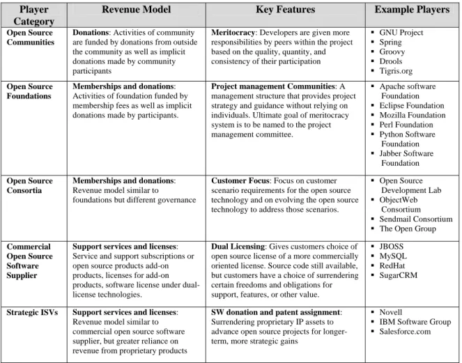
A research performed by Michael Goulde (2005) is to investigate the different business models in the open source scene are summarized in table 2.1 presented in the following page. The research examined how different companies involved in open source attempt to generate revenue. This table show that many successful, world famous companies such IBM and Novell take part in open source software development and actually benefit from it.
Table 2.1 The categories and business models of major players in Open Source Player
Category
Revenue Model Key Features Example Players
Open Source Communities
Donations: Activities of community are funded by donations from outside the community as well as implicit donations made by community participants
Meritocracy: Developers are given more responsibilities by peers within the project based on the quality, quantity, and consistency of their participation
GNU Project Spring Groovy Drools Tigris.org Open Source Foundations
Memberships and donations: Activities of foundation funded by membership fees as well as implicit donations made by participants.
Project management Communities: A management structure that provides project strategy and guidance without relying on individuals. Ultimate goal of meritocracy system is to be named to the project management committee. Apache software Foundation Eclipse Foundation Mozilla Foundation Perl Foundation Python Software Foundation Jabber Software Foundation Open Source Consortia
Memberships and donations: Revenue model similar to
foundations but different governance
Customer Focus: Focus on customer scenario requirements for the open source technology and on evolving the open source technology to address those scenarios.
Open Source Development Lab ObjectWeb
Consortium Sendmail Consortium The Open Group
Commercial Open Source Software Supplier
Support services and licenses: Service and support subscriptions or open source products add-on products, licenses for add-on products, software license under dual-license technologies.
Dual Licensing: Gives customers choice of open source license of a more commercially oriented license. Source code still available, but customers have a choice of surrendering certain freedoms and obligations for support, features, or other value.
JBOSS MySQL RedHat SugarCRM
Strategic ISVs Support services and licenses: Revenue model similar to commercial open source software supplier, but greater reliance on revenue from proprietary products
SW donation and patent assignment: Surrendering proprietary IP assets to advance open source projects for longer-term, more strategic gains
Novell
IBM Software Group Salesforce.com
Source: Goulde, 2005, p.7
Now when we come to take a look on GIS software, we will notice a trend in the previous years by GIS software vendors towards open standards; by open standards we are referring to publicly available specifications that are published, widely used within an industry, and consensus based. This trend became of great importance to GIS users and clients after suffering for years from having different proprietary software packages with proprietary data formats that limit the chances of data exchange with other entities. Therefore there was a need to go towards interoperability between data and applications. According to the OGC website, the Open Geospatial Consortium (OGC) was formed in 1994 to address the GIS community needs for better integration and interoperability among others. The open standards provided by the OGC are not tied to any specific vendor and can be used by
anybody. Yet it is worth mentioning here that the roots of the OGC originate from the free open source GRASS project that started in the 1980s (Christl 2006).
Previous efforts have been made to justify the adoption of open source GIS software in businesses and governments. For example a study conducted in 2001 by Raghavan et al to assess the feasibility of building a spatial data infrastructure (SDIi) using open source GIS tools concluded that there are tools available in the open source domain that can provide the required technology to build an SDI (Raghavan et al 2001). Yet the study documented some of the troubles that faced the implementation, such as data interoperability problems, and full compliance with industry standards. However a brief look at any of the current open source GIS software will indicate that open source GIS software has matured a lot since the findings of this study to address usability and interoperability issues.
i
A Spatial Data Infrastructure is a framework of spatial data, metadata, and tools that are
interconnected to make use of spatial data in an efficient and flexible way (wikipedia.org). SDI's offer organizations a unique chance to make use of the spatial data available in each department and reduce data redundancy. In an SDI metadata is managed centrally by it owner department.
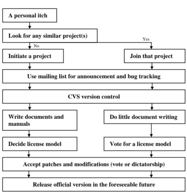
Figure 2.1: Open Source software development life cycle
Source: Al Khatib, 2006, p.29
2.4.2 Development Methodology for open source software
(Raymond 2001) Discusses how open source software is usually developed using bazaar mode where the code is openly available on the open source community for reuse, testing, criticism, and collaboration. Figure 2.1 illustrates Raymond’s view on how open source projects start and that is by addressing a developer’s “itch”. There are several portals that host open source projects and enable management, communication, versioning, bug control, and documentation sharing between members of the projects. The two most known of such portals are sourceforge.net <www.sourceforge.net> and freshmeat.net <www.freshmeat.net>.
In an attempt to investigate patterns of software development for open source projects, Stewart et al (2005) selected project samples from the online OS repository sourceforge.net <www.sourceforge.net>. The study found that most of the OS software developed in bazaar mode enabled by sourceforge.net improved in quality (measured by stability, functionality, and reduced number of bug reports) as well as in the overall number of lines of code during the lifetime of the given project. A second
A personal itch
Look for any similar project(s)
Initiate a project Join that project
Use mailing list for announcement and bug tracking
CVS version control
Write documents and manuals
Do little document writing
Decide license model Vote for a license model
Accept patches and modifications (vote or dictatorship)
Release official version in the foreseeable future
No
finding by the same research concluded that not all collaborators used sourceforge.net in the same way. Some used it to contribute to the project code and features, others used it to report bugs in a certain release, others requested support, while another group published the features they wish to see in upcoming versions or releases. Finally the study concluded that this diverse behaviour contributes to the robustness that characterizes the open source development model by enabling a larger communication channel between the users and the developers.
In another attempt to characterize the OSS development process, Capiluppi et al (2002) conducted a study on a sample of 400 projects from the open source portal freshmeat.net <www.freshmeat.net>. An interesting finding of this study was that some projects start out as bazaar mode project, and then later, when a certain business decides to incorporate these projects in their products, the businesses then form an internal closed community that requires no support from the general OS community. Such closed communities build their own support teams and develop their own patches. Capiluppi’s findings support the case that the bazaar model used in OS development is actually productive and robust. Capiluppi’s research findings also demonstrate a very good case of how businesses can use on OS software for their benefit.
Another study that aimed to study the benefit of OS software to commercial industries found that businesses benefit from the OS model due to the large number of users involved in the testing process of OS software. The benefit returned on businesses is not simply due to the quantity of testers, but due to the quality of users and testers as well. Most of the users that do the testing are drawn to the project by interest and background knowledge in the domain of the project (Gurbani et al 2005). When we contrast this to the conventional proprietary software development life cycles, we will find that the tester population for proprietary software is usually less in number, and usually less in quality because they either come from in-house testing departments, or from volunteers.
The research studies discussed show that the bazaar mode of development brings the users (who voluntarily act as testers) and the developers closer, therefore helping
produce more usable software that provides functionality that is of value to the users (because the users initially requested it).
2.4.3 Are there deficiencies in open source GIS that discourage its usage?
OS GIS software started in the 1982 with the GRASS (Geographic Resources Analysis Support System) project that was started by the US army as a tool for land planning and environmental management for the military. Of course it had not yet named open source back then. GRASS became very popular in the open source community and among academics and it is still evolving as a very successful open source GIS tool until present time. Most of the OS GIS software makes use of the already available OS infrastructure presented such as Operating Systems (different distributions of Linux), Web Servers (such as Apache), and Databases (such as MySql and PostGres). When the OGC started publishing standards for geospatial data interoperability and application standards, it has become easier for the open source community to incorporate the open standards of the OGC and even participate in the development of the standards.
The OGC’s success can be seen by the level of adoption to its standards in the OS community. For example the SF (Simple Feature access) for SQL standard which defines an interface for transparent access of geographic data, has been adopted by OS data bases such as MySql (that - according to the mysql.com website - started by implementing a subset of the specification), and PostGIS (that is fully compliant with the OGC specification) as well as by proprietary ones such as Oracle, and IBM DB2
as stated on the OGC website. The adoption of the OGC's SF SQL standard (among other OGC standards) by the Database community made it easier to store geographic data in the Database as tables holding geographic attributes rather than as flat files . The large adoption of such an openly available specification between Database providers has driven proprietary GIS software providers such as ESRI and Intergraph to move towards providing support for storage of geographic data in open formats that can be accessed by all software packages that comply with OGC standards instead of having to store their data in a proprietarily encrypted format that can only be opened by their software.
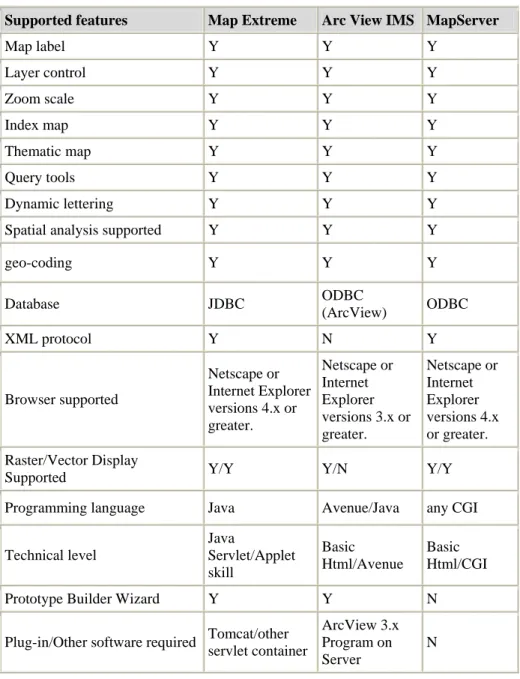
One of the few studies that were conducted to compare OS and proprietary GIS applications compared between the OS Map server tool which is a tool for publishing geographic data on the web that was developed in the University of Minnesota, and the proprietary tools MapXtreme by Map Info Corporation, and ArcIMS by Esri Inc. (Horanont et al, 2002). During the course of their research Horanont et al observed that unlike the proprietary tools considered, Map server has no prototype wizard that would help users create a web enabled mapping website without having to write code. Wizards usually provide a very handy tool for users who want to create very basic applications without having to write code; this observation raises the issue of usability in OS GIS software as compared to proprietary software.
Another observation that is very interesting in Horanont’s research was that in order to publish geographic data on the internet using proprietary software some form of data conversion and processing needed to be performed on separate desktop packages in order to prepare the data for online publishing. The data conversion process was not required for OS Map Server because it uses the OGR library that can natively access a wide variety of data formats. This finding surely provides a positive point for the interoperability features of OS tools such as Map Server. A summary of the findings of this study is presented in table 2.2.
In another study to investigate the available open source web based GIS tools, Lee and Lee (2006) concluded that the open source tools they investigated were quite mature but are unlikely to replace the commercial products especially for map creation and production. The reason mentioned for this was that commercial products have very advanced features for the map creation process that are still un-matched by similar open source tools. The author agrees with the findings of this research having personally tried a few OS desktop GIS map production tools, and found them to be challenging from a usability perspective.
The findings of the above research studies are encouraging to both software companies who wish to work with open source software, and end users (businesses) who wish to implement open source software in their business. The findings demonstrate the robustness with which open source software is developing as well as how open it is when it comes to interoperability and standards.
Table 2.2: Web Mapping tools and features
Supported features Map Extreme Arc View IMS MapServer
Map label Y Y Y Layer control Y Y Y Zoom scale Y Y Y Index map Y Y Y Thematic map Y Y Y Query tools Y Y Y Dynamic lettering Y Y Y
Spatial analysis supported Y Y Y
geo-coding Y Y Y Database JDBC ODBC (ArcView) ODBC XML protocol Y N Y Browser supported Netscape or Internet Explorer versions 4.x or greater. Netscape or Internet Explorer versions 3.x or greater. Netscape or Internet Explorer versions 4.x or greater. Raster/Vector Display
Supported Y/Y Y/N Y/Y
Programming language Java Avenue/Java any CGI
Technical level Java Servlet/Applet skill Basic Html/Avenue Basic Html/CGI
Prototype Builder Wizard Y Y N
Plug-in/Other software required Tomcat/other servlet container
ArcView 3.x Program on Server
N
Source: Horanont et al, 2002, gisdevelopment.net
Further research is yet required to investigate the technical competencies of open source GIS software, and find the reasons behind the relatively low level of adoption to open source GIS software.
2.5 Conclusion
The above researches and studies we came across in this chapter gave a brief background on the development of open source as a concept, as well as demonstrate the different business models involved in open source. They also showed us that many companies run successful businesses based on open source licensing. Additionally the researches provided us with a comparison between an open source web GIS tool and its proprietary counter parts that showed that open source products provided similar functionality to its proprietary counter parts.
The researches we came across in this chapter will help this research by helping to set the scope and direction for the questions of the surveys that will be conducted. The questions in the surveys will be refined using the conclusions and findings of these studies. Also some of the findings regarding the GIS software require updating because the comparative analysis performed by Horanont et al (2002) discussed an ESRI proprietary web programming language called Avenue that was used by ESRI before the release of the new family of products which uses conventional web development languages such as Java and .NET. The research that will be performed will shed light on the technical capabilities of the latest releases of both open source and commercial GIS software.
CHAPTER 3
CHAPTER 3: RESEARCH METHODOLOGY
3.1 Introduction:
The purpose of this chapter is to explain and clarify the research path that this thesis will take.
3.2 Research Questions:
The research will attempt to answer the following research questions:
Why there is a poor adoption of open source GIS tools in mainstream enterprises?
What are the concerns of developers and organizations regarding open source software?
Are there technical deficiencies in open source GIS tools that discourage developers and users from widely using them?
3.3 Purpose of the research:
The purpose of this project is to investigate why the use of open source GIS tools is not very common among commercial businesses. The project will present a comparison between the specifications and functionality provided by some of the leading commercial GIS software, and some of the commonly used open source GIS software. The results of the above comparisons should clarify the major differences between commercial and open source GIS software, as well as the economic and technical impacts on organizations that are considering using open source GIS software. The purpose of the research is outlined in the following points below:
• To investigate the reasons why open source GIS software are not commonly used in businesses.
• To demonstrate how requirements for developing a web based GIS application are gathered, as well as the selection criteria for a certain software tool.
• To conduct a thorough comparison between commercial and open source GIS software packages and tools.
3.4 Research Framework
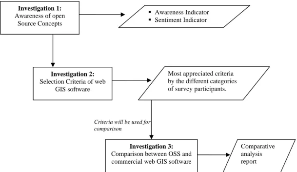
Three investigations will be performed in order to fulfil the purpose of the project. The investigations will be primarily conducted through online surveys. Only the final investigation will be performed by comparing technical features of open source software with equivalent commercial products. The details of each investigation will be explained in section 3.5. Figure 3.1 outlines the path of the investigations that will be performed during the course of this research.
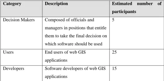
3.4.1 Population
The population of the surveys will be comprised of IT professionals who deal or who have dealt with web GIS in one of 3 ways; Decision makers, Users, and Developers. The surveys will be hosted and conducted online. Participants will be sent a link to the surveys' URL, and they will answer the survey online. The surveys will be hosted using the free online service of the website <www.createsurvey.com> which offers the possibility of hosting surveys for the duration of one month per user free of
Investigation 1:
Awareness of open Source Concepts
Investigation 2:
Selection Criteria of web GIS software
Awareness Indicator
Sentiment Indicator
Most appreciated criteria by the different categories of survey participants.
Investigation 3:
Comparison between OSS and commercial web GIS software Criteria will be used for
comparison
Comparative analysis report
charge. The website also provides basic descriptive statistics for the completed surveys. The estimated number of participants in each category will be as per the following table:
Table 3.1: Estimated Survey Populations
Category Description Estimated number of
participants Decision Makers Composed of officials and
managers in positions that entitle them to take the final decision on which software should be used
5
Users End users of web GIS applications
25
Developers Software developers of web GIS applications
15
The estimated numbers for the users and developers category are expected to increase, since participants will be encouraged to circulate the survey to their colleagues.
3.4.2 Ethical Issues:
Information about individual participants and their demographic data will not be disclosed in the research. User information that is collected using these surveys will be treated with confidentiality.
3.5 Investigations and Data Processing
All surveys involved in the investigations will include a few questions that will help provide statistics related to the demographics of the population participating in the surveys.
Such questions will relate to the experience of the individual, the size of the organization, and the role of the individual in the organization.
Investigation1: Awareness of the open source concepts
This first investigation will gauge how informed and aware people are regarding the open source concepts. The conclusions derived from this investigation will help shed light on how open source is regarded as well as answer the research questions regarding the reasons behind the majority of commercial software projects not considering open source as a competitive alternative. This investigation will include a survey (see Appendix 1), which will focus basically on how the different categories of the population (decision makers, users, and developers) regard the open source concepts.
The survey will include three sets of questions:
1. Close ended yes/ no/ don’t know questions that will test people's awareness of the standards set by the OSI for open source software. The “Don’t Know” option was added after testing the survey on a small sample of participants.
2. Close ended yes/ no/ don’t know questions that will asses how people feel about open source software in general.
3. Multiple choice and open ended questions to explore which open source software people are actually familiar with, the reasons that may motivate people to use OS software, and previous experiences with OS software.
Data Processing:
Before concluding any results from the survey, the answered surveys will be first cleaned and coded to match the scaling system mentioned below. MiniTab statistical software will be usedii for the statistical analysis of the survey. Further details on the data cleaning and coding process will be discussed in the following chapter.
1. The questions that measure people's awareness of the open source standards will be used to develop an Awareness Indicator. All answers that agree with
ii
the OSI specifications will be counted as a +ve value, while those that disagree will be counted as a –ve value. The higher the awareness Indicator, the more aware that person is of open source specifications.
2. The second group of questions that measures how people feel about open source will be used to develop a Sentiment Indicator. Answers with positive sentiment towards open source concepts will be counted as a +ve value, while those with a negative sentiment will be counted as a –ve value. The higher the sentiment Indicator, the more positive that person feels about open source software.
3. The multiple choice and open ended questions will be used to provide detailed descriptions of the participants’ attitudes towards the open source concepts.
The above mentioned indicators were developed because the author thought it would be more descriptive to develop the Awareness Indicator and the Sentiment Indicator
in the form of aggregated indicators instead of providing statistics about each individual question. Such statistics are detailed in Appendix 2.
Investigation 2: Selection criteria of open source GIS software.
This second investigation will study how commercial GIS companies market their products to potential customers. This will be done by examining the websites and online brochures of the web GIS products for the 3 major GIS software providers in the world; namely ESRI, Intergraph, and MapInfo. The products that will be examined are ESRI's ArcIMS, Intergraph's GeoMedia WebMap, and MapInfo's
MapXtreme. The brochures and websites of each product will be examined to see the main points of strength that each vendor believes differentiates them from the others. The author is assuming that each of these commercial companies has done its market research and believes that the points of strength the software that the company is highlighting is of importance to prospective customers. After examining the points of strength for each software, the author will design a survey (see Appendix 1) to examine how a population of GIS users, developers, and decision makers regard the features that are marketed by commercial software companies. The results of the
survey will also point out what features are actually considered by users when they have to select a web GIS software to implement one of their projects.
Survey 2 will be composed of a group of questions divided as follows:
1. A set of close ended yes/ no/ don’t know questions to aggregate the population’s familiarity with the topic. The “Don’t Know” option was added after testing the survey on a small sample of participants.
2. A set of scaled questions that examine the inclination of participants towards specific features in web GIS software, the answers will be scaled using a likert scale.
3. A set of multiple choices and open ended questions to explore the actual features that users in each population use, or would like to use in their applications.
Data Processing:
Before reaching any conclusions from the results of the answered surveys, the answers will be cleaned and coded in an appropriate way to enable the answers to be scored accordingly. MiniTab statistical software will be used for the statistical analysis of the survey. Further details on the data cleaning and coding process will be discussed in the following chapter.
1. The close ended questions will be used to provide a group of descriptive statistics on the participants’ general familiarity with GIS technology.
2. The likert scaled questions will be used to provide a score for each selection criteria addressed by the questions, the criteria with the highest score will be used investigation 3.
3. The multiple choice and open ended questions will be used to provide comprehensive descriptions of the participants’ GIS usage patterns.
Investigation 3: Comparative Analysis between OS and commercial web GIS software
This final investigation will use features considered in the second investigation regarding the selection criteria of web GIS software. The features will be used as points of comparison between the 3 major commercial web GIS products and one of the leading and most commonly used open source web GIS software (UMN
MapServer). The outcome of this comparative analysis will be important because it will address the concerns of decision makers and developers regarding the technical adequacy of OS web GIS software in comparison to commercial and proprietary ones.
CHAPTER 4
DATA COLLECTION
AND
CHAPTER 4: DATA COLLECTION AND ANALYSIS OF
FINDINGS
4.1 Introduction
An invitation to participate in the surveys has been sent by email to the survey population with the URL for the online surveys that was hosted on the online survey service provided by <www.createsurvey.com>. The survey population was selected from a group of IT professionals who currently deal with or have dealt with web GIS software in one of 3 ways; as Decision makers, as Users, and as Developers.
Participants were able to take part in the survey and provide their input using the internet. The website which was used to host the survey <www.createsurvey.com> provided basic descriptive statistics on the posted responses (such as the number of respondents, and the percentage for each answer), as well as provide the responses in several forms of formatted excel sheets. This was very helpful because it reduced the effort required for data entry and data preparation. This chapter explains the data collected for each of the three investigations, the data cleaning and preparation processes, and an analysis of the findings.
4.2 Investigation1: Awareness of Open Source Concepts
This survey was answered by 43 of the initially intended 45 individuals. A few users were confused about how to classify themselves in the 3 major categories of decision makers, end users, and software developers. A few users used the "other" option for their role in the organization, and provided a description of what they do. The description of what the participants do was later examined and each such participant was assigned one of the 3 initial categories; for example those who mentioned that their jobs were an IT Consultant were assigned to the decision maker category because they are involved in the decision making process of software selection. Most of the participants (39.53 %) worked in private sector, while 37 % worked in software development firms, and only 13.95 % worked for the public sector (see Appendix 2
It was interesting to find that Java was the most used open source tools used by 34 (79%) of the survey participants followed by Firefox used by 29 (67%) of the survey participants followed by Linux used by 28 (65%) of the survey participants.
Regarding the roles of the participants in the organizations, they were as follows:
• 8 (18.6%) of the participants were decision makers.
• 13 (30.4%) of the participants were end users.
• 22 (66%) of the participants were software developers.
Additionally the core questions of this first survey included two sets of close ended true or false questions. The first set of 7 questions aimed at measuring the awareness
of the survey participants about the major concepts of open source as set by the open source initiative (OSI); of course the OSI specifications in the questions have been rephrased to be easily comprehended by the general participants. The second set of 6 questions aimed at measuring the sentiment of the participants regarding open source software, and how they feel about it in general. The questions were designed to eventually develop two indicators regarding open source concepts; an Awareness Indicator, and a Sentiment Indicator. The author thought it would be more descriptive to provide theses indicators in the form of aggregated indicators instead of providing statistics for each individual question.
4.2.1 The Awareness Indicator
This Indicator represents a measure of the level of awareness the participants have about open source concepts. As mentioned earlier, the survey consisted of two groups of questions; the first group of questions was used for the calculation of the
Awareness Indicator.
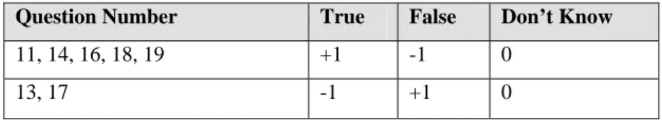
The questions concerned with the awareness of open source concepts were based on the criteria set by the OSI (Open Source Initiative) that were mentioned in the literature review (Chapter 2). The wording of the OSI criteria has been simplified in the questions to be easily understandable by the participants. The entire survey can be found in Appendix 1. The questions involved in the calculation of the Awareness Indicator were questions number: 11, 13, 14, 16, 17, 18, and 19.
These questions had one of three alternatives for an answer:
• True
• False
• Don't Know
To calculate the Awareness Indicator, the responses first had to be coded. Each response received a score depending on whether the response matches the OSI criteria in question or not. So if the response agrees with the OSI criteria related to a specific question, the response gets a +1 point. If the response contradicts the OSI criteria related to the specific question, the response gets a –1 point. All questions answered by "Don’t know" get zero points. Because as mentioned earlier the wording of each question was different from the exact wording of the OSI, and was intended to be comprehendible by the participants, not all questions with a "True" response get a +1 point, and not all questions with a "False" response get a -1 point. The coding was performed according to the following table:
Table 4.1: Question Scores for Awareness Indicator
Question Number True False Don’t Know
11, 14, 16, 18, 19 +1 -1 0
13, 17 -1 +1 0
The value of the Awareness Indicator is dependant on the number of questions involved in the evaluation which is 7 questions. Therefore the Awareness Indicator
can be ranging anywhere between +7 for participants who are fully aware about Open Source concepts, and -7 for participants who are absolutely not aware about any of the open source concepts.
The coded results were then loaded into Minitab 15 statistical software which offers various statistical analysis tools that are not available in conventional spread sheet software such as Microsoft Excel and Open Office Calc (which is the open source equivalent of Microsoft Excel). Minitab was selected over other statistical software such as SPSS due to its ease of use and the availability of online tutorials having lots of examples on how to perform specific analyses. Minitab was used to calculate the
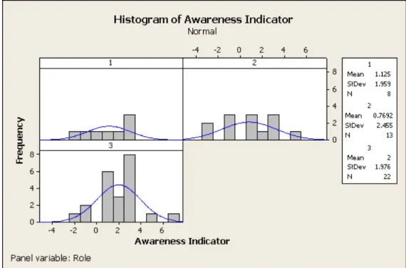
Awareness Indicator for each response. Minitab was then used to plot the histogram, individual plots, and calculating the average Awareness Indicator for each group of users. As per the graphs below it can be seen that the Software Developer category had the highest average Awareness Indicator of 2, while the End User category has the lowest average Awareness Indicator of .7692.
Figure 4.1: Histogram Distribution of Awareness Indicator
4.2.3 Sentiment Indicator
This Indicator attempts to measure how people feel about open source software by assessing whether or not people have positive opinions about open source software. The questions involved in the evaluation of this Indicator were the second group of questions in survey 1. These were a set of 6 questions that could have one of 3 possible answer; True, False, and Don’t Know. The following are an example of such opinion measuring questions:
• I believe that open source software is usually full of bugs and is unstable.
• I think that open source software is developed by amateur developers who don’t have a regular fulltime day job.
• Developers working on open source projects are not paid.
Of course agreeing with statements such as the above implies a negative sentiment about open source. Each of the 6 questions involved posed a single point of view about open source software, and the survey participants were required to state whether they think this statement was true or not. The entire survey can be found in Appendix 1. The questions involved in the calculation of the Sentiment Indicator are questions number: 8, 9, 10, 15, 20, and 21.
To calculate the Sentiment Indicator, the responses were first coded. Each response received a score according to whether the response was positive regarding open source software. So for example for the question “I believe that open source software is usually full of bugs and is unstable”; a True response will result -1 points, while a
False response will result in a +1 points, and a Don’t Know would result in 0 points. The coding was done according to the following table:
Table 4.2: Question Scores for Sentiment Indicator
Question Numbers True False Don’t Know
21 +1 -1 0
The value of the Sentiment Indicator is dependant on the number of questions involved in the evaluation which is 6 questions. Therefore the Sentiment Indicator can range anywhere between +6 for participants who feel very positive and enthusiastic about open source software, and -6 for participants who feel very negative about open source software, and will therefore be discouraged to use it.
Minitab was used to calculate the Sentiment Indicator for each response. Minitab was then used to plot the histogram, individual plots, and calculating the average
Sentiment Indicator for each group of users, and as per the graphs below it can be seen that the Software Developer category also has the highest average Sentiment Indicator of 3.136, while the Decision Maker category has the lowest average
Sentiment Indicator of 1.75.
4.2.4 Further insight on findings:
It was clear from the survey that software developers were the most aware and most likely to use open source software in their projects. This is probably due to the fact that software developers actively follow up the advances in the different technologies and are therefore more familiar with the capabilities of such technologies. Also software developers generally tend to have an exploratory nature therefore they are willing to try new technologies before judging on the feasibility of these technologies, after all Linux was developed by a community of enthusiastic software developers.
The survey contained a question regarding what may motivate the participants to use open source, the number one reason selected by participants was the freedom to install the software on an unlimited number of computers selected by 35 (81.4%) of the survey participants, followed by both the free license charge and the flexibility to modify the source code selected by 31 (72%) of the survey participants. The interesting thing about these findings is that they prove that the lack of license fees may prove to be a very strong motivation for the use of open source.
In the open ended questions that asked participants to discuss their opinion on open source software, a few participants of the "User" category mentioned that they had tried downloading and using open source software such as Linux and Open Office but they faced usability difficulties and switched back to the software they ordinarily use. This is of course typical to the cautious nature of users who usually prefer to stay with the software they are accustomed to using.
Summary of findings Investigation 1:
Table 4.3: Summary of Awareness and Sentiment Indicators for participant categories
Participant Category Awareness Indicator Sentiment Indicator
Decision makers 1.125 1.75
End Users 0.769 2.231
Software developers were found to be the most aware and most likely to use open source software in their projects.
“freedom to install the software on an unlimited number of computers” is considered the number 1 potential motive for using OS software followed by “free license charge” and “flexibility to modify the source code”
A few participants of the user category mentioned challenges they faced with OS software with regards to usability.
4.3 Investigation 2: Selection Criteria for web based GIS
software
The survey for this investigation focused on studying the criteria that are considered when selecting web GIS software to develop a web based mapping application. Before designing the questions in this survey, the major features of some of the major commercial web GIS software tools were examined. The products that were examined were ESRI's ArcIMS, Intergraph's GeoMedia WebMap, and MapInfo's MapXtreme. The brochures and websites of each product were thoroughly examined to see the main points of strength that each software vendor highlighted and believed they differentiate them from the competitors. The author is assuming that each of these commercial companies has done its market research and believes that the points of strength for the software that the company is highlighting are of importance to their customers. The following are the features that were found to be strongly stressed by the commercial software vendors:
1. The ability of the software to be integrated within the company’s information systems such as ERP and CRM.
2. The pricing scheme of the software license; whether the license is per number of users, or otherwise.
3. Whether the software has extreme hardware requirements or if it works on normally available hardware configurations.
4. How easy it is to install the software. Some software requires very complicated installation procedures while others come with installers that facilitate the process.
5. How stable the software is in terms of uptime and downtime.
6. The diversity of both attribute and spatial data sources that the softwa