“Many of the
results contained
in this report
challenge the
conventional
wisdom about
metropolitan
densities and
sprawl in the
United States.”
Center on Urban & Metropolitan Policy
■Most metropolitan areas in the United States are adding urbanized land at a much faster rate than they are adding population.Between 1982 and 1997, the amount of urbanized land in the United States increased by 47 percent, from approximately 51 mil-lion acres in 1982 to approximately 76 million acres in 1997. During this same period, the nation’s population grew by only 17 percent. Of the 281 metropoli-tan areas included in this report, only 17 (6.0 percent) became more dense. ■The West is home to some of the
densest metropolitan areas in the nation.In 1997, ten of the 15 densest metropolitan areas in the nation were located in California, Nevada, and Arizona. The South is accommodating a great deal of population growth but is urbanizing a large amount of previ-ously non-urban land to do so, while in the Northeast and Midwest, slow-growing metropolitan areas have consumed extremely large amounts of land for urbanization in order to accommodate very small quantities of population growth.
■Metropolitan areas tend to consume less land for urbanization—relative to population growth—when they are growing rapidly in population, rely heavily on public water and sewer systems, and have high levels of immigrant residents. Our analysis revealed that fast-growing regions urbanize far less land per new resident than slow-growing or declining ones. Regions are less likely to consume large amounts of land (relative to pop-ulation growth) if they have more immigrants—this finding was one of the strongest and most consistent rela-tionships we found, both at one point in time (1997) and as a change over time (1982-97).
■Metropolitan areas tend to consume more land for urbanization—again, relative to population growth—if they are already high-density metro areas and if they have fragmented local governments.Regions that were very dense in 1982 tended to urbanize more land in relation to population growth. That is, a region that was dense already had a harder time retain-ing its density durretain-ing this period. We also found that regions with frag-mented local government structures urbanized more land to accommodate population growth.
Findings
An analysis of the density trends in every metropolitan area in the United States between 1982 and 1997 reveals:
Who Sprawls Most? How Growth
Patterns Differ Across the U.S.
William Fulton, Rolf Pendall, Mai Nguyen, and Alicia Harrison1I. Introduction
T
his paper measures recent trends in how rapidly Ameri-can metropolitan areas are consuming land for urbaniza-tion in order to accommodate a changing population. It is the first national study to measure the con-sumption of land for urbanization in comparison to population growth for every metropolitan area in the United States. Our report includes both an exploration of density and density change in the U.S. and an explanation of the differences among metropolitan areas.We calculate the density of every metropolitan area in the United States between 1982 and 1997 and analyze the resulting trends. Density is defined as the population (estimated from the decennial census) divided by the urbanized land (derived from the National Resources Inventory’s national survey of land use, conducted every five years.) Thus, this is the first nationwide study that analyzes metro-politan density based on an actual measurement of urbanized land, rather than the Census Bureau’s defi-nition of “urbanized area,” which does not measure actual land use.
In general, we find that, in percent-age terms, most metropolitan areas are consuming land for urbanization much more rapidly than they are adding pop-ulation. In that sense, most U.S. metro areas are “sprawling” more rap-idly today than they have in the past. That fact is generally known. However, many of the results contained in this report challenge the conventional wis-dom about metropolitan densities and sprawl in the United States.
For example, this report finds that many of the densest metropolitan areas in the United States are located in the West—most specifically, in California, Arizona, and Nevada. Meanwhile, the older metropolitan areas of the Northeast and Midwest— while their underlying densities are
high by national standards—are sprawling far worse than their coun-terparts elsewhere in the nation.
These results challenge the conven-tional wisdom, which believes that Western cities are sprawling because they are auto-oriented, and older Northeastern and Midwestern cities are dense because they are dense in the aging core. In some sense, the conventional wisdom is correct. West-ern cities are auto oriented—that is, they do not have extremely dense old cores and they are built at densities that make it difficult to provide public transit alternatives. And in the North-east and Midwest, older core areas continue to function at very high den-sities by national standards. They contain densely developed neighbor-hoods and business districts, and they often include a very high level of pub-lic transportation riders compared to national averages.
But at the scale of the metropolitan area, the conventional wisdom is wrong—at least so far as consumption of land for urbanization is concerned. Metropolitan areas in the Northeast and Midwest are consuming land at a much greater rate than they are adding population, and so their “mar-ginal” density is extremely low. (Although they are adding population, Southern metro areas also have low marginal densities.) At the same time, the auto-oriented metropolitan areas of the West have overall metropolitan densities that are comparable to those in the Northeast and the Midwest. Furthermore, they are currently grow-ing at much higher densities than their counterparts anywhere else in the nation. In that sense, the Western metro areas—whatever else their char-acteristics may be—are using less land to accommodate population growth than metro areas in any other part of the nation.
In reviewing these results it is important to understand that this report seeks to measure sprawl in terms of consumption of land
“The most
impor-tant conclusion
this report draws
is that
metropoli-tan areas in
different parts
of the country
are growing in
different ways.”
resources only. The most important conclusion this report draws is that metropolitan areas in different parts of the country are growing in different ways. There is no single problem of “sprawl” in the United States today, and there is no single solution. Rather, the problems associated with metro-politan growth throughout the nation are characterized by regional differ-ences, and policy responses should be different as well.
II. Definitions and Methods
A. “Sprawl” as a measurement of land consumed for urbanization
“Sprawl” is an elusive term. To para-phrase the United States Supreme Court’s long-ago ruling on pornogra-phy, most people can’t define sprawl—but they know it when they see it. To some, it means a pattern of auto-oriented suburban development. To others, it means low-density residential subdivisions on the
metro-politan fringe. To many—especially in the popular press—it is simply a catch-all term that refers to any kind of suburban-style growth, whether driven by population increase or not.
Our method of defining sprawl is to characterize it simply in terms of land resources consumed to accommodate new urbanization. If land is being con-sumed at a faster rate than population growth, then a metropolitan area can be characterized as “sprawling.” If population is growing more rapidly than land is being consumed for urbanization, then a metropolitan area can be characterized as “densifying.”
This definition is not perfect by any means, simply because sprawl has so many different meanings. But it does provide a useful baseline of sprawl as it relates to the land resources of our nation and its metropolitan areas. By using this simple and comprehensive definition, information about metropoli-tan densities can provide a rudimentary understanding of sprawling patterns of
urbanization and how they affect the consumption and use of land.
B. “Density” as a measurement of land consumption and population growth
In this report, we measure the rela-tionship between population and urbanized land in terms of what we call a metropolitan area’s “density.” We define “density” as the population of a metropolitan area divided by the amount of urbanized land in that met-ropolitan area. In addition to reporting on density trends in 281 of the 282 U.S. metro areas (all but Anchorage, Alaska) between 1982 and 1997, we also report on overall trends in land urbanization and sometimes describe the trends by comparing the percent-age increase in population and the percentage increase in urbanized land (simply a different way of expressing the same data contained in our calcu-lation of “density”).
It is important to note that our measurement here is not simply a measurement of residential density (as so often occurs in the sprawl debate) but, rather, a measurement of overall density based on all the land—residen-tial, commercial, industrial, roads and highways, urban parks, and so forth— urbanized in order to accommodate population growth.
C. Using an actual measurement of land consumption to measure sprawl and density
Furthermore, this report differs from other analyses of metropolitan densi-ties by calculating densidensi-ties based on an actual measurement of urbanized land, rather than a measurement of population density.
Most similar analyses have used the U.S. Census Bureau’s definition of “urbanized area” as the denominator in calculating urban or metropolitan densities. But the Census “urbanized area” is not a measurement of actual land use or the conversion of land. Rather, it is a measurement of
popula-Map 1
tion density. Any area with a popula-tion density of 1,000 persons per square mile—that is, 1,000 persons for every 640 acres—is considered urbanized. This definition overlooks low-density suburbs, as well as areas that may accommodate urbanized land uses but not residents.
This report is based on a national survey that measures the actual use of land, rather than population density. That survey, the National Resources Inventory (NRI), is conducted by the U.S. Department of Agriculture every five years, most recently in 1997. The NRI estimates the amount of urban-ized land in every county in the United States outside Alaska. By aggregating this data, we can obtain reasonable estimates of urbanized land in 281 of the 282 metropolitan areas (all but Anchorage) as defined by the Census Bureau for the years 1982, 1987, 1992, and 1997. To calibrate the pop-ulations of metropolitan areas to the urbanized land estimates, we interpo-lated a population estimate for each metropolitan area from the decennial censuses in 1980, 1990, and 2000. We also used multiple regression to explore predictors of density, density change and urbanization.
A more detailed discussion of our methodology can be found in Appendix A.
III. Findings
A. Most metropolitan areas in the United States are adding urbanized land at a much faster rate than they are adding population.
Between 1982 and 1997, the amount of urbanized land in the United States increased by 47 percent, from approxi-mately 51 million acres in 1982 to approximately 76 million acres in 1997. During this same period, the nation’s population grew by only 17 percent.
In the five-year intervals during this period, the nation’s consumption of land for urban use went up. Between
Table 1: Fastest and Slowest Growing Metropolitan Areas, by Percent Change in Urbanized Land, 1982-1997 Fastest Urbanizing Metropolitan Areas
Rank Increase in Urbanized Land
1 Las Cruces, NM* 784.9% 2 Pueblo, CO* 763.9% 3 Naples, FL 153.3% 4 Decatur, AL 139.1% 5 Yuma, AZ 130.4% 6 Bakersfield, CA 123.6% 7 Macon-Warner Robins, GA 119.6% 8 Boise City, ID 112.4% 9 Portland, ME 108.4%
10 Fort Walton Beach, FL 106.6%
11 Nashville, TN 103.0% 12 Tuscaloosa, AL 101.7% 13 Athens, GA 101.6% 14 Huntsville, AL 99.5% 15 Tyler, TX 97.0% 16 McAllen-Edinburg-Mission, TX 97.0% 17 Raleigh-Durham, NC 93.8% 18 Tallahassee, FL 92.8% 19 Lakeland-Winter Haven, FL 92.6% 20 Orlando, FL 92.2%
Slowest Urbanizing Metropolitan Areas
Rank Increase in Urbanized Land
1 Grand Forks, ND 8.8%
2 Poughkeepsie, NY 10.0%
3 Davenport-Rock Island-Moline, IA-IL 10.5%
4 Dubuque, IA 11.3% 5 Texarkana, TX-Texarkana, AR 12.8% 6 Jamestown-Dunkirk, NY 13.0% 7 Lincoln, NE 13.0% 8 Anderson, IN 13.0% 9 Buffalo-Niagara Falls, NY 13.0% 10 Casper, WY 13.0% 11 Waterloo-Cedar Falls, IA 13.1% 12 Greeley, CO 13.9%
13 Sioux City, IA-NE 14.8%
14 Fargo-Moorhead, ND-MN 15.3% 15 Enid, OK 15.9% 16 Terre Haute, IN 16.4% 17 Great Falls, MT 17.1% 18 Battle Creek, MI 17.3% 19 La Crosse, WI 17.3% 20 Dayton-Springfield, OH 17.9%
1982 and 1987, the nation added approximately 6.1 million acres of urbanized land, an increase of 11.9 percent. Between 1987 and 1992, the nation added approximately 7.3 mil-lion acres of urbanized land, an increase of 12.6 percent. Between 1992 and 1997, the figure rose dra-matically. During this last period, the nation added approximately 11 million acres of urbanized land, an increase of 16.7 percent.
The metropolitan density of the United States declined from 5.00 per-sons per urbanized acre in 1982 to 4.22 persons per urbanized acre in 1997—a decline of 0.78 persons per acre, or 15.7 percent. This decline increased during the 1990s; from 1992 to 1997, densities declined by 0.31 persons per acre, compared to 0.22 persons per acre in 1982-1987 and 0.26 persons per acre in 1987-1992. Density in non-metropolitan counties is dropping more rapidly than that in metropolitan areas. As a conse-quence, urban land density nationwide
dropped by over 20 percent, from 4.46 to 3.55 persons per urbanized acre between 1982 and 1997.
Not surprisingly given this overall trend, the vast majority of metropoli-tan areas experienced a significant decline in metropolitan density and therefore can be described as sprawl-ing. Of the 281 metropolitan areas included in this report, only 17 (6.0 percent) either increased in density or held steady.
Fast-growing metropolitan areas are, as one might expect, adding significant amounts of urbanized land. But many metropolitan areas that are among the leaders in land urbanization are not adding population rapidly—or are adding population much more slowly than they are adding urbanized land.
For example, among the top 25 metro areas in the nation in land urbanization between 1982 and 1997 were Philadelphia, Chicago, Detroit, Cleveland, Pittsburgh, Cincinnati, and St. Louis, all of which urbanized between 100,000 and 300,000 acres
of land despite only slight increases, or even decreases, in population.
To be sure, some metro areas that added large amounts of population in a land-efficient way also urbanized large amounts of land. For example, Los Angeles urbanized more than 400,000 acres during this period, while Seattle and San Francisco urbanized more than 200,000 acres. But in these three cases, the percent-age increase in population between 1982 and 1997 was almost the same as, or greater than, the percentage increase in urbanized land.
More typically, the biggest land urbanizers in the nation were fast-growing metropolitan areas that were adding large amounts of population in a land-hungry manner. Atlanta increased its population by 60 percent but increased its urbanized land by 80 percent, adding 571,000 acres of urbanized land between 1982 and 1997. Several other metro areas that ranked among the national leaders in new acres urbanized did, indeed, increase their population significantly, but the population growth did not keep pace with the urbanization of land. Among these metro areas were Minneapolis and Charlotte (almost 300,000 acres each), Nashville and Tampa (200,000 acres each), and Raleigh and Orlando (approximately 150,000 acres each).
B. The West is home to some of the densest metropolitan areas in the nation.
The most striking single finding of this report is the dramatic difference in metropolitan growth patterns in differ-ent regions of the country. Many metro areas in the West are continuing to “densify” or hold densities steady— meaning they are urbanizing land in an efficient manner while accommo-dating large amounts of population growth. Meanwhile, the South, with some exceptions, is urbanizing land at a somewhat faster rate than it is adding population (even though it is
Map 2
adding population rapidly); the North-eastern and Midwestern metro areas are consuming large amounts of land for urbanization even though their populations are, for the most part, stagnant or growing slowly.
Of course, many older metro areas in the Northeast and Midwest still have high overall metropolitan densi-ties by national standards. However, many metro areas in the West now have overall densities approximately equal to the older metro areas in the Northeast and Midwest. On a regional basis, the West’s overall metropolitan density is approximately the same as that of the Northeast and is measura-bly higher than that of the Midwest. (For details on the density, change in population, and change in urbanized land for each census region and the metropolitan areas it contains, see Appendix B.)
The West: A growth pattern that runs counter to the national trend of decreasing densities
The West is experiencing a fundamen-tally different type of metropolitan growth than any other region of the country. Although much of the West is auto-oriented and characterized by sin-gle-family residential development, the region is consuming land far more effi-ciently than any other part of the nation. In 1997, the West as a region had the highest metropolitan density (4.85 persons per urbanized acre) of any region in the nation, exceeding even the average metropolitan density of the Northeast (4.51 persons per urbanized acre). Among the U.S. Census Bureau’s subregions, the Pacific Coast (Califor-nia, Hawaii, Oregon, and Washington) had by far the highest average density (5.76 persons per urbanized acre), sig-nificantly outstripping the Middle Atlantic States (New York, New Jersey, and Pennsylvania), which had an aver-age metropolitan density of 4.54 persons per urbanized acre.
Between 1982 and 1997, the West’s population increased by approximately
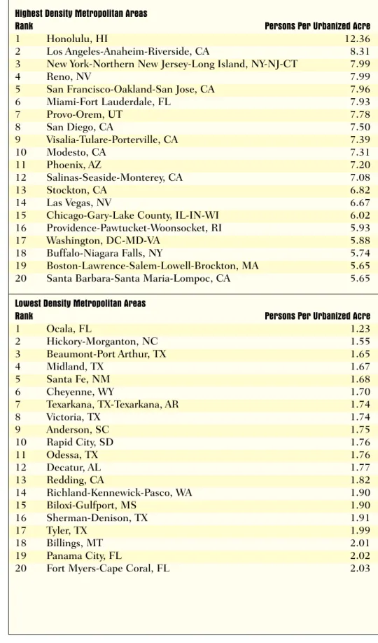
Table 2: Highest and Lowest Density Metropolitan Areas, 1997
Highest Density Metropolitan Areas
Rank Persons Per Urbanized Acre
1 Honolulu, HI 12.36
2 Los Angeles-Anaheim-Riverside, CA 8.31
3 New York-Northern New Jersey-Long Island, NY-NJ-CT 7.99
4 Reno, NV 7.99
5 San Francisco-Oakland-San Jose, CA 7.96
6 Miami-Fort Lauderdale, FL 7.93 7 Provo-Orem, UT 7.78 8 San Diego, CA 7.50 9 Visalia-Tulare-Porterville, CA 7.39 10 Modesto, CA 7.31 11 Phoenix, AZ 7.20 12 Salinas-Seaside-Monterey, CA 7.08 13 Stockton, CA 6.82 14 Las Vegas, NV 6.67
15 Chicago-Gary-Lake County, IL-IN-WI 6.02
16 Providence-Pawtucket-Woonsocket, RI 5.93
17 Washington, DC-MD-VA 5.88
18 Buffalo-Niagara Falls, NY 5.74
19 Boston-Lawrence-Salem-Lowell-Brockton, MA 5.65
20 Santa Barbara-Santa Maria-Lompoc, CA 5.65
Lowest Density Metropolitan Areas
Rank Persons Per Urbanized Acre
1 Ocala, FL 1.23 2 Hickory-Morganton, NC 1.55 3 Beaumont-Port Arthur, TX 1.65 4 Midland, TX 1.67 5 Santa Fe, NM 1.68 6 Cheyenne, WY 1.70 7 Texarkana, TX-Texarkana, AR 1.74 8 Victoria, TX 1.74 9 Anderson, SC 1.75 10 Rapid City, SD 1.76 11 Odessa, TX 1.76 12 Decatur, AL 1.77 13 Redding, CA 1.82 14 Richland-Kennewick-Pasco, WA 1.90 15 Biloxi-Gulfport, MS 1.90 16 Sherman-Denison, TX 1.91 17 Tyler, TX 1.99 18 Billings, MT 2.01 19 Panama City, FL 2.02
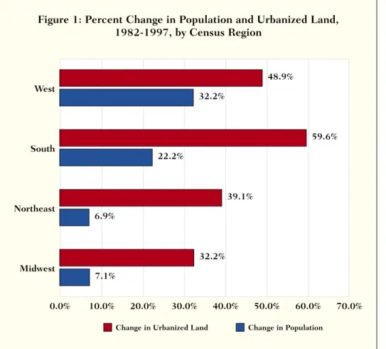
32 percent (14.4 million people), but the region increased its stock of urbanized land by only about 49 per-cent (4 million acres), for a “marginal” metropolitan density during this period of 3.59 persons per urbanized acre. This was more than triple the marginal metropolitan density of any other region. All other regions of the country—the Northeast, the Midwest, and the South—added approximately one acre of urbanized land for every resident added (See Figure 1).
We will discuss the reasons why the West has a different growth pattern in more detail below. However, it is worth noting that most metropolitan areas in the Western United States are
hemmed in by mountains and other topographical constraints and usually by federal land ownership as well. The region’s heavy reliance on public water and sewer systems is another impor-tant density-inducing factor. Still another factor may be production homebuilding practices throughout California and the desert Southwest,
which encourage master-planned developments at fairly high densities compared with new suburban develop-ment elsewhere in the nation.
Metropolitan density in the Western United States is especially notable in three geographical areas—the Califor-nia coast, CaliforCalifor-nia’s Central Valley, and the desert states of Nevada and Arizona.
California, Arizona, and Nevada were home to ten of the 15 most densely populated metropolitan areas in the United States in 1997. Honolulu (12.36 persons per urbanized acre) was
the densest metropolitan area,2the Los
Angeles Consolidated Metropolitan Statistical Area (CMSA) ranked second at 8.31 persons per acre, and the New York CMSA ranked third (7.99 persons per urbanized acre). Four California coastal metro areas ranked in the top 12: Los Angeles, San Francisco (fifth), San Diego (eighth), and Salinas-Mon-terey (12th). Three metro areas in California’s agricultural Central Valley also ranked in the top 15: Visalia
(ninth), Modesto (tenth), and Stockton (13th). All had densities of at least 6.82 persons per acre in 1997. Reno ranked fourth, Phoenix ranked 11th, and Las Vegas ranked 14th.
Examining metropolitan density increases during this period, Las Vegas led the nation with an increase in its metropolitan density of 50 percent, thus rising in the overall density rank-ings from 114th in 1982 to 14th in 1997. Phoenix ranked third in density gains during this period. Also during this period, metropolitan Los Angeles closed the gap with metropolitan New York considerably. In 1982, metropoli-tan Los Angeles had 8.09 persons per urbanized acre—roughly 17 percent behind New York ( 9.44 persons per acre). However, during the next 15 years, metro New York’s density dropped by almost 1.5 persons per acre (a 14.7 percent drop overall), while metro L.A.’s rose slightly. Thus, by 1997, Los Angeles was denser than New York; their densities were 8.31 and 7.99, respectively.
Other metropolitan areas in the West—especially smaller ones— sprawled more noticeably during this period. Portland and Seattle had met-ropolitan densities of 5.10 persons per urbanized acre in 1997—high by national standards, but much lower than the Southwestern cities. Metro-politan density in both metro areas dropped by approximately 11 percent during the 15-year period—which is not much of a slide by national stan-dards but more than that of the Southwestern cities.
Smaller metro areas experienced considerable sprawl during the 1982–97 period, especially Boise, Idaho; Las Cruces, N.M.; Pueblo,
Colorado; and Yuma, Arizona.3
The South: Growing in population but sprawling as well
With a few exceptions, metropolitan areas in the South are consuming large amounts of land in order to accommodate large amounts of Map 3
population growth.
As a region, the South added 17.2 million people between 1982 and 1997—20 percent more than did the West, which added 14.4 million peo-ple. But the South consumed three times as much land to accommodate this population growth—increasing its stock of urbanized land by almost 12.5 million acres, compared to an increase of only 4.1 million acres in the West. In density terms, the West averaged 3.59 new residents for every new urbanized acre, compared to only 1.37 for the South.
For example, Nashville increased its metropolitan population by 289,000 people between 1982 and 1997—an increase of approximately 33 percent. But the amount of urbanized land in Nashville increased by 216,000 acres—a rise of more than 100 per-cent. In other words, Nashville urbanized an average of almost one acre of land to accommodate each additional resident of the metropolitan region. Many other Southern metro-politan areas experienced a similar ratio of population growth to increase in urbanized land, including
Huntsville, Alabama; Fort Walton Beach, Florida; Athens, Georgia; Columbia, South Carolina; and Asheville, North Carolina—all of which ranked in the top 25 nationally in the percentage increase in urban-ized land.
Atlanta, which has become synony-mous with sprawl in the last few years, had the largest absolute (but not per-centage) increase in urbanized land of any metropolitan area in the nation— approximately 571,000 acres. This figure was far ahead of New York, Dal-las, Los Angeles, and Houston, which ranked second through fifth nationally, again, in terms of absolute rather than percentage gains. High as this figure is in raw numbers, however, it does not look extremely sprawling compared with other Southern metro areas. Atlanta added approximately 1.3 mil-lion persons during this period,
Table 3: Greatest Percentage Gains and Losses in Metropolitan Area Density, 1982-1997 Metropolitan Areas with Greatest Density Gain
Rank Density Change
1 Las Vegas, NV 50.8%
2 Fort Pierce, FL 29.9%
3 Phoenix, AZ 21.9%
4 Greeley, CO 16.1%
5 Austin, TX 16.0%
6 Fort Myers-Cape Coral, FL 15.2%
7 West Palm Beach-Boca Raton-Delray Beach, FL 10.4%
8 Ocala, FL 8.1% 9 Lincoln, NE 7.2% 10 Fort Collins-Loveland, CO 5.5% 11 Fargo-Moorhead, ND-MN 3.9% 12 Sarasota, FL 3.4% 13 Stockton, CA 2.8% 14 Los Angeles-Anaheim-Riverside, CA 2.8% 15 Medford, OR 2.0% 16 Poughkeepsie, NY 1.0% 17 Reno, NV 0.0% 18 Visalia-Tulare-Porterville, CA -0.1% 19 Fresno, CA -0.2% 20 Salinas-Seaside-Monterey, CA -1.3%
Metropolitan Areas with Greatest Density Loss
Rank Density Change
1 Pueblo, CO* -87.44% 2 Las Cruces, NM* -82.20% 3 Decatur, AL -51.10% 4 Macon-Warner Robins, GA -48.64% 5 Anniston, AL -45.91% 6 Portland, ME -43.65% 7 Tuscaloosa, AL -42.12% 8 Charleston, WV -41.22% 9 Longview-Marshall, TX -41.05% 10 Johnstown, PA -40.81% 11 Muncie, IN -38.22% 12 Tyler, TX -38.01% 13 Sharon, PA -37.87% 14 Steubenville-Weirton, OH-WV -37.35% 15 Asheville, NC -35.83% 16 Wheeling, WV-OH -35.58% 17 Utica-Rome, NY -35.51% 18 Pittsburgh-Beaver Valley, PA -35.50% 19 Bakersfield, CA -35.43% 20 Huntsville, AL -34.39%
meaning the region urbanized approxi-mately one acre of land for every two new residents.
There were some exceptions to the pattern of Southern sprawl, especially in Texas and Florida. In Texas, the large metropolitan areas of Houston, Dallas, Austin, and San Antonio all are fairly dense by Southern standards (three persons or more per urbanized acre) and their densities did not decline much between 1982 and 1997. Austin was one of 17 metro areas that grew in density between 1982 and 1997, and the other three declined no more than 8.5 percent, ranking them among the national leaders in “holding” their densities. However, smaller Texas metropolitan areas such as Beaumont, Midland, Tyler, and Odessa rank among the least dense metropolitan areas in the nation, and most of them declined noticeably during the 1982–1997 period.
Florida metro areas varied dramati-cally in both their density and their density change. Metropolitan Miami has always been densely developed. During the 1982-1997 period it retained its density and in 1997 ranked sixth nationally with a density of 7.93 persons per urbanized acre. Fast-growing Orlando began with a lower density but used land efficiently by Southern standards, increasing its population by 560,000 while urbaniz-ing approximately 150,000 acres of land. Tampa-St. Petersburg had simi-lar figures.
Many smaller metropolitan areas in Florida also experienced density increases during this period. However, these metro areas were extremely sprawling to begin with. For example, Ocala, Florida, increased in density between 1982 and 1997. However, at the end of this 15-year period, it still ranked dead last among all 281 U.S.
metro areas in metropolitan density, with 1.23 persons per urbanized acre. The Northeast and the Midwest: Enormous land consumption, little population growth
Unlike the West and the South, the Northeast and the Midwest are not increasing their populations very much. However, they are urbanizing large amounts of land anyway. In that sense, these two “Rust Belt” regions can be viewed as being the nation’s biggest sprawl problems.
Between 1982 and 1997, the Northeast saw its overall population density drop by 23 percent (to 4.51 persons per urbanized acre) while the Midwest saw its overall population density drop by 19 percent (to 3.39 persons per acre). These regions used land extremely inefficiently. Popula-tion in the Northeast increased by 3.4 million people, but its total amount of urbanized land grew by 3.2 million acres—meaning that the region urbanized an average of one acre to accommodate each new resi-dent. In the Midwest, the figures were slightly worse: The region increased its population by 4.1 million people but increased its urbanized land by 4.5 million acres, for a “marginal metro-politan density” of 0.91 persons per acre.
Most metropolitan areas in the Northeast and Midwest added few people but consumed a considerable amount of land. Of the 179 metropoli-tan areas that experienced slow or no population growth between 1982 and 1997, 117 of them (65 percent) were located in Northeastern and Midwest-ern states. Boston, for example, grew in population by 6.7 percent but increased its stock of urbanized land by almost half (46.9 percent).
Fifty-six metro areas lost population from 1982 to 1997. Virtually all of them were in the Northeast and Mid-west. Every single one of these metro areas increased their total amount of urban land by at least 8 percent. 10.0% 0.0% 20.0% 30.0% 40.0% 50.0% 60.0% 70.0% West 48.9% 32.2% South 59.6% 22.2% Northeast 39.1% 6.9% Midwest 32.2% 7.1%
Change in Urbanized Land Change in Population
Figure 1: Percent Change in Population and Urbanized Land, 1982-1997, by Census Region
Half of the metropolitan areas that lost population increased their total amount of urban land by at least 25 percent. Many of these metro areas were in the “Rust Belt” of the North-east and Midwest. Pittsburgh, for example, dropped 8 percent in popula-tion but increased its urbanized land by 42 percent. Steubenville, Ohio, and Wheeling, West Virginia (both of which are near Pittsburgh) dropped in population by approximately 15 per-cent but saw their urbanized land increase by approximately one-third.
Even those few metropolitan areas in the Northeast and Midwest that did increase their population significantly also sprawled measurably. For exam-ple, Minneapolis-St. Paul increased in population by 550,000 persons, or 25 percent. However, it increased its stock of urbanized land by 270,000 acres, or approximately 61 percent. As a result of this “marginal” density of two persons per acre, the region’s overall metropolitan density dropped 22 percent, from 4.96 to 3.85 persons per urbanized acre. Another thriving Midwestern city, Columbus, Ohio, recorded somewhat similar statistics, though it did not grow as much. And Portland, Maine, had high population growth by Northeastern standards (17 percent), yet increased its urban-ized land by 108 percent—more than five times the percentage increase in population.
However, even with these dramatic declines in density, the older industrial metropolises remained among the densest in the nation even in 1997. New York recorded a density of 7.99, Buffalo 5.74, and Philadelphia 5.03. C. Metropolitan areas tend to consume less land for urbaniza-tion—relative to population growth—when they are growing rapidly in population, rely heavily on public water and sewer systems, and have high levels of immigrant residents. Metropolitan areas tend to consume more land for
urbaniza-tion—again relative to population growth—if they are already high-density metro areas and if they have fragmented local governments. Going beyond our description of met-ropolitan areas, we also explored how density and urbanization relate to fac-tors other than population growth, such as metropolitan area population, demography, economics, physical geography, infrastructure, planning environment, and fiscal structure. As we showed in the previous section, metropolitan areas that are rapidly gaining population have had a wide variety of increases in urbanized land, and metropolitan areas that had large increases in urbanized land did not necessarily do so because they were accommodating large population increases—some were not gaining new residents at all. Other factors, then, must be responsible for the variation we observe among metropolitan areas.
We began with a long list of charac-teristics we thought might be
associated consistently with density, based on literature reviews and our own experience (see Appendix C). Many of these variables are correlated with one another, however, and the large number of variables that would be insignificant in any analysis would create “noise” if they remained in the statistical analysis. We therefore used a technique called backward stepwise regression, which begins by including all the variables in an equation and sequentially removes one variable at a time based on its failure to explain dif-ferences in metropolitan density, re-running the analysis at each step. In all cases, these relationships are true “all else being equal”; for exam-ple, if we hold growth rates,
immigration, Hispanic shares, and other variables constant, more popu-lous metropolitan areas tend to be denser.
Although we found that many of the same variables associated with both density differences in 1997 and density change between 1982 and 1997, other
variables had effects that differed between the two. We also analyzed per-cent change in urbanized land, and found mostly consistent results.
Eleven variables associated signifi-cantly4with the regional density variable (see Table 4). Twelve variables explain density change between 1982 and 1997 (see Table 5); and nine asso-ciate with variation in percent change in urbanized land (see Table 6). The factors that we discuss cannot be said to “cause” density differences; many of them may in fact be consequences of high or low density. (For regression coefficients, significance levels, and case studies that explain how these variables play out in five metropolitan areas, see www.brookings.edu/urban/
fulton-pendall.)
Population and historic conditions have strong influences on density, sprawl, and urbanization.
Faster-growing metropolitan areas tend to be less dense, holding population size constant. They also urbanize more land than slow-growing metropolitan areas. Yet, at the same time, they tend to sprawl less.
This finding gets at the heart of two different ways to think about sprawl: is it based on current density, or a change in urbanized area compared to population? When we hold constant the population size, metropolitan areas that grew fast between 1982 and 1997 tended to have lower density in 1997. And in our analysis of differences in percent change in urban land, we found that—all else being equal—fast-growth metropolitan areas urbanized more land than did slow-growth regions. Additionally, high-density met-ros tended to urbanize more land than low-density metros between 1982 and 1987.
Does this mean that population growth caused these metropolitan areas to sprawl? No. In fact, fast-grow-ing metro areas lost less density between 1982 and 1997 than did slow-growing ones. Metropolitan areas
that were dense in 1982 were likely, all else being equal, to sprawl more between 1982 and 1997 than those that started out with lower densities. But in the West, fast growth—which discourages sprawl—often counter-acted the sprawl-inducing effects of high initial density. In the Northeast, by contrast, most high-density metro-politan areas grew much more slowly than those in the West. Since both high density and slow growth induce sprawl, the Northeast sprawled more than the West.
Together, the analyses of density change and urbanization paint a com-plicated picture. Fast-growth
metropolitan areas urbanize more land, but do so at higher densities, than slow-growing ones; high-density metropolitan areas tend to lose more density, and urbanize more rapidly, than low-density ones.
Low-density metropolitan areas may be growing fast because their per-acre land values are lower than in high-density metros, or low high-density may be an indicator of other characteristics that make these places more attractive for growth and development. At the same time, metropolitan areas that lose population, or that grow slowly, tend to develop at lower densities than do the rapidly growing metros. One explanation for this is that people are
competing with each other for land more intensively in metros where population is growing fast. This com-petition will drive land prices up, thereby encouraging developers to make more efficient use of land—that is, to build at higher densities.
More populous metropolitan areas tend to be denser.
New York, Los Angeles, and Chicago are dense partly because they have large populations. Aggregations of peo-ple create “agglomeration economies” that place more value on proximity. With more value on proximity, land values rise, and density increases. Demographic characteristics also exert strong influences.
Metropolitan areas with large shares of foreign-born residents had much higher densities in 1997, and sprawled less from 1982 to 1997.
We need to explore the dynamics of immigration and density in more detail, but they do seem to be strongly connected. In fact, the single most important variable in explaining differ-ences among metro areas’ density change from 1982 to 1997 was the share of 1990 residents who were born abroad.
A lack of immigrants may help explain Atlanta’s sprawl; only 4.1
per-cent of its residents were foreign-born in 1990, compared with 13.3 percent in Houston. The difference between the foreign-born composition of these two metro areas would add up to a 12-percentage-point difference in density change, with Houston gaining 17.3 percent in density between 1982 and 1997 by virtue of its immigrant composition, compared with only a 5.3 percent rise in Atlanta. This find-ing provides very strong evidence that efforts by anti-immigration groups to link sprawl with immigration are mis-guided. Instead, immigration seems to be good for density and to mitigate other factors that lead to sprawl. Metropolitan areas with fewer foreign-born residents also had higher percent changes in urbanization, holding all else constant, than those with more foreign-born residents.
Metropolitan areas with high shares of Hispanic and black residents sprawl more; those with high shares of Hispan-ics had lower density in 1997.
We have already seen that many of the fastest-sprawling metro areas are in the South outside Florida. Some of these metro areas—for example, Albany, Georgia; Pine Bluff, Arkansas; Memphis, Tennessee; and Mont-gomery, Alabama—also have among the highest concentrations of black
Table 4: Regional characteristics that associate with differences in density, 1997
Low density regions High density regions
Lower population Higher population
Fast growth Slow growth
Few foreign born residents Many foreign born residents
More Hispanic residents Fewer Hispanic residents
High dependence on local revenue sources for education High dependence on state, regional sources for education
Fewer houses are on sewers More houses are on sewers
Adjacent to at least one rural county Surrounded by other regions, coast, or foreign country
Flat land Large areas over 15 percent slope
Little or no wetland Substantial wetlands
Most land owned by private owners Much land owned by government
residents in the nation, and most also have very small foreign-born popula-tions. Perhaps because of a
combination of white flight with no compensating foreign immigration, these metropolitan areas lost density rapidly between 1982 and 1997.
Metropolitan areas with many native-born Hispanic residents sprawl more than those without as many native-born Hispanics, all else being equal; whether this is a result of white flight or because native-born Hispan-ics are acculturating and joining in the move to lower-density neighborhoods is an issue that requires more detailed research. Few metropolitan areas with high shares of Hispanic residents do not also have high shares of immi-grants; these are two counterbalancing
forces whose joint effects will differ from one metro area to another. We found broadly consistent results in the analysis of both percent change in urbanized land and density change between 1982 and 1997.
A telling example compares Corpus Christi, Texas, to Miami. Holding all other factors equal, both metropolitan areas lost 20 percent in density owing to the effect of being about 50 percent Hispanic in 1990. But whereas about 5 percent of Corpus Christi’s residents were foreign born, 45 percent of Miami’s were born abroad. Corpus Christi made up only 6 percent of the density decrease with its foreign-born composition, whereas Miami’s foreign-born residents give it nearly a 60 percent boost in density—more than
compensating for the isolated effect of its Hispanic population.
Metropolitan areas with more elderly residents sprawled less.
Metropolitan areas with more elderly residents lost less density between 1982 and 1997 than those with higher shares of young or middle-aged resi-dents, perhaps because elderly residents often tend to live at higher densities than larger families and households. Also, there are life-cycle factors (e.g., having children) that motivate young or middle-age resi-dents to choose single-family suburban (less dense) residences. Table 5: Regional characteristics that associate with differences in density change, 1982-1997
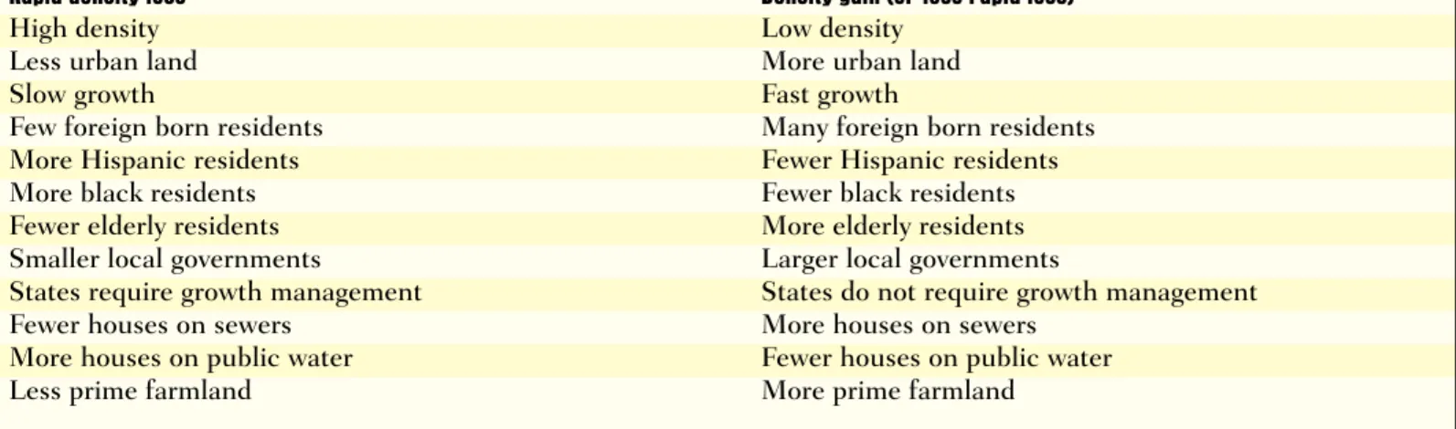
Rapid density loss Density gain (or less rapid loss)
High density Low density
Less urban land More urban land
Slow growth Fast growth
Few foreign born residents Many foreign born residents
More Hispanic residents Fewer Hispanic residents
More black residents Fewer black residents
Fewer elderly residents More elderly residents
Smaller local governments Larger local governments
States require growth management States do not require growth management
Fewer houses on sewers More houses on sewers
More houses on public water Fewer houses on public water
Less prime farmland More prime farmland
Table 6: Regional characteristics that associate with differences in urbanization, 1982-1997
Urbanized more land Urbanized less land
Fast growth Slow growth
High density Low density
Fewer elderly residents More elderly residents
Fewer foreign-born residents More foreign-born residents
More Hispanic residents Fewer Hispanic residents
States require growth management States do not require growth management Highways constitute lower share of budget Highways constitute higher share of budget
Fewer houses on sewers More houses on sewers
Infrastructure endowments and finance also influence sprawl. High-density metropolitan areas depend on sewers, not septic systems, and regions with a full complement of pub-lic infrastructure sprawl less.
Higher-density metropolitan areas tend to have higher shares of houses on sewers than those that are low-den-sity. This relationship is probably mutually supportive; high-density met-ros require sewers, but sewers both enable higher density and promote it by raising land values where sewer is available. Ocala, Florida, is among the lowest-density metropolitan areas in the United States. Its infrastructure may help explain its low density in both 1982 and 1997—only 36 percent of its houses were connected to public sewers. Although Ocala’s density grew by about 8 percent between 1982 and 1997, that growth was not enough to move Ocala from last place in the den-sity rankings nation-wide. And Glens Falls, New York, which started out with moderate density, lost substantial density thanks to its last-in-the-nation percent of households served by public sewers.
However, while public sewers asso-ciate with increasing density (or at least a slower rate of density decline), public water associated with faster density decline when we held constant other variables including the percent of houses on public sewers. The posi-tive effect of sewers outweighs the negative one of public water, however. Metro areas with public sewers often tend also to have public water. The reverse is not true: it is much more common for more houses to have pub-lic water than to have sewers, because many local governments will provide public water without building sewers to avoid or correct groundwater pollu-tion. These findings do not suggest that regions wishing to increase their density should promote public sewer but shun public water; they do, how-ever, indicate that it may be
counterproductive to provide public
water without providing public sewer. Providing public water without provid-ing sewers will likely promote
lower-density development than not providing public water at all, perhaps because when public water is not pro-vided to non-sewered areas,
development tends to be attracted to areas that already have sewers. Metropolitan areas whose school dis-tricts relied heavily on local revenue sources have lower densities. One fiscal factor associated signifi-cantly with density in 1997: metropolitan areas in which local school districts derived most of their revenues from local sources tended to be lower in density than those where state and federal sources provided more revenues. Since so much local educational funding derives from the property tax, this finding reflects the role that the property tax plays in subsidizing public services from a broad base. It may also be an indirect indicator of the results of central city-suburban disparities in educational funding and tax rates. In states where local governments must provide most of the funding for education, central city school districts must often impose high tax rates because their school-children have greater needs and because their residential assessed val-ues tend to be lower than suburban values. Mobile residents often respond by moving to lower-tax suburbs. In future research we intend to develop a measure of central city-suburb tax dis-parity and explore its relationship with sprawl more directly.
Metropolitan areas whose local govern-ments spent more of their budgets on highways urbanized less land. Contrary to our expectations, we found that metropolitan areas in which highways constituted a higher share of local governments’ budgets tended to urbanize less land than those where highways were a small share of the local budget. Local
spend-ing on highways was not a significant factor in either the density or the sprawl analysis; we plan additional research that will show how the total amount spent on highways per capita by all levels of government—federal, state, and local—affects sprawl. This will enable us to determine whether different levels of government spend-ing have different sprawl effects. Government organization, planning policies differ among sprawling and dense metropolitan areas.
Politically “fragmented” metropolitan areas sprawled more.
Metropolitan areas with myriad small local governments sprawl more than those with larger units of local govern-ment (city, township, and county). Many observers have attempted to link sprawl with municipal fragmentation. According to this logic, when metro-politan areas with the same population have very different numbers of local governments, the one with more local governments will have more sprawl. In such a situation, local governments compete more with one another to gain desirable land uses (retail and other non-polluting business uses that yield high property or sales taxes while demanding few services) and to avoid less desirable ones (high-density and affordable housing, which yields lower property taxes and demands more serv-ices, especially education).
Metropolitan areas in states with growth management sprawled more. Ironically, our findings suggest that density dropped more rapidly in met-ropolitan areas in states with
legislation requiring local governments to submit comprehensive growth plans to a state agency for review. It seems unlikely that growth management reduced density; rather, we suspect that states adopted growth manage-ment precisely because they were both growing rapidly and experiencing rapid density declines.
all states dominated by metropolitan areas that gained density between 1982 and 1997—do not have such growth management laws. Among states with growth management, only Florida had several metropolitan areas with rising or steady density. There are, however, at least two plausible scenarios in which growth manage-ment might promote lower density, both of them having to do with prob-lems in carrying out well-designed growth management systems. In some areas, local governments must prepare plans that meet state or regional goals, but higher-level governments lack the clout to ensure that local plans meet the spirit and letter of the law and that municipalities implement their plans. The second scenario is the Florida case. The state requires that infra-structure be in place before growth is permitted, but it failed to fund new infrastructure in the late 1980s and 1990s. Hence new growth has bled into rural areas that had slack infra-structure capacity, largely because growth was foreclosed in suburban areas that had some land left for higher density development but not enough road capacity.
Geographic constraints and agricul-tural productivity slow sprawl. Metropolitan areas that are geographi-cally constrained tend to have higher densities.
Metros that are surrounded by either coastlines, an international border, or other metropolitan areas tend to be denser than those adjacent to at least one rural non-metropolitan county. Metropolitan areas in which more land is in areas with over 15 percent slope are also denser, as are those with more wetlands. Land ownership also makes a difference; metropolitan areas with higher shares of private land have lower densities than those where fed-eral, state, or local governments control more land.
Metropolitan areas rich in prime farm-land have higher densities than others, and sprawled less.
Agricultural productivity also influ-ences density; metro areas with higher shares of prime farmland tend to be more densely developed than those with lower quality farmland, rangeland, or forest land. We suspect that the good soil quality encourages farmers to pay more for the land and to embrace measures that keep land in farming. It is true that prime farmland in metropolitan areas dropped from 76.4 million to 71.0 million acres, a 7.0 percent decline, but even so, metropolitan areas with more prime farmland lost less density than those with little prime land. Madison and Minneapolis-St. Paul are illustrative of this effect. These metropolitan areas are similar in many respects. They both grew about 25 percent in population between 1982 and 1997 and have similar low levels of foreign-born resi-dents, blacks, and Hispanics. But Minneapolis’s density fell 22 percent between 1982 and 1997, whereas Madison’s only dropped 6 percent. Part of the reason for this, we suspect, is because 41 percent of the land in met-ropolitan Madison was prime farmland in 1982, compared with only 32 per-cent in Minneapolis-St. Paul.
IV. Case Studies
A. Los Angeles and New York The Los Angeles and New York CMSAs are the two most populous metropolitan areas in the nation, with approximately 15 million and
18 million residents respectively.5
Traditionally, New York has been viewed as more densely developed, while Los Angeles has been viewed as more low-density and auto-oriented. However, the reality is somewhat dif-ferent. Although it is still extremely dense at its center, New York is sprawl-ing dramatically on the edges.
Meanwhile, although it is still auto-oriented, Los Angeles is “densifying”
dramatically and is developing quite densely even at the fringe. As a result, the overall statistical profile of the two metropolitan areas looks quite similar at a gross scale.
In 1982, New York had a population of 17.5 million people occupying approximately 1.85 million urbanized acres, for an overall metropolitan den-sity of 9.44 persons per urbanized acre. Though smaller and less dense, Los Angeles’s profile was not dramati-cally different even then. In 1982, L.A. had a population of 12.1 million people using 1.49 million acres, for an overall metropolitan density of 8.09 persons per acre.
Over the next 15 years, however, these two metropolitan areas grew in very different patterns. New York added 1.13 million persons and urbanized 478,000 acres of land, for a marginal metropolitan density of 2.37 persons per acre, or less than one-third of its overall average in 1982. L.A. urbanized a little less land (412,000 acres) but increased its population by more than 3.7 million people—a marginal density of 9.12 persons per acre for the entire five-county CMSA. It was one of only 17 metro areas in the nation to increase overall density during this period.
At the end of the 15 years, New York and L.A. looked more alike than ever. New York had 18.6 million peo-ple using 2.33 million acres of urbanized land, for an overall metro-politan density of 7.99 persons per urbanized acre. Los Angeles had 15.8 million people using 1.90 million acres of urbanized land, for an overall met-ropolitan density of 8.31 persons per urbanized acre.
This comparison is useful in under-standing how land is used and how population is accommodated. Like most Northeastern metropolitan areas, New York is expanding its urbanized area largely because of low-density suburban sprawl at the metropolitan fringe, though it is also adding popula-tion in existing urban areas via
immigration. Los Angeles, by contrast, is not growing “up”—in the sense of building New York-style high-rises— but it is becoming denser, for two reasons. First, suburban tract homes on the metropolitan fringe are built much more densely; although there are many six- and seven-unit-per-acre subdivisions, there are very few five-acre lots. Second, immigrant and non-Anglo populations, many of which have modest incomes, are increasing household sizes and doubling up in existing areas, thereby increasing the population density even though the physical fabric does not change much. B. Atlanta and Phoenix
In many ways, Atlanta and Phoenix are “bookend” metropolitan areas—often mentioned in the same breath when discussing Sunbelt growth. Both are booming economically and both are experiencing population growth. Both are “young”—Phoenix quite literally (the metro area was less than 100,000 persons in 1950) and Atlanta more fig-uratively (as the prototypical “New South” metropolis that only began booming in the 1960s). Yet their growth patterns could not be more dif-ferent.
In 1982, Atlanta had a metropolitan population of approximately 2.2 mil-lion persons using 701,000 acres of urbanized land—an overall metropoli-tan density of 3.20 persons per urbanized acre. Even at that time, Phoenix was a dramatically different place. Metro Phoenix had a population of 1.6 million people (72 percent of Atlanta’s population) using only 272,000 acres of urbanized land (39 percent of Atlanta’s urbanized land area), for an overall metro-politan density of 5.91 persons per urbanized acre.
Over the next 15 years, this pattern only became more pronounced. Atlanta and Phoenix added very close to the same population—1.36 million additional people in Atlanta, 1.18 mil-lion additional people in Phoenix.
However, Atlanta urbanized five times as much land to accommodate this additional population as Phoenix did. To put it another way, Atlanta
increased its urbanized land by 81 per-cent to accommodate a population growth of 61 percent. Phoenix increased its urbanized land by only 42 percent to accommodate a popula-tion of increase of 73 percent.
In 1997, therefore, the two metro-politan areas that often seem so similar were more different than ever. Atlanta had a metropolitan population of 3.6 million people and 1.27 million acres of urbanized land—a metropoli-tan density of 2.84 persons per urbanized acre. Phoenix, by contrast, had a metropolitan population of 2.79 million people (77 percent of Atlanta’s population) and 387,000 urbanized acres (30 percent of Atlanta’s urban-ized area)—a metropolitan density of 7.20 persons per urbanized acre.
Phoenix’s growth pattern bears a strong resemblance to Los Angeles’s, with the exception that Phoenix has not been as heavily affected as Los Angeles by immigration and demo-graphic change. It is worth noting, however, that this dramatic contrast between Phoenix and Atlanta has emerged even though Atlanta has con-sumed land far more efficiently than most smaller metropolitan areas in the South. It is also worth noting that a similar comparison could be made between Las Vegas and Charlotte, which have similar growth characteris-tics and almost exactly the same set of differences.
C. Sacramento and Columbus Sacramento, California, and Colum-bus, Ohio, provide an interesting case study that also reveals the dramatic difference in metropolitan growth patterns between the West and the Midwest.
Sacramento and Columbus are similar in many ways. Both are state capitals of large urban states, yet they lie in the center of major agricultural
belts. Both are also home to major universities (Ohio State and UC Davis). Both are growing in population and booming economically, thanks in large part to the high-tech industry’s desire to exploit a well-educated labor pool that has developed because of both the capital and the university. Furthermore, in 1982—the beginning of our study period—they had almost exactly the same metropolitan popula-tion: slightly over 1 million people.
Of course, Sacramento and Colum-bus are located in two regions of the country with vastly different metropoli-tan growth patterns. But in relation to their surrounding regions, both metro-politan areas have atypical growth patterns that ought to make them more similar to one another. Sacramento is sprawling in comparison to most other California metro areas, while Colum-bus is growing compactly compared to most other metro areas in the Midwest.
Yet Sacramento and Columbus have very different metropolitan growth pat-terns—and those differences only became more striking between 1982 and 1997.
In 1982, Sacramento was already much more densely developed than Columbus. At that time, Sacramento had a population of 1.17 million per-sons using 205,000 acres of urbanized land—an average of 5.69 persons per urbanized acre. Columbus in 1982 had a very similar population—1.26 million people. But that population used 316,000 acres of urbanized land. Columbus’s metropolitan density in 1982 was 3.99 persons per urbanized acre. In other words, Sacramento in 1982 was about 50 percent more densely developed than Columbus.
Over the next 15 years, the discrep-ancy grew noticeably—even though Sacramento dropped in overall popula-tion density and sprawled far more than most other California metro areas, including the neighboring farm-ing areas of Stockton and Modesto.
Between 1982 and 1997, Columbus and Sacramento urbanized almost
exactly the same amount of previously non-urban land—about 114,000 acres for Columbus and about 102,000 acres for Sacramento. But Sacramento accommodated more than double the population growth, adding 533,000 new residents to only 258,000 for Columbus. In other words, Sacra-mento grew at a “marginal” population density of 5.23 persons per acre (almost the same as its historical den-sity), while Columbus grew at a marginal density of 2.27 persons per acre, or less than 60 percent of its his-torical density.
At the end of the 15-year study period, Sacramento was accommodat-ing a slightly greater metropolitan population than Columbus on only about 70 percent of the land. In 1997, Columbus had a population of about 1.52 million people using about 430,000 acres of urbanized land, for an overall density of 3.53 persons per urbanized acre (a figure just slightly lower than the national average). But Sacramento had a pop-ulation of about 1.70 persons using about 307,000 acres of urbanized land, for an overall density of 5.53 persons per urbanized acre.
V. Conclusion
I
n closing, it is important toreiter-ate that overall land consumption is just one way to measure “sprawl.” Many other definitions exist, including automobile orientation and issues associated with connected-ness and contiguity of urban areas. Nevertheless, the efficient utilization of land resources is also a commonly accepted definition (or at least a com-ponent) of sprawl. It is especially significant to note that the goal of effi-cient land utilization is being achieved in one region of the country that is commonly perceived to be sprawling— the West—but not in those parts of the nation that are commonly perceived not to have a sprawl problem—the North-east and the Midwest.
This strongly suggests that different parts of the country should approach sprawl as a policy issue in different ways. The West may be more respon-sive to urban design solutions that seek to cluster density and mix com-mercial with residential development to create more efficient activity pat-terns as well as more efficient use of land. The rest of the country, espe-cially the South, may be better off focusing on containment strategies and other efforts to stem the apparent trend of extremely low-density devel-opment on the metropolitan fringe. The Northeast and Midwest may also reduce their trend toward sprawl with-out population growth by redeveloping disused and sometimes contaminated industrial sites and rebuilding estab-lished neighborhoods that have declined.
Demography and growth rates together have a large influence on metropolitan density, and are some-what susceptible to policy actions. Fast-growth regions with high propor-tions of foreign-born residents grew more densely in the 1980s and 1990s than moderately or slowly growing regions with low proportions of for-eign-born residents. “White flight” also seems to be a factor in density change; regions with high proportions of black or Hispanic residents lost density faster than those with lower propor-tions of these minority groups.
Although growth rates and minority composition are difficult to influence with local or regional policy, some declining cities have begun to study the possibility of attracting foreign-born immigrants to their thinning neighborhoods. It is difficult to deter-mine from our results whether such efforts will result in higher overall den-sity; our findings may be an indication that immigrants are attracted to high-density regions, rather than that foreign-born residents cause density to increase. But there is a plausible sce-nario in which immigration does spur increased density. In the first round,
foreign-born residents move into and begin to invest in formerly disused neighborhoods. As the enclave expands and consolidates, property values within the neighborhoods in high demand begin to stabilize and rise. Next, outsiders identify new markets in the central city for additional invest-ment. As a consequence of all these changes, the impression that central cities are not good places to do busi-ness or live begins to fade.
Regional density also relates to infrastructure. Metropolitan areas in which many residents have public water but no public sewers could prob-ably increase the density in
already-developed areas by shifting toward public sewers. Unfortunately for these regions, the era of huge fed-eral subsidies to sewage plant
construction ended over 20 years ago. Without such subsidies from the fed-eral or state government, it is unlikely that municipal governments that already feel little compunction to accommodate higher density develop-ment will tax their residents to build sewers. On the other hand,
researchers have been making huge progress in developing new septic-sys-tem technologies that require much smaller lots. States have been slow to accept these technologies.
A final area that may respond to policy change is regional fragmenta-tion. Dissolution of municipal boundaries seems politically unlikely. But stronger efforts to promote regional cooperation would probably help reduce some of the pressure that seems most likely to promote low-den-sity development in fragmented regions. Fair-share housing programs could assure that more local govern-ments accommodate high-density and affordable housing; tax-base sharing could be designed to reduce the incen-tives for municipalities to compete over new commercial and industrial development.
Appendix A: Methodology
T
he data used in this study were obtained from a variety of sources. The main variable of concern, density, was derived using data from the United States National Resources Inventory (NRI) for 1982, 1987, 1992, and 1997 along with population data from the U.S. Census Bureau. The NRI is a national longitudinal panel survey of land use that allows for analyses of changing trends over a 15-year period. The sample is a stratified two-stage sample of non-federal land in the U.S. and Puerto Rico.6This study onlyexamines states in the U.S. and omits Alaska because the NRI has not yet reported on Alaska. As a sample, the NRI is subject to all the typical errors of sampling. The amount of urbanized land we report here is an estimate. The estimates are probably more accu-rate in counties with more land area, in metropolitan areas with multiple counties, and in metropolitan areas with more urban land use. We have not computed standard errors or confi-dence intervals around these estimates because the USDA has not yet
released software that would make their computation feasible. Future releases of this report will, however, include standard errors and confi-dence intervals around the estimates.
In this study, density is measured as population divided by urban area. The NRI defines urban areas as follows:
Urban and built-up areas. A Land cover/use category consisting of residential, industrial, commer-cial, and institutional land; construction sites; public adminis-trative sites; railroad yards; cemeteries; airports; golf courses; sanitary landfills; sewage treat-ment plants; water control structures and spillways; other land used for such purposes; small parks (less than ten acres) within urban and built-up areas; and
highways, railroads, and other transportation facilities if they are surrounded by urban areas. Also included are tracts of less than ten acres that do not meet the above definition but are completely sur-rounded by urban and built-up land. Two size categories are rec-ognized in the NRI: areas of 0.25 acre to ten acres, and areas of at least ten acres.
For additional information on the NRI, please refer to the NRI web site,
http://www.nhq.nrcs.usda.gov/NRI/ 1997/.
The U.S. Census, by contrast, defines urban areas on the basis of a minimum population density:
The Census Bureau delineates urbanized areas (UA’s) to provide a better separation of urban and rural territory, population, and housing in the vicinity of large places. A UA comprises one or more places (“central place”) and the adjacent densely settled sur-rounding territory (“urban fringe”) that together have a minimum of 50,000 persons. The urban fringe generally consists of contiguous territory having a density of at least 1,000 persons per square mile. The urban fringe also includes outlying territory of such density if it was connected to the core of the contiguous area by road and is within 1 1/2 road miles of that core, or within five road miles of the core but separated by water or other undevelopable ter-ritory. Other territory with a population density of fewer than 1,000 people per square mile is included in the urban fringe if it eliminates an enclave or closes an indentation in the boundary of the urbanized area. The population density is determined by (1) out-side of a place, one or more contiguous census blocks with a
Endnotes
1 William Fulton is President of the Solimar Research Group. Rolf Pendall is an Assis-tant Professor in the Department of City & Regional Planning at Cornell University and a Senior Research Associate at the Solimar Research Group. Mai Nguyen is a Ph.D. student in the Department of Urban Planning at the University of California, Irvine, and a Research Associate at the Solimar Research Group. Alicia Harrison is a Research Associate at the Solimar Research Group.
2 Honolulu, of course, is atypically land-constrained for U.S. metropolitan areas because it is located on an island in the Pacific Ocean. The other major non-conti-nental metropolitan area, Anchorage, Alaska, is not included in this study because NRI does not compile data about Alaska.
3 The extremely large drops in density in Pueblo and Las Cruces suggest a sampling error might be at work. Nevertheless, even if such a sampling error were factored in, it is almost certainly true that the metro density in these metro areas dropped con-siderably.
4 By “associated significantly,” we mean at levels of statistical significance above 90 percent confidence level.
5 This discussion is based on the Consoli-dated Metropolitan Statistical Area—five counties for Los Angeles and 31 counties (in three states) for New York. The profile of the Primary Metropolitan Statistical Area looks quite different.
6 For a detailed description of sampling technique, see Fuller, Wayne A. (1999). Estimation Procedures for the United States National Resources Inventory. 1999 Proceeding of Survey Methods Section of the Statistical Society of Canada.