Final Environmental Assessment
Cedar River Side Channel PL84-99
Replacement Project
King County, Washington
March 2009
Cedar River Side Channel PL 84-99 Replacement Project
King County, Washington
March 2009
Final Environmental Assessment
Responsible Agency: The responsible agency for this project is the U.S. Army Corps of Engineers, Seattle District.
Abstract: This Environmental Assessment is tiered off of the Environmental Impact Statement developed for the Cedar River Section 205 Flood Damage Reduction Study (Final EIS 8/1997). This document evaluates the impacts of the Cedar River Side
Channel Replacement Project. The United States Army Corps of Engineers (Corps), with the City of Renton as the local project sponsor, constructed the Cedar River Section 205 Flood Damage Reduction Project between 1998 and 2000. The project consisted of dredging within, and constructing concrete floodwalls and earthen levees along the lower 1.25 miles of the Cedar River. A groundwater-fed spawning channel constructed near River Mile 5.0 of the Cedar River (within Ron Regis Park) was constructed during this time period to serve as mitigation for the anticipated loss of salmonid spawning habitat in the lower 1.25 miles of the Cedar River following the initial and maintenance river dredging operations. Maintenance dredging was expected to occur every 3 to 10 years to maintain the flood damage reduction benefits. During the February 28, 2001 Nisqually Earthquake, a landslide occurred adjacent to the groundwater spawning channel and resulted in the loss of the channel’s function as off-channel habitat. In response, the City of Renton requested assistance from the Corps under Public Law 84-99 to replace the channel to provide the functional equivalent of the long-term mitigation required for the Cedar River Section 205 Flood Damage Reduction Project. During the summer of 2009, the Corps is planning to construct the Cedar River Side Channel Replacement Project. The proposed work includes replacing the earthquake-damaged side-channel with a new river-fed channel containing habitat features suitable for salmonid spawning and rearing located between River Mile 3.4 and 3.6.
The comment period on the Draft Environmental Assessment was May 1, 2003 through May 31, 2003. The Corps provided another comment period from June 6, 2008 to June 27, 2008, via a Notice of Preparation of this Final Environmental Assessment.
Please send questions and requests for additional information to: Ms. Hannah Hadley
Environmental Resources Section U.S. Army Corps of Engineers P.O. Box 3775
Seattle, Washington 98124-3755 hannah.f.hadley@usace.army.mil 206-764-6950
Final Environmental Assessment Page ii
TABLE OF CONTENTS
1. Introduction... 1
1.1 Location ... 1
1.2 Background ... 2
1.3 Project Purpose and Need ... 2
1.4 Authority ... 2
2. Proposed Action and Alternatives Analysis... 3
2.1 Description of the Proposed Action... 3
2.2 Alternatives ... 4 3. Existing Environment... 5 3.1 Geology ... 5 3.2 Hydrology ... 5 3.3 Water Quality... 5 3.4 Vegetation ... 6 3.5 Fish ... 6 3.6 Wildlife ... 7
3.7 Threatened and Endangered Species ... 7
3.8 Cultural Resources and Native American Concerns... 8
3.9 Land Use ... 8
3.10 Air Quality and Noise ... 8
3.11 Transportation ... 9 3.12 Recreation ... 9 3.13 Aesthetics... 9 4. Environmental Effects... 9 4.1 Geology ... 9 4.2 Hydrology ... 10 4.3 Water Quality... 10 4.4 Vegetation ... 11 4.5 Fish ... 12
4.6 Threatened and Endangered Species ... 12
4.7 Cultural Resources and Native American Concerns... 13
4.8 Land Use ... 13
4.9 Air Quality and Noise ... 13
4.10 Transportation ... 14
4.11 Recreation ... 14
4.12 Aesthetics... 14
5. Unavoidable Adverse Effects ... 14
6. Cumulative Impacts ... 15
7. Coordination ... 15
7.1 National Environmental Policy Act ... 16
8. Environmental Compliance ... 16
8.1 National Environmental Policy Act ... 16
8.2 Endangered Species Act Section 7 Consultation ... 17
Final Environmental Assessment Page iii
Final Environmental Assessment Page iv Cedar River Side Channel Replacement Project March 2009
8.3 Clean Water Act Compliance ... 17
8.4 Coastal Zone Management Act Consistency ... 17
8.5 Hydraulic Permit Approval... 17
8.6 Fish and Wildlife Coordination Act... 18
8.7 National Historic Preservation Act ... 18
8.8 Rivers and Harbors Act (33 U.S.C. 403) ... 18
8.9 Clean Air Act, as Amended (42 U.S.C. 7401, et seq.)... 18
8.10 Magnuson-Stevens Fishery Conservation and Management Act ... 19
8.11 Executive Order 11990, Protection of Wetlands ... 19
8.12 Executive Order 12898, Environmental Justice... 19
9. Conclusion ... 19
10. References ... 21
11. Appendix ... 24
11.1 Final Design Drawings 11.2 ESA and SHPO Concurrence Letters 11.2.1. USFWS Concurrence Letter February 27, 2004 11.2.2. NMFS Concurrence Letter June 10, 2003 11.2.3. NMFS Supplemental Concurrence Letter May 30, 2008 11.2.4. SHPO Concurrence Letter May 20, 2008 11.3 Section 404(b)1) Consistency Determination 11.4 401 Water Quality Certification and Amendment to the Certification 11.5 Public notice 11.6 WDFW Advisory HPA 11.7 Public Comments and Responses 11.7.1. Muckleshoot Indian Tribe Comment Letter - July 1, 2003 11.7.2. Response to the July 1, 2003 Letter 11.7.3. Muckleshoot Indian Tribe Comment Letter - March 15, 2004 11.7.4. Response to the March 15, 2004 Letter 11.7.5. Muckleshoot Indian Tribe Comment Letter - April 24, 2008 11.7.6. Responses to the April 24, 2008 Letter 11.7.7. Muckleshoot Indian Tribe Comment Letter - June 25, 2008 11.7.8. Responses to the June 25, 2008 Letter 11.7.9. WRIA 8 Comment Letter - June 27, 2008 11.7.10. Responses to the June 27, 2008 Letter 11.8 Additional Technical Design Information 11.8.1. Critiques of the Elliot Rearing and Spawning Channel for the Purpose of Design Guidance for the 205 Groundwater Replacement Channel 11.8.2. Hydrology and Hydraulics Design Documentation Report- Cedar River Replacement Mitigation Spawning Channel, Rolling Hills Site A 11.9 Notice of Preparation and Clean Water Act Public Notice LIST OF TABLES Table 1. Protected Species Potentially Occurring in the Project Vicinity ... 7
Table 2. King County Environmental Noise Limits ... 9
Table 3. Channel Spawning-Flow Hydraulic Parameters... 10
1. INTRODUCTION
The goal of the project is to create off-channel spawning and rearing habitat for salmonids (primarily sockeye and Chinook) within the Cedar River basin. The proposed habitat features consist of a side channel between river mile (RM) 3.4 and 3.6 along the Cedar River in the City of Renton, King County, Washington. The new spawning and rearing habitat (about 10,000 square feet) would serve as a functional replacement for the groundwater channel that was destroyed as a result of the 2001 Nisqually Earthquake. The groundwater channel was originally constructed as mitigation for the United States Army Corps of Engineers Cedar River Section 205 Flood Damage Reduction Project. Pursuant to the National Environmental Policy Act (NEPA), this Environmental Assessment is tiered from the 1997 Final Environmental Impact Statement (EIS) for the Cedar River Section 205 Flood Damage Reduction Project, and will assess the narrow topic of the spawning side-channel component of the Flood Damage Reduction Project that had been addressed in that EIS. The contents of the 1997 EIS are incorporated into this EA by express reference. As the EIS has previously conducted a comprehensive evaluation of a spawning side-channel as a mitigation component in the context of the Cedar River Flood Damage Reduction Project, and as the central features of that Flood Damage Reduction Project have been constructed and have long been in operation, this EA will focus primarily on whether the proposed replacement channel constitutes a functional equivalent to the spawning side-channel as assessed in the 1997 EIS, and as it was constructed in the period 1998 through 2000. The EA will also evaluate whether the environmental impacts directly associated with the construction of the replacement side channel are consistent with those evaluated for the original Cedar River spawning channel, and whether the construction-phase impacts would cause significant effects to the quality of the human environment. This EA will not revisit and reevaluate the nature and scope of the mitigation necessary to compensate for the effects of the Cedar River Section 205 Flood Damage Reduction Project, nor will it reassess any other component or parameter of the Flood Damage Reduction Project.
In evaluating whether the proposed action constitutes a functional equivalent to the spawning side-channel being replaced, as it was constructed this analysis will consider whether the proposed action provides a commensurate degree of habitat benefit. Identical replacement is not possible, even if the alternative involving repair of the original, damaged side-channel is selected. Therefore, adequacy of replacement will be addressed in terms of habitat functions established and restored. The original channel, as constructed, will be compared to the preferred alternative to determine whether, as a whole, the proposal provides substantially equal, or
greater, beneficial habitat functions and services. As the impacts of the Flood Damage
Reduction Project, including its side-channel mitigation component, have already been evaluated in the 1997 EIS, that analysis will not be revisited. Furthermore, as the purpose of the side-channel replacement is to provide an environmental benefit, the long-term consequences of each alternative proposed in this EA will not be evaluated. The temporary effects of the proposed action and the assessed alternatives, caused by the side-channel construction process, will be assessed and compared, and the recommended alternative will be evaluated to determine whether the effects on the quality of the human environment are generally commensurate with the side-channel construction effects addressed in the Final EIS, and whether the effects are significant.
1.1Location
This project is located in the floodplain along the left bank between RM 3.4 and 3.6 on the Cedar River in the City of Renton, King County Washington (T21N, R05E, Section 21). The project
Final Environmental Assessment Page 1
Final Environmental Assessment Page 2 Cedar River Side Channel Replacement Project March 2009 location is east of the Royal Hills Neighborhood; west of the Maple Garden Neighborhood within City owned property.
1.2Background
The Seattle District, United States Army Corps of Engineers (Corps), with the City of Renton as the local project sponsor, constructed the Cedar River Section 205 Flood Damage Reduction Project between 1998 and 2000. The project consisted of dredging within, and constructing concrete floodwalls and earthen levees along the lower 1.25 miles of the Cedar River.
A groundwater-fed spawning channel constructed near River Mile 5.0 of the Cedar River (within Ron Regis Park) was constructed during this time period to serve as mitigation for the
anticipated loss of salmonid spawning habitat in the lower 1.25 miles of the Cedar River following the initial and maintenance river dredging operations. This ground-fed channel including the groundwater collection pond was approximately 24,000 square foot in size with one braided portion. From the pond, the channel flowed approximately 1100 feet into the Cedar River. Maintenance dredging was expected to occur every 3 to 10 years to maintain the flood protection benefits. To date, no maintenance dredging has been done.
During the February 28, 2001 Nisqually Earthquake, a landslide occurred adjacent to the groundwater spawning channel. The landslide blocked the mainstem river and flow was
eventually diverted along the alignment of the original spawning channel. Diversion of the main flow through the spawning channel resulted in the loss of the original channel’s function as off-channel habitat. In response, the City of Renton requested and obtained assistance from the Corps under Public Law 84-99 to replace the channel to provide the long-term mitigation required for the Cedar River Section 205 Flood Damage Reduction Project.
1.3Project Purpose and Need
The purpose of this project is to reestablish a salmonid spawning and rearing side-channel along the Cedar River functionally equivalent to the Section 205 spawning channel1 destroyed by the Nisqually earthquake.
1.4Authority
The Cedar River Side Channel Project is authorized by Public Law 84-99 (33 USC 701n). Corps rehabilitation and restoration work under this authority is limited to flood control works damaged or destroyed by flood. The rehabilitated structure will normally be designed to provide the same degree of flood damage reduction as the original structure. Because the 1998 groundwater-fed side channel was an essential feature of the Section 205 Cedar River Flood Damage Reduction Project, the PL84-99 authority authorizes its rehabilitation or replacement.
1
The mitigation provided by the original side channel is described in the final environmental impact statement for the Cedar River Section 205 Flood Damage Reduction Study (Corps 1997).
Final Environmental Assessment Page 3 Cedar River Side Channel Replacement Project March 2009
2. PROPOSED ACTION AND ALTERNATIVES ANALYSIS
2.1Description of the Proposed Action
The project consists of the following design elements to create an approximately 10,000-square foot salmonid spawning and rearing side-channel with a reliable water source and habitat complexity:
• The construction of an intake structure (consisting of concrete box culvert, trash rack, control valve, geogrids, and approximately 140 feet of pipe) at the upstream end of the channel to convey from the Cedar River.
• The construction of an open-channel outlet approximately 1,150 feet downstream from the intake structure in order to allow flow to re-enter the Cedar River and adult/juvenile fish to migrate to or from the channel.
• The excavation of approximately 14,000 cubic yards of floodplain sediments2 (i.e., gravel, sand and silts) and shaping for a distance of 950 feet within the existing drainage course in order to create the replacement channel, with an average bottom dimension of 10 feet.
• The addition of anchored large woody debris into five alcoves to create rearing habitat and to provide cover within the constructed channel.
• The addition of anchored large woody debris into the channel bank at several locations to create pool habitat.
• Large woody debris partially buried into the left bank upstream from the outlet to stabilize the bank.
• The addition of 600 to 900 cubic yards of gravel to create spawning habitat.
• The construction of a 12-foot wide gravel-surfaced maintenance path adjacent to the west side of the channel for the length of the project.
• The installation of native trees, shrubs and plants at two locations – along the new channel and between the Cedar River and the new channel within an existing disturbed area – in order to mitigate for vegetation disturbance and tree removal (approximately 60 to 100 cottonwood and alder trees) resulting from the construction of the channel and maintenance road.
• The installation of a gate across the access road to deter illegal vehicular access. • The installation of educational signs to inform the public of salmon within the Cedar
River basin as well as the impacts of illegal activities on the habitat area.
Project construction is anticipated to be during the summer of 2009, with in-water work
occurring June 16th through August 15th. Project plantings would likely occur during the fall of
2
The quantity of material excavated from the side channel is amended from the draft EA and NOP based on updated calculations; the design prism has not changed.
2009. Future maintenance work may be necessary for cleaning and/or repair of the channel, including the intake structure and outlet.
2.2Alternatives
The Corps evaluated a variety of alternative sites during development of the project. Criteria used to evaluate the suitability and functional equivalency of the different sites included adequacy of size to replace lost sockeye spawning and Chinook rearing habitat, risk of future landslide, risk of channel migration, flood frequency, risk of vandalism/poaching, ease of operation and maintenance, construction access, land rights, and habitat functions and services. Initial evaluation narrowed down the list of potential alternatives to those described below, which were further analyzed for consistency with the site criteria.
No Action. The no action alternative would not repair or replace the groundwater-fed spawning channel constructed near River Mile 5.0 of the Cedar River (within Ron Regis Park) that was destroyed as a result of a landslide triggered by the February 28, 2001 Nisqually Earthquake. The landslide changed the main flow of the river resulting in the loss of the channel’s function as off-channel salmonid spawning and rearing habitat. The no-action is not a viable alternative since it does not meet the project purpose; the no-action alternative will be carried forward as the basis for evaluating impacts of other action alternatives.
Repair of the Earthquake Damaged Channel. This alternative would have required diverting the current mainstem flow of the Cedar River and removing approximately 40,000 cubic yards of slide debris to reopen the river channel. In addition, a control structure on the upstream end of the original channel might be necessary. This alternative was not selected because of the high threat of additional slides closing the side channel again and impacts of diverting the entire current flow of the mainstem Cedar River.
Modification to the Existing Elliot Channel. This alternative would involve modification of the existing Elliot Spawning and Rearing Channel, located along the left bank just downstream of RM 5 on the Cedar River, in an attempt to increase the available productivity of existing channel. This would include supplementing the existing project with more large woody debris, plantings, and spawning gravel as necessary. However, this channel is currently functioning with an adequate rate of production and modification to the channel might have adverse affects to sockeye production and other fish and wildlife species. The potential increased rate of flooding due to the 2001 landslide upstream was a consideration for not selecting this alternative. Creation of a New Channel at the Renton Elks Club This alternative would have created a replacement spawning/rearing side-channel on the Renton Elks Club property. The problem with this site was that it was adjacent to an actively sliding area and there were concerns that any new projects near this site were likely to be eliminated in a future slide.
Final Environmental Assessment Page 4
3. EXISTING ENVIRONMENT
3.1Geology
The northwest/southeast trending valleys that contain the Cedar River, and Lakes Sammamish and Washington were formed by the most recent retreat of glaciation approximately 10,000 years ago. The soils are generally glacially deposited, such as till, outwash or glaciolacustrine
deposits. The Cedar River valley is composed primarily of alluvium deposited with the
meanderings of the Cedar River across its floodplain. Gravels are deposited in many areas of the floodplain, and flow from the river through these gravel deposits manifests itself in the form of groundwater flow where floodplain soils have been excavated. The floodplain soils at the project site are a mix of gravels, sands, and silts from successive flooding events. The project site lies along the southern shore of the Cedar River and occupies a floodplain terrace below a steep valley slope. The riverbank is abrupt and appears stable. One swale runs immediately at the base of the valley slope. Another occupies a linear depression at the base of a minor terrace escarpment midway between the valley slope and the river. The proposed spawning channel would occupy the second swale, which becomes more defined toward the downstream end of the site. At its highest, the terrace rises about 10 feet above the left side (looking downstream) of the swale.
3.2Hydrology
Flows in the Cedar River are regulated by the Masonry Dam (RM 36) and Landsburg Diversion Dam at RM 21.9. At the project site, the annual minimum flow in the Cedar River during the early sockeye spawning season (in September) is about 100 cubic feet per second (cfs). Later in the fall during peak sockeye spawning season, flows would typically be about 400 cfs. The Cedar River 10-percent exceedance flow (a 10 year recurrence interval) is slightly less than 6,000 cfs. The 2-percent exceedance flow (a 50-year recurrence interval) is estimated at just less than 10,000 cfs and the 1-percent exceedance flow (a 100-year recurrence interval) is about 11,500 cfs. The floodplain where the rearing/spawning channel will be constructed is inundated with river water during flows greater than about 5,500 CFS, which is about a 5 to 10 year recurrence interval flow.
3.3Water Quality
In the vicinity of the proposed rearing/spawning channel (RM 3.1), the State of Washington classifies the Cedar River as core summer habitat for aquatic life uses, primary contact for recreational uses, approved for all water supply uses, and miscellaneous other uses (from WAC 173-201A-602). During heavy rainstorms and floods there are temporary periods of high turbidity, but otherwise there are no other water quality issues. The Washington Department of Ecology classifies the reach of the Cedar River immediately adjacent to the project site as
meeting tested standards for clean waters. Downstream of the project site, the reach of the lower Cedar River between Interstate 405 and Lake Washington occasionally exceeds state water quality criteria for temperature and fecal coliform.
Final Environmental Assessment Page 5
Final Environmental Assessment Page 6 Cedar River Side Channel Replacement Project March 2009
3.4Vegetation
The most prevalent community that occurs throughout the site and surrounding area is a cottonwood/alder forest with an understory of snowberry, salmonberry, buttercup, nettle, and sword fern. In places, vine maple, blackberry, Indian plum, Japanese knotweed, bleeding heart, giant horsetail, and Pacific waterleaf occur. The only wetland in the vicinity of the construction consists of a 300 square foot (0.007 acre) patch that is vegetated with snowberry, salmonberry, and sword fern. The wetland occupies a relatively long, narrow low spot in the swale that is located along the approximate alignment of the proposed side channel. Locations of all trees greater than 6-inch diameter located within 25 feet of the centerline of the proposed channel are shown on the drawings in Appendix 11.1.
3.5Fish
According to the EIS for the Cedar River 205 Flood Damage Reduction Project prepared in August of 1997, there are at least 22 species of fish present in the Cedar River. In the vicinity of the project site, fish species present include sockeye salmon, Chinook salmon, coho salmon, steelhead, rainbow trout, cutthroat trout, mountain whitefish, northern squawfish, peamouth chub, three-spine stickleback, largescale sucker, longnose dace, brook lamprey, Pacific lamprey, and several species of sculpin. Bull trout have not been observed in the vicinity of the proposed project, but may occur as sporadic migrants either from the upper watershed or on forays from Puget Sound and Lake Washington.
The Cedar River adjacent to the proposed project is heavily utilized for spawning by adult sockeye, Chinook and coho salmon. The existing natural side channels in the vicinity are utilized for rearing by sockeye fry, Chinook fry and juveniles, coho and steelhead smolts. Sockeye salmon are the most numerous salmonid species in the river and in the Lake Washington basin as a whole. Approximately 80 percent of the Lake Washington sockeye population spawns in the Cedar River. Annual escapement3 ranges from less than 50,000 to more than 500,000 adult fish. Adults enter the Cedar River from late August through December, with spawning occurring through mid-January. Emerging fry rapidly migrate downstream to Lake Washington at night from late January through May. The peak of the outmigration occurs in March and April.
Sockeye salmon typically spawn in streams that flow into large lakes systems to allow juvenile sockeye to rear for a year or more in a deepwater lake environment before migrating to sea. Prior to the 1930s, Lake Washington was famous for its large populations of kokanee (the freshwater form of the sockeye). In the year 1916, the ship canal was opened to serve as a new outlet for Lake Washington and to provide the water needed to operate the just completed Hiram M. Chittenden Locks at Ballard. This combined the extensive spawning grounds of the Cedar River with a large lake-rearing environment, provided an opportunity to develop a major sockeye salmon population in the waters of southern Puget Sound.
Sockeye were introduced into the Lake Washington watershed in 1935 (and subsequent years) from the Baker River. The first documented adult returns to Lake Washington were in 1940
3
when 9,099 sockeye were counted at the Washington Department of Fisheries hatchery on Issaquah Creek. The run gradually increased, and in 1970 an escapement goal of 350,000 spawners was adopted and in 1971 the first directed fisheries occurred. Since then, sockeye returns have significantly fluctuated despite supplementation efforts and harvest restrictions, theoretically due to freshwater and ocean survival constraints, and because of an increased frequency in damaging winter floods (WDFW 2002).
Chinook and coho salmon are present in smaller numbers than sockeye. WDFW rates the stock status for both Cedar River Chinook and coho as depressed. Escapement for Chinook ranges from less than 200 to more than 1500 adult fish. Chinook and coho enter the Cedar River in the early fall through mid-winter, with Chinook run timing and spawning starting and ending earlier. Chinook fry emerge from gravels from February through April and may rear for a short period in the river prior to moving downstream into Lake Washington. Coho emerge from gravels starting early in the year and continue through spring. Coho juveniles rear in stream habitats until they migrate out to sea about one year after emerging.
3.6Wildlife
Wildlife species likely to be present at the site and surrounding area are black-tailed deer, cougar, muskrat, coyote, raccoon, eastern gray squirrel, opossum, beaver, cottontail rabbits, striped skunk, Norway rats, various small rodents, and feral dogs and cats. Red tailed hawks and bald eagles utilize the taller cottonwoods for perching and foraging. Mergansers, mallards and other waterfowl are present.
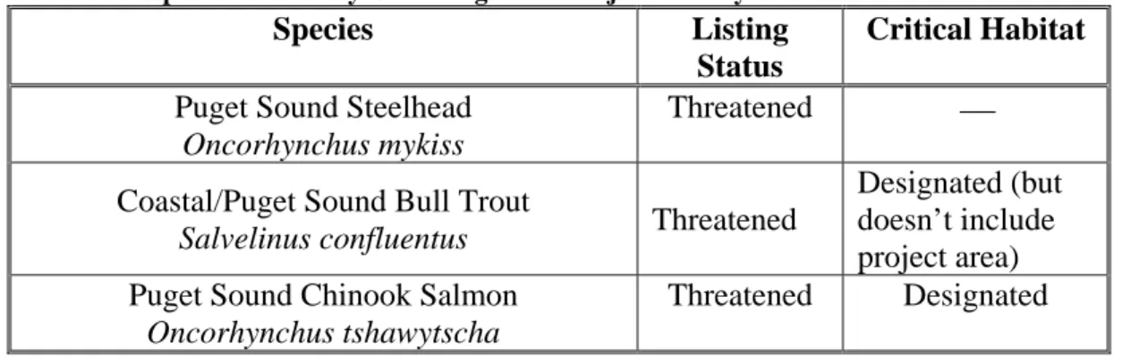
3.7 Threatened and Endangered Species
Three species listed as threatened under the Endangered Species Act are likely to occur in the project area, including Puget Sound steelhead, Puget Sound ESU Chinook salmon, and Puget Sound/Western Washington ESU bull trout. In addition, coho salmon, a species of concern, are located in the vicinity of the site.
In accordance with Section 7(a)(2) of the Endangered Species Act of 1973, as amended, federally funded, constructed, permitted, or licensed projects must take into consideration impacts to federally listed and proposed threatened or endangered species. Several species listed as either threatened or endangered are potentially found in vicinity of the project (Table 1).
Table 1. Protected Species Potentially Occurring in the Project Vicinity
Species Listing Status
Critical Habitat
Puget Sound Steelhead
Oncorhynchus mykiss
Threatened ⎯
Coastal/Puget Sound Bull Trout
Salvelinus confluentus Threatened
Designated (but doesn’t include project area) Puget Sound Chinook Salmon
Oncorhynchus tshawytscha
Threatened Designated
Final Environmental Assessment Page 7
3.8Cultural Resources and Native American Concerns
A Corps archeologist in coordination with Muckleshoot Tribe and the State Historic Preservation Office conducted a cultural resources survey resulting in the determination that there are no known cultural resources in the project area.
3.9Land Use
The project site and adjacent property to the south and east is owned by the City of Renton. All City of Renton property (i.e. site and adjacent parcels) is considered a natural zone area. The proposed location has a City of Renton zoning designation as a Resource Conservancy. Located to the west of the project site is a City of Seattle right of way for the East Side Supply Line, which is a 36” water main supplying water the east side of Seattle. Developing residential areas are located on areas overlooking the Cedar River valley to the south of the project site along the access route to the project site. Property across the river is occupied by private residences.
3.10Air Quality and Noise
Air Quality
In accordance with the Clean Air Act and its amendments, National Ambient Air Quality Standards (NAAQS) have been established by the Environmental Protection Agency (EPA) for several criteria pollutants including lead (Pb), ozone (O3), carbon monoxide (CO), sulfur dioxide (SO2), nitrogen dioxide (NO2), total suspended particulates (TSP), and particulates with aerodynamic diameters of less than 10 microns (PM10 and PM2.5). Three agencies have jurisdiction over air quality in the project area: the EPA, Ecology, and the Puget Sound Clean Air Agency. These agencies establish regulations that govern both the concentrations of pollutants in the outdoor air and contaminant emissions from air pollution sources. Although their regulations are similar in stringency, each agency has established its own standards. Unless the state or local jurisdiction has adopted more stringent standards, the EPA standards apply. The project area is classified as an attainment area for all criteria pollutants except CO, ozone, and PM10. For CO and ozone, the region is classified as a maintenance area, which is a provisional attainment status that must be maintained for several years before being reclassified as full attainment. There are three pockets of PM10 non-attainment areas in the region, including industrial areas in Seattle, Kent, and the Tacoma Tideflats. The project site is located outside of these areas.
Noise
State, county, and local noise regulations specify standards that restrict both the level and duration of noise measured at any given point within a receiving property. The maximum permissible environmental noise levels depend on the land use of the property that contains the noise source (e.g., industrial, commercial, or residential) and the land use of the property
receiving that noise. The King County noise standards are shown in Table 2. The King County residential noise standards would be applicable at the project site.
Final Environmental Assessment Page 8
Table 2. King County Environmental Noise Limits
3.11Transportation
Residential streets are in the project vicinity. There is a gravel utility road adjacent to the
proposed project site and an access road (upper portion is paved and lower portion is gravel) into the proposed project site. Currently, a gate located on the existing utility road restricts vehicular access to the proposed project site. However, illegal entry by motorized vehicles is not
uncommon.
3.12Recreation
The current use of the proposed location is an open space with limited public hiking/walking trails. However, current legitimate use is limited and illicit use common.
3.13Aesthetics
The proposed project area is located in the wooded flood plain across the Cedar River from several City of Renton residents. Currently, these residents enjoy a view of a wooded stand of mature cottonwoods and occasional wildlife sightings.
4. ENVIRONMENTAL EFFECTS
4.1Geology
About 14,000 cubic yards of floodplain deposits will be excavated to construct a new spawning and rearing channel within the existing floodplain. The channel will be aligned along the course of a former side channel. Approximately 3000 -5000 cubic yards of suitable material will be beneficially used to repair existing access roads that are currently rutted. The remaining excavated material will be temporarily stockpiled at the staging area, approximately .25 miles upland of the side channel prior to being hauled offsite. Authorized reuse or proper disposal of the stockpiled material will be the responsibility of the construction contractor. Using the no-action alternative as a benchmark for the existing environment in comparison to construction effects, the proposed earth moving will have less than significant effects on the geology and physical setting of the project site.
Final Environmental Assessment Page 9
4.2Hydrology
Depths in the channel would average between 0.75 and 1.0 feet for most of the channel until the outlet to the river during ninety percent exceedance flows (Table 3). Here, river backwater increases depths to up to 2.5 feet. Velocities in the channel would range between 0.4 feet per second at the mouth to 2.5 feet per second at the riffle just upstream of the new channel outlet. Average channel velocities would be between 1.2 and 1.6 feet per second for most of the channel length.
Table 3. Channel Spawning-Flow Hydraulic Parameters
Spawning Period Minimum
Flow (cfs) in River based on Cedar HCP Max Flow (cfs) in Channel (Flow at 6” gate opening) Range of Depth (ft) (Average) Range of Velocity (fps) (Average) Summer Lowest Q 97 6 (5) 0.3-1.7 (0.6) 0.3-1.6 (1.0) 16-22 Sept1/ 150 7 (6) 0.4-1.7 (0.7) 0.3-1.5 (1.1) 1-7 Oct1/ 270 10 (8) 0.6-2.0 (0.9) 0.3-1.5 (1.2) “90%Exceed” 300 11 (8) 0.7-2.1 (0.9) 0.3-1.5 (1.2) Peak Critical 240 10 (7) 0.6-1.9 (0.8) 0.3-1.6 (1.2)
Peak Low Normal 440 14 (9) 0.8-2.5 (1.1) 0.3-1.6 (1.3)
Peak High Normal 470 14 (10) 0.9-2.6 (1.1) 0.3-1.6 (1.3)
1/ Normal minimum during early spawning period
The side channel intake will divert a portion of the river flow into the side channel at all river flows. The minimum critical Cedar River flow is 97 cfs per the City of Seattle Habitat
Conservation Plan. At this flow rate about 5 to 10 cfs will be conveyed into the new channel. The maximum design flow in the new channel is about 50 cfs. This flow would occur when Cedar River flows are at about 5,500 cfs just prior to levee overtopping.
Flow from the Cedar River will enter the channel at the inlet of the new channel and return to the Cedar River after flowing within the new channel system for a distance of about 1,200 ft. Using the no-action alternative as a benchmark for the existing environment in comparison to
construction effects, diversion of flow from the mainstem river into the side channel will have less than significant effect on the river hydrology in the project reach of the river.
4.3Water Quality
With the exception of the inlet and outlet structures, the project will be constructed without any in-water work. This means that Cedar River water quality will not be directly affected during the clearing/grading and excavation work elements related to channel construction. Work to connect the channel to the river will likely generate increased turbidity in the river; turbidity is expected to fall within state water quality standards within 300 feet downstream of the work limits. This
Final Environmental Assessment Page 10
is consistent with the temporary turbidity mixing zone under the 401 Water Quality Certification. Water quality monitoring will be turbidity sampling of a minimum of every two hours
throughout the first day of in-water construction activity, pursuant to the 401 Certification. Other impacts to water quality during construction are not anticipated.
Following construction, the intake structure will divert flows into the side channel at all river flows. The presence of flow in the side channel at all river stages and seasons – including the 5-10 cfs anticipated when the Cedar River is at minimum critical flow – will help ensure that water quality in the side channel is suitable for salmonid rearing and spawning during the appropriate seasons. Pursuant to the 401 Certification, diversion into the replacement spawning side-channel will only be initiated following approval by the WDFW.
The project will utilize best management practices (BMPs), such as silt fencing and other erosion control measures, to ensure no sediments enter the river during construction, and all cleared areas will be mulched, seeded and planted to prevent storm water runoff after construction. The project is limited to in-river construction between the dates of June 16 and August 15 in order to reduce impacts to salmonids. With implementation of the above-mentioned BMPs, construction will result in less than significant effects to water quality, using the no-action alternative as a benchmark for the existing environment in comparison to construction effects,.
4.4Vegetation
The channel and maintenance road were designed to minimize the impact on the existing vegetation. In total, the project will involve construction over about 12.5 acres of the forested floodplain terrace. Between 60 and 100 trees greater than 6-inch diameter will be felled during construction. Field engineering adjustments will be made to avoid removing trees whenever possible. Except for in the immediate vicinity of the channel intake and outlet, the bulk of the tree cutting will occur inland from the river shoreline and consequent adverse effects associated with nearshore riparian vegetation will be minimal.
The channel construction will convert a 300 square foot (0.007 acre) wetland, located within the construction footprint, to side channel habitat, encompassing approximately 10,000 square feet. Vegetation within this small wetland is similar to the adjacent area including the rest of the project site. Outside of this wetland area, the remainder of the site appears to be well drained and the steep riverbank precludes any sort of wetland fringe associated with the shoreline. This wetland represents a small portion of the overall amount of wetlands in the watershed and is not functionally unique to the watershed. Spawning and rearing habitat is a limited resource and thus provides a unique function in this watershed. The conversion of the wetland is anticipated to be off-set by the functional benefits gained by the addition of the side channel habitat to the watershed. In addition, the alcoves in the constructed channel are shallow and there is a high likelihood that in excess of the filled 300 square feet of wetlands could develop in those areas, which could replace the loss of the wetland.
Native trees and shrubs (i.e. douglas fir, pacific willow) will be planted in disturbed areas as mitigation for construction of the channel and maintenance path. The ratio of trees to be replanted is 3 to 1, assuming 100 trees are removed during construction. If fewer trees are removed, the ratio of replanting could increase to as much as 5 to 1. This does not include the
Final Environmental Assessment Page 11
willow plantings. Willow stakes will be planted along portions of the new channel. The trees and shrubs will be planted in two locations. First, planting will occur in areas that are disturbed to construct the new channel (with the exception of the channel bottom). Second, an existing disturbed area between the Cedar River and new channel will be planted to control runoff and deter access along a beaten path to the river. Pursuant to conditions in the Water Quality Certification and Hydraulic Project Approval that applies to the project, the City of Renton will monitor and maintain all plantings at three intervals through year 5 to ensure at least 80 to 90 percent survival, as specified in the 1997 EIS. Planting will occur in fall of 2009.
In summary, the project will result in removal of some forested area that currently occurs on the terrace. Plantings will be installed following construction and, as these plantings mature, vegetation conditions at the site will gradually transition to the forested characteristics that currently occur; therefore, no long-term effects to vegetation would occur. Temporal effects from vegetation removal would be minimal because the site has been overplanted to compensate for temporal loss and the vegetation in the surrounding area is similar to the project site. Using the no-action alternative as a benchmark for the existing environment in comparison to
construction effects, this project will have less than significant effect on vegetation, including wetlands.
4.5 Fish
The construction of the proposed alternative will involve short-term disturbance to the Cedar River at the new channel’s upstream and downstream ends. In-water work would occur during the work window for the project, June 16 though August 15. Therefore, the project’s effect on fisheries would be short-term and less than significant, using the no-action alternative as a benchmark for the existing environment in comparison to construction effects.
4.6 Threatened and Endangered Species
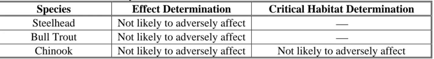
A Biological Evaluation (BE) was prepared and submitted to National Marine Fisheries Service (NMFS) and the U.S. Fish and Wildlife Service (USFWS) on July 30, 2002. Supplemental documentation was submitted to NMFS on May 9, 2008. The BE and supplement concluded that the proposed project is not likely adversely affect any species protected under the Act,
largely because construction will occur when Chinook, steelhead, and bull trout are least likely to be present in the project area, and the project will provide approximately 10,000 square feet of off-channel habitat. The individual effect determinations made in the BE are summarized in Table 4. A concurrence letter from the USFWS was received February 27, 2004. Concurrence letters from NMFS were received June 10, 2003 and May 30, 2008. (Appendix 11.2)
Pursuant to the HPA issued to it by the WDFW, the City of Renton Surface Water Utility will be required to monitor and maintain the channel over a five-year period, to meet the success
standards prescribed by that HPA to provide spawning and rearing habitat. Monitoring will include: adult and redd counts, fry production surveys, and riparian habitat monitoring, as specified in the 1997 EIS. Maintenance will include: cleaning and/or repair of entire channel including intake structure and outlet.
Final Environmental Assessment Page 12
Construction will occur when Chinook, steelhead, and bull trout are least likely to be present in the action area. The in-water work is scheduled to occur between June 16 and August 15, in accordance with the fish windows created by WDFW. The project would create approximately 10,000 square feet of salmonid spawning and rearing side-channel. Using the no-action
alternative as a benchmark for the existing environment in comparison to construction effects, the project, therefore, would result in less than significant impacts to threatened and endangered species.
Table 4. Determination Summary Table
Species Effect Determination Critical Habitat Determination
Steelhead Not likely to adversely affect ⎯
Bull Trout Not likely to adversely affect ⎯
Chinook Not likely to adversely affect Not likely to adversely affect
4.7Cultural Resources and Native American Concerns
Using the no-action alternative as a benchmark for the existing environment in comparison to construction effects, no known cultural or historic sites occur in the project area and therefore no impacts would be anticipated to occur. However, if any artifacts or cultural resources are
discovered during construction, all work will be stopped and the Corps archeological and cultural resources staff will further investigate the site and alert the appropriate authorities.
4.8Land Use
The project site and adjacent property to the south and east is owned by the City of Renton. All City of Renton property (i.e. site and adjacent parcels) is considered a natural zone area. This project will not change the land use of the project area and it will continue to be considered a natural zone. The local sponsor will obtain the easements and permits, and the Corps will control construction and equipment use practices, to ensure that project construction will not adversely affect the City of Seattle water pipeline located along the construction access route between Rolling Hills Drive NE and the project site. Using the no-action alternative as a benchmark for the existing environment in comparison to construction effects, less than significant effects to land use, therefore, would occur.
4.9Air Quality and Noise
Construction activities will occur during daylight hours, 5 days a week. The nearest residence is located across the river approximately 300 feet from the project site and the subdivision, Royal Hills is located approximately 0.3 miles from the project site. There will be a temporary increase in noise during construction; however effect of construction noise will be minimal given the distance the residences are from the project site. Emissions from construction activities such as excavation and hauling are anticipated to be below the EPA’s de minimis threshold levels (100 tons/year from CO and 50 tons/year from ozone). In addition, equipment such as dump trucks, excavator, and dozers will have mufflers and exhaust systems in accordance with State and Federal standards. Any effects to air quality will be short term; only during construction. The construction-phase air quality effects are not expected to exceed the standards of 40 CFR
Final Environmental Assessment Page 13
93.153(b)(1) for applicable criteria pollutants, and a conformity determination is therefore not required. Following construction, there will be no change in air quality, noise or light
parameters. Using the no-action alternative as a benchmark for the existing environment in comparison to construction effects, impacts to air quality and noise will be less than significant.
4.10Transportation
Vehicle traffic in the area will increase during construction, as dump trucks will be needed to transport the materials excavated during the creation of the channel offsite. Depending on the amount of material used to repair the access road, approximately 450 to 550 truck trips would occur hauling the remaining material offsite, using residential streets. However, this increase in traffic will be localized and of short duration, with no long-term impacts. The project includes improvements to the gate across City of Seattle right-of-way that is expected to deter illegal vehicular traffic near the project site. Using the no-action alternative as a benchmark for the existing environment in comparison to construction effects, transportation related impacts will be less than significant.
4.11Recreation
During construction, public access will be restricted on the site. Following construction, the site will be available for passive recreation as appropriate for a natural area. Interpretive signs will be placed on-site to provide information the following issues: wildlife poaching; trail use impact; salmonid spawning; and benefits of project. Using the no-action alternative as a benchmark for the existing environment in comparison to construction effects, impacts to recreation would be short term and therefore, less than significant.
4.12 Aesthetics
Significant efforts and consideration have been made to maintain the project location’s
aesthetics, as well as maintain the wooded view for City of Renton residents who live across the Cedar River from the project site. The location of the channel has been designed to minimize the number of large diameter trees that will be removed during construction. Final alignments of the channel will be field engineered to help preserve the maximum number of large diameter trees. Native plants and trees will be planted in the disturbed area, with the exception of the channel bottom. In addition, an existing disturbed area along the river will be planted with native trees and shrubs to maintain a buffer that will allow for a wooded view for the residents located across the river from the project location. Wildlife sightings in the area are likely increase due to the projected abundance of salmon in the channel. Using the no-action alternative as a benchmark for the existing environment in comparison to construction effects, impacts to aesthetics would be less than significant.
5. UNAVOIDABLE ADVERSE EFFECTS
Unavoidable adverse effects associated with this project include: (1) a temporary and localized increase in noise, which may disrupt wildlife in the area, (2) a temporary and localized disruption of local traffic by construction vehicles, and (3) a temporary and localized increase in turbidity levels during construction of the intake and outlet structures in the Cedar River, which may affect aquatic organisms in the area. However, these potential impacts will be short in duration and considered insignificant.
Final Environmental Assessment Page 14
6. CUMULATIVE IMPACTS
Cumulative effects include the effects of other past, present, and reasonably foreseeable future Federal, State, tribal, local or private actions in the action area considered in this evaluation. Seattle Public Utilities proposes to construct and operate a sockeye hatchery and associated facilities on the Cedar River. The project would consist of a hatchery, a system to supply virus-free water for hatchery operations, and broodstock collection and spawning facilities. The new hatchery would be located within King County, about two miles northeast of Ravensdale and three miles southeast of Maple Valley. The broodstock collection facility would be located on the lower Cedar River, possibly within several hundred feet of the Corps proposed replacement side-channel. Several WSDOT projects such as widening I-405 across Cedar River, are
proposed in the project vicinity. The long-term cumulative environmental effects of the Cedar River Flood Damage Reduction project – including the mitigation component provided by the spawning side-channel – have been fully evaluated in the EIS. As discussed previously, the proposed project would implement a functionally equivalent replacement for the spawning side-channel destroyed in 2001, and is anticipated to provide a net habitat benefit. Therefore, the recommended alternative is not anticipated to generate incremental adverse effect on the quality of the human environment, when considered in conjunction with other past and present actions, and future proposals.
7. COORDINATION
Design of this project was extensively coordinated with the public, the Muckleshoot Indian Tribe, and resource agencies including: the City of Renton, King County, the U.S. Fish and Wildlife Service, the National Marine Fisheries Service, the Washington Department of Fish and Wildlife, the Washington Department of Ecology, the University of Washington- School of Fisheries, and the Department of Fisheries and Oceans- Canada.
A resource agency coordination meeting was held on July 18, 2001 to discuss the replacement criteria of the Section 205 Groundwater Spawning channel destroyed by the earthquake and to rank potential replacement sites. Attendees included: the City of Renton, the Corps, WDFW, EFH Consulting, the USFWS, and the University Of Washington School Of Fisheries. Additional technical design input regarding critiques of the Elliot Rearing and Spawning
Channel for the Purpose of Design Guidance for the 205 Groundwater Replacement Channel was received from Department Fisheries and Oceans- Canada, NMFS, USFWS, WDFW, WDOE, King County, R2 Resource Consultants, Golder Associates Inc., NHC Inc., and Perkins GeoSciences (see Appendix 11.8).
On February 15, 2002, the City of Renton conducted a site visit to discuss the proposed project with local citizens.
On March 7, 2002, a follow-up multi-agency design team meeting discussed in detail the top two alternative replacement sites- the Rolling Hills site and the alternative of potentially enhancing the Elliot Side Channel Site.
Final Environmental Assessment Page 15
On February 26, 2002, the Corps and the City of Renton participated in the Cedar River Council public meeting to discuss the replacement of the damaged side channel. Shortly after, a follow-up presentation was offered to the City of Renton City Council public meeting.
Public coordination per the NEPA is discussed in Section 7.1 below.
7.1National Environmental Policy Act
The original Cedar River Section 205 Flood Damage Reduction Project, which included the original side channel that was destroyed in the 2001 earthquake, was subject of a final
environmental impact statement released by the Corps in August 1997 (Corps 1997). This final EA tiers off of the EIS to document the functional equivalency of the proposed replacement side channel, and the short-term environmental impacts of side-channel construction.
The Corps circulated a Draft EA for public comment from May 1 through May 31, 2003. One comment letter was received from the Muckleshoot Indian Tribe (MIT) dated July 1, 2003 and can be found in Appendix 11.7.1, Corps responses to the MIT comments are specifically addressed in Appendix 11.7.2 and incorporated throughout this document.
In addition, a Public Notice was circulated for public comment from February 1, 2004 through March 2, 2004. In response, the Corps received a letter from the MIT dated March 15, 2004, asking the Corps to again review the comments submitted on the Draft EA in July 2003.
In continued coordination with the MIT, Corps submitted updated project drawings to the MIT in March of 2008. A teleconference to address the existing MIT comments from 2003 as well as any new comments was held on April 22, 2008. As a result of the call, the MIT submitted an additional comment letter dated April 24, 2008, (found in Appendix 11.7.5) and a follow-up teleconference was held on April 25, 2008 to address the new concerns.
Because the proposed action has been revised since the 2003 Draft EA, the Corps provided another comment period from June 6, 2008, to June 27, 2008, via a Notice of Preparation (NOP) of this Final Environmental Assessment. The NOP presented updated design features and implementation parameters for the proposed replacement spawning side-channel.
8. ENVIRONMENTAL COMPLIANCE
8.1National Environmental Policy Act
This Environmental Assessment (EA) satisfies the documentation requirements of NEPA. A Draft EA was posted for a 30-day comment period in 2003. One comment letter dated July 1, 2003 was received from the Muckleshoot Indian Tribe and can be found in Appendix 11.7.1. Given the amount of time that elapsed, design modifications, and changes in NEPA approach since the review of the draft EA, the Corps provided another opportunity for public comment via a Notice of Preparation of this final EA; the comment period began on June 6, 2008 and ended on June 27, 2008. Comment letters, which can be found in Appendix 11.7, were received from
Final Environmental Assessment Page 16
the Muckleshoot Indian Tribe and Lake Washington/Cedar/Sammamish Watershed (WRIA 8) Technical Committee. Corps responses to all comments can be found in Appendix 11.7.
8.2Endangered Species Act Section 7 Consultation
In accordance with Section 7(a)(2) of the Endangered Species Act of 1973, as amended, federally funded, constructed, permitted, or licensed projects must take into consideration impacts to federally listed or proposed threatened or endangered species. A Biological
Evaluation was submitted to USFWS and NMFS on July 30, 2002. Supplemental documentation was submitted to NMFS on May 9, 2008. The Corps concluded that the proposed activities would be not likely to adversely affect listed species and their designated critical habitat. A concurrence letter from the USFWS was received February 27, 2004. Concurrence letters from NMFS were received June 10, 2003 and May 30, 2008. (Appendix 11.2.)
8.3Clean Water Act Compliance
A 404(b)(1) evaluation, which demonstrates compliance with the substantive requirements of the CWA is required for work involving discharge of fill material into the waters of the United States. The Corps promulgated a Section 404 Public Notice on February 1, 2004 (Appendix 11.5) and an updated Section 404 Public Notice on June 6, 2008 (Appendix 11.9). A 404(b)(1) evaluation was prepared by the Corps and a 401 water quality certification was issued by the Washington Department of Ecology dated March 19, 2004 and amended December 2, 2008 (Appendix 11.3 and 11.4). None of the practicable alternatives, taking into consideration cost, logistics, and technology, would avoid all loss of wetlands, and none would be less
environmentally damaging compared to the proposed project.
8.4Coastal Zone Management Act Consistency
The Coastal Zone Management Act of 1972, as amended, requires Federal agencies to carry out their activities in a manner, which is consistent to the maximum extent practicable with the enforceable policies of the approved Washington Coastal Zone Management Program. The Washington Department of Ecology concurred that the project is consistent with Washington Coastal Zone Management Program upon issuance of the 401 water quality certification dated March 19, 2004 (Appendix 11.4).
8.5Hydraulic Project Approval
A Hydraulic Project Approval (HPA) from the Washington Department of Fish and Wildlife is not required for federal work that involves construction within state waters, since there has been no waiver of sovereign immunity by the Federal government to require or allow such regulation of Federal agencies by local governments. The Corps has coordinated the project with WDFW and has incorporated their comments into the project design. An HPA has been issued for this project to the City of Renton, for the period April 28, 2008 through August 15, 2010 (Appendix 11.6). The HPA states an in-water work window from June 16 through August 15; as these dates are consistent with the work windows developed during the Section 7 consultation process, construction below the ordinary high water mark will be limited to that time period.
Final Environmental Assessment Page 17
8.6Fish and Wildlife Coordination Act
The Fish and Wildlife Coordination Act (16 USC 661) requires that wildlife conservation receive equal consideration and be coordinated with other features of water resource development
projects. This goal is accomplished through Corps funding of U.S. Fish and Wildlife Service habitat surveys evaluating the likely impacts of proposed actions, which provide the basis for recommendations for avoiding or minimizing such impacts. A Fish and Wildlife Coordination Act Report was completed for the 1997 Final EIS and the current project is consistent with that report.
8.7National Historic Preservation Act
The National Historic Preservation Act (16 USC 470) requires that the effects of proposed actions on sites, buildings, structures, or objects included or eligible for the National Register of Historic Places must be identified and evaluated. A query of the Washington State Office of Archaeology and Historical Preservation database indicated that no sites listed on the National Register of Historic Places are located in the project section. A Corps archeologist conducted cultural resource investigations for this project and a report was sent to the Washington State Office of Archaeology and Historic Preservation SHPO and the Muckleshoot Indian Tribe. Concurrence letter was received May 20, 2008 (Appendix 11.2).
8.8Rivers and Harbors Act (33 U.S.C. 403)
Section 10 of the Rivers and Harbors Act (33 U.S.C. 403) prohibits the creation of an obstruction to navigable waters without authorization of the Corps. Under Section 10, the Corps has
previously determined that the Cedar River is navigable approximately 1.25 miles above the mouth to the N.P.R.R. Bridge. The project is located upstream of the bridge and therefore not within the designated navigable waters.
8.9Clean Air Act, as Amended (42 U.S.C. 7401, et seq.)
The Clean Air Act requires states to develop plans, called State Implementation Plans (SIPs), for eliminating or reducing the severity and number of violations of National Ambient Air Quality Standards (NAAQS) while achieving expeditious attainment of the NAAQS. The Act also requires Federal actions to conform to the appropriated SIP. An action that conforms with a SIP is defined as an action that will not: (1) cause or contribute to any new violation of any standard in any area; (2) increase the frequency or severity of any existing violation of any standard in any area; or (3) delay timely attainment of any standard or any required interim emission reductions or other milestones in any area.
The Corps has determined that emissions associated with the project site will not exceed EPA’s
de minimis threshold levels (100 tons/year for carbon monoxide and 50 tons/year for ozone). The project site is in a maintenance area, provisional attainment status. Emissions of pollutants from the construction equipment would be negligible.
Final Environmental Assessment Page 18
8.10Magnuson-Stevens Fishery Conservation and Management Act
The Magnuson-Stevens Fishery Conservation and Management Act (MSA), (16 U.S.C. 1801 et. seq.) requires Federal agencies to consult with NMFS on activities that may adversely affect Essential Fish Habitat (EFH). The objective of an EFH assessment is to determine whether or not the proposed action(s) “may adversely affect” designated EFH for relevant commercial, federally-managed fisheries species within the proposed action area. The assessment describes conservation measures proposed to avoid, minimize, or otherwise offset potential adverse effects to designated EFH resulting from the proposed action. A Biological Evaluation was submitted NMFS on July 30, 2002, which included a conclusion that the proposal would have no adverse effect on EFH. Supplemental documentation was submitted to NMFS on May 9, 2008. NMFS provided a combined response under the ESA and the MSA, and concluded that no conservation measures specific to EFH were required in addition to those conservation measures referencing listed species and designated critical habitat. Concurrence letters dated June 10, 2003 and May 30, 2008 can be found in Appendix 11.2.
8.11Executive Order 11990, Protection of Wetlands
Executive Order 11990 encourages federal agencies to take actions to minimize the destruction, loss, or degradation of wetlands and to preserve and enhance the natural and beneficial values of wetlands when undertaking federal activities and programs. The channel construction will convert a 300 square foot (0.007 acre) wetland, located within the construction footprint, to side channel habitat, encompassing approximately 10,000 square feet. The conversion of the wetland is anticipated to be off-set by the functional benefits gained by the addition of the side channel habitat to the watershed. In addition, the alcoves in the constructed channel are shallow and there is a high likelihood that wetlands in excess of the 300 square feet to be filled could develop in those areas, which could replace the loss of the wetland.
8.12Executive Order 12898, Environmental Justice
Executive Order 12898 directs every federal agency to identify and address disproportionately high and adverse human health or environmental effects of agency programs and activities on minority and low-income populations.
The project does not involve the siting of a facility that will discharge pollutants or contaminants, so no human health effects would occur. The creation of the side channel would not negatively affect property values in the area, or socially stigmatize local residents or businesses in any way. No interference with Native American Nations’ treaty rights would result from the proposed project; construction activities would not physically interfere with fishing, or negatively impact fishery resources.
Since no adverse effects are anticipated to result from the project, the Corps has determined that no disproportional impacts would occur.
9. CONCLUSION
The conclusion drawn in the June 1997 EIS and Record of Decision (ROD) regarding the Cedar River Flood Damage Reduction project has been revisited. The alternative recommended in this EA would establish a replacement spawning side-channel off the Cedar River providing full
Final Environmental Assessment Page 19
functional equivalency to the spawning side channel that was developed and constructed as mitigation for the Flood Damage Reduction project, before that original side-channel was destroyed by earthquake. Even though the replacement channel (approximately 10,000 square foot of aquatic habitat) is smaller in size than the original channel (approximately 24,000 square foot of aquatic habitat), once constructed, it will provide substantially in excess of full functional equivalency to the original channel. The replacement channel will have improved reliability of flow as compared with the original channel. Flow from the Cedar River will enter the
replacement channel at the inlet of the channel providing a very dependable source of flow. The original channel relied upon ground water to provide flow to the channel, which is not as
dependable a source of flow as the river. The replacement channel will provide more habitat complexity than the original channel. The alcoves with large woody debris will create rearing habitat and provide cover within the constructed channel. Logs with root balls will be anchored into the channel bank at several locations to create pool habitat. Large woody debris partially buried into the left bank upstream from the outlet will stabilize the bank. The addition of spawning gravel to the replacement channel will create spawning habitat. All these design elements will provide habitat complexity for various salmonid life stages. The original channel did not incorporate large woody debris into the channel; however, spawning gravel was element of the original channel design. The original channel primarily provided spawning habitat. The original channel did not have the habitat complexity as the replacement channel will. Both channels have a riparian vegetation planting plan, which includes native trees and shrubs. Based on improved reliability of flow and more habitat complexity, the replacement channel, therefore, will have greater than functional equivalence to the original channel. Because the replacement channel will provide substantially greater than exact functional equivalence, over the life of the project, this surplus of functions and services will compensate for the temporal loss of side channel habitat since the original channel was destroyed in 2001. Because the present proposal would provide more than functionally equivalent mitigation to compensate for the adverse effects of construction, operation, and maintenance of the Flood Damage Reduction project, the conclusions of the 1997 EIS and ROD as to the project’s net environmental effects, as mitigated, remain valid. The proposed replacement spawning side-channel may therefore be adequately addressed, pursuant to NEPA, in an EA tiered off the 1997 EIS pursuant to 40 CFR 1502.20, incorporating by reference the discussion of project impacts and compensatory mitigation values provided by a spawning side-channel.
Furthermore, based on this assessment and on coordination with Federal and State agencies, the temporal consequences of the proposed project during the construction phase would not result in significant adverse environmental impacts. The temporal effects of the recommended alternative would be consistent with the nature and extent of effects evaluated in 1997 EIS regarding
construction of the spawning side-channel mitigation component of the Cedar River Flood Damage Reduction project. Moreover, the construction of the replacement side-channel is not considered a major Federal action having a significant impact on the quality of the human environment, because the construction-phase effects of the recommended alternative are
substantially similar to the effects of establishing the mitigation component of the Flood Damage Reduction project. The 1997 EIS addressing that project continues to provide a valid assessment of the net effects of the Cedar River Flood Damage Reduction project, including its spawning side-channel mitigation component, on the quality of the human environment. As such, the proposal for a replacement side-channel does not present substantial changes in the proposed
Final Environmental Assessment Page 20
action that are relevant to environmental concerns, pursuant to 40 CFR 1502.9(c)(1), and the proposal thus does not require preparation of an environmental impact statement supplement. A signed finding of no significant impact (FONSI) is attached in Appendix 11.9.
10.REFERENCES
Bishop, S., and A. Morgan, (eds.). 1996. Critical Habitat Issues by Basin for Natural Chinook Salmon Stocks in the Coastal and Puget Sound Areas of Washington State. Northwest Indian Fisheries Commission, Olympia, WA., 105p.
City of Renton Surface Water Utility and the U.S. Army Corps of Engineers. 2002. Evaluation of two replacement sites for the USACE Cedar River Section 205 groundwater channel. April 2002.
Corps – see U.S. Army Corps of Engineers.
Fraser, J.D., L.D. Frenzel, and J.E. Mathisen. 1985. “The impact of human activities on breeding bald eagles in northcentral Minnesota.” Journal of Wildlife Management 49:585-592. Goetz, F.A. 1989. Biology of the bull trout, Salvelinus confluentus. Literature review.
Willamette National Forest, Eugene, OR.
Gregory, R.S., and T.G. Northcote. 1992. “Surface, planktonic, and benthic foraging by juvenile Chinook salmon (Oncorhynchus tshawytscha) in turbid laboratory conditions.”
Canadian Journal of Fisheries and Aquatic Sciences 50(2):233-240.
Haas, G.R., J.D. McPhail. 1991. Systematics and distributions of Dolly Varden (Salvelinus malma) and bull trout (Salvelinus confluentus) in North America. Canadian Journal of Fisheries and Aquatic Sciences 48:2191-2211.
Healey, M.C. 1980. “The ecology of juvenile salmon in Georgia Strait, British Columbia.” Pages 203-229 in W.J. McNeil and D.C. Himsworth (eds.), Salmonid ecosystems of the North Pacific, Oregon State University Press, Corvallis, Or.
Knight, R.L., P.J. Randolph, G.T. Allen, L.S. Young, and R.J. Wigen. 1990. Diets of nesting bald eagles, Haliaeetus leucocephalus, in western Washington. Canadian Field Naturalist 104:545-551.
Kraemer, C. 1994. Some observations on the life history and behavior of the native char, Dolly Varden (Salvelinus malma) and bull trout (Salvelinus confluentus) of the north Puget Sound Region. Unpublished report, Washington Department of Fish and Wildlife.
Moyle, P.B. 1976. Inland Fishes of California. University of California Press.
Myers, J.M., R.G. Kope, G.J. Bryant, D. Teel, L.J. Lierheimer, T.C. Wainwright, W.S. Grand, F.W. Waknotz, K. Neely, S.T. Lindley, and R.S. Waples. 1998. Status review of chinook
Final Environmental Assessment Page 21