---NATIONAL
TRANSPORTATION
SAFETY
BOARD
WASHINGTON, D.C. 20594
PIPELINE
REPORT
SPECIAL INVESTIGATION
EVALUATION OF PIPELINE FAILURES DURING FLOODING
AND OF SPILL RESPONSE ACTIONS, SAN JACINTO RIVER
NEAR HOUSTON, TEXAS, OCTOBER 1994
/
Abstract: In mid-October 1994, major flooding occurred in the San Jacinto River flood plain
near Houston, Texas. Due to the flooding, eight pipelines ruptured and many others were
undermined. Ignition of petroleum and petroleum products released into the river resulted in 547
people receiving (mostly minor) burn and inhalation injuries. The Safety Board undertook a
special investigation that focused on the following safety issues: (1) the adequacy of Federal and
industry standards on designing pipelines in flood plains, (2) the preparedness of pipeline
operators to respond to threats to their pipelines from flooding and to minimize the potential for
product releases, and (3) the preparedness of the Nation to minimize the consequences of
petroleum releases. The report also addresses the need for effective operational monitoring of
pipelines and for the use of remote- or automatic-operated valves to allow for prompt detection
of product releases and rapid shutdown of failed pipe segments. The Safety Board made nine
safety recommendations: one to the Research and Special Programs Administration, five to the
National Response Team, and one each to the American Petroleum Institute, the Association of
Oil Pipe Lines, and the Interstate Natural Gas Association of America.
The National Transportation Safety Board is an independent Federal agency dedicated to
promoting aviation, railroad, highway, marine, pipeline, and hazardous materials safety.
Established in 1967, the agency is mandated by Congress through the Independent Safety Board
Act of 1974 to investigate transportation accidents, determine the probable causes of the
accidents, issue safety recommendations, study transportation safety issues, and evaluate the
safety effectiveness of government agencies involved in transportation. The Safety Board makes
public its actions and decisions through accident reports, safety studies, special investigation
reports, safety recommendations, and statistical reviews.
Information about available publications may be obtained by contacting:
National Transportation Safety Board
Public Inquiries Section, RE-51
490 L’Enfant Plaza East, S.W.
Washington, D.C. 20594
(202) 314-6551
Safety Board publications may be purchased, by individual copy or by subscription, from:
National Technical Information Service
5285 Port Royal Road
Springfield, Virginia 22161
(703) 487-4600
FLOODING AND OF SPILL RESPONSE
ACTIONS, SAN JACINTO RIVER NEAR
HOUSTON, TEXAS, OCTOBER 1994
PIPELINE SPECIAL INVESTIGATION REPORT
Adopted: September 6, 1996
Notation 6734
National
Transportation
Safety Board
Washington, DC 20594iii
EXECUTIVE SUMMARY... v
INTRODUCTION ... 1
PIPELINE FAILURES AND RESPONSE ACTIONS... 2
Flooding ... 2
Evacuations ... 4
Initial Pipeline Failures ... 4
Exxon Rupture ... 4
First Colonial Rupture... 5
Fire on the River... 6
Harris County Emergency Response... 6
Second Colonial Rupture ... 7
Texaco and Valero Ruptures ... 8
Federal Management of the Spill Response ... 8
National Response System Structure ... 8
Lead Agency and Management Structure... 9
Operations ... 10
General ... 10
Planning Section Activities ... 12
Operations Section Activities... 13
In-Situ Burn Plan... 13
Plan Approval... 14
Plan Implementation ... 14
In-Situ Burn... 17
Injuries... 18
Medical and Pathological ... 18
Damages ... 18
Emergency Organization and Participation... 19
Disaster Preparedness... 20
In-Situ Controlled Burning Approvals ... 21
Spill Response Overview ... 21
SUPPLEMENTARY INFORMATION ... 24
The River Basin... 24
Stream Behavior ... 24
Stream Stability ... 25
Pipeline Operator Survey ... 25
Damages ... 25
Spill Prevention ... 25
Factors Influencing Failures ... 27
iv
Administration... 28
Natural Gas Pipelines ... 28
Design... 32
Liquid Pipelines... 32
Design... 32
Response Plans for Onshore Pipelines ... 32
Plan Requirements... 32
Plan Approval... 32
Plan Content ... 33
Industry Design Standards and Guidance... 33
Gas Pipelines ... 33
B31.8 Code... 33
Gas Pipe Design Manuals ... 34
Guide for Gas Transmission and Distribution Piping Systems ... 34
Liquid Pipelines... 35
API Bulletin 1105... 35
B31.4 Code... 35
Pipe Failures During Floods... 35
Tests and Research ... 37
Metallurgy ... 37
Riverbed Examinations ... 38
ANALYSIS... 39
Pipeline Ruptures ... 39
Design of Pipelines in Flood Plains ... 39
Pipeline Operator Responses and Oil Spill Response Plans ... 41
Emergency Response to Pipeline Releases ... 42
Environmental Spill Response Oversight ... 43
Communication ... 43
In-Situ Controlled Burn Decision... 43
Fatigue ... 44
Training ... 44
After-Action Critique ... 45
CONCLUSIONS ... 47
RECOMMENDATIONS ... 48
APPENDIXES ... 51
APPENDIX A - Selected “Lessons Learned” Developed by the FOSC ... 51
APPENDIX B - Pipeline Safety Advisory Bulletin ADB-94-05 ... 59
APPENDIX C - Safety Recommendations P-87-22, P-91-1, and P-95-1 ... 63
v
Between October 14 and October 21, 1994, some 15 to 20 inches of rain fell on the San Jacinto River flood plain near Houston, Texas, resulting in dangerous flooding that far surpassed past flooding experience in the region. The floods forced over 14,000 people to evacuate their homes and resulted in 20 deaths.Due to the flooding, 8 pipelines ruptured and 29 others were undermined both at river crossings and new channels created in the flood plain. More than 35,000 barrels (1.47 million gallons) of petroleum and petroleum products were released into the river. Ignition of the released products within flooded residential areas resulted in 547 people receiving (mostly minor) burn and inhalation injuries. The spill response costs were in excess of $7 million and estimated property damage losses were about $16 million.
With respect to this accident, the Safety Board undertook a special investigation that
focused on the following safety issues: (1) the adequacy of Federal and industry standards on designing pipelines in flood plains, (2) the preparedness of pipeline operators to respond to threats to their pipelines from flooding and to minimize the potential for product releases, and (3) the preparedness of the Nation to minimize the consequences of petroleum releases. The report also addresses the need for effective operational monitoring of pipelines and for the use of remote- or automatic-operated valves to allow for prompt detection of product releases and rapid shutdown of failed pipe segments.
As a result of its investigation, the Safety Board makes nine safety recommendations: one to the Research and Special Programs Administration, five to the National Response Team, and one each to the American Petroleum Institute, the Association of Oil Pipe Lines, and the Interstate Natural Gas Association of America.
Serious flooding in the San Jacinto River flood plain near Houston, Texas, in October 1994 caused 8 pipelines to rupture and 29 others to be undermined both at river crossings and new channels created in the flood plain.
The high number of pipelines ruptured and damaged during this incident, and the magnitude of the petroleum releases and spill response efforts emphasized the threats posed to public safety and the environment by petroleum transportation by pipeline. Although pipeline transportation is one of the safest means for transporting petroleum, it poses great risk potential to the environment because of the large volumes of hazardous liquids that can be released when a rupture occurs.
In a pipeline transport situation, as opposed to other transport options, there is greater likelihood of releasing petroleum into environmentally sensitive areas. Concerns about the environmental consequences of releases from pipelines have been expressed by the Congress, the States, and local interests.
Because so many pipelines were damaged during this flood and such large volumes of petroleum and petroleum products were released — requiring a massive environmental response in terms of personnel and equipment — the Safety Board undertook this special investigation to assess the adequacy of Federal and industry standards on designing pipelines in flood plains, the preparedness of pipeline operators to respond to threats to their pipelines from flooding and to minimize the potential for product releases, and the preparedness of the Nation to minimize the consequences of petroleum releases.
In the course of the investigation, the Safety Board also discovered evidence reinforcing the need for effective operational monitoring of pipelines and for the use of remote- or automatic-operated valves to allow for prompt detection of product releases and rapid shutdown of failed pipe segments.
2
Flooding
Between October 14 and October 21, 1994, the remnants of Hurricane Rosa caused heavy rainfall in a 38-county area of southeast Texas. On October 18, the President issued a disaster declaration covering 26 counties (later extended to include 38 counties). The San Jacinto River basin in eastern Harris County received 15 to 20 inches of rain during this week-long period. (See figure 1.)
The United States Geological Survey (USGS)1
made numerous measurements of stream stage2
and stream flow during flood conditions at 43 stations in 29 Texas counties. A USGS official observed that:
By any measure, the flooding of October 1994 was an extreme and dangerous event. Historical peak stream flows were exceeded at 23 of the 43 stations monitored in the area. The 100-year-flood, which is defined as the peak stream flow having a 1 percent chance of being equaled or exceeded in any given year, was equaled at 1 and exceeded at 18 of 43 stations. For those stations where the 100-year-flood was exceeded, the flood was from 1.1 to 2.9 times the 100-year-flood.
1
The U.S. Geological Survey, U.S. Department of the Interior, develops and disseminates relevant, policy-neutral water data and information to support water-resource planning and management needs nationwide. Part of the USGS mission is to operate the country's stream flow-gauging network, in cooperation with other Federal, State, and local agencies.
2
Water-surface elevation of a stream with respect to a reference elevation.
The flooding caused major soil erosion in the flood plain and river channel, including the creation of water channels outside the San Jacinto River bed. The flood waters scoured3
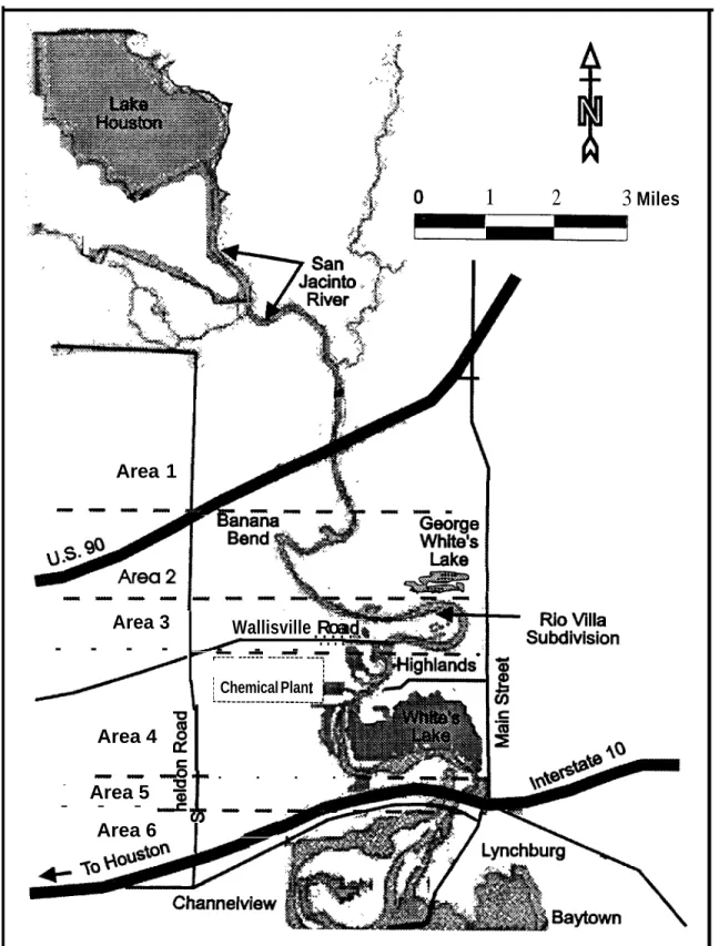
the riverbed and banks, destabilized roads and bridges, and inundated area homes. The largest new channel (approximately 510 feet wide and 15 feet deep) was created when the river cut through the Banana Bend oxbow4
just west of the Rio Villa Park subdivision. A second major channel cut through Banana Bend just north of the channel through the oxbow. Both these channels cut through areas where sand mining had been performed previously.
Beginning on October 16, 1994, weather forecasters began issuing flash flood warnings for the Houston area, and, on October 17, river flood warnings were issued for the San Jacinto and other area rivers. Heavy rainfall was expected to continue for several days.
The San Jacinto River, which normally flows at about 2.5 feet above sea level, crested at 28 feet above mean sea level on October 21. The peak discharge was more than 350,000 cubic feet per second, about 58 percent greater than the 100-year-flood. The highest velocity measured was 16.6 feet per second— approximately 11 miles per hour.
3
To wash or clear a riverbed by a swift current of water. 4
A U-shaped bend in a river.
PIPELINE FAILURES AND RESPONSE ACTIONS
,<. ..C <> ;$ :.. .
)
,..:. . . .
,. .,,q..
$’”
,::....:. .
,(
o
IMl
1 2 3 Miles 1I
SubdivisionRio VillaRemote-operated valves on both sides of the river crossing were closed to isolate the leak to within an 11-mile segment of the pipeline. By 7:30 p.m., Exxon personnel had closed a manual valve on the river’s east bank and isolated the leak to an 8-mile pipeline segment. By 7:45 p.m., Exxon personnel observed that the rate of product bubbling within the water had decreased, indicating to them that Exxon’s pipeline was the source of the LPG release.
Exxon crews worked through the night installing equipment to enable the company to release and burn the LPG in the isolated pipeline segment. They could not close the west bank manual valve because it was under water; however, in the evening of October 19, they closed a manual valve farther west of the crossing to isolate the leak to a 4-mile segment. Exxon crews visually inspected areas adjacent to its other pipeline crossings south of the Interstate 10 bridge and decided that they too could be threatened by the flood waters. At 8:15 p.m. on October 19, Exxon shut down pumps on its three additional operating pipelines—20-inch, crude oil; 10-pipelines—20-inch, refined petroleum products; and 8-inch, turbine fuel. Products in the pipeline segments crossing the river were then removed and the lines were purged using nitrogen. Once the lines had been purged, the manual valves nearest the river were closed, isolating those segments.
On October 20, Exxon notified the appropriate Federal, State, and local government agencies of the LPG pipeline failure, provided information on the actions it was taking to shut down and isolate all its pipeline crossings, and established a repair command center on the east bank of the river. Also on October 20, Exxon USA provided a spill response command center at its Baytown refinery for the use of the unified response team. (See upcoming section on Federal Management of the Spill Response.)
First Colonial Rupture -- Colonial Pipeline Company (Colonial) operates two pipelines— 40-inch and 36-inch—that cross the flood plain and the river at the oxbow just south of Banana Bend. Colonial shares a right-of-way in this area
with pipelines operated by Texaco Pipeline, Inc., (Texaco) and Valero Transmission L. P. (Valero). The pipeline right-of-way crosses the river about 4 miles north of the Interstate 10 bridge. The Rio Villa Park subdivision is located within the oxbow. Shallow sand pits, where a sand mining operation had been conducted several years earlier, lie to the west of the subdivision.
About 8:31 a.m. on October 20, the operator of Colonial’s Houston, Texas, pump station, (located about 12 miles west of the San Jacinto River) telephoned the controller at Colonial’s Atlanta, Georgia, control center. He advised the controller that the rate of flow in the 40-inch pipeline, which was transporting gasoline, had increased significantly. At 8:32 a.m., while the controller and the Houston operator were discussing the increased flow rate, an alarm came from the Shiloh pump station, located about 29 miles east of the San Jacinto River. The alarm told the controller that suction pressure in the line had fallen from normal pressures of about 40-50 psig6
to 23 psig.
The controller told the Houston operator to shut the 40-inch pipeline down. About 8:33 a.m., the operator did so. The operator also closed the Houston mainline pump station valve and valves to shipper locations. (Later, the mainline valve at the Shiloh pump station was closed.)
At this time, a shift supervisor who had been observing the activities of the controller for the 40-inch line initiated Colonial’s emergency response procedures. The shift supervisor advised the controller for Colonial’s 36-inch pipeline of the problems being experienced on the 40-inch line and cautioned the controller of the 36-inch pipeline to watch indications on that line closely. (The 36-inch pipeline segment between the Houston and Beaumont stations had been shut down at 11:06 p.m. on October 19, in
6
6
the course of normal pipeline operations, but the pipeline segment still contained low-sulfur diesel fuel under pressure.) The Houston operator dispatched Colonial personnel from Houston to the suspected rupture area to search for the site of any product release.
Gasoline flowed from the ruptured 40-inch Colonial pipeline into the swift-flowing flood waters and pooled in areas of slower water flow. Residents evacuating the Rio Villa Park subdivision reported that they detected the odor of gasoline about 9:00 a.m. on October 20 and observed oil and vapors south of Wallisville Road. A River Road resident on the south side of White’s Lake near Interstate 10 observed that gasoline fumes had collected near boathouses. At 9:37 a.m. (about 1 hour after the rupture), a Colonial employee performing an aerial patrol observed gasoline in a new channel that had been cut through the sand pit area of the oxbow.
About 9:40 a.m., a Colonial employee notified Harris County Sheriff’s Department officers located at the Interstate 10 San Jacinto bridge that Colonial’s pipeline had ruptured in the San Jacinto River. (The Interstate 10 San Jacinto bridge had been closed in both directions at 11:30 a.m. on October 18, when flood waters rose to the elevation of the approaches to the bridge.)
The Harris County Communications Center first learned of the gasoline release at 9:41 a.m., when a resident called 911 reporting an odor of gasoline from White's Lake in the River Road area. That call was transferred to the Channelview Fire Department, which advised the Communications Center that personnel at a chemical plant on the west bank of the river were checking for a possible leak at or near the plant. At 9:51 a.m., the Harris County Office of Emergency Management ordered the evacuation of Wallisville Road west of the river due to the strong fumes in the area.
Fire on the River
About 9:51 a.m., explosions and fires erupted on the river and began moving slowly southward towards the Interstate 10 bridge. Witnesses reported hearing a series of five distinct explosions and observing balls of fire and smoke rising just north of Interstate 10. After the first explosion, fire and smoke rose about 300–400 feet into the air. A second explosion, located about 200–300 feet to the west of the first, occurred about 10 seconds later, and a third explosion occurred about 600– 700 feet to the west of the second. Minutes later, two more explosions were heard as the fire advanced across the lake and the stream flow carried the petroleum toward the Interstate 10 bridge.
A Colonial supervisor conducting an aerial survey from a helicopter observed the ignition of the fire. He stated that he could see product spewing up from the ruptured pipeline and being carried downriver as far as the Interstate 10 bridge. He saw the fire flash above the product floating on the water. The fire appeared to him to have begun along the river’s eastern bank.
Harris County Emergency Response
The Harris County Sheriff’s Department District Commander stated that he observed a large black cloud and fireball to the northeast while he was crossing the (closed) Interstate 10 bridge about 10:15 a.m. He could not identify what was burning. He advised his dispatcher that a major event was underway, and he requested assistance.
In accordance with the Harris County Disaster Plan, the predesignated Sheriff’s Department Incident Commander was dispatched immediately to the scene, as were additional patrol units. Upon his arrival at 10:30 a.m., the Incident Commander requested county
mobile command vans7
to be dispatched, and he established a temporary command post about ¼ mile west of the bridge on the south side of Interstate 10. Several minutes later, a representative of Colonial identified himself to the Incident Commander and advised him that Colonial’s 40-inch pipeline had ruptured and was releasing gasoline. The Incident Commander requested that the Colonial representative stay at the command post to provide information.
About 10:50 a.m., Colonial advised the Harris County Command Center that it had closed valves at each side of the river on its 40-inch pipeline to isolate the rupture. It advised that the isolated pipeline segment contained 65,338 bbls8
(2.74 million gallons) of gasoline. Colonial employees had closed the manual valves nearest each side of the river; the west valve was closed at 9:59 a.m., and the east valve was closed at 10:13 a.m.
Second Colonial Rupture
About 11:30 a.m., Colonial’s shift supervisor told the controller of its 36-inch pipeline to close the remote-operated mainline valves between the Houston and Shiloh pump stations and all remote-operated valves on lines to shippers. (The controller later stated that he did not close the valves on either side of the San Jacinto River, as such action would have isolated the pipe segment crossing the river from the rest of the system and prevented him from monitoring the pressure in the pipe beneath the river, since pressure monitors were located only at the pump stations.)
About 1:00 p.m. on October 20, the Incident Commander extended the evacuation to all persons within 9 miles of the failed 40-inch Colonial pipeline.
7
Harris County provided 2 mobile command vans, 69 patrol units, and 2 boats.
8
Barrels. Barrel capacity is 42 U.S. gallons.
Colonial's 36-inch petroleum pipeline ruptured about 2:00 p.m. The Colonial shift supervisor directed that personnel travel to and close the manual valves at the river crossing and that the failure be reported to local officials. About 2:30 p.m., the line failure was reported to the Incident Commander by Colonial.
About 2:45 p.m., the Incident Commander requested the Channelview Fire Department to call DIGTESS, a local pipeline one-call notification system,9
to obtain a listing of companies that operated pipelines adjacent to the river that might be affected by the flooding. He learned from the Colonial representative that the mainline valves on Colonial’s failed 36-inch pipeline had been closed at Pasadena and Trinity, Texas, isolating the failure to a 30-mile-long segment of the pipeline (containing about 196,000 bbls or 8.2 million gallons of petroleum). By 3:00 p.m., representatives of many local and State agencies arrived at the Interstate 10 command post.
At 6:30 p.m., the Texas Railroad Commission, the agency responsible for safety oversight of intrastate pipeline operations, reported to the Incident Commander that 25 operators of pipelines north of the Interstate 10 bridge had shut down operations and secured their pipelines under pressure. At 8:00 p.m., in the belief that the situation was safe, the Harris County Office of Emergency Management advised flood evacuees that they could return to their homes. However, a health advisory was issued for all persons to stay indoors until further notice due to the air quality. During the night, the Texas Department of Public Safety monitored U.S. Route 90 for driver visibility and placed lighted caution signs on both of the U.S. Route 90 bridges. Throughout the night, the Harris County Sheriff's Department
9
There are three one-call systems in the State of Texas: DIGTESS, LONESTAR, and TEXAS. Pipeline operators must register with at least one of these systems so that the utility companies can be notified of planned excavations and mark the location of buried pipelines prior to excavation.
8
monitored a barge burning on the river, the size of the spill, and the highway traffic. In addition, it maintained security for residences in the flooded and evacuated areas.
Texaco and Valero Ruptures
About 10:30 a.m. on October 20, the operators of the Texaco and Valero pipelines had learned through news media reports that a Colonial pipeline had apparently ruptured at the river. At 3:45 p.m., Valero’s 12-inch natural gas pipeline ruptured.
Texaco had shut its 20-inch pipeline down the previous August, leaving crude oil in the pipe under no pressure. Consequently, Texaco was unable to monitor this pipeline to detect a leak or rupture. Texaco considered repressurizing the pipeline, but eventually rejected this idea because if a leak existed, repressurizing the line would cause the release of more oil. Texaco also considered the options of using nitrogen or water to displace the crude oil from the pipe segment, and cutting into its pipe (tapping) to draw oil from the pipe segment in the flooded area. Of all available options, Texaco determined that the latter action provided the least uncertainty.
Texaco employees were dispatched to close manual valves east of the river. After the valves were closed, Texaco operated pumps at its East Houston Station to draw as much product as possible from the pipeline crossing the river. Texaco could remove only 260 bbls of crude oil at that time. About 6:30 p.m. on October 20, a Texaco representative conducted an aerial patrol of the pipeline and observed crude oil leaking. During a second aerial survey on October 21, a Texaco representative observed what he believed was crude oil on the water near Texaco’s pipeline right-of-way. Texaco assumed that the leaking crude oil came from its own pipeline. Texaco activated a district emergency response team to begin its spill recovery response.
About 2:00 p.m., Texaco dispatched employees to both sides of the San Jacinto River to cut into the pipe and remove as much product as possible. About 3:00 p.m., Texaco notified local, State, and Federal agencies that its pipeline had likely ruptured at an undetermined time and that it was taking response actions, which it detailed.
By 1:20 a.m. on October 22, the pipe on both sides of the river was tapped. Using vacuum trucks, Texaco personnel applied suction to the line at both ends of the crossing, resulting in the recovery of 40 bbls and 370 bbls of crude oil from the west and east ends of the line, respectively.
Federal Management of the Spill
Response
National Response System Structure -- The National Response System (NRS) is a national mechanism for coordinating response actions by all levels of government in support of an On-Scene Coordinator (OSC) when discharges of oil and releases of hazardous substances, pollutants, and contaminants occur. The National Response Team (NRT) of the NRS is responsible for providing national planning and coordination for responding to such emergencies.
The NRT consists of representatives from the Environmental Protection Agency (EPA)— which serves as its chairman, the Coast Guard— which serves as its vice chairman, the Federal Emergency Management Administration (FEMA), the Nuclear Regulatory Commission, the General Services Administration, the U.S. Public Health Service, and the U.S. Departments of Defense (through the U.S. Corps of Engineers and U.S. Navy Supervisor of Salvage), Energy, Commerce (through the National Oceanic and Atmospheric Administration), Interior, Justice, Labor, and Transportation.
Among its other responsibilities, the NRT must evaluate methods of responding to discharges or releases; recommend to the EPA Administrator changes needed in response organizations and the National Contingency Plan (which appears in Section 105 of the Comprehensive Environmental Response Compensation and Liability Act of 1980, 42 United States Code 9605, as amended); provide policy and program direction to Regional Response Teams; make recommendations to appropriate agencies as to training, equipping, and protecting response teams; and direct organization planning and preparedness.
As the functional arms of the NRS structure, the Regional Response Teams (RRTs) are responsible for the planning and coordination of preparedness and response actions. RRT membership parallels the NRT’s, but also includes State and local representation. Each RRT provides appropriate regional mechanisms for developing and coordinating preparedness activities before a response is undertaken, coordinating assistance and advice to the OSC during responses, and providing advice to area committees to ensure consistency of area contingency plans with the National Contingency Plan. An RRT may be activated, at the request of the OSC, during any discharge situation. Texas is within the jurisdiction of Federal RRT Region VI.
Lead Agency and Management Structure – In the case of the San Jacinto product release situation, the liquid products being released north of the Interstate 10 bridge were in an area for which the EPA has spill response management responsibility. However, the products flowed south and contaminated the coastal zone south of the Interstate 10 bridge, an area for which the Coast Guard has spill response management responsibility.
About 10:00 p.m. on October 20, representatives of the Coast Guard, the EPA, and other concerned agencies met to discuss the management of the oil spill recovery actions. While both the Coast Guard and the EPA had personnel qualified to serve as a Federal On-Scene Coordinator (FOSC), the agencies decided that the Coast Guard would be the lead agency in a unified Federal response10
to manage the spill cleanup. This decision was made primarily because the Coast Guard had a significantly larger presence in the area and had already established effective communications with local and State authorities during its response to the flood emergency.
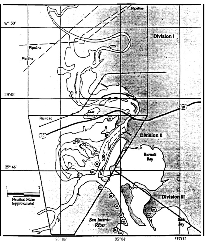
The Coast Guard FOSC stated that he established a unified command/incident command system to ensure that his decisionmaking included the knowledge, experience, and concerns of the Texas General Land Office (TGLO), as the representative for State and local agencies, and of the two pipeline companies whose products were the focus of the cleanup. (See figure 3.)
The unified command’s Planning Section, managed by a Coast Guard officer, was responsible for researching issues and developing plans on activities that might later be implemented. The Operations Section, managed by a Coast Guard Reserve officer, was responsible for handling current activities, such as the placement of booms and product recovery equipment.
The Operations Section had five divisions within its Cleanup Branch, each managed by Coast Guard personnel. Division I included Banana Bend and the adjacent oxbow meander.
10
See Incident Command Technical Assistance Document: Managing Responses to Oil Discharges and Hazardous Substance Releases Under the National Contingency Plan.
10
(See figure 4 for areas under Divisions I through III authority.)
The FOSC held meetings each morning and evening, at which time he and others were briefed on the activities taken, planned, or under consideration.
Operations –
General
.
One of the first actions of the FOSC on October 20 was to ask the Texas Railroad Commission to identify and secure all pipelines along the San Jacinto River as far north as Lake Houston. The FOSC also requested all operators of water systems south of the Lake Houston Dam to close and secure their water intakes. He directed the Vessel Traffic Control System to close the Houston Ship Channel to all but emergency vessels. In addition, the Texas Railroad Commission suspended all railroad traffic crossing the San Jacinto River. Throughout the morning of October 21, petroleum products from severalpipelines, as well as a barge, were on fire on the river. (See figure 5.)
About 9:00 a.m. on October 22, the Coast Guard’s unified command center advised the Harris County Sheriff’s Department that high levels of jet fuel vapors were being detected in the River Bend area near Wallisville Road, and directed evacuation of the area. The Channelview Fire Department began to evacuate the affected area, but about 1:00 p.m., the Coast Guard advised the Sheriff that the earlier readings had been in error, so the evacuation order was lifted.
Several isolated small fires were burning on October 23 where Colonial’s and Texaco’s pipes on the east bank of the new channel were releasing crude oil and diesel fuel, and where Colonial’s and Texaco’s ruptured pipes at the west channel bank were releasing diesel fuel, crude oil, and some gasoline.
Figure 3 – Unified command management structure
Texas General Land Office Colonial PL
Safety Liaison
Information
Emergency Ops Branch
OPS/NOAA/TGLO/ NRC/Pipelines
Division I Division II Division III Division IV Division V
Cleanup Branch
Operations Planning Logistics Finance
San Jacinto
River
Spill
Waste Tracking Map (1) Date/Time: 24 OCT 94,2100
Platform
preparedby NOAA
Observers:
USE ONLY ASA GENERAL REFERENCE Graphic does not show precise locations oramounts of waste
I Al /. ,., ::.:<: w“ 50’ I
“R’?> ‘
29’48’I
o L 95’ 06’ 95”04’ 95" 02'of pollution, although some fuel escaping the fire was contaminating the beaches; and
• Means were being considered to minimize further environmental damage by enhancing ongoing burning or initiating in-situ burning of oil currently escaping or that might escape from future ruptures.
The draft listed items to consider based on the approved in-situ controlled checklist developed by RRT VI and RRT Alaska, and included a discussion on the pros and cons of conducting an in-situ controlled burn.12
That draft document concluded that enhancing ongoing in-situ burning or initiating in-situ burning of the products released would be more desirable than using mechanical recovery or dispersant techniques. The draft stated that the purpose of in-situ controlled burning is to:
Reduce the overall duration and effort invested in the cleanup operation.
It stated that an in-situ controlled burn might pose risks to personnel and cautioned that:
In-situ controlled burning operations should not commence until an operation safety plan is prepared. It should address personal safety, firefighting, ignition hazard, evacuation, and other aspects needed in order to protect personnel conducting the burn. The possible impact of the smoke plume should be assessed. If needed, the public should be notified and the possibility of evacuation should be considered.
12
The RRT VI In-situ Burn Plan stated that near-shore, inshore, or onshore burns are not addressed within the response plan. The RRT VI In-situ Burn Plan also emphasized the requirement to monitor air pollution as a means by which to gauge and control the boom effectiveness, and the importance of being able to extinguish the fire at any time by releasing the boom.
The paper listed pros and cons of in-situ burning of oil as:
Pro
• In-situ burning should minimize the environmental damage of the spilled oil by burning the oil at the source of the spill;
• In-situ burning should reduce the amount of toxic, volatile compounds emitted from the oil by burning them at the source;
• In-situ burning should reduce the overall duration and effort invested in the cleanup operation and minimize the risk of personnel injury associated with this effort.
Con
• In-situ burning may temporarily increase the level of air pollution, especially the concentration of PM-10 (small soot particulates that can be inhaled);
• In-situ burning may pose risks to personnel conducting the burning;
• In-situ burning requires specialized equipment not readily available.
Operations Section Activities
. In-Situ Burn Plan. A short time after the FOSC completed his October 23 morning status meeting, the TGLO representative developed and presented to the Operations Section chief a handwritten proposal not discussed in the meeting. The proposal, dated October 23, 1994, was entitled Burn Enhancement Proposal and called for deployment of 500 feet of fire boom13 just south of (Texaco’s) 20-inch ruptured13
A fire boom is a floating containment device constructed of fire-resistant materials and used to capture and contain petroleum (or other flammable materials to be burned) on the water surface.
14
pipeline at the east channel bank “...as close/far as safety considerations allow.” (See figure 6.)
The fire boom was to be anchored to the east channel bank and have an opening of about 100 to 150 feet. The proposal stated that the objective was to:
…contain and remove, by the burning process, additional unburned crude/oil at the pipe (20”) rupture site. Operation to be conducted as outlined and sketched below with Coast Guard on-site oversight. The schedule called for the action to be taken between 10:00 a.m. and noon of that day (October 23). The TGLO was to supply the fire boom, Oil Mop, Inc., was to be the contractor to carry out the work, and the Coast Guard was to have oversight responsibility. No provisions were included to provide air monitoring, notice to local response agencies, alternate action (should the planned timeframe not be met), or a site safety plan covering the safety of fire boom crews.
Plan Approval. The FOSC and the TGLO representative reviewed and, by affixing their signatures to the draft, approved implementation of the in-situ burn plan. Next, the Operations Section chief and a second TGLO representative performed an aerial evaluation of the new channel to determine if the proposed position of the fire boom was practical. Based on their aerial observations, they agreed that the approved plan was feasible. Among other information, Colonial’s noon status report to the unified command center stated:
Colonial crews working on west side of the river will be using a National Response Center barge (currently being assembled at Lyondell [Petrochemical Company]) for the purpose of ferrying equipment across the new channel to the
island. The barge will be available for service at 2:00 p.m.
Our surveillance info indicates that a single fire remains on the east side of the new channel. It also indicates that all four lines crossing the channel are completely severed.
Our local personnel have the understanding that the Coast Guard will be deploying a boom for the purpose of containing and recovering crude oil and fuel oil leaching from the Texaco and Colonial line on the west side.
Plan Implementation. The Coast Guard’s Operations Division I supervisor was told that the EPA OSC would visit the equipment staging area to pick up 500 feet of fire boom. He was not told of any plan or proposal for using the fire boom. While he was aware that the EPA OSC was on the scene to handle the recovery of hazardous materials containers, he was not aware that the EPA OSC was conducting petroleum product recovery activities in Division I.
Instead of the EPA OSC picking up the fire boom, the TGLO arranged for the boom to be picked up and transported to an area near the channel. When the fire boom was delivered, the EPA OSC, his EPA contract assistance team, and the two Coast Guard personnel with them completed the placement of conventional booms in the new channel, several hundred feet downstream of the ruptured pipelines, to divert petroleum products for future collection. About 2:00 p.m., after deploying the conventional booms, the EPA OSC and his workcrew returned to their equipment staging area, where the EPA OSC was told that a fire boom had been delivered and that he was to call the unified command center for instructions.
16
The EPA OSC telephoned the unified command center as directed. His call was answered by the Planning Section chief, who was in the Command Room. The EPA OSC asked if a plan had been approved for deploying the fire boom. Without consulting anyone in the Operations Section, the Planning Section chief went to the Operations Section, found a copy of the plan approved by the FOSC and the TGLO, and read the plan notations to the EPA OSC. He instructed the EPA OSC to call the unified command center again when the boom had been deployed.
The EPA OSC and his EPA contract team supervisor discussed the plan for the in-situ burn. Both stated that they were concerned about carrying out an in-situ burn in the channel because of the quantity and volatility of petroleum products in the area, and because they had not had the usual opportunity to discuss plan details and safety precautions with those who had developed and approved the plan. They, with the two Coast Guard strike team personnel accompanying them, discussed how and where to best deploy the fire boom. The southern end of the new channel had two outlets into the main river, forming an island between them. They decided to place a conventional boom near Wallisville Road across the west channel outlet, as this channel was not flowing as rapidly as the east outlet. The fire boom was then to be placed across the east outlet, about 500 yards south of the pipeline breaks, where they believed it would be safe to operate their boat engine.
Meanwhile, after noon on October 23, the Operations Section chief and the second TGLO representative made a second aerial observation of the channel. During that trip, the Operations Section chief observed that the water level in the channel had dropped drastically and that the west outlet no longer appeared to be flowing. Based on this observation, the Operations Section chief advised the TGLO representative that the petroleum products could be removed by mechanical means and that the Burn Enhancement Plan should be canceled. When the Operations Section chief returned to the
command center, however, he did not inform either the FOSC or the Division I supervisor of the decision to cancel the in-situ burn, nor did he determine what, if any, action had been initiated to implement the plan.
About 3:00 p.m., the EPA OSC and the EPA contract crew began deploying additional booms in the channel outlets. Highly volatile products were in the area where they were installing the fire boom. Some areas reportedly contained up to 10 inches of petroleum products on top of the water. The EPA OSC estimated that, when fully deployed, the fire boom was holding back more than 2,800 bbls of a low flashpoint mixture of oil, gasoline, and diesel fuel.
After placing the fire booms, the EPA OSC sent most of the contract workers back to the staging area. Two EPA contract employees and one Coast Guard strike team member were left on the east bank of the channel outlet to anchor the end of the fire boom. The EPA OSC told them to await his radio instructions. The EPA OSC, the EPA contract supervisor, and the other Coast Guard strike team member then flew by helicopter to the west bank of the new channel to warn Colonial and Texaco workcrews about the pending in-situ controlled burn. The three-person joint Coast Guard and contractor crew that remained on the east channel outlet bank checked nearby areas for people in potentially dangerous sites. They found several persons in the Rio Villa Park subdivision and told them to leave the area.
From the west bank of the new channel, Colonial’s on-site safety coordinator watched the helicopter land and the EPA OSC get out. The EPA OSC told him that the Coast Guard had approved in-situ controlled burning of the accumulated product at the pipeline openings. The EPA OSC advised that this type of burning was a routine procedure for the disposition of accumulated product. The Colonial safety coordinator told the EPA OSC that ignition of the product should be delayed until the Texaco crews finished closing the end of their pipeline,
the Colonial work crews in the area could be alerted, and the operator of a small boat (later identified as a Coast Guard patrol boat) on the river could be alerted and evacuated.
In-Situ Burn. One of the EPA contract employees left on the east side of the fire boom stated that while the EPA OSC and the Colonial safety coordinator were on the west bank of the new channel discussing the proposed in-situ controlled burn, he and the others heard the question “What are you waiting for?,” over the EPA contractor’s mobile radio. The EPA contract employee stated that the east bank team believed that the question signaled them to ignite the accumulated petroleum products. He stated that he tried three times unsuccessfully to make radio contact to confirm that the product should be ignited. Then, the three employees on the east bank agreed that they had been signaled to ignite the accumulated products. Flares were lit, placed on a trashcan lid, and floated into the area of accumulated petroleum products adjacent to the fire boom.
The EPA contract supervisor who went to the west side of the channel later stated that he heard no radio transmissions from any of the three personnel left on the east bank. The Colonial representative stated that as he and the EPA OSC were talking, the EPA OSC made no radio communications until the flames were seen coming from the east bank towards them.
At 6:03 p.m., the products ignited and rapidly flashed across the channel and shoreline south of the channel. One of the three persons on the east side of the boom announced over the radio that the products had been lit.
The EPA OSC recounted that, about 6:00 p.m., after warning the Colonial representative of the planned in-situ burn, he heard a transmission on his EPA contractor radio reporting that the fire had been lit. He looked to the southeast and saw the flames traveling towards him. The EPA OSC and others who had gotten out of the helicopter on the west bank ran from the oncoming flames while the pilot flew the helicopter to safety and announced over its
public address speaker that all persons in the area should evacuate. All of the people at the work site ran from the oncoming flames. The resulting fire sent flames about 100 feet into the air. The smoke plume rose about 1,500 feet vertically and, when it came into contact with an inversion layer, the smoke traveled horizontally. According to the Colonial representative, the fire never approached any of the site workers, and the Texaco employees returned to complete their work about 15 minutes later. Afterwards, all pipeline employees left the area. No injuries resulted from this in-situ burn.
Minutes after 6:00 p.m., the Coast Guard operations center received a report of the eruption of a large fire on the river from unknown causes. More than an hour afterwards, the unified command center learned that the fire had been the result of a deliberately initiated in-situ burn. The FOSC stated that he had not been aware of any approval given to ignite the accumulated product, and that he had understood that he was to have been consulted before the product was ignited. He stated that it had been his intent, once he had been advised that everything was ready and atmospheric conditions were favorable, to alert both local government and private interests of the intended burn. He expressed no knowledge of his Operations Section chief deciding against implementing the Burn Enhancement Plan.
By 9:00 p.m. on October 23, the height of the flames from the in-situ fire had reduced to 60 feet. By 6:00 a.m. the next day, the fire was moving south, away from the new channel. The Coast Guard monitored the progress of the fire, and the EPA assessed the airborne pollution threat until the fire self-extinguished about 10:00 p.m. on October 24.
18
Injuries
Residents Employees Others Total
Fatal 0 0 0 0
Serious 1 1 0 2
Minor 544 1 0 545
Total 545 2 0 547
Medical and Pathological
On its Office of Pipeline Safety (OPS)14 incident report for the gasoline release, Colonial recorded that 925 persons had been injured. On its report for the diesel fuel release, Colonial reported that 926 persons had been injured. However, the Safety Board’s investigation indicated that a total of 547 persons were treated at 4 local hospitals, primarily for smoke and vapor inhalation complaints.
Two of the injured were residents of River Road, who sustained burn injuries while returning to their residences. A 64-year-old woman sustained serious second- and third-degree burns over 18 percent of her body; face, arms, ankles, and legs. A 65-year-old man sustained minor first-degree burns to his arms. Two pipeline workers were injured on October 27, during the removal of the damaged Valero pipe. One sustained a contusion to his right leg and the other sustained a serious injury, a fractured left jaw.
Damages
In addition to the damage to buildings and equipment caused by flooding, the Harris County Fire Marshal estimated that the petroleum fire heavily damaged at least four houses, six mobile homes, one commercial building, nine automobiles, eight boats, and four
14
The OPS is a part of the Research and Special Programs Administration of the U.S. Department of Transportation. The OPS is responsible for administering the Federal pipeline safety program.
houseboats. Colonial reported that it had received about 3,000 reimbursement claims for fire damages, soot deposits, and temporary housing. Spill response costs were in excess of $7 million. In addition, pipeline operators reported product losses of more than 35,000 bbls and property damage losses of about $16 million.
Although a total of 37 pipelines were ruptured or undermined during the flood, the incident reports filed with the OPS covered only 5 of the 8 ruptured pipelines; those operated by Colonial (2), Exxon, Texaco, and Valero.15
Of the other three pipelines that ruptured, one had been taken out of service and purged of crude oil by Citgo Pipeline Company in August 1994. The other two pipelines had been taken out of service and purged of crude oil and turbine fuel by Exxon during the evening of October 19.
Colonial reported property damage losses of $10 million and product losses of 20,000 bbls of gasoline resulting from its 40-inch pipeline failure. Colonial reported property damage losses of $0 and product losses of 10,000 bbls of gasoline from its 36-inch pipeline failure. Exxon reported property damage losses of $610,000 and product losses of 492 bbls of LPG. Valero reported property damage losses of $800,000 and product losses of 7,000 million cubic feet of natural gas. Texaco estimated that it suffered about $4.5 million in property damages and lost 5,350 bbls of crude oil.
15
While the failure of at least three pipeline operators to file reports with the OPS raises some questions as to the seriousness with which pipeline operators view this filing responsibility, it should be noted that a number of factors, including the operators’ differing means of gauging the value of their losses, may have persuaded some operators that they were not legally obligated to file in this instance.
Emergency Organization and
Participation
The Oil Pollution Act of 1990 (OPA 90; Public Law 101-380) and the National Oil and Hazardous Substances Pollution Contingency Plan require establishment of RRTs to plan and coordinate regional preparedness and response actions, including procedures and techniques to be employed in identifying, containing, dispersing, and removing oil. In this incident, RRT VI’s involvement was limited to approval of the in-situ burn plan.
The primary mechanism or plan governing the environmental response activities in the region of this accident is the Galveston Bay Area Contingency Plan. The plan was approved in 1994 by the Captains of the Ports for the Galveston and Houston Coast Guard commands. The contingency plan is designed to handle emergency responses to releases of petroleum products and to establish the Coast Guard’s Captain of the Port as the FOSC for managing the
activities of Federal, State, and local emergency response agencies.
The local fire and medical responses were coordinated by the Channelview and Highland Fire Departments. Approximately 12 mobile intensive care units and advanced life support ambulances were used to transport injured patients to local hospitals. The fire departments responded to structural fire alarms but made no attempt to extinguish on-river petroleum fires.
Local area response organizations and officers included the Houston Fire Department Hazardous Materials Team and Fire Marshal, the Channelview Volunteer Fire Department, the Highland Fire Department, and the Harris County Pollution Control and Office of Emergency Management. Medical command posts were established near Interstate 10, and the Sheldon and Redbud Roads.
The following agencies were involved in the unified command center response:
ORGANIZATION RESPONSIBILITY
U.S. Coast Guard Oil spill cleanup and environmental restoration
Texas General Land Office Oil spill cleanup and environmental restoration
U.S. Army Corps of Engineers Channel and river obstructions
Texas Natural Resource Conservation Commission Oil spill and hazardous material response National Oceanic and Atmospheric Administration Scientific support and shoreline assessment U.S. Environmental Protection Agency Inland oil spill and environmental
restoration/air and water sampling U.S. Department of Transportation,
Office of Pipeline Safety
Federal pipeline safety
Railroad Commission of Texas State pipeline safety Texaco Pipeline, Inc. Information and assistance Colonial Pipeline, Inc. Information and assistance
20
The Coast Guard managed the cleanup efforts, which involved laying booms downstream of the area where the pipelines ruptured to protect sensitive areas and deflect and collect the liquids released from the pipelines. Oil deflected to narrow areas in the river and gathered within booms was retrieved from the water surface using skimmers or vacuum trucks.
The EPA managed air quality monitoring through October 26 and obtained and analyzed numerous water and soil samples. The EPA found that the contaminants released during the event did not pose a health risk to the public.
Disaster Preparedness
The Coast Guard’s Houston command last held a drill to test the area’s emergency organization capabilities and preparedness for responding to a major spill with fire during severe weather on February 10, 1994.16
Many of the scenarios (including in-situ burning) tested during that exercise occurred during the response to the October 1994 flood. The February exercise included use of an in-situ controlled burn protocol. The April 29, 1994, critique on the February exercise reported:
Performance
Planning section personnel were slow in advancing the in-situ burn application. This was caused by considerable internal debate over “required” information for RRT in-situ burn application submission and by diverting technical resources to evaluate the dispersant option.
The Area Contingency Plan should recognize the possibility that FOSC may want to consider processing simultaneous response tool applications to RRT for approval (in-situ, dispersants, etc.).
16
A similar table-top exercise was planned to be conducted in the Houston area on November 5, 1994, and would have included most of the agencies that responded to the October 1994 emergency.
Guidance should be included to the Area Contingency Plan to handle simultaneous/multiple response tool applications to RRT (that is, division of labor, two review teams, etc.).
Enhancements
The in-situ burn checklist needs to be incorporated into the Area Contingency Plan. It’s essential that the RRT identify what information to be provided in the checklist is “required” or “supplemental” to support a decision by the RRT. Use the Area Contingency Plan to prioritize application work based on acceptable response techniques within a specific geographic area. Encourage area committee members to explore preapproval response options.
The Harris County Disaster Plan was approved by the Texas Department of Public Safety on August 10, 1994, as meeting all applicable State and Federal requirements. The last Harris County disaster drill was conducted in May 1994. It simulated a natural disaster. The disaster plan was activated on October 17, in response to the flooding, and stayed in effect until the fires were extinguished on October 24. Hazardous materials training simulations had been conducted by the Harris County Office of Emergency Management in September and November 1993 and in April 1994.
One of the problems that the Harris County public safety officials identified during this accident was the need for improved emergency communication links between Harris County, the Coast Guard, and the TGLO. They recommended that a universal emergency radio band frequency be used on-scene to improve communications.
In-Situ Controlled Burning Approvals
As already stated, Texas is within the jurisdiction of RRT VI. Policies governing Region VI operations grant preapprovals for in-situ controlled burning of spills that are 3 miles or farther offshore and require that specific approval be obtained for all other proposed in-situ controlled burning. To obtain approval for an in-situ controlled burn, the Galveston Bay Area Contingency Plan (which was the plan controlling the response actions of the unified command during the October 1994 cleanup activities in Texas) requires that the FOSC consult with the Texas Air Control Board on all requests regarding in-situ controlled burns. The purpose of consultation is to provide the Air Control Board opportunity to consider potential hazards of a proposed burn based on its location relative to populated areas and on the likely harm it might do to air quality, given the expected wind speed and direction, atmospheric conditions, and other factors at the time of the proposed burn.The in-situ controlled burn plan developed by the Region VI RRT preapproves the use of in-situ burning in offshore Gulf Coast areas by a FOSC under specified conditions, but it does not address in-situ controlled burning for near-shore, innear-shore, or onshore areas. However, it cautions that if :
A deliberate burn were planned for near-shore areas, along a near-shoreline or riverbank, in a marsh, or onshore, the potential for secondary fires would have to be considered very carefully. The proximity of ignitable vegetation, trees, docks, and other facilities would need to be examined with respect to the initial movement of vapors (prior to ignition) and the potential movement of burning oil.
Although the plan was not applicable to in-situ controlled burns in near-shore areas, it contained (in its appendix) a checklist of information that should be considered before carrying out an in-situ controlled burn. The
eight-page list included numerous weather and other factors that should be considered before performing an in-situ controlled burn, and recommended product-specific safety equipment and procedures. The last item in the list (page A-8) was a note stating that:
If the FOSC approves of in-situ burning, local media and residents in areas within the potential smoke plume trajectory must be notified prior to initiating the burn.
Spill Response Overview
After the emergency, when the FOSC was reflecting on the events of October 23, he stated that it had become apparent to him that the policy of enhancing ongoing fires had drifted into an in-situ burn procedure without the emergency managers recognizing the transition and its ramifications. Consequently, they did not follow established in-situ controlled burn procedures. They did not develop a safety plan, put required safety controls in place, evaluate the need to evacuate adjacent residents (even though residents had been allowed to return to their homes on the morning of the burn), or give notice about the in-situ burn to local governments and private companies taking part in the response.
Immediately following this incident, neither the Coast Guard nor the EPA conducted an in-depth, comprehensive critique of the response operations to learn why established procedures were not followed relative to the in-situ burn, or to review other problems experienced. The Coast Guard and several other organizations conducted individual assessments of their activities, but no overall critique was carried out to obtain the collective feedback of the EPA, local governments, private companies, contractor groups, etc.
The FOSC stated that, because no one was injured and the burn was technically effective and the “right thing to do,” he did not aggressively pursue the matter. His only
22
explanation for the errors made relative to the in-situ burn was that all emergency personnel had been working 18-22 hour shifts since the flood began and that mistakes are far more likely to be made under such conditions. Overall, he believed that operations had been effective, and that few mistakes had been made during the response.
In his March 9, 1995, memorandum to the Coast Guard Commandant on lessons learned from the San Jacinto River response, the FOSC characterized the response effort as “extraordinarily successful” and provided the “lessons learned” based on comments from the various Coast Guard groups17
that participated in the response. Among the recommendations made in response to the lessons learned, he included:
The Commandant should specify use of a standard skeletal incident command organization nationwide to facilitate transitions from local to larger response organizations when organizational personnel are brought in from outside the area and from industry. It was found that some personnel brought in were familiar with the Incident Command System as defined in the Area Contingency Plan while others were not and the differences in command system knowledge create a degree of confusion.
17
The Coast Guard commands that participated in the response critique were the Marine Safety Office Houston; the Marine Safety Office Galveston; the Vessel Traffic Service Houston-Galveston, Group Galveston; the U.S. Coast Guard Cutter CLAMP; and the U.S. Coast Guard Cutter HATCHET.
(See appendix A for additional material regarding the lessons learned.)
Although the Coast Guard brought many of its commands together to critique the events of October 1994, it did not include all that participated in the response, nor all personnel who had served in management response positions. Specifically, the Pacific, Gulf, and Atlantic Strike Teams, and the Operations Section chief and Operations Division I supervisor did not participate.
On August 1, 1995, the EPA’s contracted Technical Assistance Team issued its report on the “controlled burn” of October 24 (the actual date was October 23). The report stated that the burn was performed to eliminate a large pool of oil wastes and flood debris near the burned pipelines and the Rio Villa Park subdivision that was not accessible except by using a small boat. It stated that the EPA OSC requested and received permission from the FOSC to conduct an in-situ burn, and that about 7:00 p.m. (actual time was about 6:00 p.m.), the in-situ burn was initiated. The EPA reported that the burn lasted about 2 hours (actual duration was about 28 hours), was monitored throughout, self-extinguished, and affected about 0.25 acre (actually more than 15 acres). The report repeated that the event was an approved in-situ burn and acknowledged that it had not been publicly announced.
The Coast Guard, in conjunction with the Research and Special Programs Administration (RSPA), conducted an Incident Specific Preparedness Review of the response to the October 1994 petroleum spills in the San Jacinto River. The report of the review was issued on July 30, 1996. It identified many aspects of the response that had been successful, such as making effective use of the unified command management process, and other features that required improvement, such as the need for the Coast Guard to have a common response management system. However, the Coast Guard review, like those conducted by the FOSC and
the EPA Technical Assistance Team, did not include among those persons interviewed all who had served in key response management positions. For example, the Operations and Planning Section Chiefs—two of the Coast Guard personnel who knew most about the October 23 in-situ burn—were not interviewed. Also not interviewed were the Division I leader, the TGLO representative who had initiated the in-situ burn proposal, the EPA OSC, and management personnel from the companies that had been contracted to assist in conducting the burn.
24
The River Basin
18Stream Behavior -- The San Jacinto River, located just east of Houston, Texas, is a meandering, alluvial stream with a flood plain extending from the river eastward approximately 2 miles and westward approximately ¾ mile. With time, alluvial stream system banks will erode, sediments will be deposited, and flood plains, islands, and side channels will undergo modification. Alluvial channels continually change position and shape due to the water flow exerted on the streambed and banks. These changes may be gradual or rapid, and may result from natural causes or human activities.
The behavior of a stream at a specific location depends not only on the stability of the stream at that location, but on the stream system of which it is a part. Upstream and downstream changes may affect the future stability of a site. Natural disturbances, such as floods, droughts, earthquakes, forest fires, etc., may result in large changes in the quantity of sediment moved by a stream and thereby cause major changes in the stream channel. Such changes can be reflected in the buildup or reduction of a streambed due to sediment disposition or scouring, respectively. They also can be reflected in the lateral migration of the stream channel.
Human-made changes in the drainage basin and the stream channel, such as alteration of vegetation cover and construction of bridges and
18
Information on stream characteristics, behavior, and stability was compiled from Stream Stability at Highway Structures, U.S. Department of Transportation, Federal Highway Administration Publication No. FHWA-IP-90-014, Hydraulic Engineering Circular No. 20, February 1991.
other structures, can alter the hydrology of a stream, its transportation of sediment, and its channel geometry. Such changes will affect the magnitude, frequency, and other characteristics of future floods.
Changes in channel geometry over time are particularly significant during periods when alluvial channels are subjected to high water. Erosive forces during periods of high water flow may have a capacity as much as 100 times greater than those acting during periods of intermediate or low flow. The full-channel flow rate in many natural channels generally occurs about every 1.5 years, during which about 90 percent of all changes in channel geometry occur.
Alluvial channels deviate from a straight alignment, causing the deepest portion of the channel to oscillate transversely. This behavior forms bends in the stream. When the current is directed toward a bank, the bank is eroded in that area, and the current is deflected and impinges on the opposite bank farther downstream. Scour in the bend causes the bank to migrate farther downstream and sometimes laterally.
As a meandering stream system moves laterally and longitudinally, meander loops move at unequal rates because the differing compositions of the banks result in differing erosion rates. Channel sections appear as slowly developing bulb forms. On highly meandering streams, elongated, bulb-shaped loops are likely to form with the narrowest land area (neck) gradually eroding until the stream cuts directly across it. The cutoff meander loop, no longer a part of the active stream channel, becomes an oxbow lake. Oxbow lakes are indicative of meandering streams but are not necessarily
SUPPLEMENTARY INFORMATION
indicative of the channel migration rate. The cutoff of a meander loop causes a local increase in the channel slope and a more rapid growth rate of adjoining meanders. When engineers are designing structures across streams, information about the probable way the loop will migrate or develop, as well as its likely growth rate, would be useful.
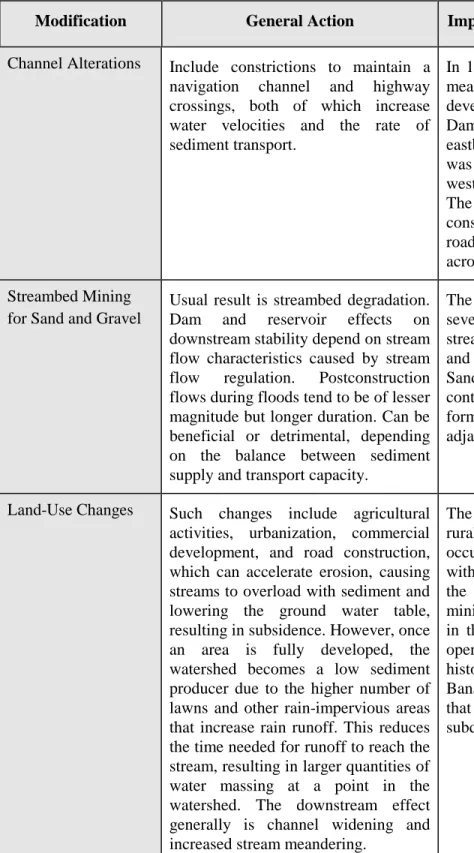
Stream Stability -- The stability of a stream is dependent on a number of interrelated variables, including natural or imposed changes in a stream system, evolution of stream channel patterns, channel geometry, and watershed hydrology. Human activities can produce major changes in stream characteristics locally and throughout the stream system. All too frequently, the net result of stream “improvement” is departure from stream equilibrium. Human activities are a major cause of changes to streambeds. The most common human-caused activities that result in streambed changes are channel alteration, streambed mining, construction of dams and reservoirs, and land-use changes.
Table 1 (see next page) lists the effects of some common activities, as well as activities in the San Jacinto flood plain, that might have altered the streambed.
Pipeline Operator Survey
After the flood, the Texas Railroad Commission and the OPS surveyed operators of pipelines that cross the San Jacinto River and gathered information on the pipelines and the actions that operators took during and after the flood. Safety Board staff analyzed the surveys to learn about pipeline designs and installations within the flood plain, and actions taken by operators at the onset of and during the flood to
prevent failures and product releases. Thirty pipeline operators provided information on 69 pipelines that they operated across the flood plain.
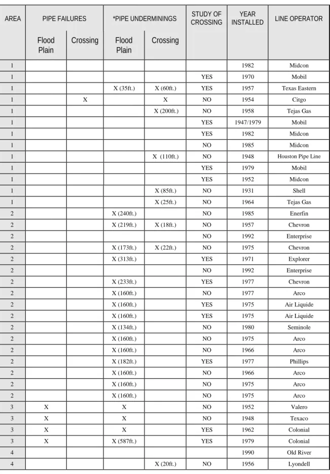
Damages --Thirty-seven of the 69 pipelines that cross the flood plain were either ruptured or undermined during the flood; 13 at river crossings only, 18 at locations within the flood plain not at crossings, and 6 in both locations. Eight of the 69 pipelines ruptured during the flood; 4 at river crossings and 4 in the flood plain.
Only 12 of the 25 operators that provided information on the design bases of their pipelines indicated that they had performed some type of study of the river crossing to augment their design decisions. (Survey responses did not include details on the types of studies performed.)
The other 13 operators cited industry codes, Federal regulations, or both as the bases of their pipeline designs. No operator indicated that it had used the American Petroleum Institute’s Bulletin 1105, Bulletin on Construction for Oil and Products Pipe Lines (first edition, 1955) or performed a comprehensive study of the flood plain.
Spill Prevention -- Fifty of the 69 pipelines were regularly patrolled during the flood by employees in aircraft, walking the pipeline route, or stationed on either side of the flood. While the operators’ efforts to patrol the flooded pipelines were reasonably uniform, their actions to minimize the potential consequences of a pipe rupture were not.
26
Table 1 - Effects on stream stability
Modification General Action Impact on San Jacinto Flood Plain
Channel Alterations Include constrictions to maintain a navigation channel and highway crossings, both of which increase water velocities and the rate of sediment transport.
In 1940, the San Jacinto was a lazy meandering river unspoiled by development. The Lake Houston Dam was completed in 1954. The eastbound Interstate 10 bridge span was constructed in 1951–55 and the westbound bridge was built in 1971. The new U.S. Route 90 was constructed in the 1980s, and other road crossings were also constructed across the San Jacinto flood plain. Streambed Mining
for Sand and Gravel
Usual result is streambed degradation. Dam and reservoir effects on downstream stability depend on stream flow characteristics caused by stream flow regulation. Postconstruction flows during floods tend to be of lesser magnitude but longer duration. Can be beneficial or detrimental, depending on the balance between sediment supply and transport capacity.
The Corps of Engineers issued several permits over the years for streambed mining, both upstream and downstream of Banana Bend. Sand mining began in 1944 and continued up to 1989. The result was formation of lagoons along and adjacent to the streambed.
Land-Use Changes Such changes include agricultural activities, urbanization, commercial development, and road construction, which can accelerate erosion, causing streams to overload with sediment and lowering the ground water table, resulting in subsidence. However, once an area is fully developed, the watershed becomes a low sed