WHICH QUALIFICATION: WHICH MODEL.
Dr. F. R. YOUNG
Head, Surveying and Land Information Faculty of Engineering and Surveying University of Southern Queensland
TOOWOOMBA. QLD. 4350 Phone: +61 7 4631 2546
Fax: +61 7 4631 2526 [email protected]
Introduction
The diverse needs for education and professional development within the Spatial Science (Surveying and mapping) profession have defined multiple and significant learning opportunities. From 2005 University of Southern Queensland will increase its unique suit of undergraduate study options from which individuals can choose to enter the spatial science profession. All existing post-graduate formal education and CPD options are retained to enable professionals to tailor-make professional development to fit their changing workplace environments. The opportunity to choose on-campus, off-campus, on-line web (limited) delivery modes of study, or a combination of these, and to move freely between or in-and-out of these modes, realises the dilemmas facing contemporary and emerging professionals.
Our profession is embracing needed change to reflect specific changes imposed by the current and perceived future social environment (Young, 1994 and Young, 2004). This paper will concentrate on examining the major criteria and benefits of the new user-defined technical and professional education Spatial Science programs developed at the University of Southern Queensland.
Background
Educational institutions need to provide for prospective students with varying backgrounds, locations, work environment needs, forms of access and levels of learning. With an increasingly diverse range of work situations and individual's workplace and job mobility, specific learning options are required. These options also need to address the employers and governments increasing demands for specific qualification or certification to ensure competence and meet society’s quality requirements. While technical training can often be gained with vendors of specific systems, the sophistication and complexity in applying new techniques and technologies in innovative ways requires education as well as training.
Increasing scrutiny of professional activity has placed higher demands on the abilities, and reporting of, analysis, evaluation, assessment, conceptualisation and synthesis outcomes. These applications to professional practice must be conceptualised and related to any impact on society and government thinking i.e. has social spatial connectivity. In addition, professional practice education should provide skills to enable graduated to be proactive, innovative and have lateral thinking or entrepreneurial skills. Although we are unable to know conclusively what expertise is required for the future (Young 1977), new graduates will need to have:
• Good communication skills;
• Current technical competence;
• A high level of conceptual and thinking skills;
• A capacity for innovative thinking, good judgements and analytical and critical evaluation;
• An ability to adopt and adapt;
• A spatial science’s technology literacy and numeracy;
• A spatial connectivity ability;
• A capacity for contextual understanding of their work environments;
• An ability to discriminate between and use information sources;
• Administrative, management and human relations abilities;
• A capacity to synthesis knowledge for solving problems and decision making;
• Knowledge of individual responsibilities and accountability;
• An ability for independent and lifetime learning; and
• A suitably developed attitude, motivation and behaviour focus in accordance with the profession.
Education Opportunities
The Surveying and Land Information Discipline (http://www.usq.edu.au/faculty/engineer/survey/), an integral part of the Faculty of Engineering and Surveying, has developed its existing teaching programs to form a new articulated suite of offerings that enable students to progress to their highest potential. The following programs (table 1) will be offered from 2005: the interrelationship of undergraduate programs are depicted in figures 1 and 2.
Table 1: Education options at USQ.
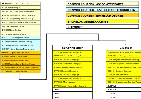
Figure 1 displays the common core courses and the two major study options for the four (4) year Bachelor of Spatial Science degree. A similar structure exists for the three (3) year Bachelor of Spatial Science
Technology and the two (2) year Associate Degree in Spatial Science (figure 2). The study paths of each major are hierarchical with seamless articulation between each degree level. The other advantages of this structure are:
• Free movement between the surveying and GIS majors provided by the high level of course commonality.
• Change to the other major to correct an initial career decision.
• Students who enter at a ‘lower’ level degree can choose to commence a higher degree in either the off-campus or on-off-campus mode that best suits their financial, workplace and personal needs.
• Gain two degrees of an equal or a higher level by completing the requirements of the related other major.
• Use the electives to choose an individually preferred or work-place needed specialisation.
• Drop back from one level to a lower level of study to accommodate changed circumstances.
GIS1401 Geographic Data Presentation
CIS1001 Intro to Business Programming ENG2002 Technology and Society SVY3202 Photo and Remote Sensing
MAT1102 Algebra and Calculus 1 ENG411 Research Project Part 1 ENG4112 Research Project Part 2 ACC1101 Accounting for Decision Making SVY4309 Practice Man. For Spatial Scientists SVY4306 Land Law & Valuation
LEGEND
MAT1100 Foundation Mathematicss SVY1102 Surveying A
ENG1101 Engineering Problem Solving 1 ENG2102 Engineering Problem Solving 2 ENG1001 Princ. of Prof Eng and Surveying GIS1402 Introduction to GIS
ENV2201 Land Studies SVY1101 Introduction to GPS
COMMON COURSES - ASSOCIATE DEGREE
COMMON COURSES – BACHELOR OF TECHNOLOGY
COMMON COURSES - BACHELOR DEGREE
BACHELOR DEGREE COURSES
ELECTIVES
ELECTIVE
GIS3405 Spatial Analysis and Modeling
CSC3400 Database Systems
SVY2105 Survey Computations B SVY2106 Geodetic Surveying A
SVY3304 Cadastral Surveying SVY2301 Automated Surveying Systems
SVY2303 Construction Surveying CIV2701 Road Design and Location
ELECTIVE ELECTIVE
Surveying Major
GIS3406 Remote Sens & Image Processin GIS2403 Land Management Systems
GIS3404 Geographic Data Visualisation CSC1401 Foundation Programming with C
ELECTIVE ELECTIVE
GIS Major
SVY2106 Geodetic Surveying B GIS4407 Web based GIS
SVY42302 Mine Surveying
ELECTIVE SVY3201 Urban Design & Development
CSC2402 Object Orientated Program. in c+ CSC3402 Graphical User Interface Program SVY1104 Survey Computations A
ELECTIVE SVY4203 Urban and Regional Planning
GIS1401 Geographic Data Presentation
CIS1001 Intro to Business Programming ENG2002 Technology and Society SVY3202 Photo and Remote Sensing
MAT1102 Algebra and Calculus 1 ENG411 Research Project Part 1 ENG4112 Research Project Part 2 ACC1101 Accounting for Decision Making SVY4309 Practice Man. For Spatial Scientists SVY4306 Land Law & Valuation
LEGEND
MAT1100 Foundation Mathematicss SVY1102 Surveying A
ENG1101 Engineering Problem Solving 1 ENG2102 Engineering Problem Solving 2 ENG1001 Princ. of Prof Eng and Surveying GIS1402 Introduction to GIS
ENV2201 Land Studies SVY1101 Introduction to GPS
COMMON COURSES - ASSOCIATE DEGREE
COMMON COURSES – BACHELOR OF TECHNOLOGY
COMMON COURSES - BACHELOR DEGREE
BACHELOR DEGREE COURSES
ELECTIVES
ELECTIVE
GIS3405 Spatial Analysis and Modeling
CSC3400 Database Systems
SVY2105 Survey Computations B SVY2106 Geodetic Surveying A
SVY3304 Cadastral Surveying SVY2301 Automated Surveying Systems
SVY2303 Construction Surveying CIV2701 Road Design and Location
ELECTIVE ELECTIVE
Surveying Major
GIS3406 Remote Sens & Image Processin GIS2403 Land Management Systems
GIS3404 Geographic Data Visualisation CSC1401 Foundation Programming with C
ELECTIVE ELECTIVE
GIS Major
SVY2106 Geodetic Surveying B GIS4407 Web based GIS
SVY42302 Mine Surveying
ELECTIVE SVY3201 Urban Design & Development
CSC2402 Object Orientated Program. in c+ CSC3402 Graphical User Interface Program SVY1104 Survey Computations A
[image:2.595.55.529.419.752.2]ELECTIVE SVY4203 Urban and Regional Planning
Surveying and Land Information Courses
The commonality of courses ensures a breadth of knowledge and technical competence commensurate with practices in the surveying and land information profession. The structure has also addressed the following cognitive stages:
First-year courses assimilate students into the profession and its role and provide basic technical competence and knowledge.
Second-year provides a higher technical competence and applications knowledge and an ability to lead a small field party.
Highest technical competence and understanding is achieved with third-year courses. Conduct and manage tasks.
[image:3.595.110.535.309.659.2]The fourth-year courses are largely professional and project management and higher ‘academic’ studies. This prepares graduates to meet professionalism and management demands, the intellectual challenges of CPD, and address higher level technical and innovative application needs.
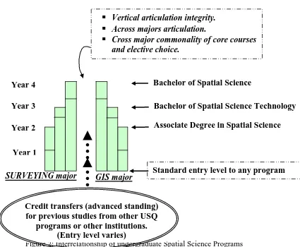
Figure 2: Interrelationship of undergraduate Spatial Science Programs
SURVEYING major
GIS major
Bachelor of Spatial Science
Bachelor of Spatial Science Technology
Associate Degree in Spatial Science
Vertical articulation integrity.
Across majors articulation.
Cross major commonality of core courses
and elective choice.
Year 4
Year 1
Year 3
Year 2
Credit transfers (advanced standing)
for previous studies from other USQ
programs or other institutions.
(Entry level varies)
Standard entry level to any program
Not all workplace needs are technical or professional specific applications, hence the development of innovative curricula to ensure a more complete education. For example, the Problem Solving courses (non traditional discipline academic content) have been introduced to address workplace challenges faced in a team environment and prepare students in a more gestalt way to deal with those challenges. The main activities include multidiscipline problems solving in teams so that the following skills are learnt/experienced in context:
• Planning, organising, and managing (group and personal).
• Mathematics, physics and statistics knowledge, application and relevance.
• Teamwork and individual contribution.
• Basic research techniques.
• Knowledge-based association with other disciplines and role or function of his/her own discipline in relation to other professions and society.
The skills acquired in the Problem Solving courses are built-on throughout the program as integral elements of each course to achieve a broad professional competence level. Increased emphasis has been given to communications through establishing a minimum of one course per year as a communications benchmark. This means that, despite the content of a course, 30% of the marks are awarded to the professional communication of outcomes: a pass in the communication 30% is required before the course can be passed. The final year in the Bachelor degrees includes a research dissertation of approximately 20,000 words plus a conference presentation to ‘demonstrate’ all the skills and knowledge gained from the program: it also establishes competence in researching and major report writing.
The programs include task oriented Practice Courses, in addition to the academic courses (figure 2), which consolidate technical skill learning in individual courses within the programs. For the off-campus student, the residential schools also enable face-to-face contact with staff, other students and fulfil the need to experience the university ethos. The residential schools associated with the research project also facilitate student contact with professional and regulatory bodies; enables reinforcement of professional development issues; and enables students to experience the benefits of a professional conference.
Student Support and Entrance Options
Entrance into USQ’s spatial science programs accommodate the diverse avenues for individuals entering from Year 12, another discipline, mature age or another institution. Year 12 students can enter any of the undergraduate programs of their choice, restricted only by their level of achievement at school. Potential students from other programs and other institutions are offered credit on previous studies to reduce the time and cost to achieve their aims. USQ also offers Tertiary Preparation Programs (http://www.usq.edu.au/tpp) that enable individuals without the minimum year 12 matriculation or other tertiary studies to achieve an entrance level. Any part or the entire program can be completed on-campus or off-campus without leaving a current work place. Enrolment into the programs occurs twice a year, the beginning of both semester 1 and semester 2, to provide further flexibility.
User defined education works best when the user can choose the time and place to conduct the learning aspects of that education (McDougall et al. 2003 and Young, 2002). Student support facilities for off-campus education require a broad range of on-off-campus services. Administrative, distance education and academic staff are contactable through a variety of mechanisms including: email; telephone; facsimile; post; via Outreach (a specialised student support service); through regional centres; via the on-campus international Office; offshore agency offices; and through the USQConnect student web portal (https://usqconnect.usq.edu.au/). These services are designed to assist in pedagogical aspects that increase a student's sense of involvement and facilitates good learning. Electronic support services provide all students with 24 hours per day ability to access the majority of information and facilities available to students.
The majority of the Spatial Science courses are supported by customised study materials developed by the staff. These can include an introductory book (assessments and administration and study information); study book; book of readings; and multimedia enhancement materials (hardcopy, CD/DVD or web based). The first two chapters of the study book are also accessible via the web to enable student to commence before the study material arrives through the post.
The study materials and the university student support structures ensures that every effort is made to ensure off-campus students receives an equivalent teaching an learning experience and access to that of the on-campus student. This enables the spatial science programs to continue to deliver professional and paraprofessional education and training to meets the needs of employers and the profession.
Although programs and courses curricula cannot be entirely market driven, the Surveying and Land Information discipline and USQ are fostering the responsibility for maintaining professional education standards while incorporating market-place forces where possible. User defined professional education is regarded as highly desirable and logical to provide a quality professional suite of options that accommodates participant's needs.
The new Spatial Science program structure incorporates the ability to continually advance curricula to adopt current and perceived future trends. These programs are strategically planned; systematically integrated; and institutionally comprehensive student support infrastructure to provide sustainable and quality distance education.
The Surveying and Land Information's flexibility of study modes, program content, interrelated program options and specific CPD opportunities address the profession's educational needs and maximise links and benefits among participants, employers, higher education institutions and professional organizations. This structure encourages a cohesive, integrated and co-operative approach to paraprofessional and professional education and continuing education opportunities: it also addresses the social issues, work place restrictions and the general limited time and economic resources concerns of participants.
Acknowledgement
Curricula developments and their implementation is a team effort. The USQ’s Surveying and Land Information staff are commended for their input, efforts and enthusiasm in developing the new Spatial Sciences suite of programs.
References
McDougall. K, Young, F. R, Apan. A, 2003. Operational Infrastructure For Quality Distance And Online Geospatial Programs, Cartography, 32(1), 25-38.
Young, F. R. 1994. Flexible education for the future generic surveyor/cartographer, Proceedings of XX FIG International Congress, March, 1994, Melbourne, pp. 211-223.
Young, F. R. 1997. The changing face of education: meeting the surveying and mapping education needs, The Australian Surveyor, vol. 42, no. 4, pp. 148-155.
Young, F. R 2002: User Defined Professional Education Opportunities, 26th National Surveying Conference, 8-12 July, Darwin, Australia.