The natural distribution of Eucalyptus
species in Tasmania
Abstract
A summary is provided of the natural geographic distributions of the 29 Tasmanian Eucalyptus species. The work is based on over 60 000 observations from numerous data sources. A map on a 10 km x 10 km grid-cell scale is presented for each species and is accompanied by graphs of the altitudinal range and flowering times, as well as descriptive notes on distribution and ecology, supplemented with a list of key references. The geographic pattern of species richness is examined at generic, subgeneric and series levels. Total species richness is greater in the drier, eastern regions compared to the wet, western regions of Tasmania, with highest concentrations of species occurring mainly in the central east coast and south-eastern regions. Monocalyptus species occur in 8% more grid cells than
Symphyo-myrtus species but are absent from King Island.
At the series level, greatest species richness is reached by the Obliquae in the north-east, the
Piperitae in the south-east, the Ovatae on the
central east coast, and the Viminales in highland areas of the south-east and Central Plateau. Series
Obliquae species are absent from Flinders Island
and are poorly represented in the south-west.
The general patterns of eucalypt distribution and ecology are reviewed. Species are classified into nine categories based on the grid cells they occupy within their geographic range. The most widespread species are E. delegatensis, E. obliqua, E. ovata,
E. viminalis and the endemic E. amygdalina.
Most species with localised distributions have been nationally recognised as rare (i.e. E. barberi,
E. morrisbyi, E. perriniana and E. risdonii).
Rare species with regional distributions have either
dispersed (E. cordata) or disjunct (E. archeri) occurrences. Most species that are rare in Tasmania are endemics, with the exception of
E. perriniana and E. aff. radiata, although
the taxonomic status of the latter requires investigation. Unresolved issues relating to the natural distribution and taxonomic affinities of the Tasmanian eucalypt species are summarised.
Introduction
In Tasmania and the Bass Strait islands, 29 native eucalypt species (one of which has two subspecies) are recognised by Buchanan (1995), from two informal subgenera,
Monocalyptus and Symphyomyrtus (Pryor and
Johnson 1971). In the present study, we have treated all Tasmanian records of Eucalyptus
globulus as E. globulus subsp. globulus. The
other subspecies of E. globulus listed for Tasmania, subsp. pseudoglobulus, occurs only in forms which intergrade with E. globulus subsp. globulus (Jordan et al. 1993) and we do not include it here as a separate taxon.
The Tasmanian native eucalypts include 12 species from two series in the subgenus
Monocalyptus and 17 species from two series
in the subgenus Symphyomyrtus (Table 1)1. Seventeen taxa are known to be endemic to Tasmania (Brown et al. 1983), including
E. delegatensis subsp. tasmaniensis (Boland
1985). The Monocalyptus and Symphyomyrtus K.J. Williams and B.M. Potts Cooperative Research Centre for Temperate Hardwood Forestry, Department of Plant Science, University of Tasmania, GPO Box 252–55, Hobart 7001 email: Kristen.Williams@plant.utas.edu.au./B.M.Potts@plant.utas.edu.au
Table 1. Taxonomic classification of the Tasmanian Eucalyptus species (after the informal classification of Pryor and Johnson 1971). Authorities for nomenclature follow Chippendale (1988). Subgroupings of the series Viminales generally follow Jackson (1965) and Duncan (1989) except E. cordata which has closest affinities with the alpine white gum subgroup (Pryor and Johnson 1971). Common names for series groups follow Duncan (1989; see also Jackson 1965). Eucalyptus globulus subsp. globulus includes forms which intergrade morphologically with the mainland taxon E. globulus subsp. pseudoglobulus (Jordan et al. 1993). (* = Tasmanian endemic)
SUBGENUS Symphyomyrtus
Series Ovatae (Black Gum Group)
* E. barberi L. Johnson & Blaxell E. brookeriana A.M. Gray E. ovata Labill.
* E. rodwayi R. Baker & H.G. Smith
Series Viminales (White Gum Group)
White gum subgroup
E. dalrympleana Maiden subsp. dalrympleana E. rubida Deane & Maiden
E. viminalis Labill. subsp. viminalis
Yellow gum subgroup
* E. johnstonii Maiden
* E. subcrenulata Maiden & Blakely * E. vernicosa J.D. Hook.
Blue gum subgroup
E. globulus Labill. subsp. globulus
Alpine white gum subgroup
* E. archeri Maiden & Blakely * E. cordata Labill.
* E. gunnii J.D. Hook. * E. morrisbyi Brett
E. perriniana F. Muell. * E. urnigera J.D. Hook. SUBGENUS Monocalyptus
Series Obliquae (Ash Group)
* E. delegatensis R.T. Baker subsp. tasmaniensis Boland E. obliqua L’Hér.
E. pauciflora Sieber ex Sprengel subsp. pauciflora E. regnans F. Muell.
E. sieberi L. Johnson
Series Piperitae (Peppermint Group)
* E. amygdalina Labill. * E. coccifera J.D. Hook. * E. nitida J.D. Hook. * E. pulchella Desf.
E. aff. radiata Sieber ex DC. * E. risdonii J.D. Hook. * E. tenuiramis Miq.
This atlas of the natural geographic and altitudinal distribution of the Tasmanian
Eucalyptus species is a compendium of
annotated maps on a 10 km x 10 km grid-cell scale, collated from diverse information sources. Mapping has been the first stage in screening for errors in a database that will ultimately be used for predictive analyses, contribute to land management decisions and assist ecological research. The main impetus for publishing these distributional data is to subgenera are reproductively isolated (Ellis
et al. 1991) but, within subgenera, extensive
Figure 1. Species of Eucalyptus native to Tasmania, showing species which form clines and natural hybrids. Hybrids only occur within subgenera. For each species, follow horizontal and vertical axes. For example, E. barberi is known to hybridise with E. brookeriana and E. ovata (horizontal axis) and possibly with E. globulus, E. gunnii and E. cordata (vertical axis). † E. delegatensis is represented in Tasmania by an endemic subspecies. (Figure adapted from Duncan 1989)
Jackson (1965) are still the main overall source of information on the distribution of eucalypt species in Tasmania (e.g. Davidson et al. 1981; Forest Resources 1995). Other publications such as Boland et al. (1984) and Chippendale (1988) include broad-scale maps of Tasmanian eucalypt species in the context of Australia-wide eucalypt occurrences. Local texts such as Kirkpatrick and Backhouse (1985) and the atlas of Tasmanian endemics (Brown et al. 1983) include eucalypts in the context of other Tasmanian plant species. Mapping at higher resolutions, such as the 1:500 000 distribution maps of vegetation types (Kirkpatrick and Dickinson 1984), tall eucalypt forest types (Forestry Commission 1988), and the specific studies of wet and dry eucalypt forests by Wells (1989) and Williams (1989) display the predominance of eucalypts in the landscape (cf. Pryor and Johnson 1981). Regional and quantify current knowledge, to stimulate the
collection of herbarium voucher specimens from new localities, and to encourage the verification of outliers. It is important to clarify the natural distribution of Eucalyptus species in Tasmania as land clearing and plantings for ornamental and forestry purposes will eventually confuse natural and artificial occurrences. The maps and graphs presented should allow clear assessment of whether an occurrence is novel and represents an extension of the geographic or altitude range of a species, or whether it represents a poorly verified or well-known location.
Previously published data on eucalypts
local vegetation mapping has also contributed significantly to our knowledge of eucalypt occurrences. For example, Brown and Bayly-Stark (1979a) mapped the vegetation of Maria Island, Duncan (1983) mapped communities in the Douglas River region, Brown and Duncan (1989) mapped the vegetation of Tasman Peninsula, Fensham (1989) reconstructed the vegetation patterns for the Midlands from extant and remnant community distributions, and Kirkpatrick and Balmer (1991) mapped the northern portion of the Cradle Mountain – Lake St Clair National Park (see also Corbett and Mackie 1994).
Geo-coded flora inventory surveys with well-designed sampling strategies provide a lasting contribution to our knowledge of the distribution patterns of eucalypts. Such inventories include, for example, the broad-scale vegetation surveys of heathlands (Kirkpatrick 1977), dry sclerophyll forests (Duncan and Brown 1985), grassy woodlands (Kirkpatrick and Duncan 1987; Kirkpatrick
et al. 1988a), wet eucalypt forests (Neyland
1986; Kirkpatrick et al. 1988b), swamp forests
(Pannell 1992), rainforest (Jarman et al. 1984, 1991), riparian vegetation (Askey-Doran 1993), buttongrass moorlands (Jarman et al. 1988), and alpine vegetation (e.g. Kirkpatrick 1980, 1984a, b; Kirkpatrick and Harwood 1980; Kirkpatrick and Whinam 1988). Other purpose-specific flora inventory surveys encompass many local areas in particular regions throughout Tasmania; for example, the non-allocated Crown land surveys (e.g. Duncan 1986; Neyland 1988a, b; Neyland and Duncan 1988a, b; Slater 1988; Cullen 1990; Mendel 1991), the land system surveys (Richley 1978, 1984; Pinkard 1980; Pinkard and Richley 1984; Pemberton 1986, 1991; Davies 1988), and the numerous unpublished environmental impact and investigation surveys of Crown and private land areas by management agencies such as Forestry Tasmania, the Department of Environment and Land Management, the Department of Primary Industry and Fisheries, Works Tasmania, and local councils.
For reasons of inherent interest, or for
management-orientated research and academic study, many individuals have also
taken flora surveys of local land areas such as the Rheban Spit (Bowden and Kirkpatrick 1974), Cape Raoul (Kirkpatrick 1975c), Mount Wellington Range (Ratkowsky and Ratkowsky 1976, 1977, 1982), East Risdon Nature Reserve (Brown and Bayly-Stark 1979b), Hellfire Bluff (Harris and Brown 1980), Rocka Rivulet (Duncan et al. 1981), Cherry Tree Hill (Duncan and Duncan 1984), Ben Lomond National Park (Davies and Davies 1989), Table Cape (Willis 1991) and Hummocky Hills (Ratkowsky et al. 1993c). Details of the distribution of some species have become known following studies of the genetic structure of populations such as
E. barberi (McEntee et al. 1994), E. cordata (Potts
1989), E. globulus (Kirkpatrick 1974, 1975b; Jordan et al. 1993, 1994), E. gunnii and
E. archeri (Potts 1985; Potts and Reid 1985a, b), E. morrisbyi (Wiltshire et al. 1991b), E. perriniana
(Wiltshire and Reid 1987), E. risdonii and
E. tenuiramis (Wiltshire et al. 1991a, 1992) and E. vernicosa, E. subcrenulata and E. johnstonii
(Jackson 1960). Information on distributions has also been derived from ecological studies such as those on interactive effects of drought, frost and waterlogging (e.g. Davidson and Reid 1985, 1987, 1989), insolation (e.g. Kirkpatrick and Nunez 1980), fire regime (e.g. Neyland and Askey-Doran 1994), and the nature of an inverted tree-line (e.g. Gilfedder 1988).
Collectively, these diverse studies have assisted in formulating the conservation status of individual species (e.g. Brown et al. 1983; Briggs and Leigh 1988; Kirkpatrick et al. 1991a, b) and communities (e.g. Kirkpatrick
et al. 1994), enabling priorities to be identified
for management and research (e.g. Wiltshire
et al. 1989). Collation of the distribution
information from these and other studies is summarised here for eucalypts.
Methods
Species nomenclature
Subspecies have been abbreviated to their species name wherever appropriate, providing this leads to no ambiguity in a Tasmanian context, and no loss of clarity in the discussion.
Data collation
A generalised 10 km x 10 km map scale, corresponding to the Australian Map Grid (AMG) system, has been widely used in Tasmania for presenting the distributions of native plant and animal communities or taxa (e.g. Thomas 1979; Brook 1979; Brown et al. 1983; Kirkpatrick et al. 1988a, b). The eucalypt distribution maps are based on over 60 000 records collated from the published literature (7%), unpublished reports (7%) and existing databases (86%), where these could at least be located within a 10 km x 10 km grid cell. Literature from which records were derived is indicated in the Bibliography (see p. 150). The existing databases were contributed by Forestry Tasmania (CFI, Lawrence 1978; floristic data, Orr and Manson 1994), the Tasmanian Department of Environment and Land Management (TASPAWS/TASFORHAB databases, Peters 1983), and CSIRO Division of Plant Industry (EUCALIST, Chippendale and Wolf 1984). Extensive distribution data held in collections at the Tasmanian Herbarium were accessed via EUCALIST prior to 1984, or directly from the Herbarium for later collecting dates. The unpublished reports of Forestry Tasmania were derived largely from the botanical surveys of Forest Reserves, Recommended Areas for Protection (RAPs) and forest coupes prior to logging. The unpublished reports of the Department of Environment and Land Management comprised investigation surveys and specific research projects. Other unpublished records were generously provided by individuals of these Government agencies and the University of Tasmania, or unaffiliated field botanists. The published literature was generally derived from Tasmanian and Australian journals on botany, forestry and ecology, and locally produced reports.
Data verification
single records in a grid cell on the margins of a distribution. Such occurrences that were considered possible, albeit unlikely, were usually deleted from the distribution maps and discussed in the text for each species as unverified outliers. Particular attention was also paid to inconsistencies with the original maps of Jackson (1965) and locations in Brown et al. (1983) which were unverified.
Collated occurrences which were clearly in error were omitted from the maps. These errors included clear misidentifications for historic or accidental reasons and mis-read or mis-typed grid references. In some cases, errors arose in conversion of locations from minutes of latitude and longitude to AMG. The conversion frequently placed the record in an adjacent and incorrect 10 km x 10 km grid cell. For example, records of E. coccifera with a location given as 'Herringback' appeared in grid cell 5023 following conversion of latitude and longitude to AMG, but the location actually refers to cell 5123. In other cases, earlier collectors, in the absence of accurate maps, gave descriptions with reference to the nearest landmarks and named places which, when converted to latitude and longitude, lead to some spurious locations due to the existence of several places by the same name or the same place by different names. For example, Mount Wellington in southern Tasmania was referred to previously as Plateau Mountain or Table Mountain, and when Robert Brown collected E. globulus in 1804 from the 'Derwent River Table' or 'Table Mountain', it was incorrectly attributed to Table Mountain in the Midlands. Other causes of error are outdated nomenclature in some species or the difficulties of distinguishing morphologically similar species and their intergrading forms. For example, the fine-leaved peppermints E. amygdalina and
E. nitida may appear superficially similar when
adult leaves, fruits and buds are compared, but are more readily distinguished on bark and habitat. In the case of their intergrading forms, the naming preferences of different recorders are expressed. Overlapping nomenclature is particularly apparent for data collated from numerous sources.
Some other inadvertent errors have arisen in the database following the collation of published distributions where these are based upon floristic classifications and summarised data (e.g. Kirkpatrick et al. 1988a, b; Askey-Doran 1993). In such cases, the community nomenclature which is frequently derived from the dominant tree species and vegetation type does not necessarily reflect a verifiable presence for that species.
Errors of these types in the distribution data accounted for approximately 5% of the initial 63 567 records, leaving 60 412 records
available for mapping2.
Sampling bias due to duplicated and
replicated data may have masked some records that would otherwise have been reviewed for potential error. For example, duplication in the data arises where field records of some collectors have been used in several publications, collated in several databases, and voucher specimens simultaneously lodged with different herbaria, giving a perception of several separate sources. Intensive sampling in some locations relative to others (replication) may also contribute to enhanced perceptions of record validity. The degree of multiple occurrences of data or sources in each 10 km x 10 km grid cell results in considerable redundancy at this scale. The raw data have a redundancy of approximately 75% and the sources themselves have a redundancy of approximately 40%. To over-come some of these problems of sampling bias, an indication is provided for each grid cell of the the number of separate sources recording the presence of a species. It was felt that displaying separate sources, rather than the number of records per cell gave a better indication of independent identifications and thus the reliability of the presence of a species.
In the context of the number of sources per grid cell per species, the overall rate of
obvious error and unverified observations accounts for approximately 14% of the initial 16 523 observations from the condensed set of data, leaving 14 185 independent identifications available for mapping. The verified data are derived from 441 different sources and the unverified data derive from 89 sources. Together, the data comprise 455 distinct sources.
Altitude occurrences and flowering time
Altitude occurrences in 100 m classes and monthly flowering incidence for each species accompany the distribution maps. The altitude data were collated with distribution records. Obvious errors in the altitude records were screened by considering outliers in the context of the predominant habitat for each species and the upper and lower limits of the particular response curve. Sampling bias among the altitude records for each species was reduced by combining, into a single observation, replicates from the same grid cell which differed by less than 10 m. This left 20 169 records for defining the response curves.
The flowering-time records were separately collated from EUCALIST (Chippendale and Wolf 1984), with additional records from the Tasmanian Herbarium (up to 1992), field notes (BMP) and published data (E. gunnii Potts and Reid 1985a, b; E. urnigera Savva et al. 1988; E. cordata Potts 1989). Flowering times are given for a 15-month period starting from May (autumn) to produce an optimal display of the response curves for most species. In several cases, the flowering information will be biased by extensive records from specific studies, involving specific years or specific localities or, conversely, by inadequate data.
Response curves for flowering times are defined by a moving average (summed weights of 0.5 to the observation and 0.25 to each adjacent record), where each observation represents the middle of the respective month. Absence data were not available for either flowering times or altitude responses. Thus, the documented responses (see relevant Figures on pp. 49–121) are conditional
probabilities which reflect the distribution of occurrences in the specified classes.
Distribution types and conservation status
The collated data were used to explore some attributes of species' distributions (see Rabinowitz 1981). The geographic range of each species within Tasmania was estimated by connecting occupied grid cells from the outer marginal extremes of a core distribution, or from the coast, to outliers by straight lines and interpolating the number of cells within the resulting envelope (e.g. see 'extent' in Gaston 1996). The aggregation of species occurrences within their range was estimated as a percentage of the occupied grid cells and the geographic range. The continuous
variation in the distribution of the Tasmanian eucalypts is categorised into nine types based on the geographic range and aggregation of occurrences for each species.
Distribution maps, habitat descriptions and community classifications
Distribution, altitude profiles and flowering times for the 29 eucalypt species, in
cited in the annotated text for each species. Other specific sources used are indicated in the text for each species. Key references on the biology of a particular species are listed in alphabetical order. Locations mentioned
when commenting on the distribution of a species are referenced to 10 km x 10 km grid cells which are directly related to the Tasmanian TASMAP series (Department of Environment and Land Management).
Atlas of distributions of Tasmanian eucalypts
New records
The authors welcome new locations for Tasmanian eucalypts, and information on the unverified or doubtful records discussed in this atlas. All records should be in writing, stating location of the plant, date of observation/collection, and name of the collector and/or person providing the information. It is important that range extensions (geographic or altitudinal) are supported by the collection of herbarium material (providing it causes minimal damage to the plant), since voucher specimens provide the best level of verification of a species (see Duncan 1996, this volume).
= > 5 = 3–5
= 1, 2
Legend to distribution maps: Dot size reflects the number of separate sources recording presence in a grid cell (see p. 45).
Species Common name in Tasmania page
E. amygdalina black peppermint 48
E. archeri Archer's gum, alpine cider gum 51
E. barberi Barber's gum 53
E. brookeriana Brooker's gum 55
E. coccifera snow peppermint (snow gum) 58
E. cordata heart-leaved silver gum 61
E. dalrympleana subsp. dalrympleana mountain white gum 64
E. delegatensis subsp. tasmaniensis gum-topped stringy bark, white-top 66
E. globulus subsp. globulus blue gum 69
E. gunnii cider gum 72
E. johnstonii yellow gum 75
E. morrisbyi Morrisby's gum 77
E. nitida Smithton peppermint 79
E. obliqua stringy bark, brown-top 82
E. ovata swamp gum, black gum 85
E. pauciflora subsp. pauciflora cabbage ash, weeping ash (cabbage gum, weeping gum) 88
E. perriniana spinning gum 91
E. pulchella white peppermint 93
E. aff. radiata 96
E. regnans giant ash (swamp gum) 99
E. risdonii Risdon peppermint 102
E. rodwayi black swamp gum (swamp peppermint) 104
E. rubida candlebark 106
E. sieberi ironbark 108
E. subcrenulata alpine yellow gum 110
E. tenuiramis silver peppermint 112
E. urnigera urn gum 115
E. vernicosa varnished gum 118
E. viminalis subsp. viminalis white gum, manna gum 120
Table 2. Index to species in the atlas of Tasmanian eucalypts. Common names for species mostly follow, or are based
Eucalyptus amygdalina
SUBGENUS: Monocalyptus SERIES: Piperitae
Common name: black peppermint
and with E. pulchella towards the east coast and throughout the Eastern Tiers on dolerite substrates.
Eucalyptus amygdalina is predominantly a
lowland species, generally occurring from near sea-level to 600 m but occasionally up to 800 m, with rare, scattered occurrences up to 1020 m (Figure 3). The higher altitude occurrences are known from the Eastern Tiers near Snow Hill and Mount Foster, and from the south-eastern Central Plateau and Western Tiers. Its main flowering period is
Eucalyptus amygdalina is a widespread and
common endemic species of eastern coastal regions and inland tiers and plateaux (Figure 2). It occurs on undulating or steep terrain across a wide range of substrates that are generally infertile, comparatively sunny and periodically drought prone. It is generally absent from the wetter regions of western Tasmania, and the upland regions of the Central Plateau and north-east. It intergrades with E. nitida in the north-western coastal region and towards the south-west along the western margins of its distribution,
Figure 4. Flowering times for E. amygalina.
heathy where drainage is rapid (e.g. deep sands and granitic slopes), grassy on alluvial flats with medium drainage and a relatively high fire frequency, and sedgey on the margins of hollows with seasonally poor drainage. Alternatively, on dolerite and granite substrate-types, heathy understoreys develop in well-drained, undulating terrain, grassy woodlands develop on the stoney flats of inland tiers and plateaux with slightly impeded drainage, and shrubby communities develop on the more insolated rocky slopes and ridges. Wet sclerophyll understoreys occur locally in northern inland regions, and on the protected slopes and aspects of mountainous and hilly terrain elsewhere. Eucalyptus obliqua frequently co-exists with E. amygdalina in these ecotonal situations of increased moisture availability and substrate fertility. Eucalyptus viminalis is a common subdominant or minor species which may be replaced by E. dalrympleana in upland situations. Other species which may occur with
E. amygdalina include E. globulus in shaded
gullies, or E. ovata on poorly drained sites.
COMMENTS: There are several unverified outliers on the west coast from north of West Point to Macquarie Harbour (cells 2946, 3044, 3046, 3141, 3532, 3533, 3633, 3830), and south to Cox Bight (cells 4020, 4120, 4318). Other unverified outliers or unverified marginal occurrences are recorded from western and north-western inland regions (cells 3544, 3545, 3637, 3931) or adjacent to the Lyell Highway and the Gordon–Serpentine impoundments (cells 4033, 4134, 4233, 4234, 4235, 4324, 4327, 4328, 4426, 4429, 4527). Some of these may be actual occurrences of E. amygdalina, but others may represent forms intergrading with
E. nitida or misidentifications of E. nitida. A
similar westward extension of E. amygdalina between Savage River and Guildford in the north-west (cells 3540, 3640, 3641, 3740, 3741, 3840, 3841) and near Tullah (cell 3838) appears well verified and has been mapped.
Eucalyptus amygdalina may also intergrade
with E. nitida in the far south-east, such as in the vicinity of Exit Cave (cell 4819).
On dolerite in the Eastern Tiers, the distinction between E. amygdalina and August to January, peaking around October
to November (Figure 4).
Eucalyptus amygdalina (Figure 5) is a typical
dominant of dry sclerophyll forests and woodlands, usually occurring in mixed stands with other eucalypt species. Sharp ecotonal transitions between the three lowland peppermints E. pulchella, E. amygdalina and
E. tenuiramis are most notable in
south-eastern Tasmania in association with the geological contact zones between dolerite, sandstone and mudstone respectively. Elsewhere, E. amygdalina occupies a range of sites, and the tree form and understorey type reflect an interaction between substrate, climate and fire frequency. For example, on predominantly siliceous substrates deposited after erosive processes, the understorey is
Figure 3. Altitude distribution of E. amygdalina. n = 2600
E. pulchella is unclear and field identification
as either species has generally followed the preference of the surveyor. The genetic affinities of the south-eastern and Midland forms of these 'half-barked' E. amygdalina were investigated by Kirkpatrick and Potts (1987) and found to be most comparable with
E. amygdalina. Occurrences of E. amygdalina in
the eastern regions were therefore unqueried, although it is likely that the same ecotype may be identified by separate sources as either E. pulchella or E. amygdalina. Eucalyptus
amygdalina has not been verified from
Flinders Island, and all such putative
occurrences were treated as misidentifications of E. nitida (i.e. cells 5658, 5758, 5856, 5857, 5953, 5954, 5956, 6052, 6054, 6057).
KEY REFERENCES: Duncan and Brown (1985); Kirkpatrick and Nunez (1980); Kirkpatrick and Potts (1987); Ladiges et al. (1983); Potts (1986, 1990a); Potts and Reid (1985c, 1988); Shaw et al. (1984); Whitham
[image:12.595.103.479.279.763.2]et al. (1994).
SUBGENUS: Symphyomyrtus SERIES: Viminales
Eucalyptus archeri
Common name: Archer's gum alpine cider gum
Eucalyptus archeri is a localised endemic
species associated with cold, relatively poorly drained, shallow, peaty soils of rocky outcrops at, or immediately below, tier and plateau escarpments along the northern edge of the Central Plateau and mountains of the north-east (Figure 6). It has been treated as a subspecies of E. gunnii by some authors (Pryor and Johnson 1971; Potts and Reid 1985 a, b) but is treated as a separate species by Curtis and Morris (1975) and Chippendale (1988). It intergrades clinally with E. gunnii following a gradient of decreasing rainfall
and increasing frost severity on the Central Plateau but, in the north-east, the habitats of these two species are geographically separated (Potts 1985; Potts and Reid 1985a, b).
Eucalyptus archeri occurs at altitudes above
[image:13.595.232.525.130.525.2]980 m but is predominant between 1100 m to 1200 m throughout its range (Figure 7), and extends to 1350 m in the north-east on Ben Lomond. The lowest altitude site occurs on Mount Foster on Fingal Tier. The main flowering period is January to April, peaking in February and March (Figure 8).
Eucalyptus archeri occurs locally in alpine
scrub and subalpine open woodland as a mallee-form shrub or straggly small tree, or with other subalpine eucalypts such as
E. dalrympleana in the north-east, or E. coccifera on the Central Plateau. On
the Central Plateau, E. archeri intergrades continuously with E. gunnii following the transition in habitat from the subalpine mixed eucalypt/rainforest and closed scrub on the northern scarp of the Western Tiers to the open woodland bordering the extensive frost hollows around Great Lake (Potts 1985).
Eucalyptus archeri is largely found on the talus
slopes at or above the altitudinal limit of the
Figure 8. Flowering times for E. archeri.
subalpine E. delegatensis/E. dalrympleana forests. It is confined to high-rainfall areas and may extend into closed, subalpine mixed forest with temperate rainforest species (Potts and Reid 1985a). In contrast to E. gunnii, which frequently occurs on the inverted tree-line surrounding frost hollows, E. archeri occurs at the tree-line on the north-eastern mountains (where E. coccifera is absent) and near the tree-line on the Western Tiers (Potts and Reid 1985a). Eucalyptus gunnii and
E. archeri are two subalpine species which
transcend habitat disjunctions between highland areas in the centre, north-east, east and south-east that are isolated by major fault grabens.
COMMENTS: Eucalyptus archeri is more restricted in its distribution than E. gunnii, and outlier occurrences are generally attributed to misidentifications of E. gunnii or intermediates that are treated here as
E. gunnii (e.g. cells 4136, 4138, 4139, 4240,
4334, 4736, 4935, 5033, 5035). In the north-eastern highlands, E. archeri occurs on Ben Lomond (cells 5539, 5540), Ben Nevis (cell 5541), Mount Barrow (cell 5341), Mount Maurice (cell 5442) and Mount Saddleback (5640). Across the Fingal Valley at Mount Foster (cell 5737), E. archeri is recorded as a small mallee tree amongst the shrubby, subalpine understorey of E. delegatensis forest on the plateau escarpments (F. Duncan, pers. comm. 1989). This latter location requires further verification as it represents a major range extension across the Fingal – South Esk Valley system, with
bio-geographic implications. An outlier for
E. archeri on Millers Bluff (cell 5135) has
been included in the distribution map because it is within the expected geographic and habitat range.
KEY REFERENCES: Barber (1955); Jackson (1973); Potts (1985); Potts and Jackson (1986); Potts and Reid (1985a, b); Pryor and Briggs (1981).
n = 162 Figure 7. Altitude distribution of E. archeri.
Eucalyptus barberi
SUBGENUS: Symphyomyrtus SERIES: Ovatae
Common name: Barber's gum
Eucalyptus barberi (Photo 3) is a rare endemic
species which occurs locally as small, disjunct populations on highly insolated, dry, rocky, dolerite ridges and drought-prone, north-west facing slopes of the Eastern Tiers and associated seaward foothills (Figure 9). There is a minor geographic discontinuity in the range of this species in the vicinity of the Prosser River valley. The morphological distinction between northern and southern populations of E. barberi does not correspond with this geographic disjunction. Rather, the high level of genetic variability is typical of a
species distributed as a series of small isolated populations (McEntee et al. 1994).
Eucalyptus barberi is predominant in the
[image:15.595.232.527.134.532.2]altitude range from 200 m to 400 m, with a few occurrences down to 130 m or up to 500 m (Figure 10). The lowest known altitude occurrence is from Cherry Tree Hill, north-east of Cranbrook, and the highest is from near Organ Hill, south of the Douglas River. The main flowering period appears to be from March to August, broadly peaking between April and July (Figure 11).
n = 40 Figure 10. Altitude distribution of E. barberi.
n = 79 Although E. barberi occurs as a mallee shrub or small tree in patches forming pure stands, it occurs more frequently as an understorey shrub in E. pulchella low, open woodlands. On these sites, E. globulus may also be present as a minor species, or E. ovata as drainage becomes slightly impeded. Eucalyptus barberi appears to be a relict species that may have been displaced from intervening wetter sites by competition from faster growing species (McEntee et al. 1994). The northern populations of E. barberi tend to be relatively large, but southern ones are particularly small and disjunct, and exhibit the greatest range in phenotypic variation. Many of these latter populations are of scientific interest (McEntee et al. 1994).
COMMENTS: The disjunction in the geographic distribution of E. barberi may be
an artefact of the paucity of sampling due to small population sizes and relative
inaccessibility (McEntee et al. 1994) rather than the absence of a suitable habitat. Several altitudinal outliers on the western margins of the main population need field verification. For example, occurrences at altitudes above 600 m are recorded from the upper catchments of the Brushy River (cell 5735) and the Douglas and Apsley Rivers (cell 5737). A low-altitude outlier (c. 100 m) to the north-west of the Grange Hills near Cranbrook (cell 5934) is also unverified. Other doubtful records include grid cells 5630, 5633 and 5634. Putative occurrences south of Bicheno (cell 6035) were not verified. However, a record for E. barberi from the vicinity of Donkeys Track Point near Three Thumbs (cell 5628) extends the southern population range (A. Gray, pers. comm. 1995). Other recent records in the Wielangta forests (cell 5727) have also extended the known range of the disjunct E. barberi populations in this region (F. Duncan and F. Coates, pers. comm. 1992). The populations on Meredith Tier (cell 5732) represent a hybrid swarm but are considered to be genetically closer to E. barberi than to any other single species (McEntee et
al. 1994). Additional field verification of the
northern and western range limits of E. barberi is needed to clarify its distribution and habitat.
KEY REFERENCES: Barber (1954); Gray (1974); Johnson and Blaxell (1972); Ladiges
et al. (1981, 1984); McEntee et al. (1994); Pryor
and Briggs (1981).
Eucalyptus brookeriana
Common name: Brooker's gum
SUBGENUS: Symphyomyrtus SERIES: Ovatae
Eucalyptus brookeriana has a broad geographic
range and occurs locally in the warm, wet regions of the north-west, King Island and the east coast (Figure 12). It is usually located on well-drained, rocky soils of dolerite slopes and ridges, on alluvial deposits adjacent to streams, or on the margins of blackwood-swamp forest. Small, scattered, isolated populations exist between the two large, disjunct centres in eastern and western Tasmania. Many additional occurrences in pockets of suitable habitat between these population centres may be discovered.
Eucalyptus brookeriana (Photos 4, 5) is the most
recently described Tasmanian species (Gray 1979), and previous occurrences were classified as E. ovata. Jackson (1965) distinguished a western variant of E. ovata which may include forms currently classified as E. brookeriana. However, forms with affinities to E. ovata are also likely to occur in these western regions and E. brookeriana appears to intergrade with
E. ovata across its range, further confusing
the distinction between these two species. The two taxa are not well differentiated on reproductive traits, but the adult and juvenile Figure 12. Distribution of
Figure 14. Flowering times for E. brookeriana. Figure 13. Altitude distribution of E. brookeriana.
n = 23 leaves of E. brookeriana have a higher density of oil glands and the juvenile foliage has crenulate margins (Brooker and Lassak 1981). In wet forest habitats, particularly in the west, field distinction of either species may also be difficult due to the similarity of the mature tree habit and the frequent absence of juvenile material in the understorey.
The morphological and ecological distinction between E. brookeriana and E. ovata is clearest in eastern regions, but remains unresolved in the northern, western and King Island regions. In the east, E. brookeriana is readily distinguished in habitat from E. ovata as a tall tree amongst wet forest on protected, well-drained, rocky slopes and ridges at middle altitudes, whilst E. ovata is a low woodland tree associated with poorly drained flats and
hollows. However, E. aff. ovata may occupy habitats more similar to E. brookeriana in the northern and western regions (e.g. Western Tiers; F. Duncan, pers. comm. 1995).
The eastern and western populations of
E. brookeriana appear to have distinct altitudinal
ranges. The western and north-western populations are generally found below 100 m altitude, and occasionally up to 200 m. The eastern populations, however, range from approximately 200 m to 700 m, with rare occurrences down to 100 m (Figure 13). The highest altitude record (720 m) is from the vicinity of Mount Punter in the Eastern Tiers, and the lowest (10 m) is from flats adjacent to Hibbs Lagoon in the south-west. The flowering time of E. brookeriana is poorly known, but current data are bimodal, with the main flowering periods being September to December (peaking in Spring) and March to May (Figure 14). The bimodality of flowering time may be related to the different climatic regimes experienced by the disjunct eastern
of Deloraine at Golden Valley (cells 4739, 4740; M.I.H. Brooker, pers. comm. 1996), and other locations within this region require verification (cells 4638, 5035). Recent records from south-western coastal regions (e.g. cell 5628) also suggest a more extensive distribution than is shown here. In the south-east, unverified outliers for E. brookeriana are recorded from the vicinity of Woodbridge Hill (cell 5122), Snug Tiers (cell 5123) and Forestier Peninsula (cell 5724). In the north-east, voucher records in the vicinity of Mount Barrow (cell 5342) add credence to the unverified outlier east of Goulds Country (cell 5943).
KEY REFERENCES: Brooker and Lassak (1981); Gray (1979); Ladiges et al. (1981, 1984).
Photo 5. A young tree of E. brookeriana, raised from seed taken from the holotype and now growing in the grounds of the University of Tasmania. and western populations, but may also be
due to misidentification of E. ovata given the correspondence between their respective peaks in spring flowering time (cf. Figures 14, 49).
COMMENTS: The disjunct distribution of
E. brookeriana requires clearer ecological and
Eucalyptus coccifera
SUBGENUS: Monocalyptus SERIES: Piperitae
Common name: snow peppermint
Eucalyptus coccifera is an endemic subalpine
species occurring with a disjunct distribution at the tree-line on most exposed, rocky, dolerite-capped mountains of the south-east and Central Plateau (Figure 15). It is absent from the north-eastern dolerite mountains where it is replaced by E. archeri as the tree-line eucalypt. Localised stands of E. coccifera occur throughout the eastern highlands and isolated mountains of the south-east. Towards the western quartzite mountains,
E. coccifera intergrades with, and is eventually
[image:20.595.211.508.129.530.2]replaced by, E. nitida as the tree-line eucalypt. Figure 15. Distribution of
E. coccifera in Tasmania.
Shaw et al. (1984) studied the phenetic
Figure 17. Flowering times for E. coccifera.
period is November to February, peaking through December and January (Figure 17).
Eucalyptus coccifera is a widespread dominant
of low, shrubby forests and woodlands in subalpine environments (Photo 6). The form is generally poor, ranging from a forest tree with low, spreading branches to a twisted and gnarled mallee with attractively red-streaked bark as exposure increases. It frequently forms pure stands, but a species from the series Viminales (i.e. E. dalrympleana, E. rubida,
E. archeri, E. gunnii, E. urnigera, E. subcrenulata
or E. johnstonii) may sometimes be present and subdominant, depending upon the geographic location. In topographic situations that are generally protected from the climatic extremes, E. coccifera shrubby woodlands merge into E. delegatensis open forest.
COMMENTS: Apart from the intergradation between E. coccifera and E. nitida along the western geological divide, isolated stands of E. coccifera in the east may hybridise or intergrade with the lowland peppermints
E. pulchella, E. amygdalina and E. tenuiramis. For
example, the population included here from Alma Tier (cell 5033) is intermediate between
E. tenuiramis and E. coccifera (Shaw et al. 1984;
Wiltshire et al. 1991a, 1992) and, on Snug Plains (cell 5122), hybrids between E. pulchella and E. coccifera result from an unusual juxta-position of these species (Davidson et al. 1987). Intermediates between E. coccifera and E. tenuiramis have been reported from exposed coastal situations on Tasman Peninsula (e.g. cells 5722, 5723, 5822), Cape Deslacs (Kitchener 1985), and in some populations on Bruny Island (Wiltshire et al. 1991a). A putative record for E. coccifera on McGregor Peak (cell 5724) needs field verification to determine whether a pure population of E. coccifera does actually exist in the Forestier – Tasman Peninsula region. However, recent work on the relationships among the peppermints by analysis of leaf oils (Li et al. 1995) suggests that 'typical'
E. coccifera has closer affinities with E. nitida
than with E. tenuiramis. Similarly, a record for
E. coccifera from Freycinet Peninsula (cell 6033)
is also likely to represent a misidentification comparatively high level of intraspecific
variation, and Shaw et al. (1984) suggest that populations tending towards E. coccifera on mountains within the range of E. nitida are probably remnants of upslope migration since the last glacial. They suggest that the restricted distribution of E. coccifera in the west may be due to limited migration since that time from a south-eastern refuge.
On the Central Plateau, Eastern Tiers and mountains of the south, E. coccifera generally occurs above 800 m to the tree-line (up to 1290 m at Drys Bluff). On isolated mountains of the south-east, it occurs at the lower altitude range of 390 m to 800 m (cf. Figure 16). It is also found at these lower altitudes along the western margins of its range where it intergrades with E. nitida. The main flowering
Figure 16. Altitude distribution of E. coccifera. n = 326
of E. tenuiramis. Other relatively low altitude, localised occurrences of E. coccifera from the south-east include Mount Ponsonby (cell 5429), Snow Hill (cell 5636), Middle Peak (cell 5627), Quoin Mountain (cell 5228) and Mount Seymour (cell 5330).
Several unverified outliers have been recorded around the margins of the main
E. coccifera distribution. Along the western
margins of its range, unverified records for the occurrence of E. coccifera were treated as misidentifications of E. nitida (i.e. cells 3841, 3939, 4041, 4126, 4240, 4329). However, recent reports of E. coccifera on Companion Hill (cell 3942) and Mount Pearse (cell 3840) (F. Duncan, M. Brown, A. North, pers. comm. 1996) suggest that this species extends further into the far north-west than shown in Figure 15. In the north-east at Mount Barrow (cell 5341),
an herbarium voucher specimen has never been verified, although there are ornamental plantings on Ben Lomond (cell 5540, see Davies and Davies 1989). In the far south, Mount La Perouse (cell 4718) represents an unlikely disjunct population on a sandstone substrate and, at Grass Tree Hill (cell 5226), the very low altitude suggests a mis-identification or some form of hybrid with
E. tenuiramis. Some very low altitude records
for E. coccifera in the east (< 200 m, e.g. cells 5631, 5533) are also expected to be mis-identifications of E. tenuiramis or intermediates between E. coccifera and E. tenuiramis.
KEY REFERENCES: Davidson and Reid (1987, 1989); Davidson et al. (1987); Davies and Davies (1989); Gilfedder (1988); Jackson (1973); Ladiges et al. (1983); Potts (1990a); Shaw et al. (1984).
Common name:
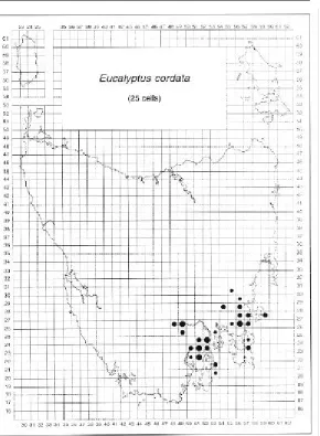
heart-leaved silver gum
Eucalyptus cordata is a rare endemic species
confined to south-eastern Tasmania (Figure 18). Small populations are scattered in two
disjunct areas representing relatively distinct morphs (Potts 1989) (Photo 7). They are centred around the Wellington Range to the west and the general vicinity of Prossers Sugarloaf in the east. Potts (1989) undertook a population survey to evaluate the genetic diversity of the species over its full ecological and geographic range as a basis for the development of a conservation strategy. Its distribution closely follows the south-eastern glacial refuge (sensu
Eucalyptus cordata
[image:23.595.238.528.133.528.2]SUBGENUS: Symphyomyrtus SERIES: Viminales
Figure 18. Distribution of E. cordata in Tasmania.
Davies 1974) and the small, scattered, insular populations, frequently comprising suppressed individuals, are consistent with this relict pattern and are vulnerable to disturbance.
Eucalyptus cordata is usually associated with
Figure 20. Flowering times for E. cordata. n = 193 Figure 19. Altitude distribution of E. cordata.
n = 67 Eucalyptus cordata occurs from near sea-level to 680 m but is most often found between 200 m and 600 m (Figure 19). The eastern morph generally occurs at the lower altitudes (100–400 m) and the western morph is associated with subalpine habitats (400– 680 m). The highest altitude occurrences are known from Herringback and Mundys Hills, east of Huonville. Eucalyptus cordata generally flowers from May to November (Figure 20) and exhibits a bimodal pattern which appears to be associated with the two morphs. The main flowering period of the eastern morph appears to be April to July (peaking in autumn) and, for the western morph, from September to November. However, more population-specific data are required to clarify this pattern.
Eucalyptus cordata rarely forms pure stands,
known exceptions being found at the summit of Perpendicular Mountain on Maria Island in the east, on the exposed, dry cliff scarp on Cape Queen Elizabeth and Penguin Island off Fluted Cape (Bruny Island), and in wet forest at Moogara to the west. In the east,
E. cordata usually occurs as a stunted mallee
shrub, scattered in the understorey of dry, open, lowland woodland dominated by
E. pulchella, with occasional E. globulus.
Photo 8. Regeneration of E. cordata (western morph) locally dominating a site adjacent to E. delegatensis forest.
However, with increasing altitude and rainfall to the west of its range, there is a shift towards greater cover and site dominance by
E. cordata, and co-occurrence with species
more commonly associated with wetter (e.g.
E. obliqua, E. regnans) or subalpine habitats
(e.g. E. delegatensis, E. coccifera, E. johnstonii,
E. urnigera) (Photo 8). In these wetter
regions, E. cordata can achieve a tree habit and frequently replaces the surrounding eucalypt species on the poorer drained sites dominated by the sedge Gahnia grandis. The persistent, highly glaucous, cordate juvenile foliage of E. cordata is a distinctive feature for which the species is widely planted as an ornamental.
COMMENTS: The distribution of E. cordata was verified by Potts (1988, 1989), and locations that were more recently discovered fall within this domain. Putative locations of the eastern morph (cells 5427, 5527) suggested by Brown et al. (1983) were not verified. A hybrid swarm in the vicinity of Meredith Tier
(cells 5732, 5733) was believed to involve
E. cordata, but a recent study (McEntee et al.
1994) indicates that glaucous morphs in this population may be related to E. gunnii. Persistent reports of E. cordata on Big Marsh near Platform Peak (cell 5027) and on Tasman Peninsula (cells 5622, 5721) also need field checking. The herbarium specimen from the former location may be juvenile E. urnigera. There is a verified population of E. cordata on Penguin Island (cell 5320, Potts 1988) off Fluted Cape, which is the type locality and represents the lowest altitude record (20– 40 m) for the species. A large stand of tall trees of the western morph of E. cordata, occurring with E. regnans, has recently been found near Moogara (cell 4926; C. Mitchell, pers. comm.). There are also reports from the northern foothills of Mount Wellington near Glenorchy (cells 5225, 5125, D. Ziegler, J. Kirkpatrick, pers. comm. 1996).
Eucalyptus dalrympleana subsp. dalrympleana
SUBGENUS: Symphyomyrtus SERIES: Viminales
Common name:
mountain white gum
Eucalyptus dalrympleana is widespread and
common on well-drained, upland slopes of the dolerite mountains and plateaux in northern, central, eastern and south-eastern regions (Figure 21). It intergrades clinally at lower altitudes with E. viminalis on the more fertile substrates such as Jurassic dolerite, and with E. rubida on dry, comparatively infertile, sedimentary substrates exposed to cold-air drainage. Intergradation with E. viminalis is more frequent than with E. rubida and has been studied by Phillips and Reid (1980). They found that clinal intermediates were
the most common form, with genetically based, continuous variation in several characters occurring between morphs known as E. viminalis or E. dalrympleana. This variation is most noticeable in the juvenile leaf shape which grades from long, thin, lanceolate leaves typical of south-eastern coastal E. viminalis, to broad, cordate leaves characteristic of inland, subalpine
E. dalrympleana. The morphs become more
distinct (fewer intermediates) with the northward trend in latitude and steeper environmental gradients.
Eucalyptus dalrympleana is a mid- to
high-altitude species generally occupying sites between 400 m and 800 m, and occasionally up to 1170 m (Figure 22). The lower altitude occurrences (150–400 m) are associated with cool, moist habitats, generally along the northern margins of its range, where intermediate forms become blurred in identity with E. viminalis. The highest altitude records are known from the Lake River catchment, east of Arthurs Lake on the Central Plateau. The main flowering period is from March to May, peaking in March and April (Figure 23).
Eucalyptus dalrympleana rarely forms pure
stands but is known to dominate small
patches of forest in the north-eastern high-lands. It is more commonly a subdominant or minor species in upland shrubby, wet and dry sclerophyll forests. In the wet forests, it usually occurs with E. delegatensis and, in the dry forests, E. pauciflora or E. amygdalina are frequent dominants.
COMMENTS: In Tasmania, E. dalrympleana is known to be phenotypically distinct from its mainland counterpart (Barber 1955; Pryor and Johnson 1971), and Barber (1955) applied the term 'vim-dal' to refer to intermediates between E. dalrympleana of the Australian mainland and E. viminalis (Phillips and Reid 1980). However, the term is widely applied by Tasmanian observers in reference to the uncertain identity of the frequent clinal intermediates between E. viminalis and
E. dalrympleana.
The distinction between E. viminalis,
E. dalrympleana and E. rubida becomes obscure
at altitudes between 200 m and 600 m, where the various clinal intermediates are not easy to classify. Low-altitude outliers (i.e. < 150 m) that were not verified were considered misidentifications of intergrading forms of
E. viminalis (e.g. cell 4343). In the west,
unverified outliers of E. dalrympleana are recorded near Strahan (cell 3633) and Waterfall Creek (cell 3830), and these same populations appear to have been ascribed to
E. viminalis by some observers. In the
north-east, unverified outliers are recorded for Mount Cameron (cells 5746, 5846), west of Mount Horror (cell 5545) and near Goulds Country (cell 5944). No verified occurrences are recorded on Maria Island, although Jackson (1965) indicates the presence of
E. dalrympleana there (e.g. cell 5927). In the
south-east, unverified outliers are recorded from near Balts Spur (cell 5723) and elsewhere on Tasman Peninsula (cells 5523, 5622). Other unverified outliers in southern Tasmania (cells 4918, 5019) are more doubtful.
KEY REFERENCES: Austin et al. (1983); Battaglia (1990b); Phillips and Reid (1980); Valentini et al. (1990).
Figure 23. Flowering times for E. dalrympleana. Figure 22. Altitude distribution of E. dalrympleana.
n = 596
Eucalyptus delegatensis subsp. tasmaniensis
SUBGENUS: Monocalyptus SERIES: Piperitae
Common name:
gum-topped stringy bark, white-top
Eucalyptus delegatensis subsp. tasmaniensis is a
widespread and common endemic subspecies found throughout Tasmania (Figure 24), replacing E. obliqua and E. regnans in the highland regions on comparatively fertile, moist, well-drained sites. It is generally absent from the oligotrophic environments of the far west and south-west, and it is not known from the Bass Strait islands.
Eucalyptus delegatensis most typically occurs at
altitudes between 400 m and 900 m (Figure 25), the upper and lower limits depending on the
Figure 24. Distribution of E. delegatensis in Tasmania.
Figure 26. Flowering times for E. delegatensis.
storeys vary from rainforest to mesophytic shrubs. On the moist ridges, plateaux and slopes of the Eastern Tiers and south-eastern Central Plateau, a shrubby or grassy dry sclerophyll understorey develops in open forest. Open forest gives way to woodland in subalpine climates and in the drier regions of undulating country on the upland margins of the Midlands and Derwent Valley. Eucalyptus
delegatensis frequently forms pure stands in
wet forests but may co-exist ecotonally with
E. obliqua at lower altitudes, with E. regnans
on the more fertile sites, or with E. amygdalina as moisture availability decreases. In subalpine situations closer to the tree-line, it may co-exist with E. coccifera, or with E. pauciflora in the inverted tree-line near the margin of frost hollows (Jackson 1973). Typical minor or subdominant species which co-occur with
E. delegatensis include E. dalrympleana at higher
altitudes or E. viminalis at lower altitudes.
COMMENTS: In the far north-west, scattered records of E. delegatensis (i.e. cells 3143, 3341, 3344, 3442) may be indicative of other western locations that are currently considered
unverified outliers (i.e. cells 3548, 3631, 3633, 3724). Western, low-altitude occurrences are recorded from the Heemskirk River region (cells 3536, 3537) and Cumberland Hill (cell 3435), and eastern, low-altitude occurrences are known from Mount Pearson near
St Helens (373 m, cell 6043), which is exposed to the prevailing weather of the north-east.
Many of the southern coastal forms of E. obliqua (e.g. see cells 4517, 4717 in Figure 43) appear similar to E. delegatensis, with rough stem bark and smooth branches but are otherwise morphologically true to E. obliqua (F. Duncan, pers. comm. 1994). Occasional hybrids between E. obliqua and E. regnans in the Southern Forests (e.g. Lune River to Cockle Creek, cells 4818, 4819) and Tasman Peninsula (e.g. cell 5722) are sometimes incorrectly ascribed to E. delegatensis (M.J. Brown, pers. comm. 1994). Such hybrids may also account for some of the low-altitude, unverified outliers in the north (e.g. cell 3945, 5145) and other low-altitude occurrences recorded here for E. delegatensis (Figure 25).
to north-east trend in the upper and lower altitude limits of E. delegatensis parallels the observations for the alpine tree-line in Tasmania (see Kirkpatrick 1982). However,
E. delegatensis is also recorded at relatively
low altitudes (150–400 m) along the northern margins of its range, consistent with similar low altitude occurrences of E. dalrympleana. The main flowering period is from January to March, peaking in January and February (Figure 26).
Eucalyptus delegatensis (Figure 27) dominates
a range of community types and is strongly associated with substrates derived from Jurassic dolerite, which are typically free-draining and have a high surface-rock cover. In upland tall, wet forest, such as in the north-eastern highlands and Western Tiers,
under-Figure 25. Altitude distribution of E. delegatensis. n = 2744
Ellis et al. (1985, 1987); Grose (1963); Hallam and Reid (1989); Hallam et al. (1989); Keenan and Candy (1983); Moran and Brown (1980); Moran et al. (1990); Nunez and Bowman (1986); Ohmart et al. (1984); Pederick (1990); Raymond (1994).
[image:30.595.76.499.241.640.2]KEY REFERENCES: Battaglia (1990a, 1993a, b); Battaglia and Reid (1993a, b); Battaglia and Wilson (1990); Boland (1985); Boland and Dunn (1985); Bowman (1986); Bowman and Kirkpatrick (1984, 1986a, b, c); Davidson and Reid (1985, 1987, 1989); Davidson et al. (1987);
Eucalyptus globulus subsp. globulus
SUBGENUS: Symphyomyrtus SERIES: Viminales
Common name: blue gum
Populations of E. globulus with multiple fruit per umbel which have been previously classified as E. globulus subsp. pseudoglobulus (Buchanan 1995) or E. bicostata (Curtis and Morris 1975; Chippendale 1988) are included here with E. globulus subsp. globulus (after Jordan et al. 1993). On capsule morphology, populations of E. globulus on the west coast and northern Flinders Island are intermediate between E. globulus subsp. globulus and the mainland E. globulus subsp. pseudoglobulus (Kirkpatrick 1975b; Jordan et al. 1993; Potts and Jordan 1994b). Similar intermediates are
also found in Victoria (e.g. Otway Ranges and south Gippsland; Jordan et al. 1993). However, the morphologically intergrading populations on northern Flinders Island are not markedly differentiated from other populations on Flinders Island on the basis of molecular markers (Nesbitt et al. 1995), growth response (Potts and Jordan 1994a), or juvenile leaf morphology (Potts and Jordan 1994b).
Eucalyptus globulus is widespread in
[image:31.595.91.525.132.550.2]predominantly coastal and near-coastal Figure 28. Distribution of
Figure 30. Flowering times for E. globulus.
in eastern Tasmania (Figure 30). More information is needed to define the flowering period of the western populations (including King Island) which consistently flower later than eastern populations in field trials (Gore and Potts 1995).
Eucalyptus globulus is an occasional dominant
and frequent subdominant tree in wet and dry sclerophyll forests and woodlands. In wet sclerophyll forests, it occurs in the canopy with E. obliqua or E. regnans over tall shrub understoreys. In dry sclerophyll forests, E. globulus may form pure stands in grassy communities but, in heathy or shrubby communities, is frequently co-dominant with, or occurs as an occasional emergent above, the more common peppermint species (E. amygdalina, E. pulchella or E. tenuiramis). In exposed coastal situations, fully mature, stunted individuals of E. globulus with heights less than 1.5 m have been recorded from Maria Island (Brown and Bayly-Stark 1979a) and at Cape Tourville on Freycinet Peninsula (Chambers 1992). The transition from the dwarf habit on cliff edges to tall trees in nearby sheltered forest is associated with genetically based clinal variation (Chambers 1992; Dingle 1994).
COMMENTS: The distribution of E. globulus is well known due to extensive seed collecting from native stands throughout Tasmania, the Bass Strait islands and southern Victoria (Orme 1983b; Volker and Orme 1988).
Eucalyptus globulus is a fast-growing species
with relatively large flowers (Photo 9) that are easily manipulated in breeding studies, and it has become one of the most important species for pulpwood production in temperate regions throughout the world (Eldridge et al. 1993). The King Island provenance has been of interest to plant breeders but was cleared extensively in the last century for agriculture. Many of the remnant trees are relatively isolated and seed collected from them may be inbred (Potts and Jordan 1994a).
Some records of E. globulus from the
Midlands, and north and north-east coasts are considered spurious and may reflect roadside situations of lowland eastern and
south-eastern Tasmania and the Bass Strait islands (Figure 28). It occupies a range of substrates, from the undulating country and fertile wet gullies of the generally seaward foothills and tiers, to the infertile, dry dune sands and sea cliffs of the coast. There are scattered populations of E. globulus along the west coast, and inland extensions in the Midlands and associated eastward valley systems.
Eucalyptus globulus is a lowland species
occurring from near sea-level to about 650 m and up to 830 m, but is typically found below 400 m (Figure 29). Most of the higher altitude occurrences are known from the vicinity of the Eastern Tiers and north of the Fingal Valley. Its main flowering period is September to December, peaking in October and November
Figure 29. Altitude distribution of E. globulus. n = 1143
introductions or forest plantation sites (e.g. cells 5141, 5240, 5243, 5244, 5341, 5445, 5745). However, a recently reported, although unverified, occurrence may extend the north-eastern distribution towards Gladstone (cells 5745, 5846) and a rare, high-altitude outlier (830 m) is recorded from the north-east (F. Duncan, unpublished data). Marginal unverified records in the southern Midlands (e.g. cells 4928, 4728, 5432) may reflect actual occurrences but require field investigation.
The west coast populations of E. globulus are markedly differentiated from east coast populations and these scattered, disjunct occurrences are of particular biogeographic interest (Jordan et al. 1993; Potts and Jordan 1994a). Genetic studies of the relative affinities of the eastern and western populations may ultimately indicate likely directions of migration between Tasmania and Victoria. Putative locations near Sandy Cape (cells 3140, 3142) indicated by Jackson
(1965) are possible but have remained unverified despite persistent searches. Anecdotal rumours of the Port Davey
population of E. globulus having been planted by early European settlers at Whalers Cove are unlikely as this population is relatively distinct and appears to contain advanced generation hybrids with a series Ovatae species (Potts and Jordan 1994a).
KEY REFERENCES: Battaglia et al. (1995); Eldridge and Griffin (1990); Farrow et al. (1994); Gore et al. (1990); Griffin (1993); Hallam et al. (1989); Hardner and Potts (1995a); Jordan et al. (1993, 1994); Kirkpatrick (1971, 1974, 1975a, b); Kirkpatrick et al. (1973); McAulay (1937); Metcalfe et al. (1991); Nesbitt et al. (1994, 1995); Orme (1983b); Paton (1980); Potts and Jordan (1994a, b); Potts and Marsden-Smedley (1989); Potts and Savva (1989); Rhizopoulou and Davies (1993); Scarascia-Mugnozza et al. (1989); Tibbits (1986a); Volker and Orme (1988); Volker et al. (1990, 1994); West (1981).
Eucalyptus gunnii
SUBGENUS: Symphyomyrtus SERIES: Viminales
Common name: cider gum
Eucalyptus gunnii is an endemic subalpine
species growing on poorly drained, frost-prone plateaux, flats and hollows. It occurs in north-western, central and north-eastern highland regions, and in disjunct habitats of the Eastern Tiers and the southern dolerite mountains (Figure 31). Eucalyptus gunnii and
E. archeri clinally intergrade on the Central
Plateau along the north–south gradient in rainfall and frost severity, but occupy spatially separate habitats in the north-eastern mountains. In the alpine plateau environment, an east–west gradient in
[image:34.595.177.513.135.530.2]exposure results in the clinal transition between 'divaricata' and 'southern gunnii' morphs of E. gunnii (Potts and Reid 1985a; Potts 1985). The 'divaricata' morph, distinguished as a species by Brett (1938, i.e. E. divaricata McAulay and Brett) is now treated as a minor variant of E. gunnii (Pryor and Johnson 1971; Potts and Reid 1985a). Potts and Reid (1985a) summarised the variation in the E. gunnii–archeri complex into five morphs, corresponding to the cline from green to waxy glaucousness (Barber 1955), which is the main taxonomic character used Figure 31. Distribution of
Figure 33. Flowering times for E. gunnii.
with various shrub and rainforest under-storeys, or co-exist with other subalpine eucalypts such as E. delegatensis, E. coccifera or E. dalrympleana. Eucalyptus gunnii and
E. urnigera are closely related taxa that may
co-occur on the southern Central Plateau but, in the south-east (e.g. Snug Plains), they are ecologically separate. The small southern and far north-western populations of E. gunnii occur at relatively low altitudes where they are associated with buttongrass plains and tussock grassland respectively (Potts and Reid 1985a). Relict patches of E. gunnii have also been found within closed riparian scrub at relatively low altitudes (500 m) in the Eastern Tiers (Askey-Doran 1993). Eucalyptus
gunnii frequently forms large plate
lignotubers which survive aerial defoliation due to extreme frost or fire and resprout vigorously. The ability to coppice from an underground lignotuber following adversity has enabled some individuals to exhibit unusual longevity (Head and Lacey 1988).
Eucalyptus gunnii is one of the most frost
tolerant eucalypts (Hooker 1844; Barber 1955; Marien 1979) and is the subject of a breeding program to develop frost resistant clones for eucalypt plantation establishment in France (Cauvin 1983; Cauvin and Potts 1991). Some populations of E. gunnii are known for the production of a sugary sap from the trunk that was reputedly used by the local Aboriginal community for the production of an alcoholic drink, and hence the common name of 'cider gum' (e.g. Ellis 1973). The attractive juvenile leaf of the coppice foliage has also led to its widespread use by florists.
COMMENTS: The intergradation between
E. gunnii and E. archeri leads to some
difficulties in field identification of the two species. In addition, both E. gunnii and
E. archeri may be present in the same grid
cell, but occupying separate habitats. For example, in the north-eastern highlands,
E. gunnii occurs on Mount Arthur (cell 5242)
and Mount Victoria (cells 5642, 5742), whilst
E. archeri occurs on the other nearby
mountains, and both species are recorded from near Ben Nevis (cell 5541). Additional in distinguishing E. gunnii and E. archeri
(Curtis and Morris 1975).
Eucalyptus gunnii is generally found above
800 m in the inverted tree-lines on the Central Plateau, and more widely (500–1200 m) in the north-east (Figure 32). However, relict populations generally occur at lower altitudes (330–740 m) in the east, south-east and far north-west where poorly drained sites are locally subject to frost and cold-air pooling. The main flowering period is from November to March, peaking from December to
February (Figure 33).
Eucalyptus gunnii (Photo 10) most typically
dominates grassy and sedgey open forest and woodlands. In restricted situations at lower altitudes, it may dominate montane tall forest
n = 448 Figure 32. Altitude distribution of E. gunnii.