Satellite remote sensing of ecosystem functions:
opportunities, challenges and way forward
Nathalie Pettorelli1, Henrike Schulte to Buhne€ 1, Ayesha Tulloch2, Gregoire Dubois3,
Cate Macinnis-Ng4, Ana M. Queiros 5, David A. Keith6,7,8, Martin Wegmann9, Franziska Schrodt10, Marion Stellmes11, Ruth Sonnenschein12, Gary N. Geller13,14, Shovonlal Roy15, Ben Somers16, Nicholas Murray6, Lucie Bland17, Ilse Geijzendorffer18, Jeremy T. Kerr19, Stefanie Broszeit5, Pedro J. Leit~ao20,21, Clare Duncan17, Ghada El Serafy22, Kate S. He23, Julia L. Blanchard24, Richard Lucas25, Paola Mairota26, Thomas J. Webb27 & Emily Nicholson17
1Institute of Zoology, Zoological Society of London, Regent’s Park, NW1 4RY London, UK
2School of Earth and Environmental Sciences, University of Queensland, Brisbane, 4072 Qld., Australia
3European Commission, Joint Research Centre (JRC), Directorate D–Sustainable Resources, via E. Fermi 2749, I-21027 Ispra, VA, Italy 4School of Biological Sciences, University of Auckland, Private Bag 92019, Auckland 1142, New Zealand
5Plymouth Marine Laboratory, Prospect Place, PL1 3Dh Plymouth, UK
6Centre for Ecosystem Science, School of Biological, Earth and Environmental Science, University of New South Wales, Kensington, NSW 2052,
Australia
7NSW Office of Environment and Heritage, Hurstville, NSW 2220, Australia 8
Long Term Ecological Research Network, Terrestrial Ecosystem Research Network, Australian National University, Canberra, ACT 0200, Australia
9Department of Remote Sensing, Ecology and Conservation Research, Institute of Geography and Geology, University of W€urzburg, W€
urzburg, Germany
10School of Geography, University of Nottingham, Nottingham NG7 2RD, UK
11Remote Sensing and Geoinformatics, Institute of Geographical Sciences, Freie Universit€at Berlin, Malteserstraße 74-100, 12249 Berlin, Germany 12Institute for Earth Observation, Eurac Research, Viale Druso 1, Bolzano, Italy
13Group on Earth Observations (GEO), Geneva, Switzerland
14NASA Jet Propulsion Laboratory, California Institute of Technology, Pasadena, CA, USA
15Department of Geography and Environmental Science & School of Agriculture, Policy and Development, University of Reading, Whiteknights,
Reading RG6 6AB, UK
16Division Forest, Nature and Landscape, KU Leuven, Celestijnenlaan 200E, 3001 Heverlee, Belgium
17Centre for Integrative Ecology, School of Life and Environmental Sciences, Deakin University, Burwood, Vic. 3121, Australia 18Institut de recherche pour la conservation des zones humides mediterraneennes, Le Sambuc, 13 200 Arles, France 19Department of Biology, University of Ottawa, Ottawa, ON K1N6N5, Canada
20Department Landscape Ecology and Environmental System Analysis, Institute of Geoecology, Technische Universit€at Braunschweig, Langer Kamp
19c, D-38106 Braunschweig, Germany
21Geography Department, Humboldt-Universit€at zu Berlin, Unter den Linden 6, D-10099 Berlin, Germany 22
Marine and Coastal Systems, Deltares, Rotterdamseweg 185, PO Box 177, 2600 MH Delft, The Netherlands
23
Department of Biological Sciences, Murray State University, Murray, KY, USA
24
Institute for Marine and Antarctic Studies and Centre for Marine Socioecology, University of Tasmania, 20 Castray Esplanade, Hobart, Tas., Australia
25Centre for Ecosystem Science (CES), School of Biological, Earth and Environmental Science (BEES), The University of New South Wales (UNSW),
High Street, Kensington, NSW, Australia
26Department of Agro-Environmental and Territorial Sciences, University of Bari, “Aldo Moro”, Via Orabona 4, 70125 Bari, Italy 27Department of Animal & Plant Sciences, University of Sheffield, Sheffield S10 2TN, UK
Keywords
Biodiversity loss, biodiversity monitoring, ecosystem functions, ecosystem services, satellite remote sensing
Correspondence
Nathalie Pettorelli, Institute of Zoology, Zoological Society of London, Regent’s Park, NW1 4RY London, UK. Tel: +44 (0)207 449 6334; E-mail: [email protected]
Abstract
Editor: Marcus Rowcliffe Associate Editor: Mat Disney
Received: 3 April 2017; Revised: 19 May 2017; Accepted: 23 June 2017
doi: 10.1002/rse2.59
ecosystem functions are and how to track them at scales beyond the site level. This contribution aims to advance the development of a global biodi-versity monitoring strategy by proposing the adoption of a set of definitions and a typology for ecosystem functions, and reviewing current opportunities and potential limitations for satellite remote sensing technology to support the monitoring of ecosystem functions worldwide. By clearly defining ecosys-tem processes, functions and services and their interrelationships, we provide a framework to improve communication between ecologists, land and marine managers, remote sensing specialists and policy makers, thereby addressing a major barrier in the field.
Introduction
Biodiversity is in crisis, as wildlife populations decline (McCauley et al. 2015; WWF Living Planet Report 2016), species extinction rates surge (Ceballos et al. 2015; Alroy 2015; Webb and Mindel 2015), and ecosystems fragment, degrade and collapse (Valiela et al. 2001; Hansen et al. 2013). To halt further depletion of the Earth’s biological diversity and avoid detrimental impacts on human well-being (Millennium Ecosystem Assessment 2005), there is an urgent need not only to improve our ability to track changes in biodiversity and the pressures affecting it (Hal-pern et al. 2008; Pettorelli et al. 2014), but also to further our understanding of the relationships between biodiver-sity and ecosystem services (Geijzendorffer and Roche 2013; Harrison et al. 2014). Key to elucidating the mecha-nisms through which biological diversity generates ser-vices to humans is the concept of ecosystem functions (Duncan et al. 2015).
What ecosystem functions are and how they relate to biodiversity has been subjects of debate for decades, due partly to much confusion over definitions (Paterson et al. 2012; Roe et al. 2013). Biodiversity, as defined in the seminal paper by Noss (1990), possesses three primary attributes – composition, structure, and function– which can be tracked at multiple levels of biological organiza-tion, from ecosystem to population/species and genetic. This definition, which underpins the definition adopted by the United Nations Convention on Biological Diversity (CBD), makes it clear that biodiversity is a fundamentally multidimensional concept that includes ecosystem func-tions (Culman et al. 2010).
Interestingly, ecosystem functions are rarely measured, particularly over large areas, with biodiversity monitoring as a whole having historically been primarily based on structural and compositional features of the observed sys-tems, rather than functional features (Callicott et al. 1999; Magurran 2004; Schroter et al. 2016). Past attempts to€ measure ecosystem functions have indeed been primarily undertaken at relatively small spatial extents, and can be grouped into four broad categories, namely: (i)
proxy-based monitoring proxy-based on population and species data (Drever et al. 2008; Kehinde and Samways 2012), (ii) process-based monitoring (such as using primary produc-tivity to track changes in pollination; Werling et al. 2014), (iii) proxy-based monitoring based on genetic information (such as determining functional connectivity of populations; Braunisch et al. 2010) and (iv) trait-based monitoring [assuming either that high trait or functional diversity is a proxy for good ecosystem functioning (see e.g. Moretti and Legg 2009) or that dominant trait values determine the rates of functions (see e.g. Queiros et al. 2013; Solan et al. 2004)]. Most ecosystem assessments and conservation efforts then fail to account for functions due to a perceived lack of adequate spatial data to map these features (Tulloch et al. 2016), instead relying on species and structural data as surrogates for processes.
This reliance on compositional and structural features to track changes in ecosystem functions, as well as the current inability to map multiple functions across broad scales not only hampers our ability to expand our under-standing of biodiversity-ecosystem services relationships, but also hinders the development of conservation man-agement strategies (e.g. no-net loss strategies), impairs environmental impact assessments and limits our compre-hension of what sustainable development should take into consideration (Fuhlendorf et al. 2006; Kollmann et al. 2016). Ecosystem functions may indeed sometimes respond more quickly to environmental change than structural or compositional attributes (McNaughton et al. 1989; Milchunas and Lauenroth 1995), and as such, could be among the most sensitive indicators of change when monitoring ecosystems globally (Daily et al. 2009; Haines-Young et al. 2012; Koschke et al. 2012).
explicitly refer to the monitoring of ecosystem function-ing (Keith et al. 2015). However, assessments undertaken thus far have highlighted the relative lack of data on ecosystem functioning, with 50% of them not assessing functional criteria (L. Bland, pers. comm.). In parallel to this, the Group on Earth Observations – Biodiversity Observation Network (GEO BON) developed a frame-work for biodiversity monitoring based on the concept of essential biodiversity variables (EBVs) (Pereira et al. 2013), which includes a class for ecosystem functions. However, so far no scientific consensus has been reached on what exactly ecosystem functions are and how to track them at scales beyond the site level; this lack of clarity has hampered progress in terms of identifying opportuni-ties for ecosystem function monitoring globally.
To address these gaps, we propose the adoption of a set of definitions and typology for ecosystem functions relevant to both terrestrial and marine ecologists, build-ing on previous efforts to identify and monitor ecosystem functions (Petter et al. 2012; Meyer et al. 2015). Because satellite remote sensing is the only methodology currently able to provide global coverage and continuous measures across space at relatively high spatial and temporal reso-lutions (Skidmore et al. 2015; Pettorelli et al. 2016), we subsequently provide an up-to-date perspective on the current and future prospects of satellite remote sensing for monitoring ecosystem functions in both the terrestrial and marine realms, reviewing established products, high-lighting new developments that have the greatest poten-tial to make a difference to practitioners and policy makers, and discussing potential limitations. We con-clude by stressing opportunities for the proposed moni-toring framework to inform relevant global policy initiatives.
Agreeing on What Ecosystem
Functions Are
Ecosystem processes, ecosystem functions and ecosystem services
Ecosystem functions mean different things to different people. Multiple definitions of ecosystem functions can indeed be found in the literature and the term is often used synonymously with ecosystem services (Srivastava and Vellend 2005; Lamarque et al. 2011), ecological pro-cesses (Lawton and Brown 1993) and ecosystem propro-cesses (Dominati et al. 2010; Mace et al. 2012; see Table 1). Yet without agreement on what ecosystem functions are (Table 1), progress on our ability to monitor them is likely to be slow and erratic.
To help identify an implementable framework for the monitoring of ecosystem functions globally, we here
suggest adopting the following definitions of ecological processes, ecosystem processes, ecosystem functions and ecosystem services, which are applicable across all ecologi-cal realms and integrate these concepts into a common framework consistent with Noss’ (1990) definition of bio-diversity (Fig. 1). Specifically, we considered three criteria to select appropriate definitions of these terms, namely (i) the proposed definitions should clearly separate functional and structural/compositional properties of ecosystems; (ii) they should clearly distinguish between organism- and ecosystem-level properties; and (iii) they must allow inte-grating all concepts (i.e. ecological processes, ecosystem processes, ecosystem functions and ecosystem services) in a common framework.
An overview of existing definitions of ecological pro-cesses, ecosystem propro-cesses, ecosystem functions and ecosystem services are provided in Table 1, together with the rationale behind retaining or rejecting a given defini-tion. Based on this approach, we here define ecological
processes as activities that result from interactions among
Table 1. Coexisting definitions pertinent to the concepts of ecological processes, ecosystem processes, ecosystem functions and ecosystem services.
Concept Definition Reference Benefit/Drawback
Ecological processes
Activities that result from interactions among organisms and between organisms and their environment
Martinez (1996) This definition separates organism level processes from ecosystem level processes
An interaction among organisms; ecological processes frequently regulate the dynamics of ecosystems and the structure and dynamics of biological communities
Mace et al. (2012) Incomplete: ecological processes should also include interactions between organism and their abiotic environment, since these have an important impact on organism-level attributes (such as survival)
Ecosystem processes
Transfer of energy, material, or organisms among pools in an ecosystem
Lovettet al.(2006) Clearly excludes organism-level processes; does not refer to stocks of materials Complex physical and biological cycles and interactions
that underlie what we observe as the natural world
Brown et al. (2007) Vague; fails to establish the distinction between ecological and ecosystem processes
Changes in the stocks and/or flows of materials in an ecosystem, resulting from interactions among organisms and with their physical–chemical environment
Mace et al. (2012) Fails to establish the distinction between ecological and ecosystem processes
Ecosystem functions
Refer variously to the habitat, biological or system properties or processes of ecosystems
Costanza et al. (1997) Vague: fails to establish the distinction between ecosystem functions and ecosystem processes Ecosystem processes and ecosystem stability Bengtsson (1998) Fails to establish the distinction between
ecosystem functions and ecosystem processes Stocks of energy and materials (e.g. biomass), fluxes of
energy or material processing (e.g. productivity, decomposition), and the stability of rates or stocks over time
Pacala and Kinzig (2002)
Subsumes ecosystem structure (‘stock’) under the concept of ‘function’; fails to establish the distinction between ecosystem functions and ecosystem processes
The capacity of natural processes and components to provide goods and services that satisfy human needs, directly or indirectly
De Groot et al. (2002) Fails to establish the distinction between ecosystem functions and ecosystem services
Attributes related to the performance of an ecosystem that is the consequence of one or of multiple ecosystem processes
Lovettet al.(2006) Explicitly relates the concept of ecosystem processes to ecosystem functions
The subset of the interactions between biophysical structures, biodiversity and ecosystem processes that underpin the capacity of an ecosystem to provide ecosystem services
Kumar (2010) Conflates structural and compositional attributes of biodiversity (‘stocks’) with functional aspects (‘fluxes’)
The ecological processes that control the fluxes of energy, nutrients and organic matter through an environment
Cardinale et al. (2012) Fails to establish the distinction between ecosystem processes, ecological processes and ecosystem functions
The energy, matter, and information fluxes linking ecosystem compartments
Meyer et al. (2015) Fails to establish the distinction between ecosystem processes and ecosystem functions The biological underpinning of ecosystem services Oliver et al. (2015) Vague; does not clearly separate function from
structure Ecosystem
services
The conditions and processes through which natural ecosystems, and the species that make them up, sustain and fulfil human life
Daily (1997) Vague; the relationship between ecosystem functions and services is unclear
The benefits human populations derive, directly or indirectly, from ecosystem functions
Costanzaet al.(1997) Provides a clear link to ecosystem functions
The benefits people derive from ecosystems Millennium Ecosystem Assessment (2005)
Vague; the relationship between ecosystem functions and services is unclear Ecosystem services are the aspects of the ecosystems
utilized (actively or passively) to produce human well-being
Fisher et al. 2009 Vague; the relationship between ecosystem functions and services is unclear
Direct and indirect contributions of ecosystems to human well-being
TEEB (2010) Vague; the relationship between ecosystem functions and services is unclear
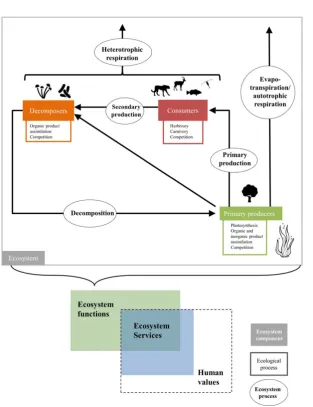
Figure 1. Simplified representation of the links between ecological processes, ecosystem processes, ecosystem functions and ecosystem services. Decomposers, consumers and primary producers represent the main pools of a given ecosystem. Ecological processes mostly occur within each pool; examples of ecological processes are listed under each pool. Ecosystem processes capture the transfer of energy, material, or organisms among pools; examples of ecosystem processes appear in circles. Ecosystem functions represent attributes related to the performance of an ecosystem; they are the consequence of one or of multiple ecosystem processes. Finally, ecosystem services are those elements of ecosystem functions that benefit people.
Table 1. Continued.
Concept Definition Reference Benefit/Drawback
Outputs of ecosystem processes that provide benefits to humans (e.g. crop and timber production)
Oliver et al. (2015) The relationship between ecosystem functions and services is unclear
Those functions and products of an ecosystem that directly or indirectly benefit humans. Often ecosystem functions are considered a service when they can be attributed an economical value
Meyer et al. (2015) Definition not as well-known as that of Costanza et al. 1997, but does not contradict it
Introducing a typology of ecosystem functions
Although the concept of ecosystem function is not new (Odum 1969), only recently have attempts been made to identify and classify ecosystem functions. The first attempt to comprehensively identify and classify ecosys-tem functions can be traced to de Groot and colleagues in 2002; their list has been used by many as a starting point for establishing monitoring protocols for ecosystem functions and ecosystem services (see e.g. Wallace 2007; Petter et al. 2012). The main issue with this original clas-sification is the confusion between ecosystem functions and ecosystem services, which led de Groot and colleagues to include ‘information functions’, such as aesthetic infor-mation, recreation, cultural and artistic inforinfor-mation, spir-itual and historic information, as well as science and education, in their typology of ecosystem functions. De Groot et al.’s typology was later refined by others, includ-ing Petter et al. (2012), who identified 19 terrestrial ecosystem functions. This typology is particularly relevant to developing an implementable global monitoring frame-work for ecosystem functions, as it was used by the authors to map these individual functions for the South East Queensland region in Australia. However, it does mention the existence of a cultural function, which reflects the interests of the authors in using ecosystem function mapping as a way to derive information about spatial variation in ecosystem services for this region. Because this cultural function was clearly based on anthropocentric values, it does not fit our definition of ecosystem functions. In the marine realm, typologies of ecosystem functions are also rarely discussed. One excep-tion is the work by Boero and Bonsdorff (2007) who dis-tinguished three broad groups of functions based on basic cycles of matter and energy, namely (i) extraspecific cycles (biogeochemical cycles), (ii) intraspecific cycles (life cycles and histories), and (iii) interspecific cycles (food webs). However, their definition of ecosystem functions does not distinguish between organism- and ecosystem-level pro-cesses.
We here propose a new ecosystem function typology, which broadens the definitions of the candidate functions identified by Petter and colleagues in 2012, making them relevant to all ecological realms. This new typology lines up with the widely accepted Millennium Ecosystem Assessment typology for ecosystem services (MEA 2005), thus allowing clear links between the two frameworks. Because we vetted our list against Lovett et al. (2006)’s definition of ecosystem functions (Table 2), our proposed typology excludes cultural functions (as they are ecosys-tem services), and thus only distinguishes 18 ecosysecosys-tem functions, which are all shaped by different ecological and
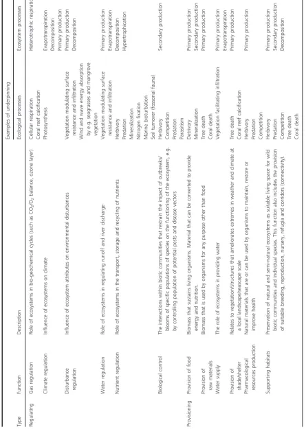
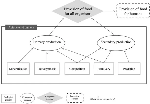
ecosystem processes (Table 2). These 18 functions can be broadly classified into regulating functions (which control the magnitude of ecosystem processes, such as climate regulation and biological control), provisioning functions (which provide all organisms with the resources necessary for their survival and reproduction, such as water supply and provision of food), and supporting functions (which underpin the continued functioning of the ecosystem, such as the formation and retention of soil and sediment, and pollination/larval and seed dispersal). A definition of each of these functions, as well as examples of ecological and ecosystem processes that underpin the delivery of these functions can be found in Table 2 and Figure 2.
Satellite Remote Sensing of
Ecosystem Functions
Opportunities
A wealth of methods is currently available to monitor vari-ous ecosystem functions that rely on the collection of field data (Meyer et al. 2015); however, on their own, none can realistically be scaled up to reach global coverage on a regu-lar (daily, weekly, monthly) basis. For example, Steenweg et al. (2017) suggest a framework for global monitoring of biodiversity with large-scale camera networks but major limitations include inconsistent metadata, data access, intellectual property and privacy considerations. Satellite remote sensing measurements, on the other hand, are widely accessible, and offer a relatively inexpensive and ver-ifiable means of deriving complete spatial coverage of envi-ronmental information for large areas at different spatial and temporal resolutions in a consistent manner (Pettorelli et al. 2014), holding great potential for tracking changes in ecosystem functions (Cabello et al. 2012; Nagendra et al. 2013; Pettorelli 2013).
Table 2. Typology of ecosystem functions, with examples of ecological and ecosystem processes underpinning the delivery of a given function. Type Function Description Examples of underpinning Ecological processes Ecosystem processes Regulating Gas regulation Role of ecosystems in bio-geochemical cycles (such as CO 2 /O 2 balance, ozone layer) Cellular respiration Coral reef calcification Heterotrophic respiration Climate regulation Influence of ecosystems on climate Photosynthesis
Evapotranspiration Decomposition Primary
production Disturbance regulation Influence of ecosystem attributes on environmental disturbances Vegetation modulating surface resistance and infiltration Wind and wave energy absorption by e.g. seagrasses and mangrove vegetation Primary production Decomposition Water regulation Role of ecosystems in regulating runoff and river discharge Vegetation modulating surface resistance and infiltration Primary production Evapotranspiration Nutrient regulation Role of ecosystems in the transport, storage and recycling of nutrients
Herbivory Predation Mineralization Nitrogen
fixation Marine bioturbation Soil turnover (fossorial fauna) Decomposition Hypertrophication Biological control The interactions within biotic communities that restrain the impact of outbreaks/ blooms of specific populations of species on the functioning of the ecosystem, e.g. by controlling population of potential pests and disease vectors
Herbivory Competition Predation Parasitism
Secondary production Provisioning Provision of food Biomass that sustains living organisms. Material that can be converted to provide energy and nutrition. Detrivory Mineralization Primary production Secondary production Provision of raw materials Biomass that is used by organisms for any purpose other than food Tree death Coral death Primary production Water supply The role of ecosystems in providing water Vegetation facilitating infiltration Primary production Evapotranspiration Provision of shade/shelter Relates to vegetation/structures that ameliorates extremes in weather and climate at a local landscape/seascape scale Tree death Coral reef calcification Primary production Pharmacological resources production Natural materials that are or can be used by organisms to maintain, restore or improve health
Herbivory Predation Competition
Primary production Supporting habitats Preservation of natural and semi-natural ecosystems as suitable living space for wild biotic communities and individual species. This function also includes the provision of suitable breeding, reproduction, nursery, refugia and corridors (connectivity).
Herbivory Predation Competition Tree
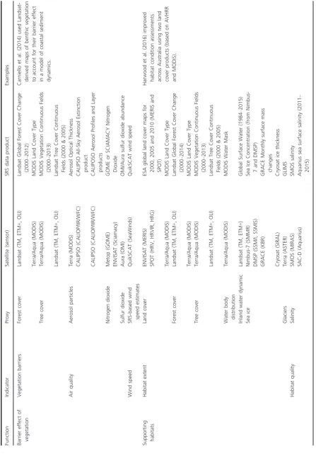
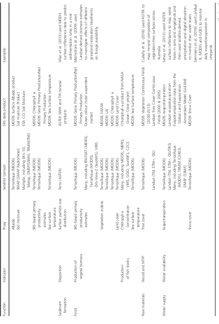
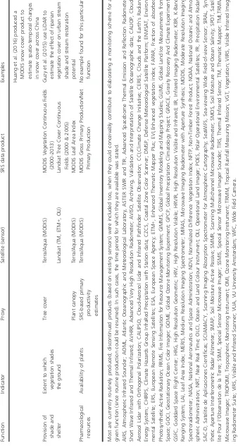
[image:7.595.66.512.77.713.2]effects of defaunation on tropical forest functions, allow-ing for more targeted field data collection and faster development and implementation of effective manage-ment actions (Osuri et al. 2016; Peres et al. 2016).
As with most conceptual frameworks that inform our understanding of the natural world (Stephens et al. 2015), ecosystem functions ultimately relate to entities that can be hard to measure directly and are the result of multiple ecosystem processes (Table 2; Fig. 2). Hence, the moni-toring a given ecosystem function will mostly depend on the tracking of many relevant indicators. Table 3 provides a non-exhaustive list of open-access satellite remote sens-ing products that could contribute to the dynamic, global monitoring of ecosystem functions: as one can see, a range of ecosystem function indicators is already well supported by existing products (Table 3). In addition, upcoming satellite missions will increase the level of detail and accuracy with which we can map ecosystem func-tions, as well as opening new monitoring opportunities (Table 4). The Sentinel missions in particular could become a game changer for comprehensive global ecosys-tem function monitoring, since they (i) carry a range of sensors relevant to land, ocean and atmospheric monitor-ing; (ii) provide the only global, open-access radar ima-gery (Sentinel 1); (iii) allow gathering data at both high temporal (5 days) and spatial resolutions (5–10 m). Future spaceborne hyperspectral sensor missions (such as the Environmental Mapping and Analysis Program (EnMAP), the Hyperspectral Infrared Imager (HyspIRI), and the Hyperspectral Precursor of the Application Mis-sion (PRISMA – Italian Space Agency) could moreover provide unprecedented opportunities to characterize sur-face chemistry and structure in great detail (Chambers et al. 2007). Data collected by these missions could indeed expand ecosystem monitoring capacity signifi-cantly, especially with regard to carbon and water vapour flux modelling (Fuentes et al. 2006), chemical composi-tion of foliage (Schlerf et al. 2010), early deteccomposi-tion of defoliators (Fassnacht et al. 2014), accurate mapping of burned areas (Veraverbeke et al. 2014), permafrost moni-toring (Buchhorn et al. 2013) and measurements of ecosystem methane emissions (Thompson et al. 2015), complementing the monitoring capacity of existing sen-sors (Guanter et al. 2015). Monitoring of biomass (Hyde et al. 2007; Nelson et al. 2007) and canopy structure (Vierling et al. 2008; Lefsky 2010; Enßle et al. 2014) are also likely to be facilitated by the availability of global LiDAR data from spaceborne missions (e.g. ICESat-2 and GEDI; Patterson and Healey 2015; Brown et al. 2016). Beyond new satellite missions, advances in data process-ing are also likely to expand ecosystem function monitor-ing capacities. For instance, image fusion techniques allow combining imagery with high spatial, low temporal
Table
2.
Continued.
Type
Function
Description
Examples
of
underpinning
Ecological
processes
Ecosystem
processes
Production
of
genetic
resources
Self-maintaining
diversity
of
organisms
developed
over
evolutionary
time
(capable
of
continuing
to
change)
Herbivory Predation Competition
Primary
production
Secondary
production
Supporting
Soil/sediment
retention
Role
of
vegetation
root
matrix
and
soil
biota
in
soil/sediment
retention
Root
zone
competition
Erosion
Primary
production
Waste
treatment
and
assimilation
Role
of
biota
in
transport,
storage
and
recycling
of
organic
and
inorganic
wastes
(defined
here
as
by-products
generated
by
a
given
set
of
organisms)
Organic
and
inorganic
product
assimilation
Filter
feeding
Decomposition Hypertrophication
Pollination/dispersal (of
seed
and
larvae)
Role
of
biota
in
movement
of
floral
gametes
and
seeds,
or
aquatic/marine
spores,
eggs
and
larvae
Predation Herbivory Nectarivory
Primary
production
Barrier
effect
of
vegetation/coral structures
Vegetation/structures
impedes
the
movement
of
airborne
and
waterborne
substances
such
as
particulate
matter,
dust
and
aerosols
(including
agricultural
chemicals
and
industrial
and
transport
emissions),
enhances
air
mixing
and
mitigates
noise
Coral
reef
calcification
Primary
production
Soil/Sediment
formation
Facilitation
of
soil/sediment
formation
processes
Biological
weathering
of
rocks
Sediment
trapping
Primary
production
[image:8.595.73.292.68.719.2]resolution (e.g. Landsat) and imagery with low spatial, high temporal resolution (e.g. MODIS) into time series with high spatial, high temporal resolution (Gao et al. 2006; Schmidt et al. 2015), which could support a better characterization of vegetation phenology.
Limitations
Monitoring ecosystem functions, using satellite data or ground-based information, first necessitates agreement on what ecosystem functions are, but also on what ecosys-tems are and where their boundaries lie (Likens 1992). Such difficulties are not limited to ecosystems, with simi-lar discussions arising when considering populations or species (see e.g. Mallet 1995; Berryman 2002). The Red List of Ecosystems offers a comprehensive framework for defining and monitoring ecosystems (Bland et al. 2016), and as such could be used as a reference point for agree-ing on where boundaries should be set. Doagree-ing so would allow complementarity and effectiveness in efforts to monitor, and report on, the state of ecosystems globally.
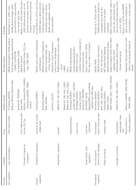
As demonstrated in Table 3, monitoring ecosystem function then involves making a number of choices in terms of which indicators and which proxies to consider; these choices may all have implications for the reliability of the inferred trends. Satellite remote sensing is more-over associated with intrinsic limitations, which have been discussed at length (see e.g. Pettorelli 2013; Pettorelli et al. 2014, 2016); one can thus expect data product
characteristics (spatial, temporal, spectral resolutions) to influence mapping accuracy and monitoring opportunities for certain ecosystem functions in certain environments. Integrated use of multiple remote sensing sources and increased remote sensing capacity can help overcome many of these known challenges, as long as data and pro-duct requirements are clearly identified: the prioritization of new satellite missions associated with freely accessible data for scientific use might indeed be facilitated by the formulation of clear, consensual demands from ecosystem researchers (Paganini et al. 2016).
[image:9.595.140.446.73.285.2]areas such as coastal waters and the seabed (Tilstone et al. 2017). Remote sensing products are moreover unlikely to fill all of the needs of conservation decision-makers, sci-entific research, and environmental assessment focused on tracking or improving ecosystem function, because these needs are defined at different spatial and temporal extents and resolutions, and come with differences in expecta-tions. Given that most data collected to track ecosystem functions will be surrogates (whether it be remotely-sensed, gathered through on-ground monitoring programs, or a combination of both), assessing and acknowledging the expected benefits and limitations of the measured quantity, in terms of accuracy, representa-tiveness, cost, and sensitivity will ultimately be key (Lin-denmayer et al. 2015).
The list of satellite remote sensing products relevant to monitoring ecosystem function is likely to change rapidly as efforts to integrate ecosystem function in ecosystem assessments increase, knowledge and technol-ogy advances, and costs of data access and processing diminish. Consequently, product users could struggle to maintain an up-to-date knowledge of available data and tools, and decide on how to best derive trends from datasets generated by sensors covering different periods and that have different specifications. To improve on the use of satellite remote sensing data to monitor ecosystem functions, and fully capitalize on current and future opportunities, will require the sharing of informa-tion between data providers, ecologists, ecosystem mod-ellers and remote sensing experts interested in ecosystem function monitoring. For this to happen, a clear and common platform for discussion and communication of data products urgently needs to be identified, with well-defined terminology, conceptual translation across disci-plines, provision for data sharing and version controls, and communication of the development and capabilities of relevant new technologies. To make such a platform a reality requires identifying who will take responsibility for (i) developing the platform; (ii) updating the infor-mation provided on a regular basis, (iii) managing and optimizing engagement with potential users and (iv) securing its viability in the long term. It also requires consistent and continuing funding being allocated to the development and maintenance of such a platform. Such interdisciplinary communication actions may benefit from lessons learned through similar efforts across these communities, e.g. ecosystem model development (Queiros et al. 2015).
The use of satellite remote sensing data to monitor ecosystem functions necessitates practical and/or theoreti-cal training, particularly related to ecology and the geo-physical sciences, as well as knowledge in remote sensing; yet few ecologists and conservation biologists typically
Table
4.
Continued.
Function
Indicator
Proxy
Satellite
(sensor)
SRS
data
product
Water
quality
SRS-based
estimates
of
water
quality
EnMAP
(VNIR/SWIR)
EnMAP
water
quality
and
availability
Provision
of
shade
and
shelter
Extent
to
which
vegetation
shades
the
ground
Tree
cover
Proba
V
(Vegetation)
Proba
V
Fraction
of
green
vegetation
Cover
Plant
canopy
Sentinel
2
(MSI)
Sentinel
2
Leaf
Area
Index
ASAR,
Advanced
Synthetic
Aperture
Radar;
ATLAS,
Advanced
Topographic
Laser
Altimeter
System;
CCI,
Climate
Change
Initiative;
CERES,
Clouds
and
th
e
Earth’s
Radiant
Energy
System;
EnMAP,
Environmental
Mapping
and
Analysis
Program;
ENVISAT,
Environmental
Satellite;
ESA,
European
Space
Agency;
ETM
+
,
Enhanced
Thematic
Mapper
Plus;
FLEX,
Fluorescence
Explorer;
FLORIS,
FLuORescence
Imaging
Spectrometer;
GEDI,
Global
Ecosystem
Dynamics
Investigation;
HOMER,
High
Output
Maximum
Efficiency
Resonator;
HRG,
High
Res
olution
Geometric;
HRV,
High
Resolu-tion
Visible;
HRVIR,
High
Resolution
Visible
and
Infrared;
HyspIRI,
Hyperspectral
Infrared
Imager;
MODIS,
Moderate
Resolution
Imaging
Spectrora
diometer;
MSI,
Multispectral
Instrument;
NOAA,
National
Oceanic
and
Atmospheric
Administration;
OLCI,
Ocean
and
Land
Colour
Instrument;
OLI,
Operational
Land
Imager;
PR,
Precipitation
Radar;
S
AR,
Synthetic
Aperture
Radar;
SeaWiFS,
Sea-viewing
Wide
Field-of-view
Sensor;
SLSTR,
Sea
and
Land
Surface
Temperature
Radiometer;
SPOT,
Satellite
Pour
l’Observation
de
la
Terre;
SWIR,
Short
Wave
Infrared;
TIR,
Thermal
Infrared
Radiometer;
TM,
Thematic
Mapper;
TMI,
TRMM
Microwave
Imager;
TRMM,
Tropical
Rainfall
Measuring
Mission;
VGT,
Vegetation;
VIRS,
Visible
and
Infrar
ed
Scanner;
VNIR,
Visible
and
Near
Infra-red;
VSWIR,
Visible
to
Short
Wavelength
[image:17.595.98.251.84.706.2]receive this type of training (Cabello et al. 2012; Pettorelli et al. 2014). Conceptual models of ecosystem functions are a possible nexus of ecosystem process and remote sensing expertise (see Fig. 2), similar to and/or informed by the conceptual ecosystem models developed as part of Red List of Ecosystems assessments (Bland et al. 2016). Potential differences in the conceptual understanding of causality in the drivers of ecosystem processes across dis-ciplines may in this way become apparent, and clarity of understanding promoted across different foci of expertise. By making the variables underpinning ecosystem func-tions and the relafunc-tionships between them explicit, such models can help identify a minimum set of agreed vari-ables needed to monitor a given ecosystem function. Opportunities for monitoring these variables via remote sensing could then be systematically identified, focussing on user needs, and gaps in monitoring capacity priori-tized. Ultimately, without common references and defini-tions, and centralized, jointly developed platforms such as these, rapid advances are unlikely.
Policy Implications
In 2011, parties of the CBD adopted a strategic plan for the period until 2020 based on 20 targets of which two address the conservation (Target 11) and restoration (Target 15) of ecosystems services, whose monitoring partially relies on ecosystem function monitoring (Fig. 1). Currently, very lit-tle information on the state of ecosystem functions and ser-vices is available from the Biodiversity Indicators Partnership, a global initiative to promote and coordinate the development and delivery of biodiversity indicators for use by the CBD and other biodiversity-related conventions, the Intergovernmental Science-Policy Platform on Biodi-versity and Ecosystem Services, the Sustainable Develop-ment Goals and national and regional agencies. While satellite remote sensing could help track progress towards the CBD targets on ecosystems services (Secades et al. 2014), considerations have so far been limited to carbon and water-based ecosystem services. Satellite applications to the monitoring of ecosystem function and services are also exceptionally well placed to support the achievement of Target 14. A of the United Nations Sustainable Develop-ment Goal 14, aimed at the developDevelop-ment of research capac-ity and transfer of marine technology in support of ocean health and the development of nations reliant on living marine resources. But achievement of the aims of the Sus-tainability Agenda under the United Nations system are currently heavily focused on regional cooperation for data acquisition in support of development policies, and improving access to technology by developing nations.
Focusing on the use of satellite remote sensing to mon-itor ecosystem functions and deconstructing these into
ecological and ecosystem processes should help identify the processes to be monitored and greatly ease the design of the more complex models required to assess the soci-etal benefits underpinned by biodiversity. There is a growing push towards use of ecosystem accounting in policy development and economic analysis from the Uni-ted Nations Statistical Commission. Similarly, the Euro-pean Union’s first priority objective of the 7th Environment Action Programme to 2020 is to protect, conserve and enhance the Union’s natural capital, further highlighting the need to integrate economic indicators with environmental and social indicators, including by means of natural capital accounting (European Commis-sion 2017). This accounting approach would measure changes in the stock of natural capital at a variety of scales and integrate the value of ecosystem services into accounting and reporting systems at the European Union and national levels. It should be seen as a tool supporting the mainstreaming of biodiversity in economic decision-making.
An integrated system for natural capital and ecosystem services accounting is currently in development by the European Union (DG ENV 2015) to explicitly account for the range of ecosystem services and demonstrate in monetary terms the benefits of investing in nature and the sustainable management of resources, allowing assess-ment of benefits beyond growth of domestic product. Such an integrated accounting system is designed as a shared platform of linked data sets and tools for covering georeferenced information on ecosystems and their ser-vices. It will allow assessment of ecosystems’ economic importance and value, which can be linked to standard national accounts. It includes layers of data based on (i) earth observation (e.g. land cover), (ii) statistical collec-tions including physical data about human activities (e.g. land use, industrial use), biomass production, water use and availability, (iii) environmental monitoring data including data reported under relevant legislation and (iv) models that quantify ecosystem services such as water, air and soil regulation, pollination, carbon release and sequestration. Here again, providing a clear way for satel-lite remote sensing to help characterize ecosystem func-tions would not only allow identification and design of the products that would fit such a system, but the approach itself would greatly ease the identification of the different variables required by the platform when provid-ing quantitative assessments with documented uncertain-ties.
Conclusions
ecology of ecosystem functioning and its implications for the delivery of ecosystem services has never been more important. This contribution both provides a theoretical framework that articulates clear monitoring aims and delivers a list of globally available, standardized remote sensing data sets that relates to ecosystem function moni-toring. The structured approach we propose here is par-ticularly important given the ongoing evolution of remote sensing technologies and data availability, and can help progress multiple initiatives (such as the EBV process or the integrated system for natural capital and ecosystem services accounting) aimed at improving global biodiver-sity monitoring and supporting global conservation tar-gets. This contribution is also intended to catalyse a much needed discussion on how best to capitalize on cur-rent and future opportunities associated with satellite remote sensing for monitoring ecosystem functions.
References
Alroy, J. 2015. Current extinction rates of reptiles and
amphibians.Proc. Natl Acad. Sci.112, 13003–13008.
Bengtsson, J. 1998. Which species? What kind of diversity? Which ecosystem function? Some problems in studies of
relations between biodiversity and ecosystem function.Appl.
Soil Ecol.10, 191–199.
Berryman, A. A. 2002. Population: a central concept for
ecology?Oikos97, 439–442.
Bland, L. M., D. A. Keith, R. M. Miller, N. J. Murray, and J.
P. Rodrıguez, eds. 2016.Guidelines for the application of
IUCN Red List of Ecosystems Categories and Criteria, Version
1.0. Pp. ix + 94. IUCN, Gland, Switzerland.
Boero, F., and E. Bonsdorff. 2007. A conceptual framework for
marine biodiversity and ecosystem functioning.Mar. Ecol.
28, 134–145.
Braunisch, V., G. Segelbacher, and A. H. Hirzel. 2010. Modelling functional land-scape connectivity from genetic
population structure: a new spatially explicit approach.Mol.
Ecol.19, 3664–3678.
Brown, T. C., J. C. Bergstrom, and J. B. Loomis. 2007. Defining, valuing and providing ecosystem goods and
services.Nat. Res. J.47, 329–376.
Brown, M. E., S. D. Arias, T. Neumann, M. F. Jasinski, P. Posey, G. Babonis, et al. 2016. Applications for ICESat-2
data: from NASA’s early adopter program.IEEE Geosci.
Remote Sens. Mag.4, 24–37.
Buchhorn, M., D. A. Walker, B. Heim, M. K. Raynolds, H. E. Epstein, and M. Schwieder. 2013. Ground-based
hyperspectral characterization of Alaska tundra vegetation
along environmental gradients.Remote Sens.5, 3971–4005.
Cabello, J., N. Fernandez, D. Alcaraz-Segura, C. Oyonarte, G. Pineiro, A. Altesor, et al. 2012. The ecosystem functioning dimension in conservation: insights from remote sensing.
Biodivers. Conserv.21, 3287–3305.
Callicott, J. B., L. B. Crowder, and K. Mumford. 1999. Current
normative concepts in conservation.Conserv. Biol.13, 22–35.
Camargo-Sanabria, A. A., E. Mendoza, R. Guevara, M.
Martınez-Ramos, and R. Dirzo. 2015. Experimental
defaunation of terrestrial mammalian herbivores alters
tropical rainforest understorey diversity.Proc. R. Soc. Lond.
B Biol. Sci.282, 20142580.
Cardinale, B. J., J. E. Duffy, A. Gonzalez, D. U. Hooper, C. Perrings, P. Venail, et al. 2012. Biodiversity loss and its
impact on humanity.Nature486, 59–67.
Carniello, L., S. Silvestri, M. Marani, A. D’Alpaos, V. Volpe, and A. Defina. 2014. Sediment dynamics in shallow tidal
basins:in situobservations, satellite retrievals, and numerical
modeling in the Venice Lagoon.J. Geophys. Res., series F
119, 802–815.
Ceballos, G., P. R. Ehrlich, A. D. Barnosky, A. Garcıa, R. M.
Pringle, and T. M. Palmer. 2015. Accelerated modern
human–induced species losses: entering the sixth mass
extinction.Sci. Adv.1, e1400253.
Chambers, J. Q., G. P. Asner, D. C. Morton, L. O. Anderson,
S. S. Saatchi, F. D. Espırito-Santo, et al. 2007. Regional
ecosystem structure and function: ecological insights from
remote sensing of tropical forests.Trends Ecol. Evol.22,
414–423.
Costanza, R., R. d’Arge, R. de Groot, S. Farber, M. Grasso, B. Hannon, et al. 1997. The value of the world’s ecosystem
services and natural capital.Nature387, 253–260.
Cudahy, T., M. Caccetta, M. Thomas, R. Hewson, M. Abrams, M. Kato, et al. 2016. Satellite-derived mineral mapping and
monitoring of weathering, deposition and erosion.Sci. Rep.
6, 23702.
Culman, S. W., A. Young-Mathews, A. D. Hollander, H.
Ferris, S. Sanchez-Moreno, A. T. O’Geen, et al. 2010.
Biodiversity is associated with indicators of soil ecosystem functions over a landscape gradient of agricultural
intensification.Landscape Ecol.25, 1333–1348.
Daily, G. C. 1997.Nature’s services: societal dependence on
natural ecosystems. Island, Washington, DC.
Daily, G. C., S. Polasky, J. Goldstein, P. M. Kareiva, H. A. Mooney, L. Pejchar, et al. 2009. Ecosystem services in
decision making: time to deliver.Front. Ecol. Environ.7,
21–28.
De Groot, R. S., M. A. Wilson, and R. M. J. Boumans. 2002. A typology for the classification, description and valuation of
ecosystem functions, goods and services.Ecol. Econ.41,
393–408.
DG ENV. 2015. http://ted.europa.eu/udl?uri=TED:NOTICE: 64198-2015:TEXT:EN:HTML accessed 27/3/2017. Dominati, E., M. Patterson, and A. Mackay. 2010. A
framework for classifying and quantifying the natural capital
and ecosystem services of soils.Ecol. Econ.69, 1858–1868.
Drever, M., K. Aitken, A. Norris, and K. Martin. 2008. Woodpeckers as reliable indicators of bird richness, forest
Duncan, C., J. R. Thompson, and N. Pettorelli. 2015. The quest for a mechanistic understanding of
biodiversity-ecosystem services relationships.Proc. R. Soc. B282,
20151348.
Enßle, F., J. Heinzel, and B. Koch. 2014. Accuracy of
vegetation height and terrain elevation derived from ICESat/
GLAS in forested areas.Int. J. Appl. Earth Obs. Geoinf.31,
37–44.
European Commission. 2017. http://ec.europa.eu/environme nt/nature/capital_accounting/index_en.htm. Accessed 28/3/ 2017.
Fassnacht, F. E., H. Latifi, A. Ghosh, P. K. Joshi, and B. Koch. 2014. Assessing the potential of hyperspectral imagery to
map bark beetle-induced tree mortality.Remote Sens.
Environ.140, 533–548.
Fisher, B., R. K. Turner, and P. Morling. 2009. Defining and
classifying ecosystem services for decision making.Ecol.
Econ.68, 643–653.
Fuentes, D. A., J. A. Gamon, Y. Cheng, H. C. Claudio, H. L. Qiu, Z. Mao, et al. 2006. Mapping carbon and water vapor fluxes in a chaparral ecosystem using vegetation indices
derived from AVIRIS.Remote Sens. Environ.103(3), 312–
323.
Fuhlendorf, S. D., W. C. Harrell, D. M. Engle, R. G. Hamilton, C. A. Davis, and D. M. Leslie. 2006. Should heterogeneity be the basis for conservation? Grassland bird response to fire
and grazing.Ecol. Appl.16, 1706–1716.
Gao, F., J. Masek, M. Schwaller, and F. Hall. 2006. On the blending of the Landsat and MODIS surface reflectance:
predicting daily Landsat surface reflectance.IEEE Trans.
Geosci. Remote Sens.44, 2207–2218.
Geijzendorffer, I. R., and P. K. Roche. 2013. Can biodiversity monitoring schemes provide indicators for ecosystem
services?Ecol. Ind.33, 148–157.
Guanter, L., H. Kaufmann, K. Segl, S. Chabrillat, S. Forster, C.€
Rogass, et al. 2015. The EnMAP spaceborne imaging
spectroscopy mission for Earth Observation.Remote Sens.7,
8830–8857.
Guzy, M., K. Richardson, and J. G. Lambrinos. 2015. A tool for assisting municipalities in developing riparian shade
inventories.Urban For. Urban Green.14, 345–353.
Haines-Young, R., M. Potschin, and F. Kienast. 2012. Indicators of ecosystem service potential at European scales: mapping
marginal changes and trade-offs.Ecol. Ind.21, 39–53.
Halpern, B. S., S. Walbridge, K. A. Selkoe, C. V. Kappel, F. Micheli, C. D’Agrosa, et al. 2008. A global map of human
impact on marine ecosystems.Science319, 948–952.
Hansen, M. C., P. V. Potapov, R. Moore, M. Hancher, S. A. Turubanova, A. Tyukavina, et al. 2013. High-resolution
global maps of 21st-century forest cover change.Science
342:850–853.
Hantson, S., S. Pueyo, and E. Chuvieco. 2015. Global fire size
distribution is driven by human impact and climate.Glob.
Ecol. Biogeogr.24, 77–86.
Harrison, R. D., S. Tan, J. B. Plotkin, F. Slik, M. Detto, T. Brenes, et al. 2013. Consequences of defaunation for a
tropical tree community.Ecol. Lett.16, 687–694.
Harrison, P. A., P. M. Berry, G. Simpson, J. R. Haslett, M. Blicharska, M. Bucur, et al. 2014. Linkages between biodiversity attributes and ecosystem services: a systematic
review.Ecosyst. Serv.9, 191–203.
Harvey, E. T., S. Kratzer, and P. Philipson. 2015. Satellite-based water quality monitoring for improved spatial and
temporal retrieval of chlorophyll-a in coastal waters.Remote
Sens. Environ.158, 417–430.
Harwood, T. D., R. J. Donohue, K. J. Williams, S. Ferrier, T. R. McVicar, G. Newell, et al. 2016. Habitat Condition Assessment System: a new way to assess the condition of natural habitats for terrestrial biodiversity across whole
regions using remote sensing data.Methods Ecol. Evol.7,
1050–1059.
Hilker, T., M. A. Wulder, N. C. Coops, N. Seitz, J. C. White, F. Gao, et al. 2009. Generation of dense time series synthetic Landsat data through data blending with MODIS using a spatial and temporal adaptive reflectance fusion model.
Remote Sens. Environ.113, 1988–1999.
Huang, C., X. Wang, H. Yang, Y. Li, Y. Wang, X. Chen, et al. 2014. Satellite data regarding the eutrophication response to human activities in the plateau lake Dianchi in China from
1974 to 2009.Sci. Total Environ.485, 1–11.
Huang, X., J. Deng, X. Ma, Y. Wang, Q. Feng, X. Hao, et al. 2016. Spatiotemporal dynamics of snow cover based on
multi-source remote sensing data in China.Cryosphere10,
2453.
Hyde, P., R. Nelson, D. Kimes, and E. Levine. 2007. Exploring
LiDAR–RaDAR synergy—predicting aboveground biomass
in a southwestern ponderosa pine forest using LiDAR, SAR
and InSAR.Remote Sens. Environ.106, 28–38.
Jansen, P. A., H. C. Muller-Landau, and S. J. Wright. 2010.
Bushmeat hunting and climate: an indirect link.Science327,
30.
Jin, M., and R. E. Dickinson. 2010. Land surface skin temperature climatology: benefitting from the strengths of
satellite observations.Environ. Res. Lett.5, 044004.
Kehinde, T., and M. J. Samways. 2012. Endemic pollinator response to organic vs. conventional farming and landscape context in the Cape Floristic Region biodiversity hotspot.
Agric. Ecosyst. Environ.146, 162–167.
Keith, D. A., J. P. Rodrıguez, T. M. Brooks, M. A. Burgman,
E. G. Barrow, L. Bland, et al. 2015. The IUCN Red List of Ecosystems: motivations, challenges and applications.
Conserv. Lett.8, 214–226.
Kollmann, J., S. T. Meyer, R. Bateman, T. Conradi1, M. M.
Gossner, M. Jr de Souza Mendoncßa, et al. 2016. Integrating
ecosystem functions into restoration ecology—recent
advances and future directions.Restor. Ecol.24:722–730.
assessment of ecosystem services provision to support
landscape planning.Ecol. Ind.21, 54–66.
Kumar, P. 2010.The economics of ecosystems and biodiversity:
ecological and economic foundations. Earthscan, London and Washington DC.
Kurekin, A. A., P. I. Miller, and H. J. Van der Woerd. 2014. Satellite discrimination of Karenia mikimotoi and Phaeocystis harmful algal blooms in European coastal
waters: merged classification of ocean colour data.Harmful
Algae31, 163–176.
Lamarque, P., F. Quetier, and S. Lavorel. 2011. The diversity of the ecosystem services concept and its implications for
their assessment and management.C.R. Biol.334, 441–449.
Lawton, J. H., and V. K. Brown. 1993. Redundancy in
ecosystems. Pp. 255–270inE. D. Schulze and H. A.
Mooney, eds.Biodiversity and ecosystem function. Springer,
New York.
Lefsky, M. A. 2010. A global forest canopy height map from the Moderate Resolution Imaging Spectroradiometer and
the Geoscience Laser Altimeter System.Geophys. Res. Lett.
37, L15401.
Likens, G. E. 1992.The ecosystem approach: its use and abuse.
Ecology Institute, Oldendorf, Luhe.
Lindenmayer, D., J. Pierson, P. Barton, M. Beger, C. Branquinho, A. Calhoun, et al. 2015. A new framework for
selecting environmental surrogates.Sci. Total Environ.538,
1029–1038.
Liu, G., A. E. Strong, and W. Skirving. 2003. Remote sensing of sea surface temperatures during 2002 Barrier Reef coral
bleaching.Eos.84, 137–141.
Lovett, G. M., C. G. Jones, M. G. Turner, and K. C. Weathers. 2006. Ecosystem function in heterogeneous landscapes. Pp.
1–4inG. M. Lovett, C. G. Jones, M. G. Turner and K. C.
Weathers, eds.Ecosystem function in heterogeneous
landscapes. Springer, New York.
Mace, G. M., K. Norris, and A. H. Fitter. 2012. Biodiversity
and ecosystem services: a multi-layered relationship.Trends
Ecol. Evol.27, 19–26.
Magurran, A. 2004.Measuring biological diversity. Blackwell,
Oxford.
Mallet, J. 1995. A species definition for the modern synthesis.
Trends Ecol. Evol.10, 294–299.
Malmstrom, C. M., H. S. Butterfield, C. Barber, B. Dieter, R. Harrison, J. Qi, et al. 2009. Using remote sensing to evaluate the influence of grassland restoration activities on
ecosystem forage provisioning services.Restor. Ecol.17,
526–538.
Martinez, N. D. 1996. Defining and measuring functional
aspects of biodiversity. Pp. 114–148inK. J. Gaston, ed.
Biodiversity: a biology of numbers and difference. Blackwell Science, Oxford.
McCauley, D. J., M. L. Pinsky, S. R. Palumbi, J. A. Estes, F. H. Joyce, and R. R. Warner. 2015. Marine defaunation: animal
loss in the global ocean.Science347, 1255641–1255641.
McNaughton, S. J., M. Oesterheld, D. A. Frank, and K. J. Williams. 1989. Ecosystem-level patterns of primary
productivity and herbivory in terrestrial habitats.Nature
341, 142–144.
Meyer, S. T., C. Koch, and W. W. Weisser. 2015. Towards a standardized Rapid Ecosystem Function Assessment (REFA).
Trends Ecol. Evol.30, 390–397.
Milchunas, D. T., and W. K. Lauenroth. 1995. Inertia in plant community structure: state changes after cessation of
nutrient-enrichment stress.Ecol. Appl.5, 452–458.
Millennium Ecosystem Assessment. 2005.Ecosystems and
human well-being: biodiversity synthesis. World Resources Institute, Washington, DC.
Moretti, M., and C. Legg. 2009. Combining plant and animal traits to assess community functional responses to
disturbance.Ecography32, 299–309.
Nagendra, H., R. Lucas, J. P. Honrado, R. H. Jongman, C. Tarantino, M. Adamo, et al. 2013. Remote sensing for conservation monitoring: assessing protected areas, habitat
extent, habitat condition, species diversity and threats.Ecol.
Ind.33, 45–59.
Nelson, R. F., P. Hyde, P. Johnson, B. Emessiene, M. L.
Imhoff, R. Campbell, et al. 2007. Investigating RaDAR–
LiDAR synergy in a North Carolina pine forest.Remote
Sens. Environ.110, 98–108.
Noss, R. F. 1990. Indicators for monitoring biodiversity: a
hierarchical approach.Conserv. Biol.4, 355–364.
Odum, E. P. 1969. The strategy of ecosystem development: an understanding of ecological succession provides a basis
for resolving man’s conflict with nature. Science 164,
262–270.
Oliver, T. H., M. S. Heard, N. J. B. Isaac, D. B. Roy, D. Procter, F. Eigenbrod, et al. 2015. Biodiversity and resilience
of ecosystem functions.Trends Ecol. Evol.30, 673–684.
Osuri, A. M., J. Ratnam, V. Varma, P. Alvarez-Loayza, J. H. Astaiza, M. Bradford, et al. 2016. Contrasting effects of defaunation on aboveground carbon storage across the
global tropics.Nat. Commun.7, 11351.
Pacala, S., and A. P. Kinzig. 2002. Introduction to theory and
the common ecosystem model. Pp. 169–174inA. P. Kinzig,
S. W. Pacala and D. Tilman, eds.Functional consequences of
biodiversity: empirical progress and theoretical extensions. Princeton Univ. Press, Princeton, NJ.
Paganini, M., A. K. Leidner, G. Geller, W. Turner, and M. Wegmann. 2016. The role of space agencies in remotely
sensed essential biodiversity variables.Remote Sens. Ecol.
Conserv.2, 132–140.
Paterson, D. M., E. C. Defew, and J. Jabour. 2012. Ecosystem function and co-evolution of terminology in marine science
and management. Pp. 24–33inM. Solan, R. J. Aspden and
D. M. Paterson, eds.Marine biodiversity and ecosystem
functioning, 1st ed.. Oxford University Press, Oxford. Patterson, P. L., and S. Healey. 2015. Global ecosystem
245 in S. M. Stanton, G. A. Christensen, eds.Pushing boundaries: new directions in inventory techniques and applications: Forest Inventory and Analysis (FIA) symposium
2015. 2015 December 8–10; Portland, Oregon. Gen. Tech.
Rep. PNW-GTR-931. U.S. Department of Agriculture, Forest Service, Pacific Northwest Research Station, Portland, OR.
Peng, Y., R. B. Kheir, K. Adhikari, R. Malinowski, M. B. Greve, M. Knadel, et al. 2016. Digital mapping of toxic metals in Qatari soils using remote sensing and ancillary
data.Remote Sens.8, 1003.
Pereira, H. M., S. Ferrier, M. Walters, G. N. Geller, R. H. G. Jongman, R. J. Scholes, et al. 2013. Essential biodiversity
variables.Science339, 277–278.
Peres, C. A., T. Emilio, J. Schietti, S. J. Desmouliere, and T.
Levi. 2016. Dispersal limitation induces long-term biomass
collapse in overhunted Amazonian forests.Proc. Natl Acad.
Sci.113, 892–897.
Perrings, C., S. Naeem, F. Ahrestani, D. E. Bunker, P. Burkill,
G. Canziani, et al. 2010. Ecosystem services for 2020.Science
330, 323–324.
Petter, M., S. Mooney, S. M. Maynard, A. Davidson, M. Cox, and I. Horosak. 2012. A methodology to map ecosystem
functions to support ecosystem services assessments.Ecol.
Soc.18:31. http://dx.
doi.org/https://doi.org/10.5751/ES-05260-180131.
Pettorelli, N. 2013.The normalized difference vegetation index.
Oxford University Press, Oxford.
Pettorelli, N., W. F. Laurance, T. G. O’Brien, M. Wegmann, H. Nagendra, and W. Turner. 2014. Satellite remote sensing
for applied ecologists: opportunities and challenges.J. Appl.
Ecol.51, 839–848.
Pettorelli, N., M. Wegmann, A. Skidmore, S. Mucher, T. P.€
Dawson, M. Fernandez, et al. 2016. Framing the concept of Satellite Remote Sensing Essential Biodiversity variables:
challenges and future directions.Remote Sens. Ecol. Conserv.
2, 122–131.
Puri, S., H. Stephen, and S. Ahmad. 2011. Relating TRMM precipitation radar backscatter to water stage in wetlands.
J. Hydrol.401, 240–249.
Queiros, A. M., S. N. Birchenough, J. Bremner, J. A. Godbold,
R. E. Parker, A. Romero-Ramirez, et al. 2013. A bioturbation classification of European marine infaunal
invertebrates.Ecol. Evol.3, 3958–3985.
Queiros, A. M., J. Bruggeman, N. Stephens, Y. Artioli, M.
Butensch€on, J. C. Blackford, et al. 2015. Placing biodiversity
in ecosystem models without getting lost in translation.
J. Sea Res.98, 83–90.
Racault, M.-F., T. Platt, S. Sathyendranath, E. Agirbasß, V.
Martinez Vicente, and R. Brewin. 2014. Plankton indicators and ocean observing systems: support to the marine
ecosystem state assessment.J. Plankton Res.36, 621–629.
Ribeiro, I. O., R. A. F. de Souza, R. V. Andreoli, M. T. Kayano, and P. dos Santos Costa. 2016. Spatiotemporal
variability of methane over the Amazon from satellite
observations.Adv. Atmos. Sci.33, 852–864.
Roe, D., J. Elliott, C. Sandbrook, and M. Walpole. 2013. Linking biodiversity conservation and poverty alleviation:
what, why and where? Pp. 3–18inD. Roe, J. Elliot, C.
Sandbrook and M. Walpole, eds.Biodiversity conservation
and poverty alleviation: exploring the evidence for a link. John Wiley & Sons, Chichester.
Schlerf, M., C. Atzberger, J. Hill, H. Buddenbaum, W. Werner,
and G. Sch€uler. 2010. Retrieval of chlorophyll and nitrogen
in Norway spruce (Picea abiesL. Karst.) using imaging
spectroscopy.Int. J. Appl. Earth Obs. Geoinf.12, 17–26.
Schmidt, M., R. Lucas, P. Bunting, J. Verbesselt, and J. Armston. 2015. Multi-resolution time series imagery for forest disturbance and regrowth monitoring in Queensland,
Australia.Remote Sens. Environ.158, 156–168.
Schr€oter, M., C. Albert, A. Marques, W. Tobon, S. Lavorel,
J. Maes, et al. 2016. National ecosystem assessments in
Europe: a review.Bioscience66, 813–828.
Schulp, C. J., and R. Alkemade. 2011. Consequences of uncertainty in global-scale land cover maps for mapping ecosystem functions: an analysis of pollination efficiency.
Remote Sens.3, 2057–2075.
Secades, C., B. O’Connor, C. Brown, and M. Walpole. 2014. Earth Observation for Biodiversity Monitoring: A review of current approaches and future opportunities for tracking progress towards the Aichi Biodiversity Targets. Secretariat
of the Convention on Biological Diversity, Montreal,
Canada. Technical Series No. 72.
Semmens, K. A., M. C. Anderson, W. P. Kustas, et al. 2016. Monitoring daily evapotranspiration over two California vineyards using Landsat 8 in a multi-sensor data fusion
approach.Remote Sens. Environ.185, 155.
Senay, G. B., N. M. Velpuri, H. Alemu, S. M. Pervez, K. O. Asante, G. Kariuki, et al. 2013. Establishing an operational waterhole monitoring system using satellite data and hydrologic modelling: application in the pastoral regions of
East Africa.Pastoralism,3:20.
Skidmore, A. K., N. Pettorelli, N. C. Coops, G. N. Geller, M. Hansen, R. Lucas, et al. 2015. Agree on biodiversity
metrics to track from space.Nature523, 403–405.
Solan, M., B. J. Cardinale, A. L. Downing, K. A. M. Engelhardt, J. L. Ruesink, and D. S. Srivastava. 2004. Extinction and ecosystem function in the marine benthos.
Science306, 1177–1180.
Spera, S. A., G. L. Galford, M. T. Coe, M. N. Macedo, and J. F. Mustard. 2016. Land use change affects water recycling
in Brazil’s last agricultural frontier.Glob. Change Biol.22,
3405–3413.
Spichtinger, N., M. Wenig, P. James, T. Wagner, U. Platt, and A. Stohl. 2001. Satellite detection of a continental scale
plume of nitrogen oxides from boreal forest fires.Geophys.
Spruce, J. P., S. Sader, R. E. Ryan, J. Smoot, P. Kuper, K. Ross, et al. 2011. Assessment of MODIS NDVI time series data products for detecting forest defoliation by gypsy
moth outbreaks.Remote Sens. Environ.115, 427–437.
Srivastava, D. S., and M. Vellend. 2005. Biodiversity-ecosystem
function research: is it relevant to conservation?Annu. Rev.
Ecol. Evol. Syst.36, 267–294.
Steenweg, R., M. Hebblewhite, R. Kays, J. Ahumada, J. T. Fisher, C. Burton, et al. 2017. Scaling-up camera traps: monitoring the planet’s biodiversity with networks of
remote sensors.Front. Ecol. Environ.15, 26–34.
Stephens, P., N. Pettorelli, J. Barlow, M. Whittingham, and M. Cadotte. 2015. Management by proxy? The use of
indices in applied ecology.J. Appl. Ecol.52, 1–6.
TEEB. 2010.The economics of ecosystems and biodiversity:
ecological and economic foundations. Earthscan, London and Washington.
Thompson, D. R., I. Leifer, H. Bovensmann, M. Eastwood, M. Fladeland, C. Frankenberg, et al. 2015. Real-time remote detection and measurement for airborne imaging
spectroscopy: a case study with methane.Atmos. Meas. Tech.
8, 4383–4397.
Tilstone, G., S. Mallor-Hoya, F. Gohin, A. Belo Couto, C. Sa,
P. Goela, et al. 2017. Which ocean colour algorithm for
MERIS in North West European waters?Remote Sens.
Environ.188, 132–151.
Tong, C., J. Wu, S. Yong, J. Yang, and W. Yong. 2004. A landscape-scale assessment of steppe degradation in the
Xilin River Basin, Inner Mongolia, China.J. Arid Environ.
59, 133–149.
Tulloch, A. I. T., P. Sutcliffe, I. Naujokaitis-Lewis, R. Tingley, L. Brotons, K. M. P. M. B. Ferraz, et al. 2016. Conservation planners tend to ignore improved accuracy of modelled species distributions to focus on multiple threats and
ecological processes.Biol. Cons.199, 157–171.
Valente, A. S., and J. C. da Silva. 2009. On the observability of the fortnightly cycle of the Tagus estuary turbid plume
using MODIS ocean colour images.J. Mar. Syst.75,
131–137.
Valiela, I., J. L. Bowen, and J. K. York. 2001. Mangrove Forests: one of the World’s Threatened Major Tropical
Environments.Bioscience51, 807–815.
Veraverbeke, S., F. Sedano, S. J. Hook, J. T. Randerson, Y. Jin, and B. M. Rogers. 2014. Mapping the daily progression of
large wildland fires using MODIS active fire data.Int. J.
Wildl. Fire23, 655–667.
Vierling, K. T., L. A. Vierling, W. A. Gould, S. Martinuzzi, and R. M. Clawges. 2008. Lidar: shedding new light on habitat
characterization and modeling.Front. Ecol. Environ.6,
90–98.
Villar, R. E., J. M. Martinez, M. Le Texier, J. L. Guyot, P. Fraizy, P. R. Meneses, et al. 2013. A study of sediment transport in the Madeira River, Brazil, using MODIS
remote-sensing images.J. S. Am. Earth Sci.44, 45–54.
Walker, J. J., K. M. De Beurs, R. H. Wynne, and F. Gao. 2012. Evaluation of Landsat and MODIS data fusion products for
analysis of dryland forest phenology.Remote Sens. Environ.
117, 381–393.
Wallace, K. J. 2007. Classification of ecosystem services:
problems and solutions.Biol. Cons.139, 235–246.
Webb, T. J., and B. L. Mindel. 2015. Global patterns of
extinction risk in marine and non-marine systems.Curr.
Biol.25, 506–511.
Werling, B. P., T. L. Dickson, R. Isaacs, H. Gaines, C. Gratton, K. L. Gross, et al. 2014. Perennial grasslands enhance biodiversity and multiple ecosystem services in bioenergy
landscapes.Proc. Natl Acad. Sci.111, 1652–1657.
WWF Living Planet Report. 2016.Risk and resilience in a new