Rochester Institute of Technology
RIT Scholar Works
Theses Thesis/Dissertation Collections
6-2015
Establishing an Effective National Environmental
Information System
Rizah Hajdari
Follow this and additional works at:http://scholarworks.rit.edu/theses
This Master's Project is brought to you for free and open access by the Thesis/Dissertation Collections at RIT Scholar Works. It has been accepted for inclusion in Theses by an authorized administrator of RIT Scholar Works. For more information, please [email protected].
Recommended Citation
American University of Kosovo
Rochester Institute of Technology
Establishing an Effective National Environmental
Information System
Submitted as a Capstone Project Proposal in partial fulfillment of a Master of Science
Degree in Professional Studies at the RIT Center for Multidisciplinary studies
Rizah Hajdari
Kosovo Environmental Protection Agency
2
TABLE OF CONTENTS
Acknowledgments 6
Executive Summary 7
Chapter I
EIS Introduction and global context
10
1.1. Introduction of EIS 10
1.2.Brief history of EIS 12
1.3.EIS at European Union 14
1.3.1. EU EIS legal framework 15
1.3.2. Main EU Institutions relevant to EIS 16
1.4. SEIS 19
Chapter II
EIS in Kosovo
21
2.1. Historical development of environmental information in Kosovo 21
2.2. National legal framework related to EIS 22
2.3. KEPA the responsible institution for EIS 23
2.4. Current activities – data flow and data management 26
2.4.1. Institutions and data where the data is collected from 26
2.4.2. KEPA databases 29
2.4.3. Information dissemination 29
2.5. EIS and GIS 30
Chapter III
Environmental monitoring the main EIS data supplier
36
3.1. Current monitoring system 36
3.2. Air quality monitoring 37
3.3. Water quality monitoring 40
Chapter IV
Assessment and reporting
42
4.1. Indicator based information 42
3
4.3. Reporting obligations 48
Chapter V
Development of National EIS
51
5.1. Proposed legal and institutional upgrading 51
5.2. Proposed features and characteristics of the new EIS 53
Chapter VI
Final discussion and recommendations
56
6.1. Main findings 56
6.2. Recommendations 57
4
LIST OF TABLES
[image:5.612.89.549.97.254.2]Nr Description Page
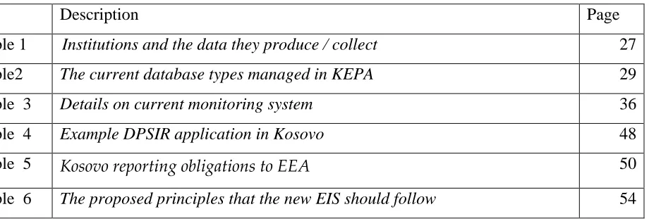
Table 1 Institutions and the data they produce / collect 27
Table2 The current database types managed in KEPA 29
Table 3 Details on current monitoring system 36
Table 4 Example DPSIR application in Kosovo 48
Table 5 Kosovo reporting obligations to EEA 50
Table 6 The proposed principles that the new EIS should follow 54
LIST OF FIGURES
Nr Description Page
[image:5.612.69.544.311.712.2]Figure1 Illustration of moving from data reporting to information systems 8 Figure 2 The main international documents, the EIS development refers to 13
Figure 3 EEA relation to the member countries 18
Figure 4 “Reportnet” one of key EIONET tools 19
Figure 5 Fragment information flow to decentralized but integrated EIS 20
Figure 6 KEPA Structure 24
Figure 7 Chart of Environmental Monitoring Assessment and Reporting Directorate and the EIS position in it
25
Figure 8 Organizations where the KEPA collects the data from 28
Figure 9 Most common information dissemination tools 30
Figure 10 GIS usability 31
Figure 11 Relation of GIS and EIS 33
Figure 12 Kosovo Geoportal 34
Figure 13 Air quality monitoring network in Kosovo 39
Figure 14 Surface water quality monitoring network in Kosovo 40
Figure 15 Description of DPSIR framework 46
5
ABBREVIATIONS
CSI Core Set Indicators
EEA European Environment Agency
EIS Environmental Information System
EIONET European Environment Information and Observation Network
ETC European Topic Center
EU European Union
GEMS Global Environmental Monitoring System
GIS Geographic Information System
INFOTTERA International Environmental Information System
KAS Kosovo Agency of Statistics
KEPA Kosovo Environmental Protection Agency
KHMI Kosovo Hydro-Meteorology Institute
KPHI Kosovo Public Health Institute
MESP Ministry of Environment and Spatial Planning
NFP National Focal Point
NRC National Reference Center
OECD Organization for Economic Cooperation and Development
PSI Public Sector Information
SEIS Shared Environmental Information System
UNECE United Nations Economic Commission for Europe UNEP United Nations Environmental Program
UNDP United Nations Development Program
6
ACKNOWLEDGMENTS
I wish to express my gratitude to all those who supported and helped me with the preparation of this report. In particular, because completion of this capstone project proposal was delayed for a long time due to my personal reasons, I express my appreciation to both Professor Brian Bowen and Professor David Wetzel for their patience, continuous guidance and valuable advices throughout this capstone.
I am also grateful to Dr. Ferat Shala, Deputy Minister of the Ministry of Environment and Spatial Planning; Dr. Ilir Morina, Director General of Kosovo Environmental Protection Agency; and Mr. Afrim Berisha, Head of Environmental Reporting Division for providing their valuable experience and knowledge, also for enabling me to have unrestricted access to all existing reports, documents, and interviewing the relevant staff.
7
EXECUTIVE SUMMARY
This Capstone project addresses the important problem of functional improvement of the National Environmental System in Kosovo. The main issues addressed are the legal requirements for data collection, data processing, validation, and reporting, as stipulated by the law on environment; and the practical needs for improvement in order to make the system more effective, more reliable, and more usable in order to provide timely and accurate environmental data to the policymakers and to overall public.
In order to better address the problem, consideration is given to both international and national context of EIS requirements. This is very relevant given the fact that nowadays, in particular at EU level, there is a need to establish systems which are compatible to each other, and which enable standardization, comparability and verification of data.
To contribute to solving the issue, a review of current EIS, legal and institutional framework, human and technical capacities is made.
Kosovo Environmental Information System is regulated by the law on environment, which provides general principles for establishment of the system. The law stipulates that more detailed structure of the EIS has to be determined by a sub-law act. This sub-law act should define all the details, concerning the data flow, data format, frequency, responsible institutions, and timeframe for data delivery and publication.
8
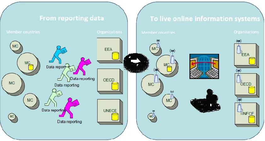
Figure 1. Illustration of moving from data reporting to information systems1
Based on this research, this project provides proposals for the characteristics and features the new EIS should have. As a conclusion, project provides many recommendations which will significantly improve the system. The recommendations are grouped into three categories:
- Development of the sub-law act, procedures, data management, communication tools and networking mechanisms that ensure access to environmentally-relevant data by a wide variety of potential users on local, regional and international levels.
- Strengthen the institutional framework. - Human capacity building.
Methodology and Data Collection
This project is realized by following a combined approach of research in the internet links, materials and reports of organizations, and interviews conducted with EIS relevant officials in a variety of institutions.
Internet research included:
1
9
- Review of official websites of international organizations such as: UNEP, UNECE, OECD, EU commission, EEA, EIONET, etc.
- Review of websites of national institutions such as: MESP, KEPA, GEOPORTAL, National Assembly, etc.
Materials reports reviewed:
- Available national strategic documents
- State of Environment reports published by MESP-KEPA - Reports of HMIK
- Nature Protection Reports
- National Legislation (Laws and sub law acts
Interviews conducted with: - Officials of KEPA
- Officials of Environment Department and Water Department at MESP - Officials of Municipality of Drenas
- Officials of Kosovo Energy Corporate - Officials of KHMI
- Officials of Statistical Office
- Officials of Nature Protection Institute
10
CHAPTER I
EIS INTRODUCTION AND GLOBAL CONTEXT
1.1Introduction of EIS
The term “Environmental Information System” is considered more as an institutional and technical framework than merely a technological solution, essential for improving the flow and use of data and information in environmental management. Environmental Information System as a concept, and as a very important part of environmental management system, emerged as a result of many environmental problems, which are listed in top priority agendas worldwide. In particular the importance of having the timely and accurate environmental information is shown necessary in cases of forest fires, floods, drought, and other fields where the life and wellbeing of humans is directly affected. Nowadays, environmental information serves as the primary data in tackling the environmental challenges such as: air quality and climate changes, ecosystem and natural resource sustainable management, biodiversity protection, water scarcity and water quality, land use, urbanization, infrastructure development, and overall development planning processes.
Availability of the latest information, in many cases, is considered among key factors to success in policy making process. Furthermore, lack of this information may lead to inadequate and unsuccessful policies.
In addition to the use of environmental information in the policy making processes and decision making, the integrated, timely, and easily accessible information is essential for the public in order to understand the quality of the environment they are living in. Also, the factors impacting their environment, the actions needed to prevent the environmental degradation, actions undertaken from the responsible authorities, and for their role on maintaining and protecting the environment.
11
What is environmental information?
According to the EU directive on public access to environmental information and repealing Council Directive 90/313/EEC, environmental information means any information in written, visual, aural, electronic or any other material form on:
a) the state of the elements of the environment, such as air and atmosphere, water, soil, land, landscape and natural sites including wetlands, coastal and marine areas, biological diversity and its components, including genetically modified organisms and the interaction among these elements;
b) factors, such as substances, energy, noise, radiation or waste, including radioactive waste, emissions, discharges and other releases into the environment, affecting or likely to affect the elements of the environment referred to in (a);
c) measures (including administrative measures), such as policies, legislation, plans, programs, environmental agreements, and activities affecting or likely to affect the elements and factors referred to in (a) and (b) as well as measures or activities designed to protect those elements;
d) reports on the implementation of environmental legislation;
e) cost-benefit and other economic analyses and assumptions used within the framework of the measures and activities referred to in (c);
f) the state of human health and safety, including the contamination of the food chain, where relevant, conditions of human life, cultural sites and built structures inasmuch as they are or may be affected by the state of the elements of the environment referred to in (a) or, through those elements, by any of the matters referred to in (b) and (c)
12
According to the practice, the environmental information system (EIS) may be defined as the umbrella term for those systems used for monitoring, data collection storage and access, environmental impact reporting and state of the environment reporting.
In more technical terms, the EIS is considered a technology solution including web application solutions, related databases and communication technologies which enable easy and simple user access. These systems are featured with information classification according to importance of information for specific target user groups, and according to the access level, such as information for general public, or to specific users only.
1.2Brief history of EIS
It is obvious that parallel with the historical developments of environmental movements, the EISs are developed as well. The Stockholm conference on the Human Environment (1972) is considered a starting point in this area. As the outcome of this conference, the United Nations Environmental Program (UNEP) is established. One of the main tasks of UNEP is monitoring the status of the global environment and gathering and disseminating environmental information2. In this respect, the UNEP developed the Global Environmental Monitoring System (GEMS), which later, on 1975 was further developed on GEMS water, and GEMS food3. Further to this the GEMS had created INFOTTERA4 – the International Environmental Information System - probably the first of its kind.
2http://www.unep.org/PDF/UNEPOrganizationProfile.pdf
3http://www.unep.org/gemswater/
13
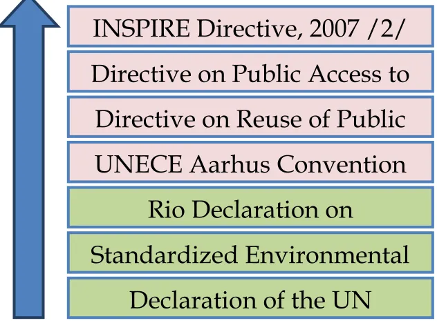
Figure 2. The main international documents, the EIS development refers to.
The next promotion of EIS concept is evidenced in the RIO conference at the Earth Summit of 1992 and “Agenda 21”. The EIS is first mentioned in chapter 12 of Agenda 21, which focuses on desertification:
“Governments at the appropriate level, with the support of the relevant international and regional organizations, should:
Establish and/or strengthen environmental information systems at the national level; Strengthen national, state/provincial and local assessment and ensure
cooperation/networking between existing environmental information and monitoring
systems, such as Earth watch and the Sahara and Sahel Observatory;
Strengthen the capacity of national institutions to analyze environmental data so that
ecological change can be monitored and environmental information obtained on a
continuing basis at the national level.”
Chapter 40 of Agenda 21 is dedicated to the role of information in sustainable development: Article 40.1
INSPIRE Directive, 2007 /2/
EC
Directive on Public Access to
Environmental Information,
2003/98/EC
Directive on Reuse of Public
Sector Information,
2003/98/EC
UNECE Aarhus Convention
on Access to Information, 1998
Rio Declaration on
Environment and
development, June 1992
Standardized Environmental
Reporting Directive, 1991
Declaration of the UN
Stockholm Conference on the
14
“In sustainable development, everyone is a user and provider of information considered in the broad sense. That includes data, information, appropriately packaged experience and
knowledge. The need for information arises at all levels, from that of senior decision makers at
the national and international levels to the grass-roots and individual levels. The following two
program areas need to be implemented to ensure that decisions are based increasingly on sound
information:
1. Bridging the data gap;
2. Improving information availability.”
Later on the United Nations Economic Commission for Europe (UNECE)5 was adopted on 25 June 1998 in the Danish city of Aarhus (Århus) at the Fourth Ministerial Conference as part of the "Environment for Europe" process. It entered into force on 30 October 2001.
The Aarhus Convention establishes a number of rights of the public (individuals and their associations) with regard to the environment. The Parties to the Convention are required to make the necessary provisions so that public authorities (at national, regional or local level) will contribute to these rights to become effective. The Convention promotes three concepts (pillars): access to environmental information; public participation in environmental decision-making; access to justice.
1.3EIS at European Union
The individual EU member states have developed their various EIS in different historical periods, but in this chapter, the EIS development at the EU context is explained only. This is of particular importance because the EU integration process is one of the main policy objectives of Kosovo, and because the Kosovo institutions have already started cooperation and integration into the EU EIS. As a consequence, development of Kosovo EISs will have to be compliant and compatible with the EU ones.
15
1.3.1 EU EIS Legal framework
The first concrete document which addresses directly the EIS at EU level is the Council
Directive 91/692/EEC of 23 December 1991, on standardizing and rationalizing reports on the
implementation of certain Directives relating to the environment. The purpose of this Directive is to rationalize and improve on a sectorial basis the provisions on the transmission of information and the publication of reports concerning certain Community Directives on the protection of the environment6.
Afterward, the Directive on the re-use of public sector information (Directive 2003/98/EC known as the 'PSI Directive') is regarded as an important step towards creating the legal bases for availability of public sector data, including the environmental data. It addresses material held by public sector bodies in the Member States, at national, regional and local levels, such as ministries, state agencies, municipalities, as well as organizations funded for the most part by or under the control of public authorities (e.g. meteorological institutes). It was adopted on 17 November 2003 and entered into force on 31 December 20037.
In 2003 the European Parliament and the European Council adopted the Directive 2003/4/EC on public access to environmental information
The purpose of this Directive is to ensure that environmental information is systematically available and distributed to the public8. According to this directive 'Information relating to the environment' means any available information in written, visual, aural or data-base form on the state of water, air, soil, fauna, flora, land and natural sites, and on activities or measures adversely affecting or likely so to affect these, and on activities or measures designed to protect these (including administrative measures and environmental management programs).
International treaties, conventions and agreements and Community, national, regional
and local legislation concerning the environment;
Environment policies, programs and plans;
6http://eur-lex.europa.eu/LexUriServ/site/en/consleg/1991/L/01991L0692-20031120-en.pdf
7http://ec.europa.eu/digital-agenda/en/legal-rules
16 Reports on the state of the environment (to be published at least every four years);
Data on activities affecting the environment;
Environmental authorizations and agreements;
Environmental impact studies and risk assessments
In Europe another major recent development has been the entering in force of the INSPIRE Directive in May 2007, establishing an infrastructure for spatial information in Europe to support Community environmental policies, and policies or activities which may have an impact on the environment.
1.3.2 Main EU Institutions Relevant to EIS
EU Commission Directorate-General Environment (DG)
The main role of the European Commission's Environment Directorate-General (DG) is to initiate and define new environmental legislation and to ensure that agreed measures are put into practice in the EU Member States. Commonly referred to as DG Environment, the objective of the Directorate-General is to protect, preserve and improve the environment for present and future generations. To achieve this, it proposes policies that ensure a high level of environmental protection in the European Union and that preserve the quality of life of EU citizens.
EU Commission -Directorate-General for Climate Action ("DG CLIMA")
17 European Environment Agency
The European Environment Agency (EEA) is an agency of the European Union. Its task is to provide sound, independent information on the environment. The EEA is a major information source for those involved in developing, adopting, implementing and evaluating environmental policy, and also the general public. Currently, the EEA has 33 member countries. Balkan countries, including Kosovo have the status of Cooperating Countries to EEA and are fully integrated into the EEA work.
The regulation9 establishing the EEA was adopted by the European Union in 1990. It came into force in late 1993 immediately after the decision was taken to locate the EEA in Copenhagen. Work started in 1994. The regulation also established the European environment information and observation network (EIONET).
EEA's mandate is:
To help the Community and member countries make informed decisions about improving the environment, integrating environmental considerations into economic policies and moving towards sustainability
To coordinate the European environment information and observation network
The core objective of the EEA is to produce European, pan-European and regional integrated environmental data and indicator sets, assessments and thematic analyses in order to provide a sound decision basis for environmental policies in the EU and Member countries and for cooperation with candidate and potential candidate countries and those covered by the European Neighborhood Policy10.
The EEA covers all environmental topics at EU level. Its main topics are: Air Pollution, Biodiversity, Climate Change, Land Use and Water. It collects large amounts of information from different sources including satellites and sensors.
The EEA itself represents a very large and complex Environmental Information System.
9Council Regulation (EEC) No 1210/90 of 7 May 1990, which is amended substantially several times.
http://eur-lex.europa.eu/LexUriServ/LexUriServ.do?uri=CELEX:32009R0401:EN:NOT
18
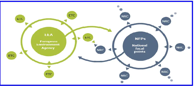
Figure 3. EEA relation to the member countries11
European Environment Information and Observation Network -EIONET
EIONET is a partnership network of the European Environment Agency (EEA) and its member and cooperating countries. It consists of the EEA itself, six European Topic Centers (ETCs) and a network of around 1000 experts from 39 countries in over 350 national environment agencies and other bodies dealing with environmental information. These are the National Focal Points (NFPs) and the National Reference Centers (NRCs).
The EIONET partnership is crucial to the EEA in supporting the collection and organization of data and the development and dissemination of information. The organizations and individuals in the network are supported by an extensive information technology infrastructure (referred to as e-Eionet).
Through EIONET, the EEA coordinates the delivery of timely, nationally validated, high-quality environmental data from individual countries. This forms the basis of integrated environmental assessments and knowledge that is disseminated and made accessible through the EEA website.
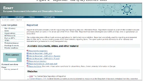
This network is consisted of several electronic tools for data collection and dissemination.
19
Figure 4. “Reportnet” one of key EIONET tools12
1.4SEIS
The Shared Environmental Information System (SEIS) is a collaborative initiative (2008) of the European Commission and the (EEA) to establish together with the Member States an integrated and shared EU-wide environmental information system. It is based on technologies such as the internet and satellite systems and thus making environmental information more readily available and easier to understand to policy makers and the public.
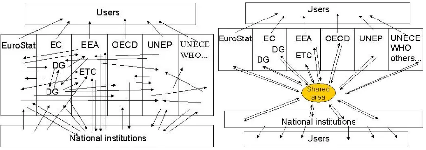
According to the SEIS concept, environmentally-related data and information are stored in electronic databases throughout the European Union. These databases are interconnected and are compatible with each other. The SEIS is a decentralized but integrated web-enabled information system based on a network of public information providers sharing environmental data and information.
20
Figure 5. Fragment information flow to decentralized but integrated EIS13
According to the SEIS principles the Information should be
• Managed as close as possible to its source;
• Collected once, and shared with others for many purposes;
• Readily available and easy accessible;
• Accessible to enable users to make comparisons at the appropriate geographical scale;
• Fully available to the general public at national level in the relevant national language(s);
• Supported through common, free open software standards;
21
CHAPTER II
EIS IN KOSOVO
2.1 Historical Development of Environmental Information in Kosovo
First steps for nature and environment protection in Kosovo are recorded since the end of the 1960’s. The Unit for Nature Protection within Kosovo Authority for Protection of Culture Monuments was established in 1968.In 1974 the Authority (office) for Nature Protection is established by the law for establishing the Kosovo Authority for Nature Protection. In 1988, the Kosovo Assembly adopted the law for nature values protection and development, where the article 78 paragraph 2 of this law describes the activities of this authority. One year later, the Kosovo Assembly adopts the law for Kosovo Authority for Nature and Environment Protection.
In the year 2000, the ex-authority for Nature and Environment Protection is registered as the “Kosovo Institute for Nature and Environment Protection” with its headquarters in Prishtina. In May 2000, the Department for Environment Protection was established, and within it following institutions are subordinated: Kosovo Institute fort Nature and Environment Protection, Kosovo Hydro-meteorological Institute and the authority of National Park “Mali Sharr”14.After the National Election (2001) and establishment of governmental institutions of Kosovo, the Ministry of Environment and Spatial Planning was established, which then took the role of umbrella institution for other government environmental institutions.
In 2003, by the Law on environment protection, the Kosovo Environmental Protection Agency was established, within the MESP. Although, this agency only became functional in 2006.
The Nature Institute has historically produced reports resulting from research projects, and reports from monitoring visits from nature protected areas. A more comprehensive report, which considered the main environmental pollution concerns in Kosovo was the report from the UNPROKOS program, an environment monitoring project implemented in partnership of UNDP, WHO and national institutions in 1992. This report provided the information on the state
14 The historical data of nature protection institute are taken from the State of Nature Report 2006 - 2007
22
of environment, based on measurements from the project activities. The first comprehensive report on the state of environment was published by KEPA in 2007. This report covered all environmental sectors, including the driving forces, pressures, and measures undertaken from the responsible authorities on environmental protection.
2.2 National Legal framework related to EIS
Law No. 03/L-025 on environmental protection: defines the environmental information as “any information in written, visual, oral, electronic or any other material on state of the elements of environment, measures, reports, cost-benefit analyses and the state of human health”.
Article52 of this law provides that the MESP establishes the EIS and describes the tasks of the SEI which include gathering, classification, maintenance, presentation and distribution of environmental data. This article includes that “the SEI shall provide access for other information systems and harmonization of all relevant information and data at national and international level”.
Article 60 of this law, describes the KEPA tasks, and specifies that the KEPA
- provide proper information for administration, Government and Kosovo Assembly for the implementation of environmental protection policies;
- develop and coordinate unique system of information on environmental protection regarding to system for conduction of environmental state in Kosovo as well as collecting the records for environment.
Other Laws that directly address the environmental information are:
- Law No. 03/L-160 on air protection from pollution - Law No.2004/24 Kosovo water law
23
There are other laws and sub legal acts (Administrative Instructions) which address the public access to the environmental information, public involvement in the decision making process etc.
It has to be mentioned that the Kosovo Environmental Legislation is harmonized with the EU legislation, which means even though Kosovo is not a member state to EU, UN, and many other international agreements, the environmental information provisions of international documents such as Aarhus convention and related EU directives are transposed into the national legislation.
2.3 KEPA the responsible institution for EIS
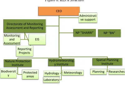
KEPA is a government organization subordinated by the MESP. It consists of Directorates and Institutes as follows:
- Directorate on Environmental Monitoring Assessment and Reporting - Directorate of “Sharri” National Park
- Directorate of “Bjeshket e Nemuna” National Park - Spatial Planning Institute
24
Figure 6. KEPA Structure
The two Directorates of National Parks are responsible for management, protection and development of the parks, in accordance with the provisions of the Law on Nature Protection.
The Institute of Nature Protection is in charge for biodiversity and nature monitoring. Also, for
coordinating researches and other activities related to the nature protected areas.
The Spatial Planning Institute is responsible for development of spatial plans for specific areas /
territories as requested by the Kosovo Government or the MESP. Such cases include, Kosovo Spatial Plan, Spatial Plans for National Parks, Spatial Plans for other nature protected areas and others.
The Hydro-Meteorological Institute manages the air quality monitoring network, hydrometric
monitoring network and water quality monitoring stations. This Institute also manages the laboratory and conducts analysis of air, water and soil samples. In addition, this institute measures the meteorological elements including wind speed and direction, temperature, precipitation, etc.
CEO
Nature Protection Institute
Biodiversit
y Protected areas
Hydrometeorolog y Institute Hydrology Meteorology Laboratory Spatial Planning Institute Planning Researches
Directorate of Monitoring Assessment and Reporting
25
The Directorate of Environmental Monitoring, Assessment and Reportingis the key unit within
KEPA related to the EIS. This directorate includes specific sub-unit air, water, soil, noise, project development, communication and cooperation and the most important one -for the purposes of this capstone- the Division of Environmental Information System.
[image:26.612.136.377.364.596.2]The experts from specific sectors (units) collect, process, validate and report the data collected from environmental monitoring units and other relevant institutions. The EIS unit maintains the databases, develops forms of data collection, contacts the institutions and coordinates all data flow at the KEPA. An important part of the EIS unit is the GIS sector, which is used as an integrated part of environmental data management at KEPA.
Figure 7. Chart of Environmental Monitoring Assessment and Reporting Directorate, and the EIS position in it.
Tasks of KEPA that relates to the EIS include15:
- To follow and calculate trends in environmental sectors and pressures from specific sectors (industry, energy, tourism, transport, agriculture, etc.).
26
- To prepare sectoral and overall environmental status reports.
- To coordinate data exchange with EU Institutions: European Environment Information and Observation Network (EIONET) and Shared Environmental Information System (SEIS).
- To organize prompt and easy access to the environmental data for a wide range of stakeholders (general public, experts, and authorized institutions).
2.4 Current Activities - Data Flow and Data Management
2.4.1. Institutions where the data is collected from
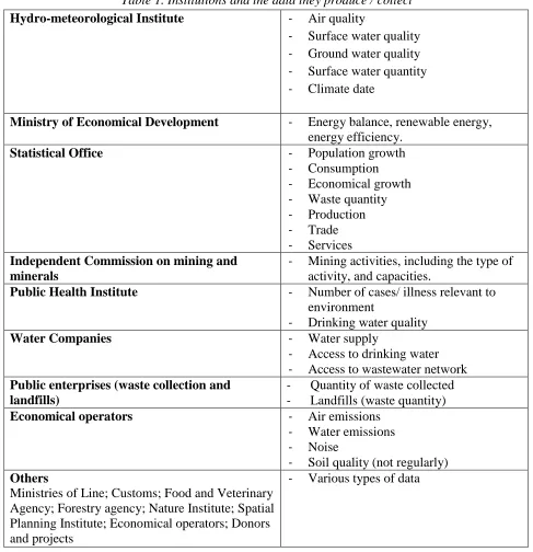
As environment is getting on the top of the policy priority agendas, the environmental requirements are considered a horizontal policy and a horizontal legislation that is included in almost all other development sectors. In order to address the environmental issues within specific sectors/policies/institutions (i.e. transport, energy, agriculture), environmental information is needed. In this regard, the Kosovo Institutions have established their own specific environmental units, and perhaps their own EIS. All of such organizations/institutions have both important roles: all of them produce environmental information and all of them need other environmental information.
27
Table 1. Institutions and the data they produce / collect
Hydro-meteorological Institute - Air quality
- Surface water quality
- Ground water quality
- Surface water quantity
- Climate date
Ministry of Economical Development - Energy balance, renewable energy,
energy efficiency.
Statistical Office - Population growth
- Consumption
- Economical growth
- Waste quantity
- Production
- Trade
- Services Independent Commission on mining and
minerals
- Mining activities, including the type of activity, and capacities.
Public Health Institute - Number of cases/ illness relevant to
environment
- Drinking water quality
Water Companies - Water supply
- Access to drinking water
- Access to wastewater network Public enterprises (waste collection and
landfills)
- Quantity of waste collected
- Landfills (waste quantity)
Economical operators - Air emissions
- Water emissions
- Noise
- Soil quality (not regularly) Others
Ministries of Line; Customs; Food and Veterinary Agency; Forestry agency; Nature Institute; Spatial Planning Institute; Economical operators; Donors and projects
- Various types of data
28
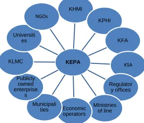
[image:29.612.149.444.186.438.2]This unit collects and coordinates the data collection within the MESP departments and other and from other institutions and organizations as well.
Figure 8. Organizations where the KEPA collects the data from16
In most of the cases aggregated data collection, which in order to be available for public or other aimed targets, need to be further processed.
Further, a process of data validation is conducted via sector experts of KEPA. There is no specific tool developed for data validation, quality insurance and quality control.
16 Figure prepared by KEPA
KEPA KHMI
KPHI
KFA
KSA
Regulator y offices
MInistries of line Economic
operators Municipali
ties Publicly
owned enterprise
s KLMC
Universiti es
29
2.4.2.KEPA Databases
[image:30.612.65.550.222.434.2]The collected data is stored in different formats but mostly in common databases and data sheets. Given the reporting obligation to the EEA, specific sectors at KEPA have started to develop database structures that are compatible with the EEA/EIONET formats. This is necessary because the EEA collects the data from all EEA member and cooperating countries.
Table 2. The current database types managed in KEPA.
Access: - Protected areas
- Environmental hotspots
- Inventory of pollution sources
- Landfills
Excel - Surface water monitoring data
- Lake water quality
- Data from Economical operators
SQL - Water pollutants cadastre
- Surface water quality
GIS - Various geographical data from all sectors
2.4.3. Information dissemination
Almost all the environmental information of KEPA is made available to the public by various means. The most common way of making the information available for the public is through environmental report. Based on the Law on Environment, the KEPA produces yearly state of environment reports. These reports include data from all sectors such as: air, water, soil, health, as well as information on measures undertaken from responsible institutions, legislation developments, environmental investments, and projects.
30
KEPA also provides data based on specific requests from government, ministries, municipalities NGOs and other interested, by means of CD, emails, and in some cases, paper formats.
[image:31.612.190.416.267.518.2]The KEPA website is an open window with no restrictions or availability for specific users. Recently KEPA is using the social networks, such as Facebook to publish information on specific developments where the links and sources of particular information are also provided.
Figure 9. Most common information dissemination tools
2.5. EIS and GIS
GIS is a powerful software technology that allows a virtually unlimited amount of
information to be linked to a geographic location17. Coupled with a digital map, GIS
allows a user to see locations, events, features, and environmental changes with
unprecedented clarity. Showing layer upon layer of information such as environmental
31
trends, soil stability, pesticide use, migration corridors, hazardous waste generators,
dust source points, lake remediation efforts, at-risk water wells and other similar areas.
GIS technology offers a wide variety of analytical tools to meet the needs of many
[image:32.612.175.443.209.494.2]people, helping them make better decisions about the environment.
Figure 10. GIS usability18
Geographic Information System (GIS) technology is used to support and deliver
information to environmental managers and the public. GIS allows the combination and
analysis of multiple layers of location-based data including environmental
measurements. The environmental application areas of GIS are varied in terms of
potential users, environmental spheres, and the specific environmental issue being
investigated.
32
GIS enable organizations to:
- Ensure accurate reporting with improved data collection
- Improve decision making
- Increase productivity with streamlined work processes
- Provide better data analysis and presentation options
- Model dynamic environmental phenomena
- Create predictive scenarios for environmental impact studies
- Automate regulatory compliance processes
- Disseminate maps and share map data across the Internet
33
Figure 11.Relation of GIS and EIS19
Importance of GIS is recognized and emphasized even at Agenda 21. According to Article 40, “Relevant international organizations should develop practical recommendations for coordinated, harmonized collection and assessment of data at the national and international levels. National and International data and information centers should set up continuous and accurate data-collection systems and make use of geographic information systems, expert systems, models and a variety of other techniques for the assessment and analysis of data. These steps will be particularly relevant, as large quantities of data from satellite sources will need to be processed in the future. Developed countries and international organizations, as well as the private sector, should cooperate, in particular with developing countries, upon request, to facilitate their acquiring these technologies and this know-how20.”
19 Figure taken from EIS unit at KEPA
34
GIS is also widely used in Kosovo. Since 2002, within the MESP, a GIS unit was established which is later transferred to KEPA. GIS units also operate at the Water Department and Spatial Planning Institute of the MESP. By then, many organizations and institutions have established GIS units, such as: some larger municipalities, independent agencies, public companies, etc. Also, GIS is one of the courses taught in the Department of Geography of the University of Pristina.
[image:35.612.77.521.298.582.2]Within the EIS at KEPA, the GIS is used to create and manage numerous environmental data for air, waters, protected areas, economic operators, infrastructure projects, etc.. The GIS experts in Kosovo use the MapInfo and ArcGIS software mainly.
Figure 12. Kosovo Geoportal21
A relevant example of the use of GIS in Kosovo is the Kosovo Geoportal. Kosovo Cadastral Agency has developed Geoportal which aims to provide complete geographical information, offering users a wide range of geographical and textual tools. Geoportal is a web portal that presents geographic information from different sources in a unified form. Through Geoportal,
35
users can search, read and download geographic data which are located in the database of Kosovo Cadastral Agency. Also, data from various providers can be provided through the Geoportal.
36
CHAPTER III
ENVIRONMENTAL MONITORING THE MAIN EIS DATA SUPPLIER
3.1. Current monitoring system
Environmental monitoring activities play a major role in the Environmental Information System in Kosovo, but worldwide as well. This process is understood as a systematic observance of main environmental components quality such as: air, water, soil, biodiversity, which includes sampling, and analysis tasks. However, according to the EIS practice, as defined by the EU environment information directive, and by the Kosovo Legislation as well, in addition to the information on the state of the environment (environment quality), other information is considered as environmental information as well. Such information include, economical-social developments, actions undertaken to prevent the environmental degradation, actions for improvements etc, which will be more explained in the next chapter.
[image:37.612.67.546.488.678.2]In this chapter, the air and water monitoring in Kosovo is elaborated. Other sectors are excluded from the elaboration, not because they are not important, but because the air and water sectors involve the majority of monitoring and reporting activities, which consequently require the majority of efforts for establishing and maintaining the environmental information system. An overall overview of the Environment Monitoring System is provided in the table below.
Table 3.Details on current monitoring system22
Monitoring topic Monitoring network Monitoring frequency Parameters monitored
Air quality monitoring
12 automatic and one mobile air quality monitoring stations
Permanent monitoring (24/7)
SO2, CO, NO2, O3, PM10, PM 2.5.
Surface water quality monitoring
54 sampling sites in 4 river basins
At 18 referent stations twice a year; in 36 other stations each month.
10 physical parameters, 39 chemical parameters and 8 heavy metals.
Ground water quality monitoring
No established network. Monitoring is made by RWC and projects
Based on projects and requests.
Physical chemical and heavy metals parameters.
37 Water emission
monitoring
Monitoring based on requests by inspectorate only
By requests only Depending on the request
River water quantity monitoring / hydrometric network
22 hydrometric station and two stations for flood risk early warning.
Hydrometric stations 24/7
Inflow 1-12 times a year, Early warning stations 24/7
Level (h), inflow (Q) and river profile.
Greenhouse gases monitoring
It is calculation / assessment based monitoring. Based on IPCC guidelines
Annual GhG reporting GhG (CO2,CH4, N2O, HFCs, PFCs, SF6.),
Soil monitoring No network established.
Mostly project based
Based on project, and request
Heavy metals and organic parameters
Waste monitoring Monitoring of waste
landfill
Monitoring visits twice a year
Landfill management Waste compacting Wastewater treatment Self monitoring by
economical operators
Monitoring by KEC, NewCo Feronikeli and Sharrcem
Daily, monthly and periodical, depending on parameters
Air, water, soil, emissions
Monitoring of nature protected areas
105 nature protected areas
At least once a year 2 National Parks; 99 Nature monuments; 2 Protected landscapes; 1 regional park; 1 important bird area.
Biodiversity monitoring
Monitoring of endangered species
Monitoring by video cameras, periodically
Lynx; wild goat, brown bear, etc.
Monitoring of climate conditions
7meteorological stations 5 stations 3-6 times a day
2 stations, permanent / online monitoring
Temperature, pressure, humidity, winds peed, wind direction etc.
3.2. Air Quality Monitoring
38
The Administrative InstructionNo.15/2010 sets the criteria for defining the air quality monitoring points, number and frequency of measurements, classification of pollutants which are monitored, the methodology of work, form and timing of data reporting. Rules and standards of the discharges on air by the stationary sources of pollution are set by the Administrative Instruction No.06/2007. The air quality limit values are set by the AINo.02/2011; whereas, the allowed norms of discharges on the air from mobile sources are set by the AI No. 03/2011.
As regard to the air monitoring, both air emissions and air quality has to be monitored. Air emissions and air quality data are among the most important data related to the environmental assessment and therefore is one of main components of the Environmental Information System.
The Sector of air quality monitoring in Kosovo consists of following establishments:
Automatic air quality monitoring stations
Laboratory of air chemical analysis for determining organic and inorganic pollutants in the air;
Laboratory for calibration of air analyzers.
The number and locations of air quality monitoring stations are determined on the basis of a preliminary study conducted in order to determine the monitoring points based on the criteria of Directive 2008/50/EC, and the AI on criteria for determination of monitoring points, the number and frequency of measurements, methodology, form and timing of data reporting, Nr.15/2010
Based on the above mentioned study, it is decided that the Kosovo air quality monitoring network is to have9 automatic monitoring stations and one mobile monitoring station. The zoning was made as well. Kosovo territory is divided in two zones: one agglomeration zone (Pristina), and the rest of the country forms one zone.
39
Figure 13. Air quality monitoring network in Kosovo23
In addition to the 9 monitoring stations spread over the Kosovo territory, there are three other stations located at Obiliq area, which were donated by USAID, and which were aimed to monitor the air quality in the area affected directly by KEK operations. All the three stations measures the same parameters as the other stations.
40
3.3. Water Quality Monitoring
[image:41.612.112.492.252.668.2]River water quality in the territory of the Republic of Kosovo is monitored by the Hydro-meteorological Institute of Kosovo. The river water quality is determined on the basis of physical, chemical and heavy metal analysis. This monitoring network is consisted of 54 monitoring sites. 10 physical parameters are measured 11 times a year, 39 chemical parameters are measured 11 times a year, and 8 parameters of heavy metals are measured twice a year24.
Figure 14.Surface water quality monitoring network in Kosovo25
24 Data and map received from the KHMI
41
42
CHAPTER IV
ASSESSMENT AND REPORTING
4.1. Indicator Based information
According to the EEA, an indicator is a measure, generally quantitative, that can be used to illustrate and communicate complex phenomena simply including trends and progress over time. An indicator provides a clue to a matter of larger significance or makes perceptible a trend or phenomenon that is not immediately detectable. An indicator is a sign or symptom that makes something known with a reasonable degree of certainty. An indicator reveals, gives evidence, and its significance extends beyond what is actually measured to a larger phenomenon of interest26
OECD defines indicator as: “A parameter or a value derived from parameters, which points to, provides information about, or describes the state of a phenomenon, environment, area, with a significance extending beyond that directly associated with a parameter value.”
Indicators, simply defined as the products of data processing, whereas data is measured, calculated or based on expert judgment, are well recognized as the efficient form for monitoring the state of the environment and achieving goals of sectoral policies and strategies.
Environmental indicators are primarily used to assess and report the state of the environment and its component. Some of the roles of indicators include:
- To supply information on environmental problems, in order to enable policy-makers to value their seriousness;
- To support policy development and priority setting, by identifying key factors that cause pressure on environment; To monitor the effects of policy responses;
- A powerful tool to raise public awareness on environmental issues.
26EEA core set of indicators — Guide (EEA Technical report No 1/2005 — ISSN 1725-2237); Luxembourg: Office for
43
In order to be effectively usable an indicator should be27: - Relevant to an issue;
- Expressed as ‘below’ or ‘above’ a target; - Comparable internationally;
- Based on available or cost-efficient data; - Easy to communicate and understand.
Environmental indicators should provide information about phenomena that are regarded typical for and/or critical to environmental quality.
The “TRUE” concept provides for some of necessary features an indicator should have: - T: Timely, targeted and sensitive to targets/thresholds
- R: Reliable, relevant, resonant and responsive
- U: Useful for the public, policy-makers and program administrators - E: Easily accessible periodically from reputable sources
Although, an indicator does not necessarily disclose all aspects behind a change (more indicators may have to be considered). Indicators evolve over time, and are seldom incomplete
EEA CSI
The EEA management board approved the core set of indicators in March 2004. The set has been established for three main purposes: to provide a manageable and stable basis for indicator-based reporting by the EEA; to prioritize improvements in the quality and geographical coverage of data flows, especially EIONET priority data flows; and, to streamline EEA/EIONET’s contributions to other European and global indicator initiatives, for example, EU structural indicators, EU sustainable development indicators and OECD environment indicators.
27Zoï Environment Network 2012; ISBN: 978-2-940490-01-1;
44
The EEA classifies its indicators according to a typology: A = descriptive indicator, B = performance indicator, C = eco-efficiency indicator, D = policy effectiveness indicator, E = total welfare indicator.
The core set covers six environmental themes (air pollution and ozone depletion, climate change, waste, water, biodiversity and terrestrial environment) and four sectors (agriculture, energy, transport and fisheries). The list of EEA CSI is included in the appendix of this report.
4.2. DPSIR Framework
A prerequisite for the assessment and reporting on the state of the environment and its evolution as affected by human activity is the identification of adequate sets of indicators to be surveyed and the definition of a functional scheme to describe cause-effect linking the state of the various – ecological, economic, social, technological–indicators.
Different approaches and frameworks were used for purposes of environmental assessment and reporting. Currently the most common framework is the DPSIR introduced by the EEA. The DPSIR stands for: D – driving forces; P-pressures; S-state; I-impact; and R-responses.
Driving Forces
A ‘driving force’ is a need. Examples of primary driving forces for an individual are the need for shelter, food and water. Examples of secondary driving forces are the need for mobility, entertainment and culture. For an industrial sector, a driving force could be the need to be profit and to produce at low costs, while for a nation a driving force could be the need to keep unemployment levels low. In a macroeconomic context, production or consumption processes are structured according to economic sectors (e.g. agriculture, energy, industry, transport, households). But in a more concrete context as main driving forces are considered:
- Population (number, age structure, education levels, political stability)
- Transport (persons, goods; road, water, air, off-road)
- Energy use (energy factors per type of activity, fuel types, technology)
45
- Industry (types of plants, age structure, resource types)
- Refineries/Mining (types of plant/mining, age structure)
- Agriculture (number of animals, types of crops, stables, fertilizers)
- Landfills (type, age)
- Sewage systems (types)
- Non-industrial sectors
- Land use
Pressures
Driving forces lead to human activities such as transportation or food production, i.e. result in meeting a need. These human activities exert 'pressures' on the environment, as a result of production or consumption processes, which can be divided into three main types: 1)Excessive use of environmental resources, 2) Changes in land use, and 3) emissions of chemicals, waste, radiation, noise) to air, water and soil. Typically, as pressures are considered:
- Emissions (per driving force for numerous compounds)
- Emissions to air, water and soil
- Production of waste
- Production of noise
- Radiation
- Vibration
- Hazards (risks)
States
As a result of pressures, the ‘state’ of the environment is affected; that is, the quality of the various environmental compartments (air, water, soil, etc.) in relation to the functions that these compartments fulfill. The ‘state of the environment’ is thus the combination of the physical, chemical and biological conditions. With the “states” is meant the state of:
- Air quality (national, regional, local, urban, etc.)
46
- Soil quality (national, local, natural areas, agricultural areas)
- Ecosystems (biodiversity, vegetation, soil organisms, water organisms) - Humans (health)
- Soil
Impacts
The changes in the physical, chemical or biological state of the environment determine the quality of ecosystems and the welfare of human beings. In other words, changes in the state may have environmental or economic ‘impacts’ on the functioning of ecosystems, their life supporting abilities, and ultimately on human health and on the economic and social performance of society.
Responses
A ‘response’ by society or policy makers is the result of an undesired impact and can affect any part of the chain between driving forces and impacts. An example of a response related to driving forces is a policy to change mode of transportation, (for example: from private (cars) to public (trains), while an example of a response related to pressures is a regulation concerning permissible SO2emissions.
47
The DPSIR framework has been used for a variety of applications including:
- Deriving indicators of sustainability which can be used in monitoring programs, or mapped to quantify and track current and future levels of key metrics.
- Summarizing and categorizing information from a variety of sources.
[image:48.612.157.462.229.553.2]- Providing a framework for developing models or decision support tools which can be used to evaluate and compare decision outcomes.
Figure 15. Description of DPSIR framework28
48
Table 4. Example DPSIR application in Kosovo29
Driver Pressure State Impact Response
Increased energy demand leads to increased electric energy generation
Increased rate of emission from KEK chimneys
The concentration of PM 2.5 and 10 exceeds the Limit values for certain units Affected ecosystem, affected population health New energy policies Energy efficiency New taxes etc
Transport of goods and passengers Increased air emissions Increased noise Increased concentration of air pollutants Health damages Risks/hazards Land use Promoting the public transport New road scheme New tax policy
4.3. Reporting obligations
Environmental reporting has been gaining momentum over the past decade as an
important tool for monitoring and evaluating environmental resources and their
changes over time. Examples are the State-of-the-Environment reports published every
year by national and international environmental agencies.
By the national legislation, organizations that have significant impact to the
environment and that are subject to the environmental permission are obliged to submit
annual/ and or periodical reports to the MESP/KEPA. Furthermore, the Kosovo national
legislation requires the KEPA to submit annual reports on the state of the Environment
to the Government and to the National Assembly. Also, the air law and nature law
requires annual reporting on the air quality and state of nature. On its way to European
Union Integration, Kosovo Institutions have taken the responsibility to transpose the
EU Directives that include the EU environmental reporting obligations. Almost each of
EU environmental directives is followed with specific reporting obligations that Kosovo
has to fulfill in the near future. Kosovo is not yet a party of International Environmental
Conventions (and other types of international agreements), but nevertheless, it is
49
expected in the near future to be a party of those conventions that will involve
environmental reporting obligations.
Currently the KEPA produces the following reports in respond to the national legal
requirements:
- State of environment report –annually
- State of the air report – Not specified
- State of nature report - each two years
- State of Water – Not specified
- Waste report – each years
- GhG report – Not specified
- Other reports – As demanded by MESP, Government, or in other specific
situations
In addition, by the request of the MESP, or in situations when any specific need emerges, KEPA produces specific reports, such as: the Hot-Spot report, Water pollutants cadastre report, etc.
50
Table 5. Kosovo reporting obligations to EEA30
Report Obligation
D) Information on the assessment methods (Articles 8 and 9)
COMMISSION IMPLEMENTING DECISION of 12 December 2011 laying down rules for Directives 2004/107/EC and 2008/50/EC of the European Parliament and of the Council as regards the reciprocal exchange of information and reporting on ambient air quality (notified under document C(2011) 9068)(2011/850/EU)
(E1a) Information on primary validated assessment data -measurements (Article 10)
COMMISSION IMPLEMENTING DECISION of 12 December 2011 laying down rules for Directives 2004/107/EC and 2008/50/EC of the European Parliament and of the Council as regards the reciprocal exchange of information and reporting on ambient air quality (notified under document C(2011) 9068)(2011/850/EU)
(E2a) Information on primary uptodate assessment data
-measurements (Article 10)
COMMISSION IMPLEMENTING DECISION of 12 December 2011 laying down rules for Directives 2004/107/EC and 2008/50/EC of the European Parliament and of the Council as regards the reciprocal exchange of information and reporting on ambient air quality (notified under document C(2011) 9068)(2011/850/EU)
Country fact sheets on waste policies
EEA Annual Management Plan
EoI Data on air quality measurements at monitoring stations
Council Decision 97/101/EC of 27 January 1997 establishing a reciprocal exchange of information and data from networks and individual stations measuring ambient air pollution within the Member States
Groundwater quality (EWN-3) EEA Annual Management Plan
Inland waters Decision No 1578/2007/EC of the European Parliament and of the Council of 11 December 2007 on the Community Statistical Programme 2008 to 2012
Lake quality (EWN-2) EEA Annual Management Plan
Monthly ozone exceedances Directive 2002/3/EC of the European Parliament and of the Council of 12 February 2002 relating to ozone in ambient air (OJ L67, 09.03.2002, p.14-30)
Nationally designated areas EEA Annual Management Plan
River quality (EWN-1) EEA Annual Management Plan
State & Quantity of Water Resources (EWN-4)
EEA Annual Management Plan
Summer ozone exceedances Directive 2002/3/EC of the European Parliament and of the Council of 12 February 2002 relating to ozone in ambient air (OJ L67, 09.03.2002, p.14-30)
Water emission quality (WISE-1) EEA Annual Management Plan
51
CHAPTER V
DEVELOPMENT OF NATIONAL EIS
5.1. Proposed Legal and Institutional Upgrading
A key step in development of the new and effective EIS will be to modernize the legal
provisions relating to the way in which information required in various pieces of environmental
legislation is made available. This could be fulfilled by developing and adopting the legal act on EIS.
The law Nr. 03/L-025, article 52, paragraph 4, stipulates that the Environmental Information System has to be developed by a specific sub-law act (administrative instruction). This legal act would regulate the data management and data flow between different institutions. More concretely the legal act would regulate:
- Type of data and respective institution to be delivered to KEPA as a central Environmental Data institution;
- The manner, frequency, format and timing of data delivery;
- Define the rules of cooperation on data exchange and data flow;
- Define the responsible people (officials) as a contact points for cooperation with KEPA
- Define the platforms, tools, and other means to be used;
- Defines roles, responsibilities, and competencies for access to databases and or components of EIS.
This legal act will contribute to substantially improve the EIS, increase the effectiveness and usability, however, still remain in areas which are not covered by legislation and which has to be regulated. The case is for sectoral aspects of EIS.
52
- Water information system, which also has to integrate other sub-systems that include data from municipalities, Regional Water Companies, Regulatory Offices, etc,
- Waste information system, which has to be interconnected with other sub-systems such data from waste collection companies, land filling companies, recycling companies, etc.
- Greenhouse gases information system, for which a variety of data such as from energy, agriculture, transportation, industry, mining, customs, etc.
The new legislation should clearly define the way all those systems have to be interlinked, access of official persons in charge of maintenance and data entry, access and use by official persons, and public access.
Concerning institutional upgrading, the EIS division at KEPA should have additional operational units and staff such as:
- Data management unit – that would include data collection, data processing, and data storage.
- Software (database developing) unit – this would include maintenance of existing databases, and developing new sets of data bases which would respond to the permanently raising needs. This would include information technology expertise as well.
- Web developer and web maintenance unit.
- GIS unit