THESES. SIS/LIBRARY R.G. MENZIES BUILDING N0.2 Australian National University Canberra ACT 0200 Australia
USE OF THESES
This copy is supplied for purposes of private study and research only. Passages from the thesis may not be copied or closely paraphrased without the
written consent of the author.
Telephone: -+61 2 6125 4631 Facsimile: -+61 2 6125 4063
/l, c
v;
6cz,;
k
r I 0r-
C'r · \
·
HUMAN OCCUPATION ON ROTE AND SAWU ISLANDS,
NUSA TENGGARA TIMUR
Ora. MAHIRTA, MA
A thesis submitted in total fulfilment
for the degree Of Doctor of Philosophy
Except where otherwise acknowledged This thesis is my own work
ACKNOWLEDGEMENTS
First of all I would like to express my great thanks to my supervisors Prof. Peter Bellwood and Prof. Matthew Spriggs of the School of Archaeology and Anthropology, Australian National University, for supervising my thesis writing. Apart from their comments and suggestion on my thesis drafts, they gave continuing encouragement and support thoughout my thesis writing. Great thanks are also due to my advisors Dr Peter Hiscock and Dr Mary-Jane Mountain for general advice regarding with the analyses presented in my thesis.
Thank you to AusAID for giving me the PhD Award that allowed me to study at The Australian National University, and to my own university - Universitas Gadjah Mada in Yogyakarta, Indonesia- for permission to study in Australia.
I must express my great thanks To Lynn Toohey, AusAID liasion officer at Australian National University, for making all arrangements for me while I was studying at the Australian National University.
The field work on Roti and Sawu Islands, Indonesia, was made possible by a grant from the Australian National University Phd research fund for bverseas fieldwork. The assistance of Kathy Callen, Graduate Secretary in the School of Anthropology and Archaeology, and of staff in the Research and Scholarships Office, Australian National University, is also ackowledged.
I must also thank the Head of the Indonesian Archaeological Research Centre in Jakarta (Pusat Penelitian Arkeologi Nasional) and Direc.tor Ditlinbinjarah in Jakarta for permission to undertake this archaeological research on Roti and Sawu Islands.
Thank you very much to the local government staff on Roti and Sawu Islands, especially B. Mesakh and Soleman Betakore, who arranged and accompanied us during our surveys of archaeological sites.
I am especially indebted also to Dr Glenn Summerhayes, of the Archaeology and Natural History Department in the Research School of Pacific Studies, Australian National University, for invaluable help with the process of pottery analysis and the use of principal components analysis for the Roti, Sawu and Timor pottery samples.
I also would like to express my gratitute to all staff in the Electron Microscopy Unit, Research School of Biological Science, Australian National University, especially to Or Sally Stowe, Frank Brink, David Vowles and Dr Roger Heady for training me to use the Scanning Electron Microscope.
I'd also like to thank all my colleages at Universitas Gadjah Mada, especially Djaliati Sri Nugrahani and Daud Tanudirdjo, for always backing me with mental support in the difficult stages of my thesis writing. My thanks are also due to Didik Suhartono for sanning all of the figures, and to Agus Trihascaryo for drawing some 'cores' presented in this thesis.
CONTENTS
Declaration Acknowledgments Contents
List of Table List of Figure
Chapter 1: Introduction
1 Issues highlighted by archaeological studies in Nusa Tenggara 2 The Geological and environmental backgrounds
2.1 Geology of Rote and sawu
p. ii iv viii xi 5 9 10 2.2 The contemporary vegeation and faunas of Nusa Tenggara 12 2.3 The regional palaeoenvironment during the Pleistocene and Holocene 14 2.4 Pleistocene to Holocene Faunas in Nusa Tenggara
3 Past archaeological research on Rote and Sawu Islands 4 Research questions
Chapter II: Rote and Sawu Survey 1 Survey strategy
1.1 Survey on Rote Island 1.2 Survey on Sawu Island
Chapter Ill: Excavation and Laboratory Methods 1 Excavation and recording procedure
2 The identification of transformation processes in caves 3 Analysis of archaeological finds
3.1 Stone artefact analysis 3.1.1 Use-wear analysis
3.1.2 Analysis of manufacturing technology 4 Pottery analysis
5 Shell analysis
5.1 Non-artefactual shell analysis 5.2 Shell artefact analysis 6 Bone analysis
Chapter IV: Pia Hudale Site Report and Analysis
1
The Pia Hudale excavation44
1.1
Stratigraphy44
1.2
Archaeological finds48
1.3
Radiocarbon datin results for Pia Hudale54
2
Analysis of archaeological finds55
2.1
Human remains55
2.2
Animal bones55
2.3
Shell remains61
2.3
.1
Shell artefacts61
2.3.2
Non-artefactual shell remains62
2.4
Stone artefact analysis66
2.4.1
Non-retouched utilised fiakes66
2.4.2
Glossed fiakes66
2.4.
3
Other signs of use wear67
2.4.4
Stone manufacturing technology68
2.5
Pottery analysis 722.5.1
Pottery form and surface decoration 723
SummaryChapter V: The Tonggo Batu Rock Shelter Complex Report And Analysis
73
1
Lua Manggetek73
1.1
The Stratigraphy75
1.2
Archaeological finds 771.3
Radiocarbon dating of Lua Manggetek80
2
Analysis of Archaeological finds80
2.1
Human bone analysis81
2.2
Animal bones81
2.3
The stone artefack from MGTC82
2.3.1
Row Material83
2.3.2
Identification of utilised fiakes with sign of use wear84
2.4
Shell analysis89
2.4.1
Shell artefact89
2.4.2
Shell food remains90
2.5
Pottery92
3.1 Stratigraphy
3.2 Archaeological finds
3.3 Carbon dating results for Lua Meko 4 Analysis of Archaeological finds in Lua Meko
4.1 Human Remains 4.2 Animal bones 4.3 Shell Analysis
4.3.1 Shell Artefacts in Lua Meko 4.3.2 Food shell in Lua Meko 4.4 Flaked stone artefact analysis
4.4.1 Raw Material
4.4.2 Utilised flake with signs of use wear 4.4.3 Glossed flakes
4.4.4 Other signs of use wear 4.4.5 Stone manufactory technology 4.5 Pottery form and decoration
5 Summary
Chapter VI: Lie Mad ira Site Report and Analysis 1 Lie Madira Excavation
1.1 Stratigraphy 1.2 Artefact finds
1.3 Radiocarbon dating result 2 Analysis of archaeological finds
2.1 Animal bones 2.2 Shell analysis
2.3 Flaked stone artefacts 2.3.1 Raw material
2.3.2 The identification of utilised flakes 2.3.3 Stone manufacturing technology 3 Pottery form and decoration
4 Summary
Chapter VII: The Analysis of pottery from Sawu, Rote and East Timor 1 The Lie Madira pottery
1.1 Clay chemical pottery composition
1.2 Mineral inclusions in the Sawu pottery 1.3 Point counting analysis
2 Rote Island pottery
2.1 Clay chemical compositions
2.2 Mineral inclusions in the Rote Pottery 3 Pottery from East Timor
3.1 Sourcing analysis of the Timor pottery 4 Summary
Chapter VIII: Human Occupation on Rote and Sawu Island 1 Late Plestosin to Holocene human occupation on Rote Island
1.1 Intensities of site-use 1 .2 Exploited resources
1.3 The characteristics of the Rote flaked stone artefact 1.4 Pottery and shell ornaments
2 Holocene occupations in Lie Madira 2.1 Intensities of site use
2.2 The Lie Madfira flaked stone artefact 2.3 Exploited resources
2.4 Pottery and Shell ornament 3 Summary
Chapter IX: Comparative Perspectives and Coinclusions 1 Comparisons with Timor
141 141 142 142 145 148 150 153 153 154 155 156 158 159 159 159 161 162 162
1.1 The late to terminal pleistocenes 165
1.2 Terminal Pleistocenes to Mid-Holocene 166
1.3 After Mid Holocene 169
" Some comoarative observations on the archaeological record elsewhere in Island 175 South East Asia
3 Final Observations 176
Bibliography 178
LIST OF TABLE
Chapter IV
Table4.1 Distribution of archaeological finds in square 82, Pia Hudale 49
Table 4.2 Distribution of archaeological finds in square C3, Pia Hudale 50
Table 4.3 Distribution of archaeological finds in square D3, Pia Hudale 51
Table 4.4 Distribution of archaeological finds in square E4, Pia Hudale 52
Table 4.5 Distribution of archaeological finds in square F4, Pia Hudale 53
Table 4.6 Carbon dating results for Pia Hudale 54
Table 4.7 The correlations between analytical level, spits and natural 55 stratigraphic layers in Pia Hudale
Table 4.8 Distributions of rat bones, Pia Hudale 58
Table 4.9 Distributions of bat bones, Pia Hudale 59
Table 4.10 Distributions of possible bat bones, Pia Hudale 60
Table4.11 Distributions of fish and fresh water turtle bones, Pia Hudale 61
Table 4.12 Distributions of rat bones, Pia Hudale 61
Table 4.13 Shell artefacts distribution in Pia Hudale 62
LIST OF TABLE
ChapterV
Table 5.1 Distribution of archaeological finds in trench C3D3, Lua Manggetek 78
Table 5.2 Distribution of archaeological finds insquare F3 , Lua Manggetek 79
Table 5.3 Carbon dating results, Lua Manggetek 80
Table 5.4 The correlations between analytical level, spits and natural 81 stratigraphic layers in Lua Manggetek
Table 5.5 The distribution of animal bones in Lua Manggetek 83
Table 5.6 The distribution of stone artefacts by analytical level in MGT C 83
Table 5.7 Ratio of waste flakes to retouched pieces 86
Table 5.8 Shell artefacts distribution by spit, Lua Manggetek 89
Table 5.9 Distribution of archaeological finds in 1 X 1 M test pit (TP) Lua Meko 96
Table 5.10 Distribution of archaeological finds in square EX Lua Meko 97
Table 5.11 Radiocarbon dates for Lua Meko 99
Table 5.12 The correlations between analytical level, spits and natural 99 stratigraphic layers in Lua Meko
Table 5.13 The distribution of animal bones in Lua Meko 101
Table 5.14 Shell artefact distribution in the Lua Meko by spit 103 Table 5.15 Lua Meko: Distribution of stone artefacts by analytical level 107
Table 5.16 Distribution of stone artefact variety by level of analysis, Lua Meko 110
LIST OF TABLE
Chapter VI
Table 6.1 Distribution of archaeological finds in the test pit (TP) Lie Mad ira 120
Table 6.2 Radiocarbon datings for Lie Madira 121
Table 6.3 The correlations between analytical level, spits and natural 122 stratigraphic layers in Lua Meko
Table 6.4 Distributions of turtle remains , Lie Mad ira 123
Table 6.5 Distributions of fish remains , Lie Mad ira 123
Table 6.6 Distributions of other animal bones , Lie Mad ira 123
Table 6.7 Distribution of artefact variety, Lie Madira 128
Table 6.8 Number of waste flakes per stone tool by analytical level, Lie Mad ira 132
Chapter VII
Table 7. 1 The analysed Sawu pottery samples 138
Table 7. 2 Inclusions in the pottery from Sawu 140
Table 7. 3 Lie Mad ira: precentages of inclusion versus matrix in each pottery 141 samples
Table 7. 4 The analysed sherd samples from Pia Hudale, Mokdale, Oenitas, 142 Oenale
Table 7. 5 The analysed sherd samples from Lua Manggetek 143
LIST OF FIGURES
Chapter I p
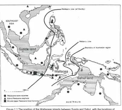
1.1 The position of the Wallacean islands between Sunda and Sahul, with the 1 locations of Pleistocene lithic assemblages
1.2 The shortest routes across Wallacea during the Pleistocene, according to 2 Birdsell
1.3 Sahul northwestern coast opposite Timor during times of low sea level, 3 reconstructed from present-day sea level topography
1.4 Sea level curve for the last glacial cycle, a reconstructed from dated raised 4 coral terraces at Huon Peninsula
1.5 The main geological formations on Rote traced from Geologic Map of 12 Kupang-Atambua Quadrangles, Timor 1979
1.6 The main geological formation on Sawu Island traced from Geologic Map of 12 Kupang-Atambua Quadrangles, Timor 1979
Chapter II
2.1 The archaeological survey region on Rote, with locations of excavated sites 19 and Buhler's research area
2.2 Shelter Din the Pia Hudale rockshelter complex 20
2.3 The Tonggobatu limestone Massif on Rote Islands 22
2.4. A large block of sandstone with an impression like a human foot and lines of 23 small hollows, Dusun Nggefa, Desa Holoama
2.5 A potter's wheel, paddle and anvil from Dusun Oenitas 23
2.6 A lontar wood mortar and a wooden hammer 23
2.7 Northern West Sawu, with location of Lie Mad ira 26
Chapter Ill
3.1 · Classification of vessel shapes according to Anna shepard
Chapter IV
4.1 Plan of the Pia Hudale rock shelter complex, showing the excavation squares in shelter D
4.2 The Stratigraphy of Pia Hudale
4.3 Shell bead and shell ornaments from Pia Hudale 4.4
4.5
4.6
Shaped Gafrarium shells
Absolute abundance of shell famillies, all squares combines, per spit, Pia Hudale
Relative abundance of shell famillies, all squares combines, per spit, Pia
4.7
4.8
Hudale
Glossed fiakes from Pia Hudale
Retouched pieces, Pia Hudale
ChapterV
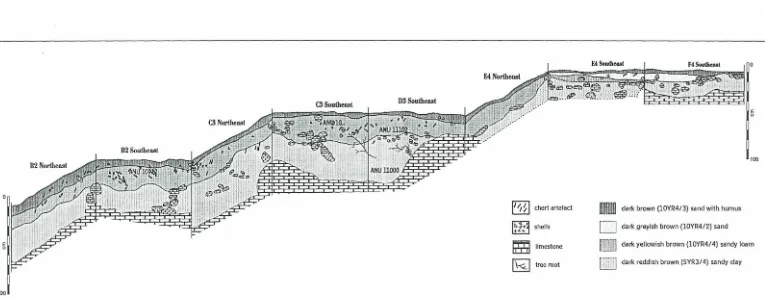
5.1 Plan and section of the T onggobatu rockshelter complex 5.2 Section of trench c 3-d 3 and squars f 3, Lua Mangetek 5.3 Non-Chert fiaked stone artefacts, Lua Mangetek 5.4 Retouched pieces, Lua Mangetek
5.5 Cores from Lua Mangetek
5.6 Flakes with parallel ridges, some with blade proportion, Lua Mangetek 5.7 Cut cones shell, Mangetek
5.8 Absolute abundances (MNI) of shell families in trench C 3D 3 Lua Mangetek 5.9 Relative
5.10 Rim profiles from Lua Mangetek
5.11 Section of trench TP-EX Lua Meko
5.12 Bivalve shell scraper from Lua Meko 5.13 Retouched triodacna shell tool, Lea Meko
5.14 Round shell beads, pointed shell bead, perforated aliva shekk, and shell bead preform
5.15 Absolute abundance of shell famillies, Lua Meko
5.16 Relative abundance of shell famillies, Lua Meko
5.17 Rates of stone artefact discard for Lua Meko
5.18 Gloss-bearing fiakes, Lua Meko 5.19 Reouched pieces, Lua Meko
5.20 Two fiaked artefacts of siliceous sandstone from the base of Lua Meko
5. 21 Split cores from Lua Meko
5.22 Lua Meko cores
Chapter VI
6. 1 Plan and section of Lie Madira, showing the position of test pit
6.2 Section of test pit, Lie Mad ira, Sawu Island
6. 3 Round cut Conus shell, Lie Madira
6.4 Changing rates of shell discard per century in Lie Mad ira
6.5 Absolute abundance of shell famillies, Lie Mad ira
6. 6 Relative abundance of shell famillies, Lie Mad ira
6. 7 Average weight of Trochus shells by spit in the Lie Mad ira
6.8 Rates of stone artefacts discard per 100 years interval, Lie Mad ira 6.9 Retouched pieces, Lie Madira
6. 10 Retouched pieces, Lie Madira
6. 11 Flakes with modification around the platform edge 6. 12 Lie Madira cores
6. 13 Two rim profiles from Lie Madira
Chapter VII
7.1 PCA graph of Lie Madira and modern Mesara samples 7. 2 PCA graph of all the Sawu and Rote samples
7.3 7.4 7.5 7.6
PCA graph of Sawu and East Timor samples
PCA graph of the clay composition of pottery sample from Rote PCA graph of pottery samples from Rote and East Timor PCA graph of pottery samples from East Timor sites
Chapter IX
9. 1 Tanged point and backed blade Uai Bobo 1, East Timor 9.2 Backed blade, Uai Bobo 2, East Timor
126 127 130 131 132 133 135
139 139 140 144 145 152
CHAPTER I
INTRODUCTION
Between the Sunda and Sahul shelves lie the Wallacean islands, never attached to larger
land masses during Pleistocene times. This is the most geologically complex and active
region within Indonesia (Bemmelen 1949; Audley-Charles 1981 ), due to its position at the
meeting point of four geological plates: the Indo-Australian Plate, the Pacific Plate, the
Eurasian Plate and the Philippine Sea Plate.
The Wallacean islands belong to two main groups - the northern consisting of Sulawesi
and Maluku, and the southern consisting of the Nusa Tenggara chain (Figure1.1).
AUSTRALIA
[image:16.596.92.496.336.702.2]These chains of islands must have been used as bridges by early human populations
crossing from Sunda to Sahul, and vice versa, during the time-span of human occupation
of the region. The capacity of humans to cross water gaps in Wallacea during the
Pleistocene is an attractive topic for archaeologists since it implies a presence of sea craft
and allied technology.
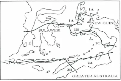
Birdsell (1977) was the first to theorise about the human migration routes followed to cross
the water gaps from Sunda to Sahul. He favoured two possible routes (see Figure1.2),
starting from Sundaland. The first (northern) route crossed from Borneo to Sulawesi and
then to the Sula Islands. From Sula, one route went via Halmahera to the Bird's Head of
western New Guinea, and another went to the southern Moluccan island of Seram, from
where people could cross to New Guinea directly, or travel via Aru to southern New
Guinea. The second, southern, route crossed Lombok Strait from Bali and continued
through the Nusa Tenggara 'stepping stone islands' to Timor, from where one could travel
through small islands to reach the Kai Islands and then the Sahul shelf in southern New
Guinea, or cross the Timor sea southwards to reach Northern Australia.
IA o
[image:17.596.88.494.477.748.2]The question of when humans first crossed from Sunda to Sahul is still a most intriguing issue in archaeology. Based on considerations of distances and island target angles, mediated by other factors such as intervisibility, patterns of winds and currents and island sizes, Irwin (1991) claimed that some of the routes hypothesised by Birdsell (1977) were more likely to be chosen than others. He argued that the northern route was more likely than the southern. His argument was based on intervisibility between the islands, and this vanishes at the end of the southern route, especially between Timor and Northern Australia. This argument is actually challenged by the fact that there are many small island groups off northern Australia that emerged when the sea level decreased. During the Last Glacial Maximum and as far as back 60,000 years ago, there would have been more than 60 small emergent islands to the south of Timor, mostly flat continental shelf islands stretching along the edge of the Sahul shelf for 750 km (see figure 1.3) (Mulvaney & Kamminga 1999: 11 0).
..
~.... :.o = ~· ..
~-· .··
.,-Q
4. -.. •
.
100km 100miles
AUSTRALIA
[image:18.601.125.461.407.731.2]These islands could have been used as stepping stones to reach northwest Australia. As
targets, they would have been easier to reach than single small isolated islands, especially
when navigation was still simple (see Keegan and Diamond 1987 on the 'configurational
effect').
Bellwood (1993) is in agreement with Butlin (1989) in arguing that the route via Nusa
Tenggara was very attractive, since the main obstacle people had to face was crossing
Lombok Strait. Once they succeeded in crossing this, prehistoric seafarers could perhaps
have walked to Alar during periods of glacial low sea level.
One topic focused upon in the many writings about this issue is that of the magnitude and
chronology of sea level change during the Pleistocene and Holocene. There is often an
assumption that the first migration across the sea was likely to have occurred when the
water gaps were at a minimum, in periods of low sea level. But Chappell (1991) believes
that the absolute widths of the water gaps might not have been the main factor in
encouraging or discouraging migration during the Pleistocene.
Based on his research on the Huon Peninsula of New Guinea, John Chappell has
produced a sea level curve covering the last glacial cycle. From this curve it can be seen
that, at about 120,000 years ago, the sea level was higher than it is now, then it gradually
fell to reach its lowest level at about 20,000 years ago, during the Last Glacial Maximum
(figure 1. 4).
thousands of years before present
140 100 80 60 40 0
sea level 0 i----'..,-;~,.---'---"'----'----'---'----''---'---'---'---L----'--120 20
.Du-·50
·100
m
But archaeology shows clearly that humans had reached Sahullong before 18,000 years ago. Accepted dates for the oldest humans in Sahul are now at least 42,000 to 48,000 years ago (Gillespie 2002). During this period the sea level was 50 m below the present so the water gaps between islands were wider than during the Last Glacial Maximum, when the sea level was 120 m below the present. This indicates that Chappell's arguments can be accepted, although humans would still presumably have chosen the easiest available routes.
1. Issues highlighted by archaeological studies in Nusa Tenggara
The question of when the first human settlers arrived in the Wallacean islands, especially Nusa Tenggara, is still a very central one. In 1970, stone tools claimed to be in association with Stegodon bones were reported from central Flores by Maringer and Verhoeven. The stone artefacts consisted of pebble tools, retouched flakes and one small bifacial axe (Bellwood 1997:67, Maringer and Verhoeven 1970). Then, in 1991-1992, an Indonesian-Dutch expedition reexamined the sites visited by Maringer and Verhoeven and excavated more stone tools from a location near Mata Menge (Bergh et at. 1996; Bellwood 1997). Together with the Stegodon bones, some tools of chert and basalt were also found, and claimed to be human-made. At Tangi Tala, a village near the first findings by Verhoeven and Maringer, an older deposit yielded bones of a pygmy Stegodon, a large tortoise and Komodo dragon (Varanus komodoensis), but without stone tools or other indications of a .
human presence. If the palaeomagnetic dating is to be believed, the evidence from Mata Menge would indicate that hominids arrived in Flores 750,000 years ago (Bergh et at. 1996).
also dates this assemblage to about 800,000 years ago, suggesting that Homo erectus
arrived in Nusa Tenggara during the Middle Pleistocene.
Archaeological research in the cave of Liang Bua (Flores) in 2001-2002 by Marwood and
his team is claimed to have strengthened this hypothesis. Excavations that reached 8.5 m
in depth have yielded signs of replacement of early hominid populations by modern
humans (Michael Marwood 2002, lecture given at Gadjah Mada University), although full
details of this research are not yet available.
While the evidence that Homo erectus reached Nusa Tenggara seems to be getting
stronger, the evidence from other regions of eastern Indonesia does not yet extend earlier
than the Upper Pleistocene and the presence of humans of anatomically modern
morphology. At Leang Burung in South Sulawesi, humans had arrived by 31,000 BP
(Glover 1981 ). Based on the results of recent excavations, the arrival of humans occurred
at least 27,000 years ago on Aru island (O'Connor & Veth 2000), and c.35,000 years ago
in Lene Hara in Timor Leste (O'Connor 2002). Marwood and Soejono are currently waiting
for luminescence dates for the first arrival of Homo sapiens in Liang Bua, but Marwood
(pers. comm) anticipates a date of 50,000 BP or earlier. If this estimate can be confirmed,
suggesting an arrival of modern humans at about 50,000 years ago (as in Australia), then
the arrival of Homo sapiens in Nusa Tenggara occurred probably earlier than in the
northern Wallacean islands (e.g. 32,000 BP in Golo Cave on Gebe: Bellwood eta/. 1998).
The colonisation by modern humans of Nusa Tenggara, especially Rote and Sawu, and
their cultural characteristics are the central topics of discussion in this thesis.
Besides interest in the Pleistocene period, recent studies focused on Holocene
archaeology in Nusa Tenggara include a study of pottery technology and function in
several Flores sites (Sumijati 1994); several studies of megalithic structures; changing
economic patterns in some sites in East Timor (Glover 1972); and the economic record in
Oelnaik Cave, Camplong, in West Timor (Nies Anggraeni 1989).
In addition, earlier archaeological research was carried out in the Wallacean islands by
Heekeren in 1952 (Heekeren 1972). Verhoeven did many excavations in caves and rockshelters on Flores, especially in the cave of Liang Toge, from where the mammalian findings were analysed by Hooijer (1957; 1967; Heekeren 1972) and the human bones and crania by Jacob (1967). Verhoeven excavated in Liang Momer in western Flores; in Liang Panas at Longgo Dalang, Manggarai; in Gua Ala south of Liang Momer; at Aimere open site; and in the caves of Liang Baja, Liang Boto, Liang Bua and Liang Rundung. Van Heekeren also undertook some excavations in Liang Rundung. Important finds from this site include a lozenge-shaped pendant of pearl shell and another accessory made of shell in the shape of a fish (Heekeren 1972:146).
If we look back at the progress of archaeological research in Nusa Tenggara, it can be seen that it has been centered mainly on Flores and Timor. This means that the spread of cultural traits along the whole Nusa Tenggara chain during the Holocene period is not fully understood. Take, for example, the puzzle about the spread of microlithic technology during the mid Holocene. Microlithic backed blade industries are absent in the East Timor sites according to Glover (1972). Small stone tools occur in several caves excavated by Buhler in West Timor (Niki-Niki Cave in the neighbourhood of So'e, and also the excavation by him at Baguia, East Timor), but they are not backed blade microliths. Verhoeven discovered microlithic industries at some of his excavated sites in Flores but the illustration in his report shows that these are not backed blades (Meringer &
Verhoeven 1970).
However, industries of this type occur in several sites in South Sulawesi e.g. at Ulu Leang and Leang Burung (Glover and Presland 1985). Whether such technologies are really absent in Nusa Tenggara currently remains unknown owing to the many gaps in exploration.
Some basal layers of the sites excavated by Buhler on Rote (Sarasin 1936), and many of the basal layers of the Flores sites excavated by Verhoeven, might be of Late Pleistocene date, but no dating is available at the time of thesis preparation from any of these sites except for the upper layer of Liang Toge, from which bone taken from a female skeleton has been dated to 3550 ± 525 BP (Heekeren 1972:141; Jacob 1967).
Another uncertainty in relation to the spread of cultural traits through Nusa Tennggara revolves around the occurrence of tanged stone tools, which are especially characteristic of the Niki-niki cave assemblage in West Timor (Verhoeven 1959) and Uai Bobo 1 in East Timor (Glover 1986). But neither of these forms have been reported from other sites on Timor and Rote (Sarasin 1936; Almeida & Zybzweski 1967; Glover 1986; O'Connor et at. 2002). The distributions of these two types of technology will need to be reexamined as new sites are found.
So far, most previous reports of stone artefacts from Nusa Tenggara have only presented very general descriptions of selected stone types, with little metrical analysis or technological information. However, metrical analysis has been carried out for the East Timor cave sites excavated by Glover (1972, 1986). Behavioural aspects of stone technology and the relationships between technologies, subsistence and mobility patterns, and environmental variables, as for instance carried out recently for backed artifacts in Australia by Hiscock (2002), have never been discussed before for Nusa Tenggara.
Considering all the problems that still exist for archaeology in Nusa Tenggara, the crucial requirement at present is to conduct more research on those islands which remain unknown archaeologically, in order to increase the database of cultural assemblages. With this in mind, I decided to undertake archaeological research on Sawu and Rote Islands, particularly in rock shelter and cave sites. The geographic positions of Sawu and Rote in Nusa Tenggara, close to Northern Australia, cause these islands to form an interesting archaeological research focus.
The study involved both survey and excavation of a number of contexts dating from the Late Pleistocene and early to middle Holocene periods. Particular attention is paid to the relationships between various technological variables and intensities of occupation, as reflected in the rates of stone artefact discard and shell food remains, frequencies of retouched tools and other utilised stone artefacts. Another aim was to investigate the spread of several technological items in Nusa Tenggara, such as the tanged points found in some Timor sites, and traditions of making and using pottery. The dates for the introduction of animal species not native to Nusa Tenggara are also considered. In particular, important questions concern the role played by Nusa Tenggara in the spread of Neolithic, presumably ancestral Austronesian cultures, within the past 4000 years or so.
2. The geblogical and environmental backgrounds
All the outer arc islands are part of the outer Banda arc. From west to east, they are
Raijua, Sawu, Rote, Semau, Kambing, Timor, Kisar, Leti, Moa Laker, Sermata, Luang,
and Babar. The basal structure of most of these outer Banda arc Islands is derived from
the Australian continental margin (Audley Charles 1993; Burrett et at. 1991; Monk 1997),
and all have complex sequences of sedimentary and metamorphic rocks. Massive fringing
reef limestone is frequently uplifted many hundred of metres, especially along coastlines.
These two components, the complex basement rock (including schists) and the limestone,
occur in varying proportions on different islands.
2.1 Geology of Rote and Sawu
The main geological formations on Rote and Sawu, in order of age, are presented in
· figures 1. 5 and 1. 6 ( Geological Map of the Kupang-Atambua Quadrangles, Timor,
published by the Geological Research and Development Center 1979):
1. The Bisane Formation (Pb) dates from the Permian and occurs in the interior of
Sawu. It comprises shale, siltstone, sandstone and slate.
2. The Aitutu Formation (Tra) is the oldest formation on Rote, dating to the Permian
and Triassic. It lies to the north of the excavated sites on Rote. It consists of
siltstone, marl and limestone. Quartz sandstone, micaceous sandstone, chert and
crystalline limestone layers are intercalated.
3. The Ofu Formation (Tko ), of Cretaceous-Eocene date is located in southern Sawu
and does not occur on Rote. The formation consists of deep sea sediments- pink
to reddish brown calcilutite, marl and shale, with intercalations of yellowish
radiolarian chert in the lower part. The chert colours are red, brown, orange and
greenish yellow.
4. The Bobonaro Complex (Tb), of Eocene-Pliocene date, is located mostly in the
interiors of Rote and Sawu. Lithologically, this formation consist of two principal
sandstone from the Bisane formation, or limestone, chert and ultrabasic rock from
the Noele and Ofu Formations.
5. The Noele Formation (Qtn), of Pliocene-Pleistocene age, is spread patchily
around the southern coast and some northeastern parts of Rote. On Sawu, this
formation exists in the east. It is characterised by sandy marl interbedded with
sandstone, conglomerate, and a few dacitic tuff layers.
6. Coralline limestone (QI). This is a Pleistocene formation that surrounds Rote and
Sawu, with some interior patches. It commonly consists of white to yellowish,
sometimes reddish, coral limestone and marly limestone. In East Timor this
formation is called Baucau limestone.
7. Holocene alluvial sediments (Qa) in stream valleys and coastal plains,
10°45' s
0 . 5km .
Figure 1.5. The main geological formations on Roti Island.
Traced from Geologic Map of The Kupang-Atambua Quadrangles, Timor 1979
""'
10'11f1
GEOLOGIC MAP OF THE SEWU ISLAND, NUSA TENGGARA TIMUR
0 10 Kilometers
121"•5'
N
W*E
sFigure 1.6. The main geological formations on Sawu Island.
Traced from Geologic Map of The Kupang-Atambua Quadrangles, Timor 1979 (Agus Tri H.)
[image:27.846.46.386.56.496.2] [image:27.846.394.768.119.408.2]2.2 The contemporary vegetation and faunas of Nusa Tenggara
Rote and Sawu islands are located in eastern Nusa Tenggara (Nusa Tenggara Timur), the
driest area in the Indonesian archipelago. Climatic factors mean that rainforest only occurs
on higher ground on Flores and Timor (Monk et al1997: 187, 234). On Rote, the interior
has patches of moist decidous forest, but the coastline has mainly dry deciduous forest.
All of Sawu has only dry deciduous forest, and a small area on the northern west coast is
covered by thorn forest. The coastal regions of Timor have combinations of dry and moist
deciduous forest, sometimes with thorn forest, whereas the interior has patchy evergreen
rainforest. Sumba and Flores have evergreen forests mainly on their western ends.
Tamarind savanna also occurs throughout eastern Nusa Tenggara. In Central Flores,
eastward to Wetar Island, Eucalyptus alba savanna is dominant. West Nusa Tenggara
has large savanna areas with Albizia chinensis, and Melaleuca cajuputi occurs frequently
in Central Flores. Casuarina junghuhniana savanna is characteristic also of Sumba and
Timor (Monk et al 1997: 195-202). Today, palm savanna is the dominant type of open
country vegetation found on Komodo, Rote and Sawu, and on Timor, especially on the
drier parts of many flat flood plains. Whitmore (1989), as cited by Monk, suggest that the
present savannas and grasslands of eastern Nusa Tenggara are derived from former
monsoon forest, as a result of burning (Monk eta/. 1997:287, 297).
Recently introduced animals in Nusa Tenggara include the Malay civet (Viverra
tangalunga), a squirrel (Cal/osciurus notatus), murid rodents, deer, felids and pangolin.
The present day native vertebrate fauna of Rote Island is relatively impoverished
(Kitchener & Maryanto 1995; Kitchener & Suyanto 1996) and consists mainly of rodents,
bats and reptiles. The total number of bird species on Rote is 119, compared with 230
species on Timor (Johnstone & Jepon (1997; Johnstone & Darrel 1997). Many of these
2.3 The Regional Palaeoenvironment during the Pleistocene and Holocene
The general trend of climate change from the Late Pleistocene into the Holocene in Nusa
Tenggara can be inferred from records taken from Timor Island (Timor Trench core: Kaars
1990) and from the Lombok Ridge core (Kaars 1990; Wang et a/. 1999). The data from
these marine cores can be interpreted largely as a reflection of the vegetation histories,
and associated changes change of climate, in northwestern Australia and Nusa Tenggara.
During the last glacial period, there was a combination of drier and cooler climates in the
region, as indicated by extremely low values for mangrove pollen. The pollen record from
the Timor Trench indicates that grassland vegetation advanced from 38,000 to 12,000
B.P., and coastal tropical lowland forest and eucalyptus woodlands contracted. The
greatest expansion of grassland took place between 19,000 and 17,000 B.P., when sea
level was at its lowest. After 19,000 B.P., sea level rose again (Kaars 1990), eventually
reaching its modern level during the mid Holocene.
During warmer interglacial periods, including the Holocene, as inferred from the Lombok
Ridge and Timor Trench cores, higher pollen values occurred for lowland rainforest taxa,
pteridophytes and mangroves (Wang eta/. 1999). At these times, sea levels flooded the
continental shelves, resulting in the coastal spread of mangroves to peak values.
Kershaw (1995) notes that the Pleistocene-Holocene transition incorporated some of the
most dramatic environmental changes in global history. The whole transition spanned
about 11,000 radiocarbon years, from c. 17,000 to 6000 bp, based on pollen records
studied from Irian Jaya, Papua New Guinea and southern Australia. Kershaw recognises
three major phases in the transition from Pleistocene to Holocene as a whole: phase 1
being the late glacial; phase 2 the Pleistocene-Holocene boundary; and phase 3 the early
to middle Holocene.
Although conditions were generally dry during phase 1, the timing of the period of greatest
Lake Carpentaria, Lynch's Crater, and Papua New Guinea. Van Campo (1982 :56) has argued that the northeast monsoon was strengthened during the last glacial maximum.
The Pleistocene-Holocene boundary (phase 2) witnessed very rapid climatic change, and
conditions became more humid and warm. The early to middle Holocene (phase 3)
witnessed the later part of the marine transgression, and Kershaw (1995) states that this
was the period of highest temperature in New Guinea, although there was some spatial
variation.
Based on data from Tioman Island in the South China Sea, Tjia (1983) suggested that
phase 3 sea level increased to 4 m above the present level at 6800 uncal. bp, fell
temporarily at 5000 bp, then rose again to 3.5 m above present level at 4000 bp. After this it fell to +1 m at c 3700 bp, rose to +2.5 m at 3000 bp, and then declined steadily until the early years AD. The southwest monsoon was more intense before 9000 bp and rainfall
was higher than at present, but the climate was getting warmer from 8000-7000 bp so
evaporation would have increased. By 4000 bp, rainfall was becoming increasingly
seasonal in annual distribution.
2.4 Pleistocene to Holocene Faunas in Nusa Tenggara
Based on data from Flores and Timor, it is known that large mammals lived in Nusa Tenggara during the Plio-Pleistocene, such as the pygmy Stegodon sampoensis
timorensis. There was also a giant land tortoise, Geoche/one atlas. Hooijer (1967) also
identified an unidentified murid in association with Stegodon on Flores. The stegodonts had disappeared by the early Holocene, to be replaced on both Flores and Timor by a
Holocene fauna dominated by murids, bats and reptiles. The living representatives of these murids in Nusa Tenggara include the Flores giant rats Papagomys armandvel/ei,
Par, :Jgomys verhoeveni and Spelaeomys florensis. During the Holocene, another distinct
Monk et at. (1997) argue that the major factors that have affected vegetation and faunal
communities in the recent past have been sea-level changes, human migrations, and
agriculture. The Austronesian and Papuan language expansions brought new animals to
this area. From the East Timor data, Glover (1986) notes that macaque monkeys (Macaca
fascicularis), rusa deer ( Cervus timorensis), and the palm civet (Paradoxurus
hermaproditus) all came from the west, whereas the cuscus Phalanger orienta/is was
brought from the east to as far west as Timor.
3. Past archaeological research on Rote and Sawu Islands
Previous archaeological research on these two islands has been very minimal. What we
knew about the archaeology of Rote prior to my research was derived from Buhler's
excavations in 1933, as reported by Sarasin in 1936 (Sarasin 1936). Buhler carried out
some excavations in Dengka Princedom (West Rote), to the northwest of the lakes of
Danau Anak and Danau Toea near the hamlet of Genoeng. He discovered some rock
shelters about 20 minutes from Danau Anak and excavated in two of them. In shelter A,
he found fragments of modern pottery, animal bones and shells in the top layer. From 20
em down to about 1 metre below the surface, "flint" artefacts appeared. The excavation
was stopped after reaching 140 em as the finds became scanty. In another shelter (shelter
B), excavation produced no results.
The report on the Rote research is very brief and further interpretation is difficult. It is not
clear from the report on shelter A what kind of flint artefacts were found, or whether those
from the upper level were similar to those from further down. Artefact densities are not
mentioned either. Buhler also did some excavations in Lua Meol, west of Danau Anak,
where he visited four caves. In one only did he find archaeological remains, in a shelter
open to the south with two niches measuring 3m and 4 m in depth, with maximum heights
of 8 metres. He ·excavated in the two niches, and found in the top layer flint artefacts,
potsherds and many marine shells, with a small pierced disc of pearl shell. Looking at the
illustration, this small pierced disc is very similar to some found in East Timor sites (Glover
In 1986, several archaeological sites on Rote, including the Pia Hudale rock shelter
complex in Desa Mokdale and the Tonggobatu rock shelter complex in Desa Tuanatuk,
were visited by a team from the Indonesian Archaeological Research Centre in Jakarta
(Bintarti et a/. 1986). The locations of the sites were recorded, but excavation was not
undertaken. These two sites are discussed later in this thesis. Some surface Palaeolithic
artefacts have also been claimed from Rote Island (Soejono 1987).
Lie Madira on Sawu was first surveyed by the Indonesian Archaeological Research Centre
(Pusat Penelitian Arkeologi Nasional) in 1980 (Aziz 1980), and some stone artefacts
collected there are held in the Centre in Jakarta. Except for this single visit, no
archaeological research was carried out on Sawu prior to my research.
4. Research questions
Specific questions that will be approached in this thesis are:
1. What are the basic cultural features found in the Rote and Sawu rock shelter
sites? Were there any major cultural changes through time?
2. Were there different intensities of site use during different periods of occupancy?
3. Were there any regional differences in cultural characteristics?
To answer these questions I will be examining the development of stone artefact
manufacture, including the choice and use of raw materials, in each site excavated. I will
also examine whether there were differing intensities of tool use during different periods of
occupancy. The changes through time in quantities and varieties of shell species and their
habitats are also investigated.
The results obtained from the sites on Rote and S~wu are compared with the
archaeological records from several sites in East Timor, an area with quite detailed
archaeological records that are easy to access. General comparisons with other sites in
the lndo-Malaysian archipelago, in order to obtain broader perspectives, especially on
modern human colonisation during the Late Pleistocene and the later Austronesian
CHAPTER II
ROTE AND SAWU SURVEY
1. Survey strategy
The main survey strategy was to locate as many rock shelters and caves as possible on
Rote and Sawu and to determine if they were occupied during prehistoric periods. Then,
sites found were judged in terms of their potential for excavation. Priorities were allocated
in terms of abundance and variety of surface finds, and also the possibility of deep
deposits.
The survey was carried out based on the geological map sheet Kupang-Atambua
(Geological Research and Development Center 1979). This map illustrates the geology of
West Timor, Rote, Sawu and other small islands in the vicinity. Areas with limestone
formations in which rock shelters and caves can be commonly formed were identified for
survey. These data were then combined with information from inhabitants living in nearby
villages, and with data contained in local Departemen Pendidikan dan Kebudayaan
(Education and Culture) archives, before the first field visit was undertaken.
On Rote, limestone formations occur almost everywhere except in some interior regions.
Most survey was carried out in these limestone areas, including the inland Kecamatan
Lobalain (Central Rote). However, survey was not carried out around Danau Tua and
Danau Anak in the vicinity of Dengka in the interior part of Rote, where Buhler did his
excavations (see figure 2.1 ).
On Sawu Island, raised coral reef limestone occurs around the coast of much of the
island. Owing to time constraints, survey was only carried out along the northern and
umba
Sawu Rote
0
w
0 5km
[image:34.604.55.494.94.694.2]---• Site 1 (Tonggobatu Complex) Site 2 (Pia Hudale Complex) Buhler's research area
Figure 2.1 The archaeological survey region on Rote,
1.1 Survey on Rote Island
Lobalain District
Lobalain District is situated in the middle of Rote. Near one of its villages, Desa Mokdale,
there is a long raised coral reef complex with several rock shelters and a cave. People in
the village call this complex Pia Hudale (see figures 2.2). It is situated 90 metres above
sea level and lies about 3 km from the northern coastline. The site is ideal for habitation,
being close to a permanent stream that provides fresh water through the dry season and
[image:35.603.177.438.336.712.2]that today flows north to the coastal village of Namodale.
At present, this long raised coral reef complex is separated into two parts by a road that
goes to the airport. On the west side of the road there are some shelters, and at the end
of the west cliff line is a large cave with a water source in the middle of its
always-inundated floor. All the rock shelters have dry floors and two stay dry during heavy rain.
The east side of the complex has no shelters.
On the floor of most shelters of this complex, marine shells and stone flakes were found
during survey, but the densest evidence for human activity was found in shelter 0, the
largest shelter in the complex, that faces northwest. An abundance of cultural remains
consisting of flakes, cores, shells and several potsherds were spread on its surface.
According to a local inhabitant, Pia Hudale was used for hiding during the Second World
War, so human trampling certainly took place in the recent past. Besides, old people used
to collect chert scattered on the shelter surface to use as strike-a-lights to make fire. This
means that some chert flakes and cores, especially those of larger size, will have been
removed from the site.
Limestone roof fall is plentifully spread on the shelter surface, especially at the rear. The
present shelter floor and its surrounds are flat. Small shrubs, coconut trees, lontar palms,
Celtis and Agathis alba grow in front of the shelter, while above its roof the roots of Ficus
sp dangle down along the drip line and through fissures.
In Dusun Oemau Laen, in Desa Tuanatuk, another complex of raised coral reef with
several shelters was found. Local people call this rock shelter complex Tonggobatu. It lies
about 4 km from the northern coast of Rote (figure 2.3). Unlike the shelters in Pia Hudale
that lie below the general level of the surrounding terrain, those in Tonggobatu are
situated on a hill.
Tonggobatu has several rock shelters that face northwest, and several smaller ones on
the opposite side of the hill. Only in those (a total of five) that face northwest were
abundant stone flakes and shells found on the surface. The densest surface scatters were
found in two shelters called Lua Manggetek (MGT C) and Lua Meko (MGT B) .. Lua
Lua Meko is not very large, and only stone flakes and no sherds were scattered on its
surface. Here, it was predicted that a deep deposit would survive in the area close to the
inside wall of MGT B, where preservation is good and the chance of soil sliding outside the
shelter only very small.
The present environment of the Tonggobatu shelters is very dry, with external vegetation
consisting of Agathis alba, Ficus sp, grass, and kapok trees. However, in front of the raised
coral reef complex there is a small seasonal stream that only carries water during the
rainy season.
Tonggobatu also has some east-facing shelters but these are very damp within and some
are partly filled with massive blocks of roof fall. Except for a few sherds, no artefacts were
found on the surfaces of these sites. The eastern side also has one deep vertical cave
which is not suitable for human occupation.
In Dusun Nggefa, in Desa Holoama, there is another raised coral reef complex, with three
big shelters facing northwest about 4 km from the northern coastline. The surrounding area
is a flat lowland where shrub vegetation grows, dominated by Agathis alba. This group of
shelters was most likely used for habitation, although no surface artefacts were found
when the survey was carried out and the deposits looked thin. In front of this shelter complex there is a large block of sandstone with an impression that looks like a human
foot (figure 2.4) and rows of small hollows. In Maluku Utara, similar features are still used
by local people to crush canarium nuts.
Western Rote District
Several raised coral reef complexes with very small shelters were also found in Western
Rote District. In the Boa Peninsula and Oe Seli, in the southern coastal area, there are
several raised coral reef complexes. However, most of the shelters are very close to sea
level and waves can sometimes enter. Some other rock shelters were situated in the
mangrove area, difficult of access. No artefacts were found around any of these. However,
some sherds were found on the surfaces of several small rock shelters in the northern
coastal area, west of Baa, but no stone artefacts were found in these shelters. Many are
wet inside during the rainy season.
The pottery-making village in Dusun Oenitas, Oenale
Dusun Oenitas is located about 20 km southwest of Baa (see figure 2. 1 for location).
Almost every household here produces pottery, not only for their own needs but also as a
commodity for sale across Rote Island. In 1997, there were 15 households in Dusun
Oenitas still actively making pottery for sale. The pottery was sold from door to door or sold
in the central market in Baa. Several people were seen carrying pottery along the road
from Dusun Oenitas to Baa when the survey was carried out.
In Dusun Oenitas, pottery is made by a combination of the slow wheel and paddle and
anvil methods. The paddle is made of /ontar wood and the anvil is a lontar seed (figure
2.5). Before forming begins, dried local clay is crushed in a /ontar wood mortar (figure 2.6),
then mixed and kneaded with sieved beach sand. The pottery is fired in the open.
Figure 2.5 A potter's wheel, paddle and anvil from Dusun Oenitas (photo by Yogi Piskonata).
Figure 2.6 A lontarwood mortar and a wooden hammer for crushing dried clay
Present day pottery production consists of only plain cooking pots without red slip. There
are several sizes. Local people use the large- and medium-sized cooking pots for cooking
lontar juice to produce brown sugar. Small pots are used for cooking herbal remedies.
Differences in surface treatment between present-day Oenitas pottery and archaeological
sherds can be clearly seen. For purposes of comparison, we bought several pots from
different potters and collected samples of the local clay and sand used in manufacture.
1.2 Sawu Island
An archaeological survey were carried out in West Sawu District (figure 2.7). On the way
from Seba (the Sawu capital) to Mesara village on the western peninsula there are
outcrops of raised coral, but none are high enough to fonn rock shelters. On the northern
side of western Sawu, in Desa Raedewa, there is a long raised coral reef complex called
Lie Da, containing at least three big shelters with abundant scatters of cultural remains.
The biggest shelter had been exploited for bat dung fertilizer in the past. This practice
stopped in 1940s, according to interviewed old people. When the survey was carried out,
there were three fertilizer mining pits up to 1 m deep, indicating heavy disturbance. The
cave deposits were originally more than 1 metre deep. Many stone artefacts from these
pits were scattered on the surface, but no pottery was found.
The site with most potential for excavation is the cave of Lie Madira in Desa Daieko. Lie
Madira is situated 264 m inland from Roa Lie beach on the northern coast of Sawu, a
popular beach for collecting crabs and shells and evaporating sea water for salt. The area
around the cave supports coastal vegetation such as lontar and coconut palms, Pandanus
sp. and shrubs.
Lie Madira has two entrances. One leads into a narrow and long cave used for habitation.
The other leads into another deep and long cave which goes down for about 20 m to a
source of fresh water used by the Desa Daieko villagers. A cement staircase has been
built down to this water source. In the other cave, used for habitation, many stone flakes
Figure 2.7 Northern West Sawu, with the location of Lie Madira. (drawn by Agus Tri Hascaryo)
LIE MADIRA AND MESARA
0 -·- 1 km
\1\
Contour lines ~ River'
...,·"·,
VIllage Road ~ Country Road'
~.VIllage border
.. .
s
Cavers:::::s:J Research area
...
PoUery making villageDrown by AQus Trl H., 2003
N
Some stone flakes were also found outside the cave. No artefacts were found in the inner
water-filled part of the cave.
The present maximum height of the roof of Lie Madira in the habitation area is 3 m. The
length of the cave is 15.50 m from the mouth to the back, and the maximum width is 4.5
m. The present cave mouth is 3 m wide and 1.25 m high. The front has no rock fall, but
the inner area is piled with limestone rubble. The cave inside is very dark and sun cannot
reach very far in. However, the cave is dry enough for habitation.
Another cave visited was Ratu Monepidu, in the southern coastal area (not shown in
figure 2.7). A few land snails were found inside this cave but no stone artefacts. In the
middle of the cave there are two very large piles of roof fall that make it very difficult to
examine the entire surface of the cave and to conduct any excavation. NGl river exists near
this site, but people make gardens around it, suggesting that it could have been used for
habitation in the past.
The modern tradition of pottery making on Sawu
Data on locally-made Sawu pottery can be obtained from the central market in Seba.
Based on interviews with local people and traders in Seba, I discovered that all the pottery
that is sold in the market is brought from Mesara, a small dusun on the northwest side of
Sawu Island. People also said that Mesara is the only pottery making village in Sawu, and
provides all the pottery needs for the island. The potters' male family members often sell
the pottery in the central market in Seba, rather than selling it door to door. People also
travel to Mesara to buy pottery directly from the local potters.
All pots sold in the market are plain, non-red-slipped cooking pots. Interviews with local
people who often visit Mesara informed me that open air firing processes are used, but 1
could not gain other useful details from the interviews because people could only give very
general statements. However, from the physical appearance of the pottery sold in the
market, it can be inferred that the formation processes are similar to those used in Dusun
CHAPTER Ill
EXCAVATION AND LABORATORY METHODS
This chapter describes all the excavation and recording procedures and techniques of
analysis and laboratory methodology applied to investigate the problems identified in
chapter I.
1. Excavation and recording procedures
Generally; in large rock shelters, a grid of one metre squares was laid out first, and then
individual squares were chosen for excavation. Squares were chosen for excavation within
the grids based on consideration of the possibility of finding deep deposits, lack of
disturbance, and as little root penetration as possible. For small rock shelters and caves,
the locations for test pits were chosen individually.
During excavation, the depths of all spits and major finds were measured below a datum
point established at the ground level of the first square to be excavated. Before scraping
the first spit, artefacts, bones and other archaeological remains found on the surface were
collected, after their locations were recorded. Excavation was carried out by 5 em spits.
Because of the dryne·ss of the sediments, all excavated soil was dry sieved through first a
4 mm sieve and then a 0.5 mm sieve, the latter to catch very small remains such as fish
and small animal bones, and glass and shell beads.
In the field, all archaeological finds were classified into stone artefacts, sherds, bones,
shells, and ornaments, all kept separately for each spit. Bones were then separated in the
laboratory into human and animal bones. Sediment samples were collected from each
layer from the excavation sections after excavation was completed, starting from the
bottom of each profile in order to ensure no mixing as a result of particles falling from
above.
After the excavation was completed for each square, a section drawing of the visible
Munsell color chart in both moist and dry conditions. A pinch of soil from each layer was
then matched with a standard texture chart. Texture was recorded using the finger rubbing
method following Limbrey (1975). Structures and boundaries between layers were also
recorded as sharp or merging in the field.
2. The identification of transformation processes in caves
Archaeological assemblages uncovered from excavation in caves often do not represent
direct in situ discard by the humans who occupied the sites in prehistoric times. During the
thousands of years between original discard and the time when an archaeologist decides
to survey and excavate, there are several processes that can change the distribution of
data in a cave site, either horizontally or vertically. In relation to the occupation sequence,
identifying any vertical transformation, either natural or cultural, that has taken place in a
site is crucial (Rowlett and Robbins 1982). Due to vertical transformation, items originally
deposited in one level can eventually be placed several layers apa~ vertically. Conversely,
a single deposit can contain the products of many different depositional cycles. It is thus
very important to identify the processes responsible for the formation of each depositional
unit within a site.
To identify the occurrence of transformation processes and disturbance in each site,
several strategies were applied. The topography of the site was considered, layers were
examined for evidence of disturbance, conjoining or refitting analysis of stone artifacts and
potsherds was undertaken, and the degrees of weathering and mineralization of human
bones were identified in the laboratory, together with the total number of individuals
represented by all bone fragments recovered in a site. For the rock shelters considered
here, ploughing activity is clearly not a problem. But animal and human trampling have to
be considered; although likely to have been minimal, an experiment by Schiffer (1987;
Limbrey 1975) shows that large objects tend to move upwards, while small objects tend to
move downwards as a result of trampling.
The effects of trampling depend on several factors, including the quantity of cultural
material on the ground surface, the intensity of the trampling, and the nature of the surface
sediments. Furthermore, the penetrability of a surface sediment is determined to a degree